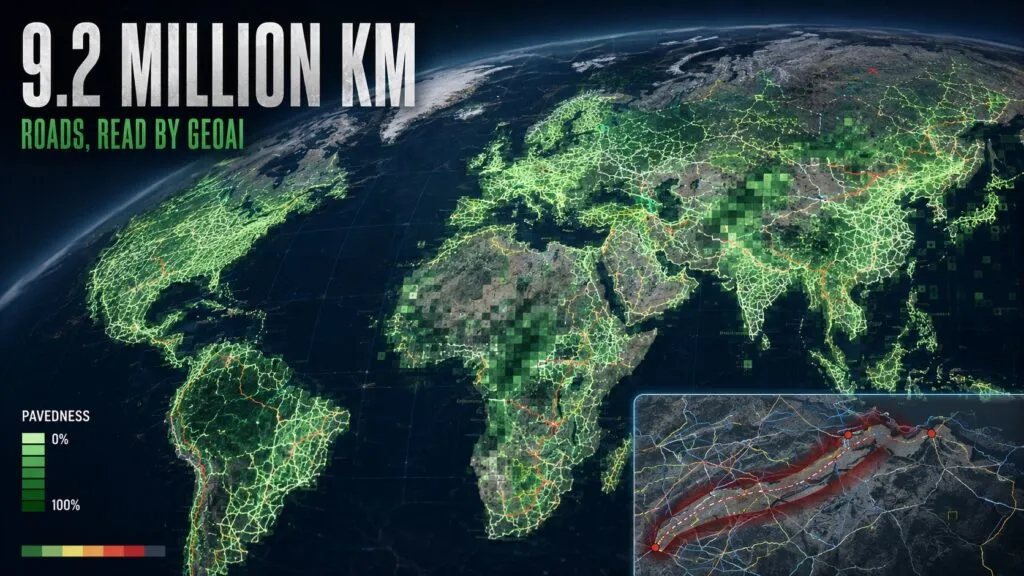

Most global road maps can tell us where a road is. Far fewer can tell us whether it is paved, how wide it is, or whether it might keep a relief convoy moving after a flood.
A new peer-reviewed study in Nature Communications shows how satellite imagery and deep learning can begin to close that gap. Researchers from Heidelberg University and HeiGIT mapped road surface type and estimated width across 9.2 million kilometres of the world’s critical arterial roads.
The result is not simply a more complete road inventory. It is an attempt to turn imagery into infrastructure intelligence.
From road lines to road condition
The team started with OpenStreetMap geometries for motorways, trunk, primary and secondary roads. It then analysed 3 to 4 metre PlanetScope imagery from 2020 and 2024 using a fine-tuned Mask2Former segmentation model.
The resulting dataset covers 95.5% of the selected 9.2 million-kilometre network. Nearly half of those roads previously lacked a surface classification. The researchers also found that OpenStreetMap tags for unpaved roads achieved only 26% average global accuracy in their human-validated comparison, often because attributes had not kept pace with development on the ground.
This is an important distinction. OpenStreetMap remains the indispensable geometry layer, while Earth observation provides a way to update physical attributes at scale. The two are complementary rather than competing systems.
A new layer for infrastructure decisions
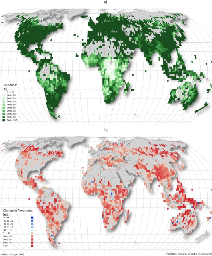
Road surface data revealed a pronounced urban-rural divide. Urban arterial networks were more than 93% paved across all regions, while rural pavedness in Sub-Saharan Africa averaged 61.4%, compared with 97.2% in Europe and Central Asia.
The researchers also found that changes in pavedness between 2020 and 2024 correlated with human development after accounting for each country’s starting point. That does not prove that paving causes development, but it suggests that frequently updated road-condition maps could complement slower official statistics and coarse proxies such as night-time lights.
The most operational part of the work is a Humanitarian Passability Score. By combining estimated width and surface type, the framework distinguishes high-capacity supply corridors from narrow or weather-sensitive chokepoints.
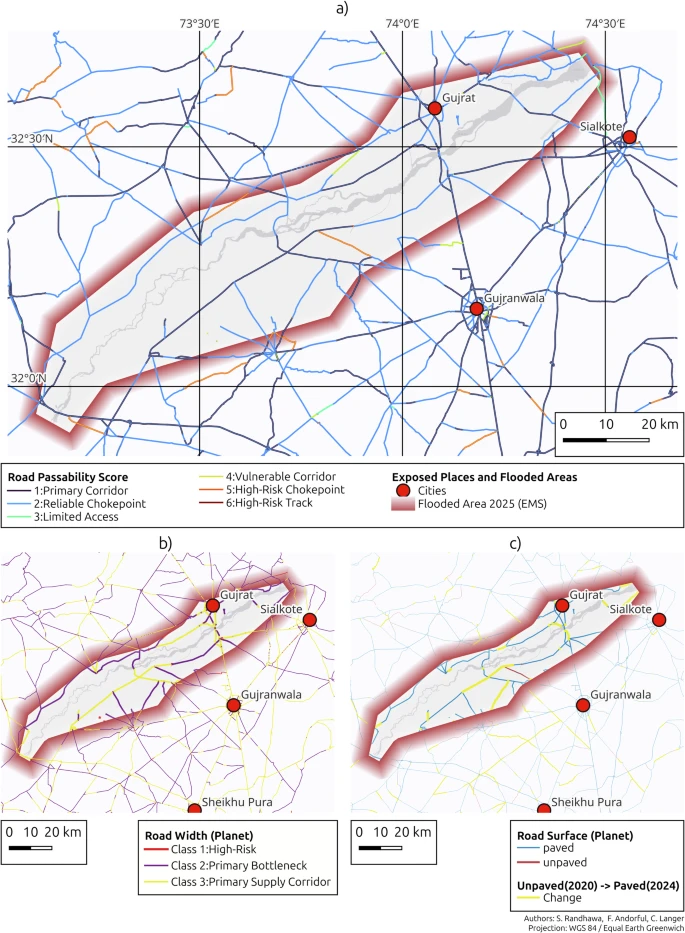
For humanitarian teams, development banks and governments, that is potentially more useful than another global road centreline dataset. It begins to answer whether a mapped route is likely to support the vehicles and loads required during an emergency.
The resolution ceiling still matters
The authors are careful about the limitations. PlanetScope imagery cannot resolve individual lanes, so road width is a first-order estimate. Clouds, shadows, vegetation, moisture and seasonal changes can also create apparent deterioration or improvement where none occurred.
The passability score is not a live declaration that a road is open. It is a structural indicator that would still need recent weather observations, flood data and field verification before operational use.
There is also a licensing distinction. The derived vector dataset is available through the Humanitarian Data Exchange under a non-commercial Creative Commons licence, while the underlying Planet imagery cannot be redistributed.
Still, the strategic direction is clear. GeoAI is moving beyond extracting buildings and road geometry. The next valuable products will describe what infrastructure is made of, how it changes and what it can actually support.



#GeoAI


Next article
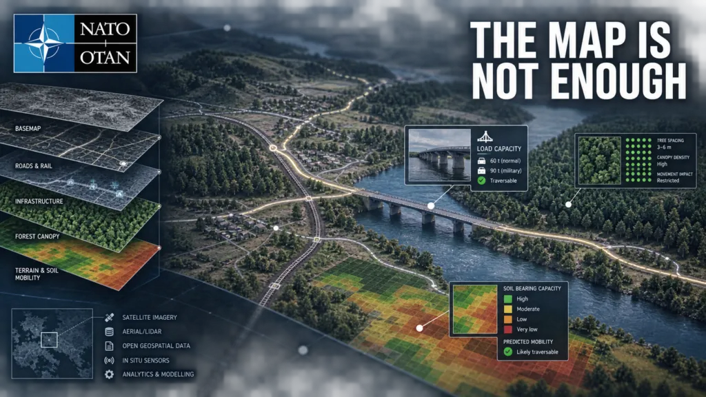
NATO is testing the market for something more demanding than another global map. A new request for information from the NATO Communications and Information Agency, or NCIA, asks industry for wide-area or potentially global geospatial datasets that can support military operations. The requirements reveal what operational geospatial data looks like when a map must inform whether a force can cross a bridge, move through a forest or reroute around damaged infrastructure.
The request, RFI-191786-GEOOPS, is market research rather than a tender or contract award. Responses are due on 22 September 2026, and only companies from NATO member countries may participate. Still, it provides an unusually detailed signal about the Alliance’s future data needs.
From basemaps to operational decisions
NCIA identifies three priority areas: soil, transportation and land cover, particularly forest characteristics.
For soil, NATO is looking for seamless global or wide-area information comparable with 30-metre resolution. The transportation requirement goes much further than ordinary road geometry. It asks about military load classifications, road clearance, surface and subgrade strength, bridge condition, rail loading gauges, staging facilities and connections between road, rail, air and maritime networks.
Forest data is expected to describe not only land-cover classes but physical characteristics such as tree type, stem spacing, trunk diameter, branch height and canopy closure. Those attributes can help assess whether terrain can be crossed or bypassed.
For every proposed dataset, vendors must explain provenance, update cycles, coverage, production time, quality assurance, metadata, attribute schemas and compatibility with NATO’s CoreGIS environment. They must also price two licensing models: use within the NATO enterprise, and broader use by NATO nations and approved non-NATO entities.
That list is strategically important. It shows that the difficult part is not simply acquiring imagery or vector geometry. NATO wants data that is current, attributable, interoperable and legally deployable across a multinational organization.
A two-layer procurement strategy
The RFI sits alongside a separate NCIA procurement for a Global Seamless Vector Basemap Data Package. That planned contract, valued at an estimated €3.5 million, is expected to deliver a foundation compliant with the NATO Geospatial Information Framework, with a solicitation planned for October 2026.
Together, the two initiatives suggest a layered approach. One procurement establishes a common reference map. The other explores operational attributes that can turn that foundation into a decision-support system.
Civilian global datasets only solve part of the problem. Overture Maps provides an open global transportation graph derived mainly from OpenStreetMap and enhanced with TomTom and other sources. ESA WorldCover offers global land-cover mapping at 10 metres. ISRIC’s SoilGrids maps fourteen soil properties worldwide, but at 250-metre resolution.
These resources could contribute to a solution, but none provides the entire package requested by NATO. A road centreline is not the same as a verified route for a particular vehicle. A forest class does not reveal trunk spacing or the clearance beneath branches. A global soil model may be too coarse for local mobility decisions. Commercial vendors may therefore compete not only on coverage, but on their ability to fuse open, national and proprietary sources into a defensible operational product.
The real competition is data governance
Likely suppliers span several parts of the geospatial market: commercial basemap and navigation providers, satellite operators, terrain and land-cover specialists, defence intelligence contractors and companies that curate national data into global products. NCIA does not name bidders, and the RFI does not establish that any particular company can meet the requirement.
The advantage may be less about owning one exclusive dataset and more about maintaining a reliable supply chain. Vendors must show how features were produced, checked and licensed for redistribution across the Alliance.
That challenge becomes sharper during a crisis. Commercial data can be highly current, but licenses designed for one enterprise may not permit rapid sharing with 32 allies or partner organizations. National authoritative data can be more detailed, but schemas, classifications and release rules vary. Open datasets offer scale and transparency, but completeness and update consistency are uneven.
NATO is confronting the same problem that many large geospatial organizations face, only with higher consequences: the map is useful only when users can trust both the feature and the permission to use it.
Part of a wider data transformation
The procurement also aligns with NATO’s Alliance Data Sharing Ecosystem. During Bold Quest 2026, five nations tested exchanging data through the developing platform. NATO says the work exposed barriers involving quality, access and speed.
That context makes the RFI more than a search for another supplier. It is an attempt to define the information layer on which future analytics, logistics planning and AI-supported workflows may depend.
Important questions remain unanswered. NCIA has not disclosed a budget, acquisition timetable or accuracy thresholds for the operational datasets. It is also unclear how frequently critical infrastructure attributes must be refreshed, how disputed observations will be resolved, and how data will be protected in disconnected or contested environments.
But the direction is clear. NATO does not merely want a digital representation of the world. It wants geospatial information that can explain what forces can do in that world, with provenance, licensing and interoperability strong enough for multinational operations.


