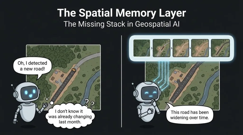
The Spatial Memory Layer: The Missing Stack in Geospatial AI

GeoAI is making progress in extracting information from satellite and aerial imagery. Current models can detect buildings, delineate roads, classify land cover, and map flood extent. Recent Earth observation models also learn from multi-temporal satellite observations, combine radar and optical imagery, and incorporate geographic location context.
However, these advances do not fully address a separate problem: how to maintain persistent, reusable knowledge about the same locations across long time periods. A model may analyse a forest today, analyse it again next week, and still treat the new image mostly as a fresh task. It can detect tree cover again, but it does not always carry forward a structured memory of what changed, what stayed stable, and what was already known about that exact location.
This is the gap. Existing GeoAI models can model temporal observations, but they rarely maintain persistent, structured knowledge about locations that can be updated and reused across long time periods.
SkySense shows how the field is already moving beyond single-image learning by using temporal sequences, optical imagery, SAR, and geo-context. But even this kind of progress points to the next question: how do we turn repeated observations into durable place knowledge?
This article argues that GeoAI needs a spatial memory layer: a missing part of the stack that helps models move from detecting features in images to understanding how places are changing over time.
Humans Don’t See Places That Way
Human geographers do not read landscapes as isolated images. When an analyst looks at a satellite image of a town, they also bring memory, field knowledge, and environmental context.
A widened road is not just a road. It may be part of a new logistics corridor. A shifting riverbank is not just a different water boundary. It may be part of a seasonal monsoon pattern. A brown patch in a forest is not only a land-cover class. It may be an area recovering after a wildfire.
That memory changes the interpretation. It helps separate typical seasonal change from unusual disturbance, and long-term recovery from sudden damage.
Earth observation already depends on this idea. Satellite observations support climate adaptation because they can track geo-hazards, risks, and long-term change across large areas. NASA’s data maturity levels also show why validated Earth observation products matter for climate studies, especially when records expand over time.
The lesson for GeoAI is: places have histories. A model that does not remember those histories is only seeing part of the landscape.
What the Spatial Memory Layer Actually Is
A spatial memory layer is a persistent, geo-referenced knowledge store that maintains historical observations, object states, relationships, and contextual information across time. It allows future GeoAI systems to reason beyond one image inference.
It would store several kinds of information.
- First, it would store historical baselines: what a field, forest, river, or neighbourhood typically looks like across seasons.
- Second, it would track persistent objects: buildings, roads, farms, wetlands, and other features that should not be re-identified from scratch every time.
- Third, it would store event history: when land was cleared, when construction started, when flooding happened, or when vegetation recovered.
- Fourth, it would carry temporal confidence: whether an apparent change is reliable, or whether clouds, haze, shadows, snow, or missing observations may have affected the result.
Geo-referenced memory points toward this kind of layer. It frames memory as one of the primitives needed for GeoAI assistants that can support real GIS work. The limitation is that this is still an agency concept, not yet a complete operational architecture for long-term Earth observation memory.
That is where the idea becomes useful. The memory layer would not replace foundation models. It would give them a place-based record to read from and write to.
What Existing Approaches Solve and What They Don’t
The spatial memory layer should not be presented as if all existing methods ignore time. They do not. The stronger argument is that existing methods solve parts of the problem, but they do not yet provide a unified, persistent memory for places.
Temporal transformers are one example. They can learn short-term or sequence-based patterns from Earth observation data, which makes them useful for crop monitoring, vegetation cycles, weather-sensitive signals, and multi-date classification. But they usually operate inside a bounded training or inference window. They do not automatically maintain a persistent global state for every location.
Retrieval systems solve a different part of the problem. Vector databases can find past observations that look similar to a new image. But similarity is not the same as memory. An embedding can say that two scenes are close in feature space. It does not necessarily know that this building is the same school, that the road was widened in 2023, or that the earlier observation had low confidence because of haze.
Spatio-temporal knowledge graphs move closer to memory because they connect objects, events, locations, and times. They can represent relationships such as which road connects to which settlement, when a flood affected an area, or how a land parcel changed over time. But many geospatial knowledge graphs are still detached from high-resolution, time-varying pixel observations. They may know that an asset exists, but not always how its visual state changed across hundreds of satellite passes.
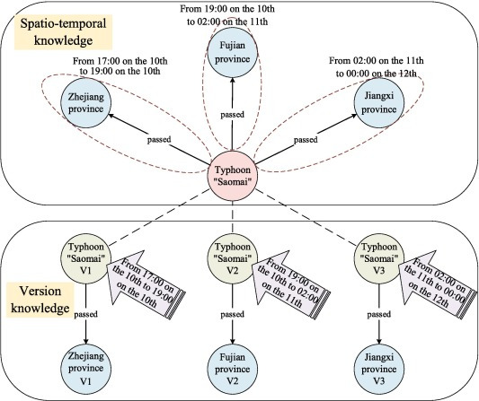
Example of a spatio-temporal knowledge graph. Source: Zhao et al.
Change detection systems are already practical and valuable. Planet’s Road & Building Change Detection feature compares repeated observations to detect new roads and buildings. The remaining gap is that change detection is usually task-specific. A spatial memory layer would be broader: it would store object identity, past states, event history, uncertainty, and context across many tasks.
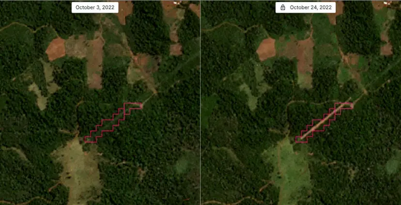
Automated identification of new road construction in Argentina by Planet
This is where long-term spatio-temporal datasets become important. Terra provides decades of hourly Earth system time series, imagery, and text. It helps address scale and temporal coverage. What remains is the architectural question: how should operational GeoAI systems write, update, query, and reason over location memory?
Building the Memory Layer
A practical spatial memory workflow could be simple.
A latest satellite image enters the system. A vision foundation model extracts features, objects, and scene descriptions. The system then retrieves relevant memory for the same location: previous observations, known objects, past events, baseline conditions, and uncertainty records.
Next, the system compares the new observation with memory. If the change looks real, the memory is updated. If the change is unclear, the system stores a low-confidence observation rather than overwriting the place record. A reasoning module then uses both the new image and the location memory to support a decision.
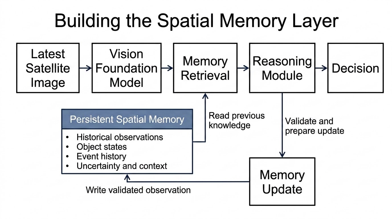
This structure matters because it separates seeing from remembering. The foundation model reads the latest image. The memory layer stores what is already known. The reasoning module decides what the change means.
Geospatial-Temporal Sensemaking moves in this direction by treating fixed construction sites as evolving targets across time. Its SMART-HC-VQA dataset uses Sentinel-2 imagery, construction phases, metadata, and question-answer pairs to reason about site activity and progression. What it solves is temporal reasoning over activity sequences. What remains is the broader memory layer that can persist across many places, tasks, sensors, and years.
Open Research Challenges
A spatial memory layer is not easy to build. Several problems remain open.
The first is memory compression. The system cannot store every pixel forever in active memory. It must decide what to summarize, what to keep, and what to forget.
The second is continual learning. The Earth changes constantly, but the model should not overwrite old knowledge too quickly. It must learn new patterns without forgetting useful historical baselines.
The third is uncertainty propagation. If an observation was affected by clouds, haze, sensor noise, or poor viewing angle, that uncertainty should remain attached to the memory record. Otherwise, the system may treat weak evidence as truth.
The fourth is scalable geo-indexing. A global memory layer must retrieve the right information for a location quickly across billions of observations, objects, and events.
The fifth is conflict handling. Different sensors, models, or human analysts may disagree. A useful memory layer must store disagreement, not hide it.
These challenges are why spatial memory should be treated as an open research direction, not as a solved feature.
The next bottleneck in geospatial AI may not be sharper imagery or larger models. It may be the ability to maintain reliable knowledge through time.
Persistent spatial memory could help GeoAI move from detecting change to understanding the long-term evolution of places. It would not replace temporal models, retrieval systems, knowledge graphs, or world models. It would connect them around a shared question: what do we know about this location, and how has that knowledge changed?
True geospatial intelligence is not only about observing the Earth. It is also about remembering it.



#Contributing Writers



Next article
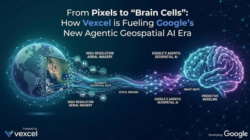

There’s a phrase that’s been rattling around the industry for years: “deriving insights from imagery.” We’ve seen it in keynotes, in pitch decks, in white papers. For the longest time, it meant that either an expert was looking at images to derive those insights or using machine learning models to derive it for others to digest.
That may finally be changing. A recent announcement from Google, the launch of Aerial and Satellite Insights under its Imagery Insights portfolio, built in partnership with Vexcel and Airbus is one of the clearest signals yet that we’re crossing a genuine inflection point.

Vexcel’s AI-powered semantic search interface lets users query real-world features in plain language. (Source: Vexcel)
I had the chance to sit down with Erik Jorgensen, Chairman and CEO of Vexcel, to dig into what this partnership actually means not just for Vexcel, but for the broader community. Here’s what stood out.
We’ve Been Calling It “Geospatial AI” for Years. This Is Different.
Here’s something Erik said that stuck with me. As an industry, we’ve been throwing around the term “Geospatial AI” for years but if we’re honest, most of what we meant was machine learning and computer vision. Companies would pick a vertical, define a set of real-world attributes (roof material, swimming pools, trampolines), label tens of thousands of examples, and train a model to find those specific things. Powerful, but narrow.
What’s happening now is a different animal entirely. The idea is that instead of pixels, you’re generating something closer to brain cells, a vectorised, semantically-rich representation of the real world that an AI engine can actually reason against. And that changes the fundamental question from “what has the model been trained to find?” to “what do you want to know?”
Think of it as Control+F for the physical world. Using zero-shot and open vocabulary analysis, you can now ask an AI agent to find “all wind turbines in this region” or locate “a river running through a city centre” without any prior training; just a plain-language description. Semantic change detection becomes possible too: distinguishing a long-standing factory from a newer one, or tracking a project from pre-construction through active build phases. We’ve been talking about this kind of capability for decades. It is genuinely starting to exist now.
This isn’t a conceptual idea anymore, by enabling natural language queries against high-resolution imagery, Vexcel has effectively commercialized this “Control+F for the physical world” paradigm for its users (Read more).
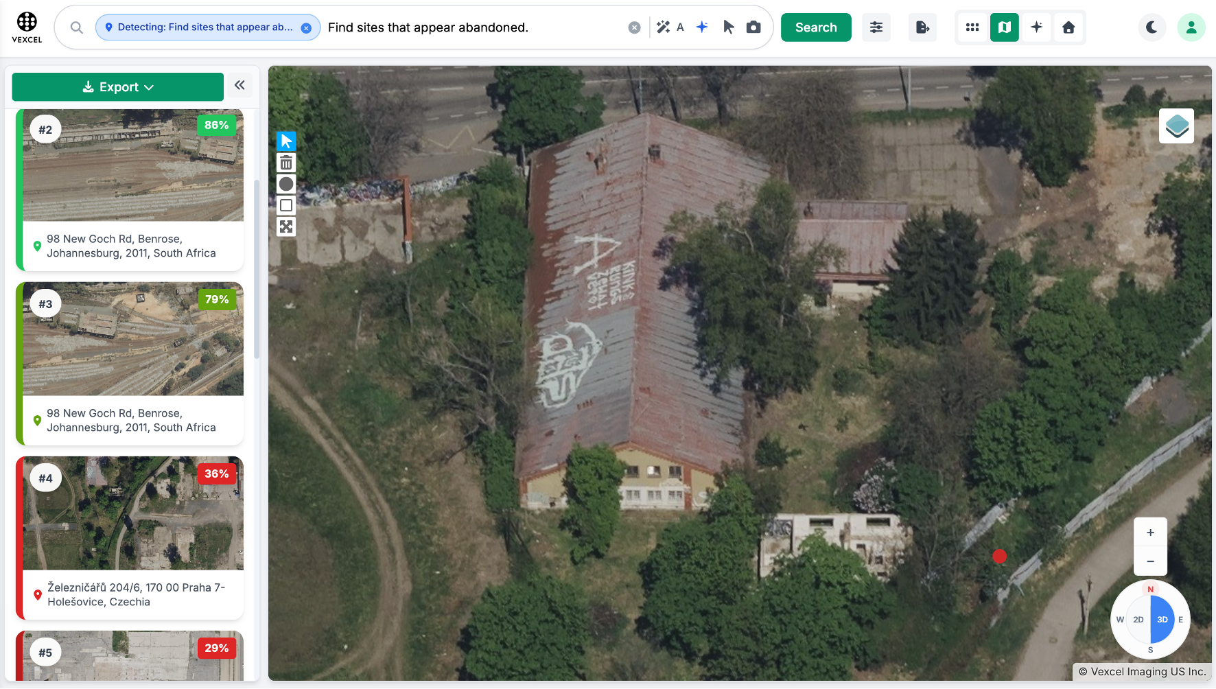
A plain-language query for “sites that appear abandoned” returns ranked, confidence-scored results — no training data required. (Source: Vexcel)
Erik gave me a real-world example that I thought was particularly compelling. Traditionally, when a major natural event happens (a hurricane, a flood) teams run computer vision classifiers against build structures to identify damage. Useful, but you’re limited to what the model was trained to see. In today’s world of agentic AI, you can ask “show me all road debris blocking transportation routes” without any prior training at all. Recovery teams get deployed faster. The same logic applies to a utility running an agentic AI across thousands of cooling towers looking for signs of corrosion or rust that used to require expensive on-site surveys.
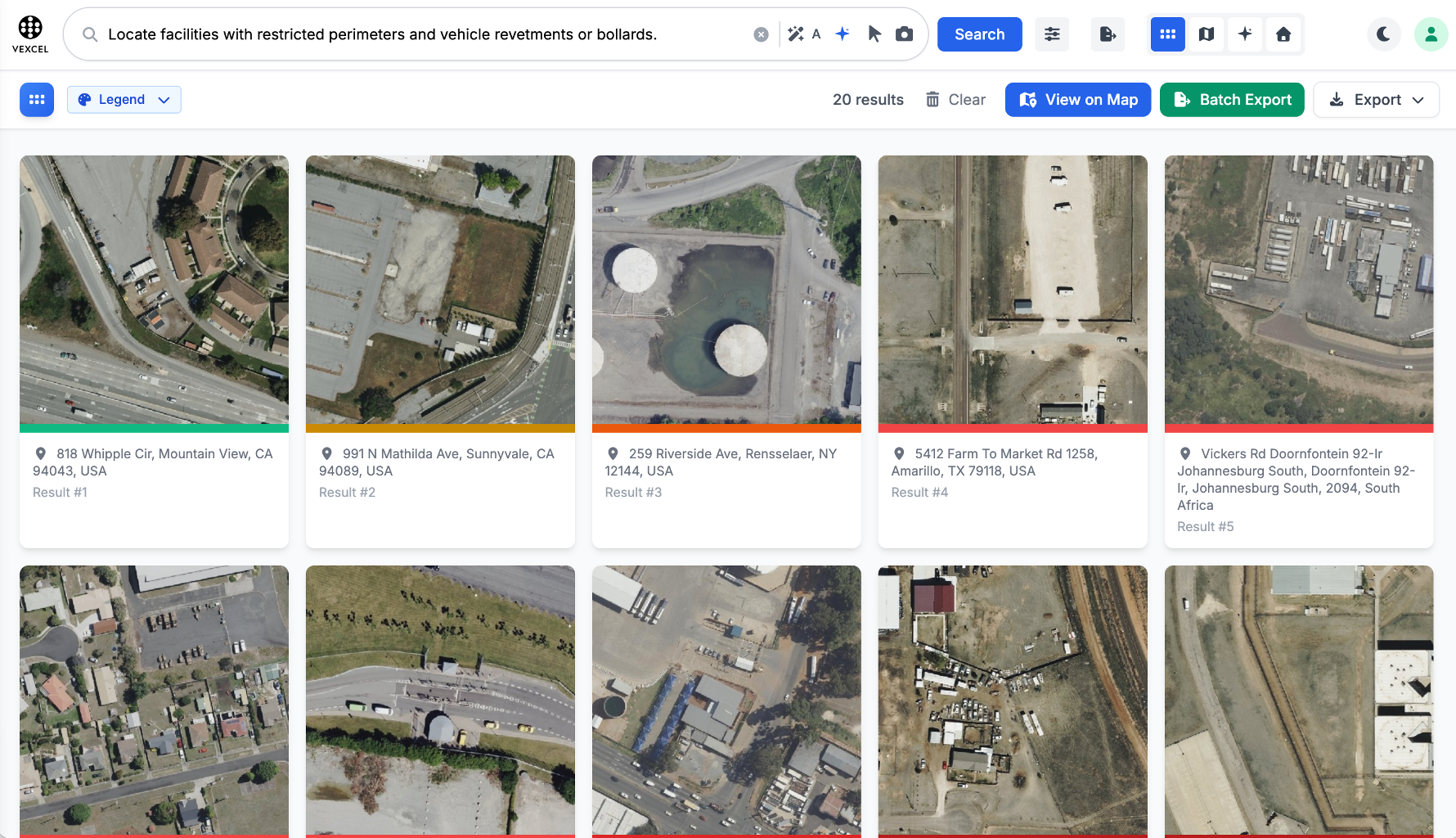
A single natural-language query surfaces dozens of matching facilities across locations — the same logic that lets an agent scan thousands of assets at once. (Source: Vexcel)
That’s not an incremental improvement. That’s a different world.
Of course, the underlying data challenge remains a hurdle that requires addressing, and we’ll dive into that exact topic in the following section.
Why the Data Underneath This Matters Enormously
None of this works without reliable ground truth. And this is where I think Vexcel’s positioning is genuinely interesting because they’re not just a data company, they’re a hardware company. They design and manufacture their own sensor systems, which means the imagery they collect in Cape Town or Rio de Janeiro is spectrally and geometrically consistent with what they’re collecting in Berlin or Washington, D.C. That global consistency is what makes it trustworthy fuel for AI reasoning at scale.
There’s also a metadata dimension to this that often gets underplayed. Knowing when the data was collected is not a nice-to-have. An insurance underwriter doing a risk assessment cannot be making decisions based on imagery that’s two years old. Timestamps, provenance, consistency these are the guardrails that prevent an AI from hallucinating against the physical world.
Erik was also clear about something I think is worth spelling out: the remote sensing ecosystem doesn’t have one winner here. Drones are great for small-area, high-frequency monitoring e.g daily progress tracking on a construction site. Satellites dominate where you need planetary-scale coverage like tracking deforestation in the Amazon. Vexcel’s fixed-wing aerial program sits squarely in the middle: the coverage breadth you’d need to map an entire continental road network for autonomous vehicle development, at the resolution you’d actually need to reason against it. Different tools, different jobs.
There’s a Model Garden Now And It Works on Your Data Too
One detail in Google’s announcement that I think deserves more attention: the launch of Aerial and Satellite Models (Experimental) within Google Cloud’s Model Garden, developed through Google Research’s Remote Sensing Foundation effort.
The key point here is that these models are not restricted to Google’s own imagery catalog. Enterprises can bring their own proprietary aerial or satellite data and apply Google’s advanced AI to extract insights from imagery they already own then there is no need to build or maintain complex models from scratch. For any organisation sitting on years of accumulated aerial surveys, that’s a significant unlock that most people haven’t quite processed yet.
Solar Insights: This Is What Problem-First Geospatial Looks Like
One of the announcements in Google’s blog that caught my attention immediately was Solar Insights (Experimental): a high-resolution, per-building solar potential dataset covering over 90% of buildings in the US and Europe. It integrates roof statistics, existing solar array data, and weather models to predict rooftop solar contributions at the building level.
This is exactly the kind of thing we started Geoawesome to talk about. The Milken Institute’s Community Infrastructure Center is already using it to assess rooftop solar potential for community resilience centers e.g. libraries, schools, clinics and layering it with climate risk and demographic data to identify where investments matter most in underserved communities. Director Rachel Halfaker described it as being able to evaluate solar potential for any community anchor facility in minutes. That’s geospatial technology solving a real problem for real people.
LiDAR Street Insights
Google is also adding LiDAR data to Street View Insights, enabling precise measurements — utility pole heights, overhead line clearances, road sign dimensions through natural language queries, all without leaving your desk.
I mentioned to Erik that I’d recently spoken with a German utility company still flying helicopters with complicated sensor payloads to monitor their infrastructure. The regulatory environment for drones hasn’t caught up yet, which I get. But the combination of tools like Street View Insights with LiDAR, alongside the kind of consistent aerial data Vexcel provides, is rapidly making the helicopter approach look like something from another era. The question is whether those companies know it yet.
Where Things Are Heading: AI Marketplaces and the End of Ortho-Only
When I asked Erik where the next two to three years take us, he flagged two things.
First: the push toward 360-degree vantage points. Most historical analytics have been built on ortho mosaics because they were simply the easiest format to work with. But AI can now reason against multi-vantage-point data; oblique views, vertical views, all of it vectorised and processed simultaneously. You’re not just seeing the AC units on the rooftop anymore; you see the whole building from every angle. Sensor innovation will follow that capability.
Second: the explosion of AI marketplaces. The model is shifting from “download data, build a pipeline” to agent-to-agent interfaces where an enterprise gets a direct answer to a complex question without ever touching a pixel. That’s a fundamental shift in who the customer is and what they’re buying and it drives a move toward token-based or value-based pricing rather than data-by-the-square-kilometre. Vexcel is leaning into this with active engagement in the Overture Maps Foundation and integration with BigQuery and Earth Engine to make their data accessible across enterprise platforms.
The Awareness Problem Is Still the Hardest Problem
Here’s the part of the conversation that I find most grounding. Vexcel just launched in India and Mexico, bringing their footprint to 47 countries. There are still regulatory challenges in some markets; certain governments restrict aerial imagery collection in ways that end up isolating them from the benefits of global AI platforms.
Erik made a point at the Geospatial World Forum in Amsterdam recently that I thought was well put: you can have sovereignty over your destiny without requiring proprietary data that locks out global participants. Countries that restrict access end up being only as capable as their own domestic geospatial industry which may be exactly the opposite of what they want.
But honestly, the biggest friction isn’t regulatory. It’s awareness. Having previously worked for a public sector transportation company, I know firsthand how difficult it is to change established business logic, even when a new approach could save millions. Many organisations still don’t know that a consistent, high-resolution aerial imagery library exists off the shelf. They assume it’s too expensive, can’t find it, or just keep doing what they’ve always done because the process works well enough and nobody has ever shown them there’s a better way (one that actually works for their problem).
Erik’s example of being able to instantly map spare railroad ties along a rail corridor — something the railways apparently don’t even have as a clean vector dataset today — and how easy and cheap that now is with agentic AI? That landed for me. That’s not science fiction. That’s today. And most of the potential customers don’t know it yet.
That’s also why partnerships like the one with Google matter so much strategically. Google has the reach and the distribution to put these capabilities in front of enterprise customers who would never go looking for a specialised aerial imagery provider on their own. As Erik put it in Google’s announcement:
“Google brings world-class expertise in geospatial technology and AI that is also opening the door to a broader set of non-technical, non-geospatial users.”
That’s the whole game.
And the awareness problem? At Geoawesome, helping close that awareness gap is exactly what we’re here to do. Let’s do it together!


