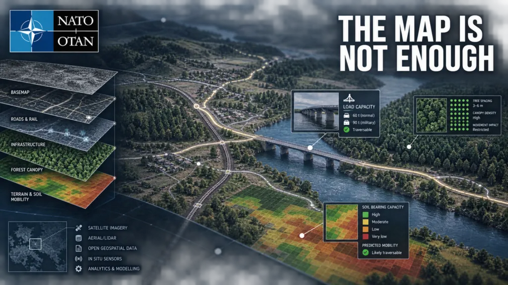

NATO is testing the market for something more demanding than another global map. A new request for information from the NATO Communications and Information Agency, or NCIA, asks industry for wide-area or potentially global geospatial datasets that can support military operations. The requirements reveal what operational geospatial data looks like when a map must inform whether a force can cross a bridge, move through a forest or reroute around damaged infrastructure.
The request, RFI-191786-GEOOPS, is market research rather than a tender or contract award. Responses are due on 22 September 2026, and only companies from NATO member countries may participate. Still, it provides an unusually detailed signal about the Alliance’s future data needs.
From basemaps to operational decisions
NCIA identifies three priority areas: soil, transportation and land cover, particularly forest characteristics.
For soil, NATO is looking for seamless global or wide-area information comparable with 30-metre resolution. The transportation requirement goes much further than ordinary road geometry. It asks about military load classifications, road clearance, surface and subgrade strength, bridge condition, rail loading gauges, staging facilities and connections between road, rail, air and maritime networks.
Forest data is expected to describe not only land-cover classes but physical characteristics such as tree type, stem spacing, trunk diameter, branch height and canopy closure. Those attributes can help assess whether terrain can be crossed or bypassed.
For every proposed dataset, vendors must explain provenance, update cycles, coverage, production time, quality assurance, metadata, attribute schemas and compatibility with NATO’s CoreGIS environment. They must also price two licensing models: use within the NATO enterprise, and broader use by NATO nations and approved non-NATO entities.
That list is strategically important. It shows that the difficult part is not simply acquiring imagery or vector geometry. NATO wants data that is current, attributable, interoperable and legally deployable across a multinational organization.
A two-layer procurement strategy
The RFI sits alongside a separate NCIA procurement for a Global Seamless Vector Basemap Data Package. That planned contract, valued at an estimated €3.5 million, is expected to deliver a foundation compliant with the NATO Geospatial Information Framework, with a solicitation planned for October 2026.
Together, the two initiatives suggest a layered approach. One procurement establishes a common reference map. The other explores operational attributes that can turn that foundation into a decision-support system.
Civilian global datasets only solve part of the problem. Overture Maps provides an open global transportation graph derived mainly from OpenStreetMap and enhanced with TomTom and other sources. ESA WorldCover offers global land-cover mapping at 10 metres. ISRIC’s SoilGrids maps fourteen soil properties worldwide, but at 250-metre resolution.
These resources could contribute to a solution, but none provides the entire package requested by NATO. A road centreline is not the same as a verified route for a particular vehicle. A forest class does not reveal trunk spacing or the clearance beneath branches. A global soil model may be too coarse for local mobility decisions. Commercial vendors may therefore compete not only on coverage, but on their ability to fuse open, national and proprietary sources into a defensible operational product.
The real competition is data governance
Likely suppliers span several parts of the geospatial market: commercial basemap and navigation providers, satellite operators, terrain and land-cover specialists, defence intelligence contractors and companies that curate national data into global products. NCIA does not name bidders, and the RFI does not establish that any particular company can meet the requirement.
The advantage may be less about owning one exclusive dataset and more about maintaining a reliable supply chain. Vendors must show how features were produced, checked and licensed for redistribution across the Alliance.
That challenge becomes sharper during a crisis. Commercial data can be highly current, but licenses designed for one enterprise may not permit rapid sharing with 32 allies or partner organizations. National authoritative data can be more detailed, but schemas, classifications and release rules vary. Open datasets offer scale and transparency, but completeness and update consistency are uneven.
NATO is confronting the same problem that many large geospatial organizations face, only with higher consequences: the map is useful only when users can trust both the feature and the permission to use it.
Part of a wider data transformation
The procurement also aligns with NATO’s Alliance Data Sharing Ecosystem. During Bold Quest 2026, five nations tested exchanging data through the developing platform. NATO says the work exposed barriers involving quality, access and speed.
That context makes the RFI more than a search for another supplier. It is an attempt to define the information layer on which future analytics, logistics planning and AI-supported workflows may depend.
Important questions remain unanswered. NCIA has not disclosed a budget, acquisition timetable or accuracy thresholds for the operational datasets. It is also unclear how frequently critical infrastructure attributes must be refreshed, how disputed observations will be resolved, and how data will be protected in disconnected or contested environments.
But the direction is clear. NATO does not merely want a digital representation of the world. It wants geospatial information that can explain what forces can do in that world, with provenance, licensing and interoperability strong enough for multinational operations.



#Business
Next article

South Korean mobile operator Stage Five is acquiring indoor location intelligence company Loplat through a comprehensive share exchange.
Under the September 2 announcement, Loplat will become a Stage Five subsidiary while retaining its existing business structure. The valuation, exchange ratio and resulting ownership distribution were not disclosed.
Stage Five says it intends to integrate Loplat’s capabilities with its Pindirect mobile service and develop new location-data businesses. The deal is therefore more than an indoor-navigation acquisition: it brings together a mobile customer relationship, AI-enabled telecom operations and behavioural location intelligence.
Loplat identifies visits to indoor places mainly by comparing nearby Wi-Fi signals with an existing fingerprint database. Its technology documentation describes a combination of Wi-Fi fingerprinting, IP-based location and Wi-Fi positioning that can recognize individual stores or building floors without dedicated positioning hardware at every venue.
The company says its database includes more than 100 million Wi-Fi access points and at least 600,000 indoor points of interest, while its current website advertises more than 700,000 POIs. These figures have not been independently audited.
Applications include retail footfall measurement, location-based marketing and digital-out-of-home advertising analysis. Wi-Fi fingerprinting can reuse existing infrastructure, reducing deployment costs compared with systems requiring specialist anchors or tags.
However, “hardware-free” does not mean maintenance-free. Routers move, stores relocate and network identifiers change. Loplat’s documentation acknowledges that fingerprint databases require periodic updates. Mobile operating-system restrictions can also affect what signals are available.
Stage Five operates the Pindirect MVNO and is building Stage-On, an AI-native telecom platform covering customer onboarding, billing, service and operations. The company reported 2025 revenue of KRW111.2 billion, up 282%, alongside a small operating loss, figures also covered by the Seoul Economic Daily.
Owning Loplat could help Stage Five differentiate itself through mobility analysis, local services and commercial footfall products. In principle, it could connect audience analysis, customer engagement and visit measurement. That is a potential strategic direction, not a confirmed product roadmap.
The unanswered question is whether Stage Five plans to combine Loplat observations with telecom subscriber information. The acquisition announcement does not describe the future data architecture.
That distinction matters because location histories can reveal homes, workplaces, health visits and religious practices even when names are removed. The companies should explain how consent works, whether subscriber and SDK data will be linked, how long signals are retained and how sensitive destinations are protected.
Loplat competes with IndoorAtlas, Pointr, Mapsted, Oriient and Bluetooth- or UWB-based positioning providers. Its likely advantage is the scale of its existing fingerprint database rather than centimetre-level accuracy.
The acquisition gives Stage Five a potentially valuable location asset. Its commercial defensibility will depend on database quality and telecom distribution. Its legitimacy will depend on transparent consent, strict data separation and users’ ability to control their information.


