

Stellaria has raised AED25 million, approximately $6.8 million, from unnamed angel investors. The round values the UAE geospatial AI company at AED420 million, or $114.4 million.
That valuation is the most striking number in the announcement. The investment represents roughly 6% of the post-money value, an unusually high price for a seed-stage company that has not disclosed revenue, major customer contracts or institutional investors.
Yet the round points to a bigger shift. Governments and investors are moving their attention from satellites alone to the software that turns imagery into operational intelligence.
From monitoring farms to sovereign intelligence
Stellaria grew out of Farmin, an agricultural monitoring venture founded by Ali AlHammadi. Its early technology applied AI to satellite imagery to identify variations in crop health, water use and productivity.
The company has since expanded into maritime surveillance, ports, infrastructure, environmental monitoring and security. Its Stella platform is presented as an operating system that combines optical imagery, radar, hyperspectral and thermal data with vessel tracking and open-source information.
This is a significant repositioning. Stellaria is no longer selling a specialized agricultural application. It is trying to become the reasoning layer between multiple Earth observation sources and high-value government or commercial decisions.
Geoawesome previously examined one part of that strategy in How UAE Startup Stellaria Is Taking EO Super-Resolution to the Next Level. That article explored Meruem, Stellaria’s AI model for enhancing optical, SAR and hyperspectral imagery, and the central trust problem surrounding super-resolution.
Stellaria says Meruem can enhance imagery by up to ten times while maintaining a hallucination rate below 1% and improving downstream analytics by as much as 25%. These remain company claims. No complete independent benchmark, evaluation dataset or customer validation has been published.
A market attracting serious capital
Stellaria is entering a competitive market with three distinct business models.
The first is vertical integration. Companies such as Space42 and BlackSky control both satellite capacity and the analytics software applied to the resulting data. This gives them greater control over tasking, revisit rates and delivery speed.
Space42 is Stellaria’s most important local reference point. Its Bayanat business operates the GIQ analytics platform alongside the UAE’s Foresight SAR constellation. A five-year AED378 million agreement with EDGE’s FADA gives it a powerful position in the country’s sovereign Earth observation infrastructure.
The second model is specialization. Preligens built AI systems for analyzing satellite imagery and other defense sensors before Safran acquired it for €220 million. LiveEO developed satellite analytics around infrastructure monitoring before expanding into defense and its own constellation, supported by a new investment of more than €28 million.
The third model, chosen by Stellaria, is to remain largely sensor-agnostic. Instead of financing a constellation, it can combine the most appropriate commercial and sovereign data sources for each task.
That approach reduces capital requirements and avoids dependence on one sensor. It also creates a potential role for Stellaria as a supplier to national space programs rather than simply a competitor. The challenge is defensibility: companies that do not own unique data must prove that their models, integrations and operational workflows are difficult to reproduce.
A valuation waiting for validation
Public reaction to the round has been mainly congratulatory. Regional media have focused on the size of the valuation and the UAE’s growing space ecosystem. The limited critical commentary has concentrated on the unnamed investors, absence of customer information and lack of independently tested performance figures. No substantive practitioner debate has emerged.
The broader investment pattern is clear. Capital is flowing into the layer that converts geospatial data into answers, alerts and decisions. Sovereign deployment, data provenance and integration into secure workflows are becoming as important as model accuracy.
Stellaria has secured a premium valuation for its place in that market. Its next milestone must be harder to manufacture than a funding announcement: a named operational customer, a significant contract or independently reproducible evidence that its technology improves real decisions.



#Business
Next article
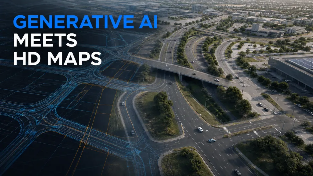
Autonomous-driving systems are increasingly evaluated through long-horizon simulation, where planning errors can accumulate across several junctions and interactions. That creates a mapping requirement that short scenario tests do not: simulators need large, connected and varied lane-level road networks.
Real-world HD maps offer geographic realism but require data collection and processing. Handcrafted simulator maps are controllable but expensive to expand. A new research framework called RoadWeaver proposes a third option: generating complete synthetic HD road networks from scratch.
The objective is not to reproduce a real city. It is to create structurally varied environments in which autonomous-driving systems can be tested beyond a limited set of familiar map assets.
From global layout to lane geometry
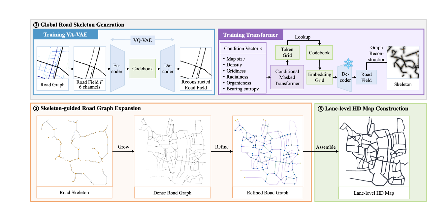
RoadWeaver follows a coarse-to-fine process. It first generates the global road layout, expands that structure into a connected road network and then creates individual lanes while maintaining valid connections between them.
This distinction between global topology and lane-level geometry is important. Existing generative approaches often work on local map patches, while procedural systems may depend on a fixed library of road components. Both can struggle to produce large networks with consistent connectivity.
RoadWeaver gives users control over map extent, target road density and aspects of road morphology. The outputs can be exported to OpenStreetMap and OpenDRIVE formats and integrated with the Tactics2D simulation platform.
ASAM OpenDRIVE describes the static elements of a road network for driving simulation, including the road geometry and related objects. Supporting an established exchange format makes the generated maps easier to use in existing testing pipelines.
Strong topology results, rapid generation
The authors evaluated RoadWeaver against other automatic map-generation methods. They report 99.8% reachability across the generated road network, a 10.7% dead-end ratio and a lane-endpoint alignment error of 0.24 metres.
The endpoint error was 94.4% lower than the comparison methods used in the study. Complete maps were generated in approximately 1.39 to 3.50 seconds, depending on their configuration.
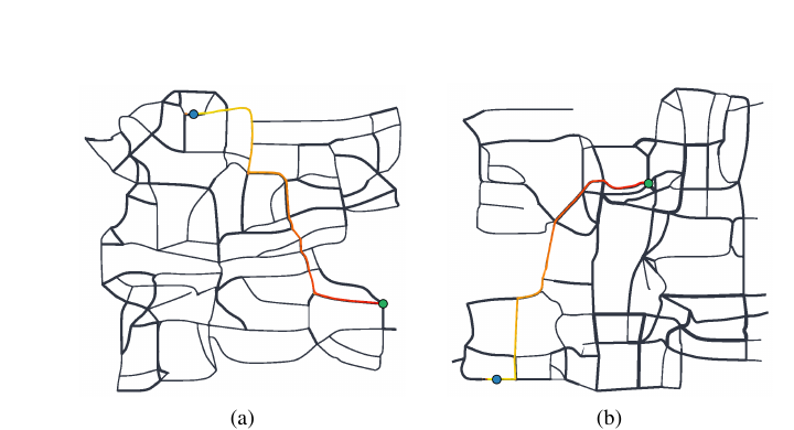
These results suggest that synthetic HD-map generation could become an inexpensive way to expand the structural coverage of simulation. Developers could vary network density, junction patterns and route length without surveying another real location or manually assembling each map.
That is particularly relevant for closed-loop evaluation. A system may perform well on isolated turns or merges but make poor lane choices several decisions before a complex junction. Large connected networks expose those dependencies more effectively than collections of short scenes.
Topological validity is not geographic realism
The reported metrics show that RoadWeaver can generate well-connected lane networks. They do not establish that every generated network reflects plausible road engineering or real-world planning.
Actual road systems are shaped by terrain, design standards, land ownership, traffic rules and historical development. A synthetic map can be geometrically valid while underrepresenting uncommon but safety-critical configurations. The usefulness of RoadWeaver will therefore depend on whether its generated diversity corresponds to meaningful operational test coverage.
The paper also reports map-generation metrics rather than evidence that the maps reveal additional autonomous-driving failures. The stronger validation would be comparative closed-loop testing: run several driving systems on generated and conventional maps, then measure whether RoadWeaver exposes new planning weaknesses.
Independent reproduction must also wait. The authors say the training code and out-of-the-box implementation will be released after acceptance.
RoadWeaver should therefore be understood as simulation infrastructure, not an alternative to surveyed HD maps used for real-world navigation. Its strategic value lies elsewhere: it makes road topology a controllable test variable.
For autonomy developers, that could expand mapping from a static prerequisite into an active part of safety evaluation—one designed to find failures rather than simply represent a known place.
How do you like this article? Read more and subscribe to our monthly newsletter!


