
For decades, the Earth Observation industry followed a simple rule: if you wanted better imagery, you launched better satellites.
Today, a growing number of companies are asking a different question: how much more value can be extracted from the data already in orbit?
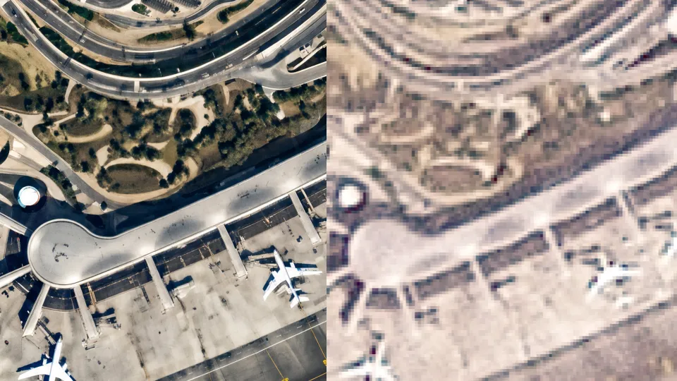
One of them is Stellaria, a UAE-based geospatial startup whose new AI model, Meruem, aims to enhance satellite imagery across optical, SAR, and hyperspectral sensors. Rather than building new satellite sensors, Stellaria is focused on improving the quality and usability of existing imagery through super-resolution technology.
The concept is attracting increasing attention across the industry. As satellite constellations generate more data than ever before, many organizations are discovering that access to imagery is no longer the main challenge. Extracting useful information from that imagery is.
From Agriculture to GeoAI
The story behind Stellaria starts long before the launch of Meruem.
The company’s roots can be traced back to Farmin, a startup founded by Ali AlHammadi in Abu Dhabi in 2019. Initially focused on agriculture, the company explored how satellite data could help farmers improve productivity, water management, and resource efficiency.
While working with satellite imagery, the team encountered a familiar challenge: the available data often lacked the level of detail required for operational decisions.
That challenge led them into AI-powered image enhancement.
What began as an agricultural use case gradually evolved into a broader geospatial intelligence platform serving sectors such as infrastructure, maritime operations, environmental monitoring, and security. Meruem appears to be the result of that journey—a product built on years of experimentation with super-resolution techniques.
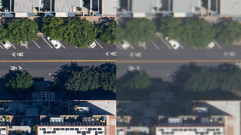
credit: Stellaria
Why Super-Resolution Matters
Earth Observation users often face a trade-off between cost and image quality. Higher-resolution imagery can be expensive, while lower-cost datasets may not provide enough detail for certain applications.
Super-resolution attempts to bridge that gap.
Using AI, these models analyze existing imagery and reconstruct additional detail, creating images that can support more accurate interpretation and analysis. The goal is not simply to create sharper pictures, but to improve the value of downstream workflows.
For mapping teams, that could mean better asset extraction and change detection. For agriculture, more precise field monitoring. For maritime operators, improved situational awareness. For disaster response teams, more useful imagery when higher-resolution data is unavailable.
The real question is not whether the imagery looks better, but whether users can make better decisions because of it.
A Growing Competitive Landscape
Stellaria is entering an increasingly crowded market.
Companies such as Maxar have already demonstrated demand for AI-enhanced imagery through products like HD imagery. Others, including Nara Space and LuxCarta, are developing their own super-resolution capabilities for mapping, GIS, and analytics applications.
What differentiates Stellaria is its ambition to position super-resolution as part of a broader geospatial intelligence platform rather than as a standalone image enhancement service. The company is also pursuing a multi-sensor approach, extending beyond optical imagery into SAR and hyperspectral data.
Whether that differentiation proves meaningful will depend on customer outcomes. Organizations are unlikely to pay for sharper images alone. They will pay if enhanced imagery improves analytics, reduces costs, or enables decisions that were previously impossible.
The Trust Challenge
Like every company working in this space, Stellaria faces a fundamental challenge: trust.
When AI adds detail to an image, users need confidence that the information reflects reality rather than assumptions made by the model.
This is particularly important in sectors such as defence, critical infrastructure, insurance, and government, where decisions can have significant operational or financial consequences.
The broader Earth Observation community is increasingly focused on issues such as transparency, auditability, provenance, and hallucinations. While Stellaria highlights quality-control mechanisms and safeguards within its processing pipeline, independent validation will ultimately matter more than company claims.
The challenge for all super-resolution providers is the same: users need confidence that AI is revealing information rather than inventing it.
A Sign of Where the Industry Is Heading
Regardless of how Meruem performs in the market, its launch reflects a broader trend within Earth Observation.
Some of the most interesting innovation is no longer coming solely from satellite operators. Increasingly, value is being created by companies building software layers on top of existing data sources.
The UAE has invested heavily in space, artificial intelligence, and geospatial technologies over the past decade. Companies like Stellaria represent a new generation of startups emerging from that ecosystem and bringing new ideas to the global market.
Meruem is one example of a much larger shift. Alongside efforts from Maxar, LuxCarta, Nara Space, and others, it reflects a growing belief that the future of Earth Observation will be shaped as much by software as by hardware.
The next phase for the industry is not about collecting more data. It is about making better use of the data we already have.

#GeoAI


Next article
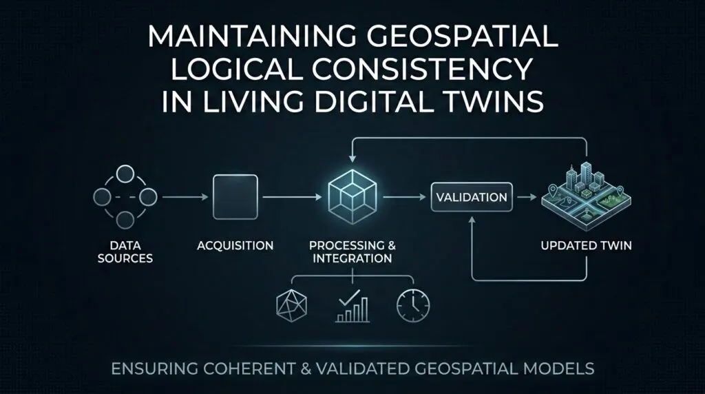
Maintaining Geospatial Logical Consistency in Living Digital Twins
Most digital twins start out being accurate, but they begin aging the moment the physical world changes.
A bridge is repaired. A road is closed. A utility line is moved. A new building appears in a satellite image. If the digital twin does not absorb these changes, it slowly becomes a reliable-looking record of the past. This is the problem with many project-based twins. They are created for a specific design, construction, or planning task, then treated as finished. The 3D model may still look impressive, but the data underneath it begins to decay.
The goal now is to move from static project twins to living digital twins. Autodesk describes digital twins as dynamic models that can evolve in real time by exchanging data with their physical counterparts. In infrastructure, this transition is already visible as digital twins move from design artifacts to tools for maintenance, inspection, and predictive planning. The market is growing rapidly, with the global digital twin market projected to increase from USD 24.48 billion in 2025 to USD 259.32 billion by 2032, reflecting a compound annual growth rate (CAGR) of 40.1%. But scale alone will not solve the problem. A living twin needs more than sensors and dashboards. It needs geospatial logical consistency.
This article looks at what that means, how autonomous conflation keeps twins aligned with the real world, why GIS teams are moving toward policy-based auditing, and how evergreen urban models can support routing, disaster simulation, and predictive maintenance.
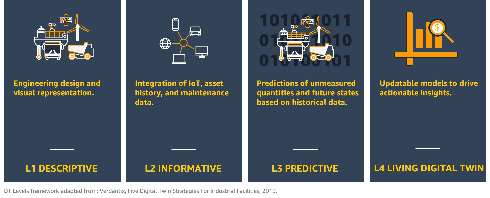 Digital Twins Levels Framework. Source: AWS
Defining Geospatial Logical Consistency
A digital twin is not useful just because it looks realistic. It also has to behave correctly.
This is where geospatial logical consistency comes in. It means the data inside the twin follows spatial rules. Roads should connect to roads. Pipes should meet at valid junctions. Buildings should not float across parcel boundaries. A bridge should cross a river, not sit beside it with no connection. In GIS, many of these rules are handled through topology. Topology defines how points, lines, and polygons share geometry, connect to each other, and maintain valid relationships. Without it, a digital twin becomes a hollow shell. It may look correct on screen, but it cannot support routing, simulation, or reliable analysis. This matters even more when updates become automated. A living twin may receive new data from drones, IoT sensors, mobile mapping systems, and satellite imagery. Each source may be useful, but each can also introduce errors.
That is why a living twin needs spatial rules as guardrails. A road cannot pass through a building without explanation. A water pipe cannot connect to an electrical cable. A new building footprint should not erase a legal boundary unless there is trusted evidence.
This connects to the wider idea of geospatial reasoning. The twin must understand relationships, not just recognize objects. Some industry discussions call this the rise of self-healing digital twins. The idea is that the system can detect inconsistent data, flag the problem, and sometimes suggest a correction.
Autonomous Spatiotemporal Conflation
A living digital twin cannot depend on one perfect dataset. It has to merge many imperfect ones.
That process is called conflation. In GIS, conflation aligns features from different geographic layers and transfers useful attributes from one layer to another. In a living twin, this becomes spatiotemporal. The system is not only asking, “Where is this feature?” It is also asking, “When was this version true?” 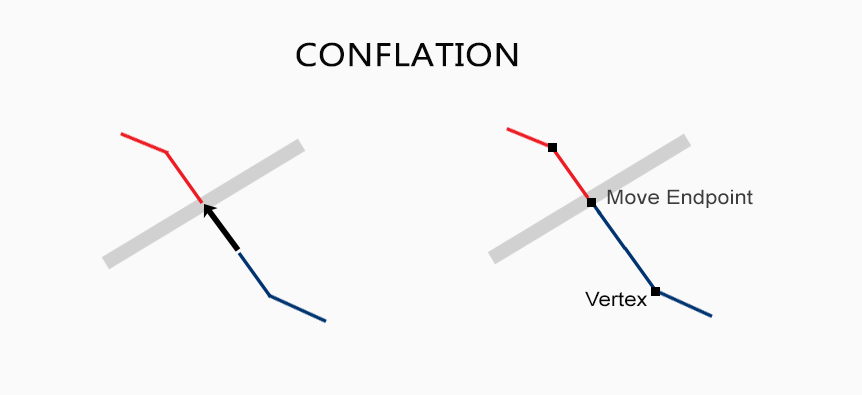
Source: GIS Geography
This matters because a city twin may contain several versions of reality at once. A legacy utility map may show where a pipe was installed years ago. A drone scan may show that the road above it has changed. An IoT sensor may show that water pressure is dropping right now. The twin has to combine these signals without creating contradictions.
This is where source authority becomes important. Not every dataset should have the same weight. A live utility sensor may be more trusted for a current outage. A cadastral layer may be more trusted for a legal boundary. A drone scan may be more trusted for recent surface damage.
The same logic appears in wider digital twin architecture. Recent discussions around federated digital twins point to shared semantics, open standards, and governance as key requirements for connecting many systems.
The Transition: From Manual Editing to Policy-Based Auditing
In a living digital twin, GIS teams cannot update every feature by hand.
The work moves from drawing data to governing data. Instead of manually digitizing every new curb, pipe, road closure, or asset change, teams define spatial policies. These policies decide what counts as a valid update, which source has priority, how topology should be preserved, and when a change needs review.
This is already part of strong GIS data management. Good spatial systems need standards, schemas, ownership, and automated quality checks so the data remains current and trustworthy.
The same idea becomes more important in living digital twins. A city twin may receive updates from road sensors, drone surveys, utility systems, and public agencies. Without clear rules, automation can create confusion instead of clarity.
This is also why sovereign data spaces matter for smart cities. They allow different agencies to share data through trusted frameworks without losing control of their own information.
As twins become more automated, the human role changes. GIS professionals become auditors. They do not check every routine update. They focus on edge cases where the system finds a conflict, uncertainty, or rule violation.
This connects to the rise of Agentic GeoAI, where systems can monitor data, run spatial operations, and suggest actions. But autonomy does not remove human judgment. It makes human judgment more targeted.
Some digital twin discussions describe this next stage as cognitive twins, where systems understand context, not just data patterns.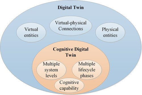
Relation between digital twin and cognitive digital twin. Source: Zheng et al.,2022
Case Study: The “Evergreen” Urban Model
An evergreen urban model is a city-scale digital twin that does not wait for a yearly update. It updates through repeated healing cycles.
The cycle is simple. New data arrives from drones, sensors, permits, field teams, satellites, or connected infrastructure. The twin compares that data with its trusted base layers. If the change follows the rules, the model updates. If it creates a conflict, the system flags it for review. This is how a city twin stays alive.
Virtual Singapore is an early example of this direction. It is a detailed 3D model that supports simulations and virtual testing for urban planning. Other sources describe its use for flood analysis, solar panel opportunities, green roofs, and wind impact studies.
Helsinki shows the climate side of the same idea. Its city-scale digital twin supports sustainability and quality-of-life work, while the Energy and Climate Atlas helps model building-level energy consumption for carbon-neutral planning.
The value becomes even clearer during disasters. In Cauayan City, Philippines, a digital twin built from drone imagery has been used to assess damage to houses, crops, infrastructure, and livestock after storms.
Smart mobility is another downstream benefit. Las Vegas has explored a digital twin that collects data on mobility, traffic, air quality, noise, and emissions to test future city scenarios.
In all these cases, the twin is useful because it keeps moving with the city. The goal is not just a better 3D model. It is a trusted operational layer for routing, climate planning, disaster response, and maintenance.
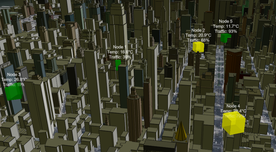
Try it yourself: a simple living digital twin in Cesium
To make this idea easier to understand, you can run a small example of a city digital twin in your browser.
First, open Cesium Sandcastle at https://sandcastle.cesium.com/ and go to the code editor. Copy and paste the code below and run it.
This example creates a small network of sensor nodes placed in a 3D city. Each node simulates changing local conditions such as temperature and traffic. The camera then focuses on the centre of all nodes, so you can see the whole system as one connected area.
What this shows is the basic idea behind a living digital twin: multiple spatial points updating together inside a consistent geospatial space.
import * as Cesium from "cesium";

// Viewer setup
const viewer = new Cesium.Viewer("cesiumContainer", {
  terrain: Cesium.Terrain.fromWorldTerrain(),
});

// OSM Buildings
const osmBuildingsTileset = await Cesium.createOsmBuildingsAsync();
viewer.scene.primitives.add(osmBuildingsTileset);

// Sensor positions [lon, lat]
const sensorPositions = [
  [-73.9857, 40.7484],
  [-73.9810, 40.7495],
  [-73.9900, 40.7470],
  [-73.9835, 40.7435],
  [-73.9785, 40.7505],
];

// Create sensor entities
const sensors = [];

function createSensor(lon, lat, i) {
  return viewer.entities.add({
    position: Cesium.Cartesian3.fromDegrees(lon, lat, 80),
    box: {
      dimensions: new Cesium.Cartesian3(40, 40, 40),
      material: Cesium.Color.CYAN.withAlpha(0.9),
    },
    label: {
      text: `Node ${i + 1}`,
      font: "14px sans-serif",
      fillColor: Cesium.Color.WHITE,
      pixelOffset: new Cesium.Cartesian2(0, -40),
    },
  });
}

sensorPositions.forEach((p, i) => {
  sensors.push(createSensor(p[0], p[1], i));
});

// Compute centroid in world space
const cartesianPoints = sensorPositions.map(p =>
  Cesium.Cartesian3.fromDegrees(p[0], p[1])
);

let centroid = cartesianPoints.reduce(
  (acc, p) => Cesium.Cartesian3.add(acc, p, new Cesium.Cartesian3()),
  new Cesium.Cartesian3()
);

centroid = Cesium.Cartesian3.multiplyByScalar(
  centroid,
  1 / cartesianPoints.length,
  new Cesium.Cartesian3()
);

// Camera focus on centroid
viewer.scene.camera.lookAt(
  centroid,
  new Cesium.Cartesian3(0.0, 0.0, 1500)
);

// Simulation loop — updates every 1.2 s
setInterval(() => {
  sensors.forEach((sensor, i) => {
    const temp      = 10 + Math.random() * 25;
    const traffic   = Math.random() * 100;
    const intensity = temp + traffic / 6;

    sensor.box.material =
      intensity < 30 ? Cesium.Color.GREEN.withAlpha(0.9)
    : intensity < 45 ? Cesium.Color.YELLOW.withAlpha(0.9)
    :               Cesium.Color.RED.withAlpha(0.9);

    sensor.label.text =
      `Node ${i + 1}\nTemp: ${temp.toFixed(1)}°C\nTraffic: ${traffic.toFixed(0)}%`;
  });
}, 1200);
The visualisation will look like this:
A living digital twin is not defined by how detailed it looks. It is defined by how much it can be trusted.
That trust depends on consistency. Roads must connect, assets must update, and conflicts must be traceable. When the world changes, the twin must know what changed, which source to trust, and when a human should step in.
This is why geospatial logical consistency is becoming central to the future of digital twins. It turns the twin from a static model into a reliable operational layer.
Did you like this article? Read more and subscribe to our monthly newsletter!

