

Autonomous-driving systems are increasingly evaluated through long-horizon simulation, where planning errors can accumulate across several junctions and interactions. That creates a mapping requirement that short scenario tests do not: simulators need large, connected and varied lane-level road networks.
Real-world HD maps offer geographic realism but require data collection and processing. Handcrafted simulator maps are controllable but expensive to expand. A new research framework called RoadWeaver proposes a third option: generating complete synthetic HD road networks from scratch.
The objective is not to reproduce a real city. It is to create structurally varied environments in which autonomous-driving systems can be tested beyond a limited set of familiar map assets.
From global layout to lane geometry
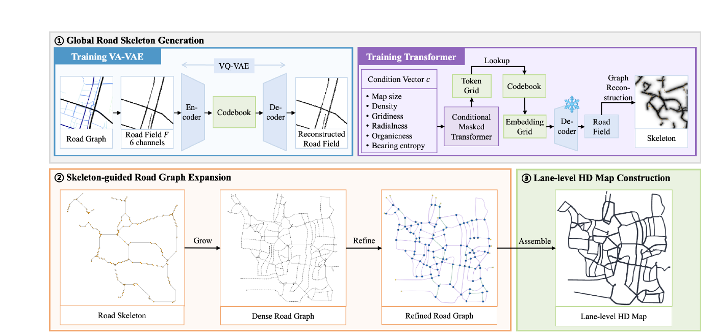
RoadWeaver follows a coarse-to-fine process. It first generates the global road layout, expands that structure into a connected road network and then creates individual lanes while maintaining valid connections between them.
This distinction between global topology and lane-level geometry is important. Existing generative approaches often work on local map patches, while procedural systems may depend on a fixed library of road components. Both can struggle to produce large networks with consistent connectivity.
RoadWeaver gives users control over map extent, target road density and aspects of road morphology. The outputs can be exported to OpenStreetMap and OpenDRIVE formats and integrated with the Tactics2D simulation platform.
ASAM OpenDRIVE describes the static elements of a road network for driving simulation, including the road geometry and related objects. Supporting an established exchange format makes the generated maps easier to use in existing testing pipelines.
Strong topology results, rapid generation
The authors evaluated RoadWeaver against other automatic map-generation methods. They report 99.8% reachability across the generated road network, a 10.7% dead-end ratio and a lane-endpoint alignment error of 0.24 metres.
The endpoint error was 94.4% lower than the comparison methods used in the study. Complete maps were generated in approximately 1.39 to 3.50 seconds, depending on their configuration.
These results suggest that synthetic HD-map generation could become an inexpensive way to expand the structural coverage of simulation. Developers could vary network density, junction patterns and route length without surveying another real location or manually assembling each map.
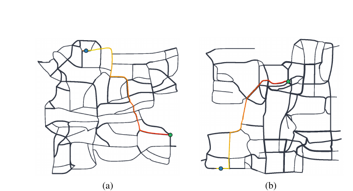
That is particularly relevant for closed-loop evaluation. A system may perform well on isolated turns or merges but make poor lane choices several decisions before a complex junction. Large connected networks expose those dependencies more effectively than collections of short scenes.
Topological validity is not geographic realism
The reported metrics show that RoadWeaver can generate well-connected lane networks. They do not establish that every generated network reflects plausible road engineering or real-world planning.
Actual road systems are shaped by terrain, design standards, land ownership, traffic rules and historical development. A synthetic map can be geometrically valid while underrepresenting uncommon but safety-critical configurations. The usefulness of RoadWeaver will therefore depend on whether its generated diversity corresponds to meaningful operational test coverage.
The paper also reports map-generation metrics rather than evidence that the maps reveal additional autonomous-driving failures. The stronger validation would be comparative closed-loop testing: run several driving systems on generated and conventional maps, then measure whether RoadWeaver exposes new planning weaknesses.
Independent reproduction must also wait. The authors say the training code and out-of-the-box implementation will be released after acceptance.
RoadWeaver should therefore be understood as simulation infrastructure, not an alternative to surveyed HD maps used for real-world navigation. Its strategic value lies elsewhere: it makes road topology a controllable test variable.
For autonomy developers, that could expand mapping from a static prerequisite into an active part of safety evaluation—one designed to find failures rather than simply represent a known place.
How do you like this article? Read more and subscribe to our monthly newsletter!