

Allied Orbits Is Taking a $145M Bet on India’s EO Data Market
India’s first privately led national Earth observation constellation is often described as a ₹1,200-crore public-private partnership. The most important word in that description may be “private.”
The Allied Orbits consortium—Pixxel, Dhruva Space, PierSight and SatSure—will design, build, own and operate twelve satellites. It will also finance the project itself.
A February 2026 answer from India’s Press Information Bureau lists the government project value as “Nil”. Indian business reporting described the winning offer as a zero-cost bid: the consortium will invest more than ₹1,200 crore, roughly $140–145 million, rather than receive that amount from the state.
That makes Allied Orbits less like a conventional government contractor and more like a privately financed infrastructure operator with a strategically important customer channel.
What the government is—and is not—buying
IN-SPACe selected the Pixxel-led team in August 2025, and the consortium formalized the agreement in January 2026. The government will coordinate access for Indian public-sector users and help bring demand into the system. Allied Orbits can commercialize the data globally.
The consortium retains ownership of the satellites and data infrastructure. That creates upside if it builds a valuable service, but it also shifts financing, deployment and demand risk away from the government.
Public documents do not disclose a minimum purchase commitment, guaranteed government revenue or detailed pricing structure. Industry discussion has consequently focused on launch costs, the depth of domestic demand and the time required to turn a multimodal fleet into commercially useful products. Access to government customers is valuable; it is not the same as contracted offtake.
Twelve satellites, four sensor markets
The approved architecture is unusually broad. A recent parliamentary response describes five ultra-high-resolution optical satellites with four spectral bands, three multispectral satellites with eight bands, two hyperspectral satellites with 250 bands and two X-band SAR spacecraft.
The design gives Allied Orbits access to several markets: detailed mapping, agriculture, resources, maritime awareness, infrastructure, environmental monitoring and national security. It also creates four different product and competition problems.
In high-resolution optical imagery, global buyers already have access to Maxar, Planet, BlackSky and Satellogic. Commercial SAR is led by specialists such as ICEYE, Umbra and Capella. Hyperspectral operators include Pixxel itself and emerging rivals such as Wyvern and Orbital Sidekick. Indian customers can also draw on established ISRO missions and public data programs.
Allied Orbits therefore cannot compete simply by being another image supplier. Its advantage must come from sovereign access, coordinated tasking, integrated products and local analytics.
That is why the consortium structure matters. Pixxel brings hyperspectral spacecraft and the Aurora data platform. PierSight focuses on maritime SAR. Dhruva Space contributes spacecraft and mission infrastructure. SatSure provides downstream analytics and established relationships in sectors such as agriculture and financial services.
On paper, this is a vertically integrated value chain. In practice, combining different sensors into consistent analysis-ready products is difficult. Calibration, revisit, cloud cover, tasking priorities, licensing and latency must be managed across the fleet. The ₹1,200-crore figure also covers more than spacecraft manufacturing, so dividing it by twelve does not produce a meaningful satellite unit cost.
The competitive process was real
Allied Orbits did not receive the opportunity by default. IN-SPACe says the final competition included an Astra Microwave-led group with Bharat Electronics, Sisir Radar and SpectraGaze, plus a GalaxEye–CoreEL team. Earlier reporting indicated a broader field that included major industrial names and multiple startup consortia.
The structure maximizes private investment and minimizes direct public expenditure. For the operator, however, economics depend on utilization. Satellite data has high fixed costs and low marginal distribution costs: profitability improves if captures support multiple customers and analytics raise their value, but deteriorates if capacity arrives before repeat demand.
This is a familiar commercial-EO challenge. Imagery supply has expanded faster than many customers’ ability to integrate it, so the strongest businesses increasingly sell monitoring, alerts and decisions rather than raw pixels.
Allied Orbits seems to understand that, promising analysis-ready data and value-added services rather than only imagery. The unresolved question is how revenue and responsibilities will be divided among four companies whose existing products overlap some parts of the new system.
A sovereign platform with commercial pressure
Strategically, the model is significant. India wants domestic control over important EO infrastructure without returning to an exclusively state-built approach. Allied Orbits gives private firms ownership and global commercialization rights while reserving a coordinated route for national needs.
Commercially, it is a demanding bargain. The consortium receives validation, market access and a national platform—but not a ₹1,200-crore government cheque.
If it succeeds, India will have created a template for sovereign geospatial capacity financed by downstream demand. If it struggles, the lesson may be that data sovereignty and commercial bankability are different objectives.
Allied Orbits now has to prove they can reinforce each other.
Sources: Pixxel agreement announcement; PIB statement confirming nil government project value; Economic Times on private financing; Economic Times on the winning consortium; ISRO annual report.
How do you like this article? Read more and subscribe to our monthly newsletter!



#Business
Next article

Machine Unlearning in GeoAI: Can Models Forget What They Learned About a Place?

Imagine that years of location data from thousands of people are used to train a mobility model. The model learns common commute routes, busy roads, frequently visited neighbourhoods, and broader travel patterns. Later, one person deletes their location history and asks that their information no longer be used.
Removing the original records from a database may be straightforward. But those records have already influenced the model during training. Deleting the data does not automatically reverse what the model learned.
This raises a difficult question: has the information actually disappeared, or does some of its influence remain inside the model? Machine unlearning aims to remove the contribution of selected training data from an existing model without rebuilding it completely. The challenge is to remove the requested influence while preserving useful knowledge learned from the remaining data.
Geographic information makes this harder because observations are connected through space and time. One person’s route may also contribute information about road use, travel times, and neighbourhood activity. Spatio-temporal graph unlearning shows that this problem is beginning to be studied in dynamic, interconnected data.
This article looks at why geographic information is difficult to forget, what GeoAI may need to unlearn, and how we can test whether a model has truly removed the requested influence.
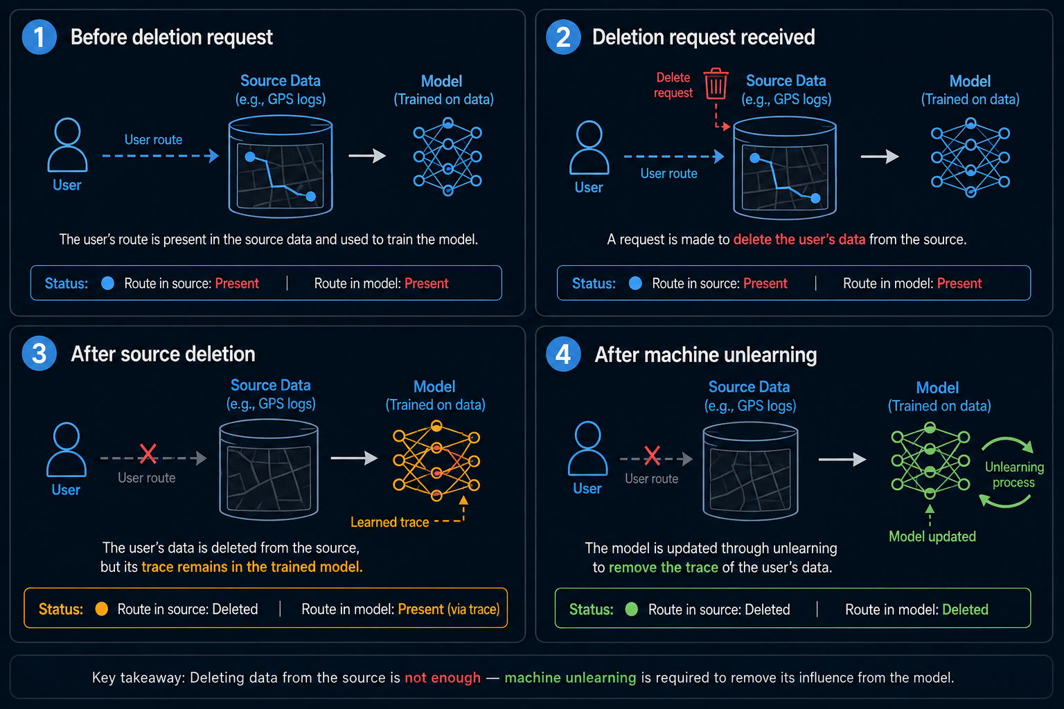
Source: AI- Generated
Deleting Data Is Not the Same as Unlearning
Removing a textbook from a student’s desk does not erase what the student has already learned from it. The same problem appears in machine learning. Deleting a file removes it from storage, but the trained model remains unchanged because its parameters were already influenced by that data.
The most reliable reference is to remove the selected records and train the model again using only the remaining data. This produces a model that was never exposed to the deleted information, but rebuilding a large model can require substantial time and computing resources. Machine unlearning aims to avoid that full rebuild. Exact methods try to reproduce the result expected from retraining, while approximate methods update the existing model more efficiently and accept some difference from the retrained reference.
Some systems can also be designed so that later removal is easier. SISA training divides the training data into isolated shards and trains separate component models. When one record must be removed, only the affected component needs to be retrained rather than the entire system. This can reduce computational cost, but geographic data creates an additional difficulty because nearby observations, repeated routes, and connected locations may not separate cleanly into independent groups.
For GeoAI, the challenge is therefore not only how to update the model. It is deciding what information belongs to the requested deletion and what geographic knowledge should remain.
Why Geographic Information Is Difficult to Forget
Geographic information is hard to unlearn because spatial observations are rarely independent. A single route, image tile, or sensor record usually carries information about a wider system around it.
Take mobility data. One person’s trajectory does not only describe that individual’s movement. It also contributes signals about road connectivity, travel times, popular junctions, and neighbourhood-level traffic rhythms. If a user asks the model to forget their commute, the system should remove that specific contribution without erasing the road network or the broader travel patterns supported by many other users.
The same problem appears in Earth observation. Landscapes are observed through overlapping image tiles, repeated satellite passes, and multiple sensors. Deleting one image does not mean the model has forgotten that place, because nearby tiles often share building patterns, vegetation structure, and land-use context. In other words, geographic learning is spatially connected: the influence of one sample often extends beyond its own border.
This makes geospatial unlearning more complex than deleting a customer profile from a database. A model may be asked to forget a coordinate, a user, a route, an image tile, or even an entire region. These are different tasks, and they require different levels of removal. TraceHiding addresses this problem in mobility data by identifying user-specific trajectory information while preserving movement patterns shared across many users. CallosumNet extends the problem to spatio-temporal graphs, where removing selected information must not break the wider spatial and temporal structure.
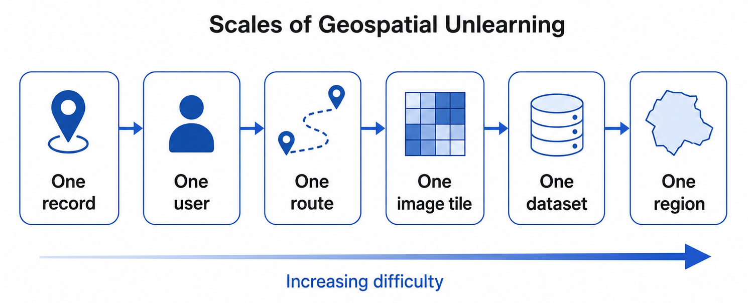
Scales of geospatial unlearning, from removing one record to an entire region, with difficulty increasing as spatial dependencies become broader.
What Might GeoAI Need to Forget?
GeoAI may need to forget information for several reasons. The most direct is privacy. Location histories can reveal homes, workplaces, travel routines, and visits to sensitive places. The GDPR provides a right to erasure in certain circumstances, although deleting stored records does not automatically explain how their influence should be removed from a trained model.
Unlearning may also become useful when training data are found to be unreliable. A dataset may contain incorrect coordinates, mislabeled imagery, duplicated observations, sensor errors, or manipulated map information. Removing the source files prevents future use, but it does not reverse their earlier contribution to the model. Data ownership can create a similar problem. If a provider withdraws a dataset or changes its licence, developers may need a way to reduce its influence without rebuilding the complete model.
Regulatory actions show why this distinction matters. In the Everalbum case, the US Federal Trade Commission required the deletion of face embeddings and facial-recognition models developed from certain user data. The WW International and Kurbo settlement similarly required the destruction of algorithms or other work products derived from unlawfully collected children’s data. These cases involved removing complete derived products rather than selectively unlearning individual samples, but they show that deleting raw data may not always be considered sufficient.
For GeoAI, future requests could involve one user, route, image, dataset, or sensitive location. Reliable removal at each of these scales remains an open technical problem.
How Do We Know the Model Really Forgot?
Successful unlearning has two goals. The selected information should no longer influence the model, while useful knowledge learned from the remaining data should stay intact. A model that forgets everything has removed the target information, but it is no longer useful.
The strongest reference is usually a model retrained from the beginning without the selected data. Researchers can compare the unlearned model with this clean reference to see whether their predictions and behaviour are similar. But matching accuracy alone is not enough. Machine-unlearning verification distinguishes between behavioural checks, which examine model outputs, and parametric checks, which inspect changes inside the model. Membership inference tests can also examine whether an auditor can still distinguish forgotten samples from data that were never used for training.
Unlearning can also create new privacy risks. Unlearning inversion shows that differences between the original and updated model parameters may contain information that can be used to reconstruct data intended to be forgotten. UnlearnShield was proposed to reduce this risk while preserving model accuracy and the effect of unlearning.
GeoAI adds another question: what happened around the removed information? If one user’s route is forgotten, predictions for neighbouring roads and communities should not change unnecessarily. If one satellite image is removed, the model should retain valid knowledge supported by overlapping images and nearby observations.
The ideal result removes the requested influence while leaving the rest of the geographic model as unchanged as possible. In GeoAI, proving that one record was forgotten may not be enough. We may also need to understand what changed around it.
Designing GeoAI That Can Forget Responsibly
Most AI systems are designed to retain useful information. Future GeoAI systems may also need to anticipate that some data could later require removal.
The first requirement is better data lineage. Developers need clear records of where training data came from, which geographic areas and time periods they cover, and what licences or permissions apply. Without this information, it may be difficult to identify which parts of a model were influenced by a user, dataset, sensor, or region.
The second requirement is architecture. Models could be designed so that selected data sources or components can be updated without rebuilding the entire system. However, geographic data cannot always be divided into independent regions because neighbouring locations often share roads, environmental patterns, and repeated observations. Any modular design would therefore need to preserve these spatial relationships.
Finally, unlearning must be independently tested. A model should not simply claim that information has been removed. Proof-of-ignorance auditing explores how successful and failed unlearning can be distinguished without always requiring complete retraining as a reference.
GeoAI may eventually need both persistent memory and controlled forgetting. Memory helps models understand how places change, while unlearning provides a way to remove information that should no longer influence them.
The challenge is not only to make machines learn more about the Earth. It is to help them remove what should no longer be remembered, preserve what still matters, and demonstrate the difference.
How do you like this article on machine unlearning? Read more and subscribe to our monthly newsletter!


