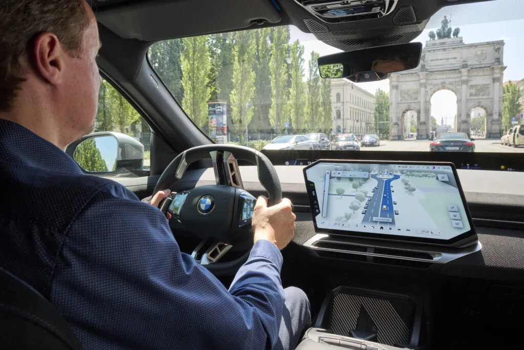

Mapbox CEO Peter Sirota explains how live vehicle detections, lane-level maps and a purpose-built rendering engine come together in BMW’s new navigation experience and why the implications extend beyond the dashboard.
A car can see the vehicle ahead. A map can show the road beneath it. Making the two agree, in the right lane, on the right level of an interchange, while everything is moving is where navigation gets interesting.
That was what I wanted to understand when I sat down with Mapbox CEO Peter Sirota to discuss BMW’s Magic Carpet navigation (Mapbox Launches 3D Live Navigation in Neue Klasse BMW Vehicles).
Before our call, I’d watched a video of Peter and BMW’s Stephan Durach driving around San Francisco. I couldn’t resist calling it “carpool karaoke meets maps.” But what held my attention was the display: a highlighted route stretching along the road ahead, with surrounding vehicles appearing inside the same navigation scene.
The visual effect is impressive. The more interesting question is what it takes to make that scene trustworthy.
The map and the vehicle’s sensors bring different versions of the world to the screen. Roads change. Positioning is imperfect. Sensors make mistakes. How do you bring those inputs together without making the driver do the work of figuring out where they disagree?
I’ve followed Mapbox since its early days and wrote about its move into in-car navigation back in 2016 (With Drive, Mapbox now has its sights on the in-car navigation market – Geoawesome). This conversation felt like a chance to see how far that ambition had come. Not just towards better-looking maps, but towards maps that help explain what a vehicle sees—and what it intends to do next.
More than a better-looking map
Think about the questions a driver needs to answer when approaching a complicated junction. Where should I go? Which lane am I in? What is around me? And, when driver assistance is active, what is the car about to do?
Peter described an experience designed to connect those questions. Surrounding vehicles and other detections appear directly in the navigation scene, while the Magic Carpet highlights the lane-level route ahead. When assisted-driving functions are active, the display can also show the vehicle’s intended trajectory.
For me, that is the important distinction. Making a map look more like the world is one thing. Using it to explain how the vehicle perceives that world—and what it intends to do next—is another.
This remains a conversation about navigation and driver assistance, not a claim that the display makes the vehicle autonomous. BMW also specifies that availability depends on the assistance package, location and road.
The useful question is whether bringing those elements together makes the vehicle’s behaviour easier to understand. Peter’s explanation made clear why doing so is harder than a polished demonstration might suggest.
Making two worlds line up
When I asked about combining lane-level information, buildings and live detections into one scene, I referenced Unity. Peter quickly corrected me: this experience uses Mapbox’s own rendering engine.
It was a useful correction. A navigation display has demands that go beyond drawing a convincing 3D environment. Peter pointed to map-specific tasks such as label placement, alongside the need to run efficiently on automotive hardware that already has plenty of other work to do.
The deeper challenge is getting the different sources of information to agree.
A vehicle detects objects relative to itself. A navigation map describes roads, lanes and buildings across a much wider area. Bringing those views together means placing detections consistently within the mapped geometry—and keeping them there as the vehicle moves.
Consider an overpass. A detected vehicle can appear close to your position while travelling on a completely different road level. Putting it at roughly the right horizontal coordinates is not enough. The road, lane and object need to belong to the same scene.
This was the part of the conversation that most interested me as a geospatial person. The interface makes the result look straightforward. Underneath it sits the work of reconciling geometry, positioning, perception and timing.
Peter said BMW became a Mapbox customer in 2019 and that this generation of the experience had been in development for at least a couple of years. Watching the demonstration, it is easy to overlook how much engineering goes into making those difficult parts disappear.
What should the driver actually see?
Getting information into the right place is only part of the problem. The next question is what deserves to be shown.
I asked Peter how the teams had decided what to include and what to leave out, given that the driver’s attention should remain on the road.
His answer began with an important acknowledgement: sensors make mistakes. Detected objects can change classification or orientation between observations. The system has to turn those unstable inputs into a presentation that remains steady and useful.
Peter argued that integrating detections into navigation makes those errors less forgiving. A strange-looking object in a separate perception display is one thing. An object placed incorrectly in the map someone is using to choose a lane is another.
That shifts the discussion away from how much detail a screen can accommodate. The challenge is not to show everything the system thinks it sees. It is to select information that helps the driver understand the situation, without giving uncertain detections more authority than they deserve.
David Sniderman added another consideration during the call: the experience spans the central display, the band at the base of the windshield and a 3D head-up display, with BMW deciding how to distribute information between them. A screenshot of the most detailed view therefore tells only part of the interface story (How BMW Maps combines navigation with driver assistance.).
I haven’t driven it yet, so I’m not going to turn a demonstration into a verdict on driver workload. We also did not discuss comparative measurements of distraction or missed turns. What the conversation revealed was substantial engineering around stability, selection and explanation—not simply visual richness.
The road feeds the map
The relationship also runs in the other direction. The map provides context for what the vehicle detects, while observations from vehicles can help update the map.
Peter described a shift from relying on location probes to using richer sensor inputs, including camera detections of signs, road markings and events. He said Mapbox uses AI systems to turn those inputs into map layers, with daily releases of its map.
“We literally release the world every single day,” he said.
It is a memorable way to describe the scale of the operation. But a daily release is not the same as every road being freshly observed every day. The distinction matters: release frequency and observation freshness answer different questions.
When I asked about changing road signs and conditions, Peter described camera detections of variable speed limits and incidents feeding into map information, traffic displays and arrival-time calculations. He also acknowledged the need to establish that an event is real rather than a perception mistake.
For me, this is where the mapping story becomes more interesting than the dashboard story.
A camera detecting a possible change produces an observation. Deciding that the map should change—and that other users should rely on the update—is a separate responsibility.
The value is not simply in collecting more signals. It is in deciding which signals are reliable, what they mean and when they should influence someone else’s journey.
What carries beyond BMW?
With such a tailored experience, I wanted to understand how much belonged to this particular BMW implementation and how much could be reused elsewhere.
Peter said the mapping and sensor-integration capabilities are part of Mapbox’s SDK, with support for different camera systems and implementations. He expected other manufacturers to follow BMW, although he did not name them or provide a rollout schedule.
That distinction matters commercially. An impressive implementation demonstrates what is possible. A reusable platform has to make it possible across different vehicles, sensors, computing resources, screens and design choices.
It also connects this launch to something that has long interested me about Mapbox: giving companies the tools to build their own location experience, rather than simply putting someone else’s map inside their product.
The BMW implementation shows how far that ambition now extends—from the appearance of the map to the relationship between navigation, vehicle perception and driver assistance.
From navigation to spatial AI
Our conversation eventually moved beyond cars. I asked how much of this work could carry over into robotics, delivery and other systems navigating the physical world.
Peter answered with a deceptively simple example: asking a language model for the nearest restaurant. A restaurant can be close in a straight line and much harder to reach if a river separates you from it.
Anyone working in geospatial will recognise the missing context. Nearest according to what? Walking distance? Driving time? An accessible route? The location of the next bridge?
The question sounds ordinary because people bring so much unstated knowledge to it. A useful answer needs more than a destination coordinate.
Peter sees Mapbox providing location infrastructure that helps AI applications work with those constraints. He extended the discussion to delivery robots, where following a pavement or crossing a road introduces questions that a point on a map cannot answer on its own.
I would not describe access to mapping and routing as proof that an AI system understands the physical world. It can make a system more useful without establishing that it can reason reliably about every situation.
But it does explain why the geospatial infrastructure matters.
The BMW experience offers a concrete example. It brings mapped information, live observations and intended movement together so a person can interpret them. In an AI workflow, another system may consume some of that information instead.
The common requirement is a dependable connection between the digital representation and the place where a decision has consequences. A confident answer—or a convincing visualization—is not a substitute for that connection.
The test that matters
I came away from the conversation excited, less because navigation had acquired another dimension than because of what that dimension was being used to connect.
The Magic Carpet is the visible part. Behind it are harder questions about where a vehicle is, what it has detected, how those detections relate to the map and which information is useful enough to put in front of a driver.
Towards the end of the call, I asked about trying the experience myself. Peter offered to help arrange a test drive. I’d like to take him up on that.
Because after all the discussion about rendering, sensors and spatial AI, there is a practical question left: when a junction gets complicated, does this help me understand what is happening without making me think harder about the screen?
That is what I want to find out from the driver’s seat.



#Business

Next article
CoStar’s $730 Million Vexcel Deal Is Really a Bet on Owning the Geospatial Data Supply Chain
CoStar Group’s planned $730 million cash acquisition of Vexcel Imaging looks, at first, like another expansion of its property-data portfolio. Strategically, however, it is more significant. CoStar is buying control over much of the aerial-imagery supply chain, from camera manufacturing and aircraft capture to processing, property analytics and external licensing.
That changes the question from “Why does a property-data company need aerial imagery?” to “What happens when a major property platform owns the infrastructure that produces it?”
The confirmed transaction
CoStar and Vexcel announced a definitive agreement on October 27. CoStar will pay $730 million in cash, with closing expected in early 2027, subject to regulatory approval. The agreement is also disclosed in CoStar’s SEC filing.
Vexcel says its aerial programme covers more than 45 countries, 320 metropolitan areas and 99.6% of the US population. It captures more than 60 million images annually, with resolutions typically between 7.5 and 15 centimetres. The company also manufactures UltraCam aerial sensors and operates the UltraMap processing ecosystem.
According to figures supplied by the companies, Vexcel generated more than $140 million in trailing revenue, grew by more than 30% and achieved an adjusted EBITDA margin of approximately 20%.
Those numbers imply a purchase price of roughly 5.2 times trailing revenue. If the stated margin is applied directly, the deal is valued at approximately 26 times adjusted EBITDA. These are indicative calculations based on management figures, not independently audited acquisition multiples.
CoStar is assembling a property data stack
The acquisition follows CoStar’s purchase of Matterport, which gave it a major position in indoor spatial capture and digital twins. CoStar’s filings put total Matterport consideration at approximately $1.93 billion.
Vexcel adds the exterior layer. CoStar could combine building interiors, high-resolution overhead imagery, listings, transaction records, ownership information and AI-derived property attributes.
The result would be more than a larger dataset. It would be a vertically integrated system for observing, modelling and commercialising the built environment.
CoStar says it intends to use Vexcel imagery and artificial intelligence to extract hundreds of attributes across approximately half a billion properties. That is a company ambition, not a demonstrated production outcome, but it explains why sensor ownership matters. Better temporal and spatial inputs can improve roof-condition estimates, building-change detection, catastrophe assessment and automated valuation models.
How the price compares
The closest industry precedent is Nearmap, another major aerial-imagery platform. Thoma Bravo completed its acquisition of Nearmap in 2022 at an equity value of approximately AUD 1.055 billion.
The transactions are not directly comparable because of currency, timing, geographic coverage and financial disclosure differences. Nevertheless, both show that frequently refreshed aerial imagery is being valued as recurring analytical infrastructure rather than simply a collection of photographs.
CoStar’s strategy also differs from imagery providers that sell into many industries without owning a dominant downstream property marketplace. Vexcel competes with companies and programmes including Nearmap, EagleView and Hexagon’s HxGN Content Program. Under CoStar, its commercial incentives may increasingly reflect property intelligence, insurance and real-estate workflows.
The customer-neutrality question
CoStar says Vexcel will retain its brand, management and external customer relationships. That reassurance matters because Vexcel imagery supports insurers, infrastructure operators, mapping companies, emergency-response teams and other analytics providers, some of which may overlap with CoStar’s current or future markets.
The concern is not that CoStar will immediately close the platform. A more plausible risk is gradual preferential treatment through pricing, licensing terms, update schedules, API access or access to derived attributes.
Independent geospatial analysis from Cercana Systems has similarly highlighted customer-access and vertical-ownership questions. Fresh, substantive discussion of the exact deal on LinkedIn and Reddit remains limited, so broader practitioner concerns about imagery pricing and vendor dependence should not be mistaken for direct evidence of post-acquisition changes.
CoStar also faces an execution challenge. It must integrate a sensor and aviation business while addressing sales-force and bookings concerns reported alongside its record third-quarter revenue, according to Real Estate News.
What to watch
The deal’s success should be measured through more than revenue growth. Important indicators will include whether Vexcel maintains neutral licensing, whether external customers receive comparable product access, and whether CoStar can produce valuable AI-derived property information without reducing transparency or customer choice.
CoStar is effectively betting that ownership of geospatial observation infrastructure will become a competitive advantage in property intelligence. That thesis is credible. The unanswered question is whether Vexcel can remain a broadly trusted imagery supplier while becoming a foundational component of CoStar’s platform.


