
CoStar’s $730 Million Vexcel Deal Is Really a Bet on Owning the Geospatial Data Supply Chain

CoStar Group’s planned $730 million cash acquisition of Vexcel Imaging looks, at first, like another expansion of its property-data portfolio. Strategically, however, it is more significant. CoStar is buying control over much of the aerial-imagery supply chain, from camera manufacturing and aircraft capture to processing, property analytics and external licensing.
That changes the question from “Why does a property-data company need aerial imagery?” to “What happens when a major property platform owns the infrastructure that produces it?”
The confirmed transaction
CoStar and Vexcel announced a definitive agreement on October 27. CoStar will pay $730 million in cash, with closing expected in early 2027, subject to regulatory approval. The agreement is also disclosed in CoStar’s SEC filing.
Vexcel says its aerial programme covers more than 45 countries, 320 metropolitan areas and 99.6% of the US population. It captures more than 60 million images annually, with resolutions typically between 7.5 and 15 centimetres. The company also manufactures UltraCam aerial sensors and operates the UltraMap processing ecosystem.
According to figures supplied by the companies, Vexcel generated more than $140 million in trailing revenue, grew by more than 30% and achieved an adjusted EBITDA margin of approximately 20%.
Those numbers imply a purchase price of roughly 5.2 times trailing revenue. If the stated margin is applied directly, the deal is valued at approximately 26 times adjusted EBITDA. These are indicative calculations based on management figures, not independently audited acquisition multiples.
CoStar is assembling a property data stack
The acquisition follows CoStar’s purchase of Matterport, which gave it a major position in indoor spatial capture and digital twins. CoStar’s filings put total Matterport consideration at approximately $1.93 billion.
Vexcel adds the exterior layer. CoStar could combine building interiors, high-resolution overhead imagery, listings, transaction records, ownership information and AI-derived property attributes.
The result would be more than a larger dataset. It would be a vertically integrated system for observing, modelling and commercialising the built environment.
CoStar says it intends to use Vexcel imagery and artificial intelligence to extract hundreds of attributes across approximately half a billion properties. That is a company ambition, not a demonstrated production outcome, but it explains why sensor ownership matters. Better temporal and spatial inputs can improve roof-condition estimates, building-change detection, catastrophe assessment and automated valuation models.
How the price compares
The closest industry precedent is Nearmap, another major aerial-imagery platform. Thoma Bravo completed its acquisition of Nearmap in 2022 at an equity value of approximately AUD 1.055 billion.
The transactions are not directly comparable because of currency, timing, geographic coverage and financial disclosure differences. Nevertheless, both show that frequently refreshed aerial imagery is being valued as recurring analytical infrastructure rather than simply a collection of photographs.
CoStar’s strategy also differs from imagery providers that sell into many industries without owning a dominant downstream property marketplace. Vexcel competes with companies and programmes including Nearmap, EagleView and Hexagon’s HxGN Content Program. Under CoStar, its commercial incentives may increasingly reflect property intelligence, insurance and real-estate workflows.
The customer-neutrality question
CoStar says Vexcel will retain its brand, management and external customer relationships. That reassurance matters because Vexcel imagery supports insurers, infrastructure operators, mapping companies, emergency-response teams and other analytics providers, some of which may overlap with CoStar’s current or future markets.
The concern is not that CoStar will immediately close the platform. A more plausible risk is gradual preferential treatment through pricing, licensing terms, update schedules, API access or access to derived attributes.
Independent geospatial analysis from Cercana Systems has similarly highlighted customer-access and vertical-ownership questions. Fresh, substantive discussion of the exact deal on LinkedIn and Reddit remains limited, so broader practitioner concerns about imagery pricing and vendor dependence should not be mistaken for direct evidence of post-acquisition changes.
CoStar also faces an execution challenge. It must integrate a sensor and aviation business while addressing sales-force and bookings concerns reported alongside its record third-quarter revenue, according to Real Estate News.
What to watch
The deal’s success should be measured through more than revenue growth. Important indicators will include whether Vexcel maintains neutral licensing, whether external customers receive comparable product access, and whether CoStar can produce valuable AI-derived property information without reducing transparency or customer choice.
CoStar is effectively betting that ownership of geospatial observation infrastructure will become a competitive advantage in property intelligence. That thesis is credible. The unanswered question is whether Vexcel can remain a broadly trusted imagery supplier while becoming a foundational component of CoStar’s platform.


#Business

Next article

Earth-observation systems produce vast historical archives, but the models creating those archives often behave as if every year were the first.
A crop-mapping model might process the latest Sentinel imagery, infer what is growing in each field and then hand the result to a separate consistency layer. That workflow can work, but it keeps temporal reasoning outside the model. A new study asks a deceptively simple question: what if the model could directly use its own earlier maps as another input?
The research, focused on the Copernicus High Resolution Layer Croplands production setting, offers a practical version of “memory” for GeoAI. The authors do not propose a general-purpose agent or a larger foundation model. Instead, they feed thirteen years of aligned historical class predictions and a Basic Vegetation Layer signal into the existing multi-source architecture.
The missing temporal context
Most land-cover systems already acknowledge that geography changes over time. The problem is where that logic lives. In many operational pipelines, the classifier sees only the current year while temporal rules are applied later. This separation makes the system harder to optimize end to end and prevents the current prediction from learning directly from previous output patterns.
The paper reframes those prior maps as a “free input modality”: free not because they cost nothing to produce, but because an operational programme has already created them. Instead of treating yesterday’s predictions as an inert archive, the model treats them as structured context.
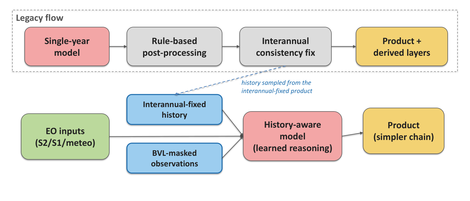
Turning old predictions into a new input
The added branch is deliberately lightweight. It consumes two aligned time series for each location: the product’s own class history and a vegetation mask. The model then combines those features with the baseline inputs used in production.
This matters because historical predictions encode more than class labels. They also capture the behaviour of the whole earlier production process: sensor availability, model decisions, local crop rotations and the way particular landscapes are represented. Used carefully, that record can help the new model distinguish genuine change from a one-year anomaly.
The approach is also operationally attractive. It does not require building a new continental reference database or acquiring a novel sensor. It reuses an asset the programme already owns.
Modest overall gains, larger gains where history matters
The headline improvement is not a dramatic leap in aggregate accuracy. That is important context. The value appears in more consistent predictions, class-level gains and fewer implausible year-to-year changes.
For a continental product, those changes can be strategically significant. Users often compare annual maps, measure transitions and detect trends. A small improvement in a single-year score may understate the benefit if the resulting time series contains fewer false flips.
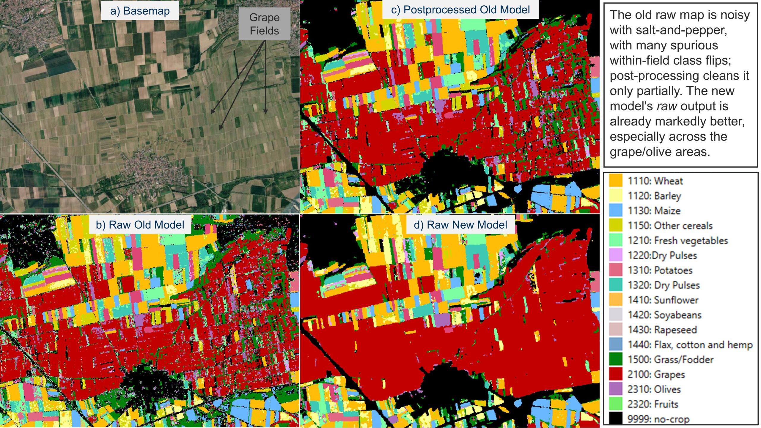
Why consistent masks matter
Temporal stability is not simply aesthetic. A noisy transition can be for crop rotation, land abandonment or a change in management. Those errors propagate into statistics, policy analysis and downstream machine-learning systems.
By making history available during inference, the model gains a prior about what is plausible at a location. The vegetation layer provides an additional constraint, helping it avoid classifications that conflict with the land’s broad physical state.
Not every problem needs a larger foundation model
The study lands at a moment when the geospatial AI conversation is dominated by foundation models and agentic workflows. Its lesson is more prosaic and possibly more useful: some operational improvements come from better system design rather than more parameters.
A mature mapping programme has accumulated valuable internal data. Turning that archive into a model input can be cheaper, more explainable and easier to deploy than replacing the entire stack.
The danger of inherited errors
History can also mislead. Previous maps contain their own systematic errors, and a model trained to trust them may repeat or reinforce those mistakes. The authors’ result should therefore be read as evidence for controlled temporal context, not as permission to treat past predictions as ground truth.
Future operational work will need to monitor error persistence, confidence calibration and performance in places where land use changes abruptly. New construction, extreme weather and changes in agricultural practice are exactly the cases where yesterday’s map may be least reliable.
GeoAI with memory
The broader implication extends beyond crop mapping. Any regularly updated geospatial product—buildings, roads, forests, impervious surfaces or settlement layers—could potentially use its own output history as context.
The shift is subtle: a mapping model stops being a sequence of isolated annual classifiers and starts behaving like a system with continuity. That is not full agentic reasoning, but it is a meaningful step toward GeoAI that understands not only where something is, but how its mapped state has evolved.
Research source: “Multi-Year Geospatial Reasoning using Interannually-Consistent Historical Predictions as a Free Input Modality”. The paper is a preprint and its reported findings have not yet been independently replicated.
How do you like this article? Read more and subscribe to our monthly newsletter!


