

CARTO co-founder Javier de la Torre will return as CEO on November 1, replacing Luis Sanz, who has led the company since 2019 and will remain on its board.
CARTO presents the transition as a planned handover aligned with what it calls its largest opportunity yet: Agentic GIS. According to the company, Sanz told the board earlier in 2026 that he wanted to step down once CARTO was ready for its next chapter.
That explanation may be entirely accurate. But founder returns rarely happen without strategic significance. De la Torre is taking control as CARTO must prove that its ambitious product vision can generate sustainable enterprise growth, defend the company against much larger competitors and satisfy the financial expectations attached to a venture-backed software business.
The company Sanz rebuilt
When Sanz became CEO, CARTO was still widely associated with web maps, visualization and CartoDB. Under his leadership, it repositioned itself around cloud-native spatial analytics.
The strategic bet was that organizations would increasingly store data in Snowflake, Google BigQuery, Databricks, Amazon Redshift and similar platforms. CARTO would run spatial analysis inside those environments rather than moving data into a separate GIS stack.
Investors supported that direction with a $61 million Series C round in 2021. CARTO subsequently expanded its enterprise platform, workflow tools, data marketplace and integrations with the major cloud-data providers.
De la Torre is not returning to reverse that strategy. He is returning to build the next commercial layer on top of it.
Agentic GIS is credible, but no longer uncontested
CARTO for Agents lets AI systems query governed customer data, execute spatial workflows and generate maps. Its components include a command-line interface, more than 20 agent skills and an MCP server that exposes approved workflows as agent tools.
The architecture addresses a genuine problem. General-purpose language models are poor at reliable spatial reasoning unless they receive the right tools, data and constraints. CARTO can provide deterministic spatial operations while keeping computation inside the customer’s existing warehouse and security environment.
But agentic GIS is rapidly becoming a competitive category, not a CARTO-exclusive market. Esri is adding assistants across ArcGIS. Mapbox exposes location services through MCP. Felt offers an MCP-based GIS interface. Google has opened experimental access to a Geospatial Reasoning Agent.
Snowflake, Databricks and other cloud-data companies could also absorb more spatial functionality into their own AI platforms. CARTO’s window of differentiation may therefore be shorter than its announcement suggests.
What about profitability?
There is no reliable public evidence that CARTO is currently unprofitable or experiencing a cash crisis. As a private company, it does not disclose consolidated revenue, operating profit, free cash flow, cash reserves or burn rate. Online revenue estimates vary so widely that they should not be treated as financial evidence.
Profitability pressure is nevertheless a reasonable hypothesis, provided it is clearly labelled as such.
CARTO raised its last publicly announced major equity round almost five years ago. That does not prove financial weakness. It could indicate capital discipline, sufficient recurring revenue or access to undisclosed financing. But it also means management must increasingly demonstrate that the 2021 investment created a scalable business rather than an expanding portfolio of technically impressive products.
CARTO’s current pricing model offers both metered consumption and committed enterprise tiers, including cloud-marketplace billing. That structure can reduce initial purchasing friction while securing larger annual commitments. Agentic workflows may increase query and compute consumption, creating revenue without requiring a proportional increase in licensed human users.
The risk is the opposite: if agents make individual analysts more productive, customers may need fewer seats. CARTO must capture part of the resulting value through consumption, enterprise governance and high-value production workloads.
Sovereignty offers a second route to revenue
De la Torre has also become a vocal advocate for European technological sovereignty. CARTO recently introduced Portolan and CARTO SDI, aimed at governments and data publishers that want interoperable spatial infrastructure under their own control.
This could open durable public-sector revenue, particularly as European institutions reconsider dependence on US-controlled clouds and proprietary platforms. Self-hosted, sovereign and air-gapped deployments can also command larger contracts.
However, government procurement is slow, implementation-heavy and politically exposed. CARTO will need to convert studies, specifications and institutional interest into funded deployments with repeatable economics.
The real meaning of the founder’s return
The optimistic interpretation is that de la Torre brings founder-level conviction at the moment when natural-language interfaces can finally democratize spatial analysis.
The more financially focused interpretation is that CARTO needs a sharper story, faster product decisions and stronger monetization after years of investment.
Both can be true.
The next evidence should not be another AI demonstration. It should be named production customers, agent usage at scale, independently measured reliability, public-sector contract wins and clearer commercial indicators. If those appear, the founder’s return may mark CARTO’s transition from cloud-native GIS challenger to a defining platform for agentic spatial work.
If they do not, Agentic GIS risks becoming a compelling new label in a market where every major platform is learning to speak the same language.


#Business
Next article

Electric utilities do not only have a shortage of wires, transformers and substations. They also have a visibility problem.
That is the opportunity behind Gridsight, an Australian grid-software company that has raised a $26 million Series B led by Insight Partners. Galvanize joined existing investors Airtree, Energy Transition Ventures and Aera VC. The company plans to use the funding to expand in the United States while continuing to grow in Australia.
Gridsight’s argument is simple: electricity networks are often planned around static, conservative assumptions even though available capacity changes by feeder, location, time of day and season. Better data cannot remove every physical constraint, but it can identify where existing infrastructure is being underused and where new investment is genuinely necessary.
For geospatial professionals, this is what makes the company interesting. Gridsight is effectively building a living electrical model from smart-meter data, GIS asset records, SCADA telemetry and information about distributed energy resources such as rooftop solar and batteries. It calls the result a Foundational Grid Model. In practical terms, it is an electrical digital twin designed to answer a spatial and temporal question: how much can this part of the network safely carry right now?
From a map of assets to a model of capacity
Traditional utility GIS tells an operator where poles, conductors, transformers and customers are located and how they are connected. That spatial topology remains essential, but it does not by itself reveal the condition of the network at a particular hour.
Gridsight adds smart-meter observations and electrical modelling to estimate local loads, voltage conditions, distributed generation and constraints. The company says its platform can automate connection screening, run physics-informed annual power-flow studies and calculate dynamic limits for imports or exports.
That distinction matters. A static map describes the grid. A capacity model tries to predict what the grid can safely do.
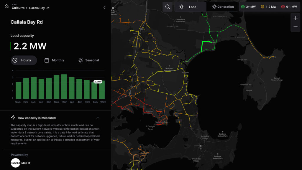
This follows the broader move from static representations toward living digital twins, where operational value depends on keeping topology, measurements and real-world conditions aligned. The International Energy Agency similarly argues that AI can improve grid forecasting, situational awareness and optimisation, but only when utilities turn meter and sensor data into operational decisions rather than simply collecting more information.
The Australian deployment provides the strongest evidence
The clearest public case comes from Endeavour Energy, which operates an electricity-distribution network in New South Wales.
Its Flexible Exports service replaces a fixed rooftop-solar export ceiling with a limit that can change according to local network conditions. Eligible single-phase customers can export as much as 10 kW when capacity is available, compared with the previous fixed 5 kW limit. The utility can reduce exports when required to protect reliability.
This is not merely a vendor presentation. An Endeavour Energy report filed with the Australian Energy Regulator says the Gridsight platform had moved into business-as-usual use, with tools for load estimation, photovoltaic-system detection, hosting capacity, power-quality monitoring and dynamic operating envelopes fully operational. At the time covered by the report, the flexible-exports trial involved more than 200 customers.
Gridsight subsequently reported that a measured cohort of 359 customers exported 171 MWh over 12 months that would otherwise have been curtailed. Endeavour projects that scaling the programme could unlock approximately 600 MW of additional rooftop-solar capacity and return more than $100 million to customers by 2035.
Those larger figures are forecasts, not independently measured outcomes. The distinction is important. The operational evidence shows that dynamic limits can release additional solar exports. It does not yet prove that the full 600 MW and $100 million will be realised.
Australia’s regulator also treats flexible export limits as one tool among several for managing hosting capacity. Its guidance stresses governance, transparency and consumer protections, including a meaningful fixed-limit alternative. From November 2026, Endeavour plans to make flexible exports the default for eligible new and upgraded solar systems, while allowing customers to opt for a lower fixed limit.
The US expansion is promising but earlier-stage
Gridsight names Xcel Energy and United Illuminating, an Avangrid subsidiary, as US customers. Public evidence is more detailed for United Illuminating.
Connecticut’s Innovative Energy Solutions programme lists a $1.1368 million project that will apply Gridsight’s platform to United Illuminating’s existing smart-meter and GIS data. The goal is to identify non-wires alternatives to conventional capital upgrades and improve hosting-capacity analysis across the utility’s service territory.
That is meaningful validation of the problem and the procurement route, but it remains a demonstration. Gridsight has not published measured US results showing shorter connection queues, avoided capital expenditure or additional capacity released. Its claims that some analyses can run 10,000 times faster and unlock 21% more capacity than assumption-based studies also lack a public independent benchmark.
Competition will be substantial. Established utility-software groups such as Siemens, GE Vernova and Schneider Electric are extending their platforms, while specialists including Camus Energy, Utilidata and Neara address overlapping parts of grid modelling, flexibility and asset intelligence. Gridsight’s advantage will depend less on the phrase “AI-powered” than on model accuracy, integration with legacy utility systems and whether regulators trust its outputs.
Software can reveal capacity, not manufacture it
The Series B arrives as data centres, electric vehicles and distributed generation compete for grid access. That creates a compelling market for software that can turn fragmented operational and geospatial data into faster decisions.
But the strongest editorial lesson is also the limitation. A digital twin can locate capacity hidden by conservative assumptions. It cannot fix an overloaded transformer, build a missing transmission line or eliminate the need for engineering review. Faster analysis may also expose institutional bottlenecks elsewhere in the connection process.
Gridsight now has funding, an operational Australian reference and initial US utility projects. The next proof point is whether it can reproduce the Australian outcome across different network models, regulations and data quality conditions. If it can, utility GIS may evolve from a record of where infrastructure is located into a continuously updated decision layer for where electrification can happen next.

