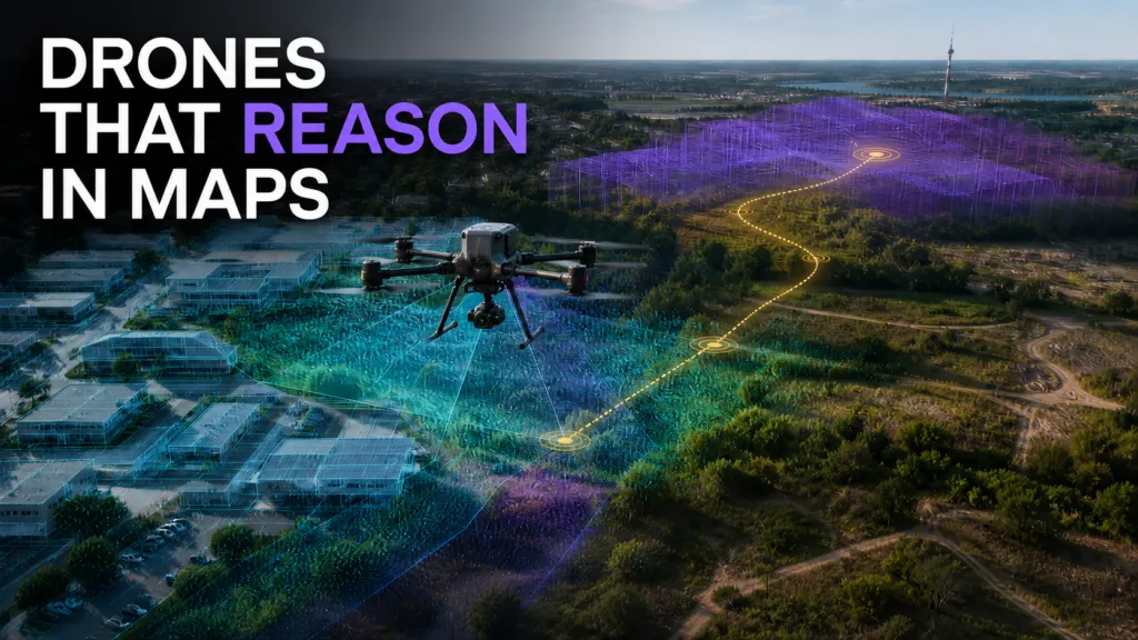

Vision-language navigation allows an autonomous system to interpret an instruction, relate it to camera observations and move toward a destination. For UAVs, the task is complicated by sparse viewpoints, three-dimensional movement and routes that extend beyond the immediately visible scene.
Many recent systems use language models or multimodal models to predict actions directly from instructions and imagery. A new framework called AirForesight takes a more explicitly spatial approach. It creates an internal representation of the current environment, reasons about a possible future spatial state and uses both to select the next 3D waypoint.
The work is notable because it treats mapping as part of an agent’s reasoning process rather than only as an input dataset or final output.
Giving the navigation agent a spatial state
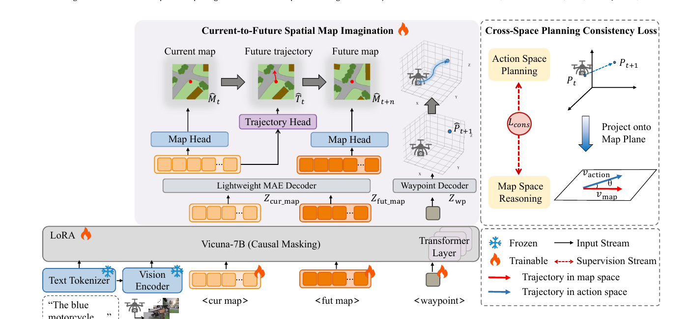
AirForesight begins with multiple visual observations around the UAV. These are organized into a structured current-map representation that encodes semantic and geometric relationships in the surrounding environment.
During training, the representation is supervised using both current-map reconstruction and future-trajectory prediction. A second stage propagates the current spatial knowledge into a representation of the anticipated future map. The two are then combined to predict the next waypoint.
The researchers also introduce a consistency objective that aligns the direction of the predicted map-space trajectory with the expert flight path. This is intended to prevent the spatial representation from becoming an auxiliary visualization with little influence on the action chosen by the agent.
Detailed map supervision is needed during training, but the operational model does not construct a complete dense map at every navigation step. That reduces the online processing burden compared with approaches that maintain a full explicit map during flight.
The framework was evaluated on OpenUAV and AerialVLN-S. The authors report improved navigation performance and stability relative to the selected baselines. The paper has been accepted by ACM Multimedia 2026. Earlier AerialVLN research established the broader task of instruction-guided UAV navigation in outdoor environments.
Why the mapping component matters
Direct action prediction can work well when instructions are short and relevant landmarks remain visible. Longer routes create a different requirement. The agent must preserve relationships between observations made at different moments and anticipate how movement will change the scene.
A structured spatial representation provides a common frame for those observations. It can connect a landmark described in the instruction with the agent’s current position and the direction of the intended route.
This has broader implications for agentic GeoAI. Spatial representations may function as working memory inside an autonomous system, supporting planning even when no conventional map is presented to the user. The map becomes an internal reasoning artifact.
Generalization remains the main challenge
AirForesight’s results come from benchmark environments rather than operational flight trials. The authors also identify several important limitations.
Its training maps use automatically generated labels. Errors in object grounding, segmentation, depth estimation or projection can enter the spatial supervision. The maps are useful learning signals, but they are not exact reconstructions.
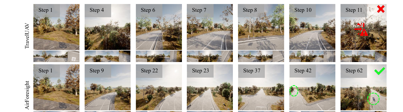
Part of the method estimates local trajectory direction using an approximation that is less reliable for sharp curves, sparse path masks or ambiguous geometry. Most importantly, performance still declines substantially on unseen maps and unfamiliar object categories.
The navigation policy also continues to use visual and language inputs alongside the learned spatial representations. The reported gains cannot be attributed to autonomous map reasoning alone.
These limitations define the next stage of evaluation: testing across genuinely unfamiliar geography, measuring sensitivity to incorrect spatial representations and exposing uncertainty when the internal map conflicts with current observations.
AirForesight does not yet show that a drone can reason reliably through an unknown real environment. It does offer evidence for a useful design principle: embodied AI benefits when spatial structure is represented explicitly rather than left for a general-purpose model to infer indirectly at every step.
How do you like this article? Read more and subscribe to our monthly newsletter!



#GeoAI

Next article

NavVis Raises $85M to Own the Spatial Data Layer for Physical AI
AI can write software, summarize contracts and generate convincing images. Asking it to navigate a factory full of moving equipment is a rather more expensive test.
NavVis believes the missing input is a continuously usable map of the physical world. The Munich-based reality-capture company has closed an $85 million Series D, led by The Jordan Company, with Yttrium, KOZO KEIKAKU and Cipio Partners also participating.
The round is large by recent geospatial hardware standards. It is also a bet on a business transition: from selling instruments that produce point clouds to controlling a spatial-data platform that AI systems, robots and industrial applications repeatedly consume.
The real asset is the update cycle
NavVis combines its mobile mapping systems with IVION, a cloud platform for managing and using captured environments. The company says more than 1,500 customers use its technology, including BMW, Siemens and ExxonMobil.
Its most revealing metric is not the customer count, however. NavVis says customers captured more than one billion square metres during 2025 and more than two billion cumulatively by late that year. Its current customer page now places the cumulative figure above 2.5 billion square metres.
Those are company-reported usage figures, not audited revenue. But they suggest a growing installed base and, more importantly, repeated capture. A building scanned once is a deliverable. A factory scanned every time production changes becomes a living operational dataset.
That distinction is central to the physical-AI pitch. Robots and autonomous equipment cannot depend on a beautiful digital twin that stopped matching reality six months ago. NavVis must therefore make recapture, registration and change management routine enough that customers maintain the model rather than archive it.
If that happens, IVION becomes more than a viewer. It can become the authoritative spatial record to which maintenance systems, BIM platforms, simulation environments and AI agents connect.
A market already consolidating
NavVis is not entering an empty category. At the capture layer, it competes with Leica Geosystems, FARO, Trimble, RIEGL and a growing range of lower-cost mobile and terrestrial scanners. Matterport remains powerful in accessible property digitization, while Cintoo competes at the platform layer by emphasizing hardware-neutral point-cloud management and open integration.
The market has also started consolidating. CoStar completed its acquisition of Matterport in 2025 in a deal valued at roughly $1.6 billion, bringing spatial capture into a much larger property-data platform. AMETEK acquired FARO the same year, folding laser scanning and digital-reality products into a diversified industrial technology group.
Against those transactions, an $85 million financing is not acquisition-scale capital. But it gives an independent NavVis room to expand while competitors gain access to larger corporate balance sheets and distribution networks.
The competitive split is increasingly clear. Some vendors own sensors. Others own design or asset-management workflows. Platform specialists promise to ingest scans from any device. NavVis is trying to span high-productivity capture and the cloud environment where the resulting data is organized and reused.
That integrated model offers quality control and a smoother workflow, but it also raises a customer question repeatedly voiced by practitioners: how easily can data move into other BIM, GIS and simulation environments without creating another proprietary silo?
Physical AI is an opportunity—and a demanding benchmark
NavVis has a credible route into the emerging industrial-AI stack through NVIDIA. In a current KION deployment, NavVis-derived spatial data and IVION act as the source environment for warehouse digital twins used with NVIDIA Omniverse and Isaac Sim. KION describes the workflow as a way to design, test and validate robotics in simulated facilities before deployment.
That is more meaningful than a generic “AI-ready” label. It shows where NavVis could sit in the value chain: upstream of simulation and robotics, supplying accurate environmental context.
But physical AI raises the performance bar. AI training needs consistent coordinates, semantic structure, timestamps, permissions and repeatable data quality across large estates. A photorealistic point cloud is not automatically a machine-readable operational model. NavVis must prove that it can convert growing capture volume into dependable, frequently updated data services.
It must also show the economics. The company has not disclosed valuation, revenue, software retention, hardware-versus-subscription mix or the allocation of the new funding. That makes it impossible to judge whether the round primarily funds growth, product development or the capital demands of an international hardware business.
The strategic logic is nevertheless strong. Previous waves of reality capture were sold around documentation, virtual access and scan-to-BIM productivity. The next wave is being sold as infrastructure for simulation, automation and robotics.
The scanner still opens the door. The larger prize is becoming the spatial memory every industrial machine consults before it acts.
Sources: NavVis funding announcement; NavVis capture metrics; Axios funding coverage; KION’s NavVis–NVIDIA deployment; Cintoo platform positioning.


