
NavVis Raises $85M to Own the Spatial Data Layer for Physical AI
AI can write software, summarize contracts and generate convincing images. Asking it to navigate a factory full of moving equipment is a rather more expensive test.
NavVis believes the missing input is a continuously usable map of the physical world. The Munich-based reality-capture company has closed an $85 million Series D, led by The Jordan Company, with Yttrium, KOZO KEIKAKU and Cipio Partners also participating.
The round is large by recent geospatial hardware standards. It is also a bet on a business transition: from selling instruments that produce point clouds to controlling a spatial-data platform that AI systems, robots and industrial applications repeatedly consume.
The real asset is the update cycle
NavVis combines its mobile mapping systems with IVION, a cloud platform for managing and using captured environments. The company says more than 1,500 customers use its technology, including BMW, Siemens and ExxonMobil.
Its most revealing metric is not the customer count, however. NavVis says customers captured more than one billion square metres during 2025 and more than two billion cumulatively by late that year. Its current customer page now places the cumulative figure above 2.5 billion square metres.
Those are company-reported usage figures, not audited revenue. But they suggest a growing installed base and, more importantly, repeated capture. A building scanned once is a deliverable. A factory scanned every time production changes becomes a living operational dataset.
That distinction is central to the physical-AI pitch. Robots and autonomous equipment cannot depend on a beautiful digital twin that stopped matching reality six months ago. NavVis must therefore make recapture, registration and change management routine enough that customers maintain the model rather than archive it.
If that happens, IVION becomes more than a viewer. It can become the authoritative spatial record to which maintenance systems, BIM platforms, simulation environments and AI agents connect.
A market already consolidating
NavVis is not entering an empty category. At the capture layer, it competes with Leica Geosystems, FARO, Trimble, RIEGL and a growing range of lower-cost mobile and terrestrial scanners. Matterport remains powerful in accessible property digitization, while Cintoo competes at the platform layer by emphasizing hardware-neutral point-cloud management and open integration.
The market has also started consolidating. CoStar completed its acquisition of Matterport in 2025 in a deal valued at roughly $1.6 billion, bringing spatial capture into a much larger property-data platform. AMETEK acquired FARO the same year, folding laser scanning and digital-reality products into a diversified industrial technology group.
Against those transactions, an $85 million financing is not acquisition-scale capital. But it gives an independent NavVis room to expand while competitors gain access to larger corporate balance sheets and distribution networks.
The competitive split is increasingly clear. Some vendors own sensors. Others own design or asset-management workflows. Platform specialists promise to ingest scans from any device. NavVis is trying to span high-productivity capture and the cloud environment where the resulting data is organized and reused.
That integrated model offers quality control and a smoother workflow, but it also raises a customer question repeatedly voiced by practitioners: how easily can data move into other BIM, GIS and simulation environments without creating another proprietary silo?
Physical AI is an opportunity—and a demanding benchmark
NavVis has a credible route into the emerging industrial-AI stack through NVIDIA. In a current KION deployment, NavVis-derived spatial data and IVION act as the source environment for warehouse digital twins used with NVIDIA Omniverse and Isaac Sim. KION describes the workflow as a way to design, test and validate robotics in simulated facilities before deployment.
That is more meaningful than a generic “AI-ready” label. It shows where NavVis could sit in the value chain: upstream of simulation and robotics, supplying accurate environmental context.
But physical AI raises the performance bar. AI training needs consistent coordinates, semantic structure, timestamps, permissions and repeatable data quality across large estates. A photorealistic point cloud is not automatically a machine-readable operational model. NavVis must prove that it can convert growing capture volume into dependable, frequently updated data services.
It must also show the economics. The company has not disclosed valuation, revenue, software retention, hardware-versus-subscription mix or the allocation of the new funding. That makes it impossible to judge whether the round primarily funds growth, product development or the capital demands of an international hardware business.
The strategic logic is nevertheless strong. Previous waves of reality capture were sold around documentation, virtual access and scan-to-BIM productivity. The next wave is being sold as infrastructure for simulation, automation and robotics.
The scanner still opens the door. The larger prize is becoming the spatial memory every industrial machine consults before it acts.
Sources: NavVis funding announcement; NavVis capture metrics; Axios funding coverage; KION’s NavVis–NVIDIA deployment; Cintoo platform positioning.



#Business
Next article
The geospatial industry has a workforce problem, but it is not the one suggested by the most alarmist version of the AI debate.
Artificial intelligence is not about to make geography irrelevant. Nor is adding a prompt-engineering module to every GIS course going to make the workforce “future-ready.” The real transition is more complicated: routine production work is becoming easier to automate at the same time that geospatial systems are becoming larger, more interconnected and harder to evaluate.
That combination changes the value of expertise. Knowing which buttons to press matters less when software can propose a workflow or write a script. Knowing whether the workflow is geographically defensible matters more.
This tension surfaced at the IEEE International Geoscience and Remote Sensing Symposium in Washington, D.C., where a 2026 panel titled “Geospatial Workforce 2030” brought together government, industry and early-career perspectives. In the panel preview, moderator Shawana Johnson argued that geospatial education is 10 to 15 years behind employer needs and said companies want AI capabilities without losing geodesy, photogrammetry and professional expertise.
That claim has generated a useful conversation. It should not, however, be treated as a settled labor-market statistic. The underlying workforce study is ongoing, and its full methodology and latest results had not been published publicly at the time of writing this article. The defensible conclusion is narrower: multiple independent indicators show that geospatial work is becoming more computational and interdisciplinary, while employers and educators are struggling to decide which skills belong at the center of the profession.
The labor market is asking for hybrids
The clearest public evidence comes not from predictions about AI but from actual job advertisements.
The U.S. Department of Labor’s O*NET database analyzed job postings associated with GIS technologists and technicians during 2025. ArcGIS remained the dominant named software, appearing in 75 percent of those postings. But Python appeared in 34 percent and SQL in 22 percent. JavaScript was present in 13 percent, while cloud services, PostgreSQL, Git and a long tail of development technologies also appeared.
Those figures do not show that every GIS analyst must become a machine-learning engineer. They show that the boundary between GIS production, data engineering and software development has become porous. Employers still want platform competence, but increasingly expect practitioners to automate, query databases, work with APIs and understand how spatial systems fit into wider technology stacks.
Official employment projections tell an equally nuanced story. The U.S. Bureau of Labor Statistics expects employment for cartographers and photogrammetrists to grow 6 percent from 2024 to 2034, faster than the average for all occupations, with around 1,000 openings annually. The much smaller occupational category of “geographers,” however, is projected to decline by 3 percent.
This is not evidence that geography is disappearing. It exposes a classification problem. People doing geographic work increasingly have titles such as data scientist, imagery analyst, location-intelligence specialist, geospatial developer, climate-risk analyst, product manager or solutions architect. The spatial component of work is spreading across industries even as the traditional “geographer” label captures a shrinking share of it.
The result is a market for hybrid professionals: people who can connect geographic reasoning to code, cloud infrastructure, Earth observation, statistics and a specific operational domain.
What I look for when hiring geospatial professionals
That hybrid profile also reflects what I look for when hiring. In my work with PwC’s Drone Powered Solutions and Geospatial Hub, our teams operate across drone and satellite analytics, photogrammetry, location intelligence, GIS architecture, custom software and AI-enabled analysis.
I expect candidates to have strong geospatial technical skills demonstrated through real project experience. They should understand spatial data, analytical methods, data quality, uncertainty and how geospatial outputs support operational or business decisions. Knowing the software is not enough; they must understand the reasoning behind the analysis.
At the same time, I increasingly expect practical AI skills. Used well, AI can accelerate coding, data preparation, research, documentation, prototyping and repetitive analytical work. That can materially improve productivity—but only when the person using it can evaluate the inputs, challenge the assumptions and recognize when the result is geographically wrong.
A technically weak practitioner equipped with AI may simply produce incorrect answers faster. A strong geospatial professional who ignores AI, however, leaves substantial productivity gains unused. The strongest candidates combine both: deep spatial competence and the ability to use AI as a force multiplier.
AI changes the workflow before it changes the profession
The near-term effect of AI is easier to see at the task level than at the job-title level.
Code assistants can already accelerate Python and SQL development. GeoAI models can extract buildings, roads or land-cover classes from imagery. Natural-language interfaces can help users find datasets, construct queries and assemble geoprocessing chains. Foundation models are beginning to support similarity searches, change analysis and prompt-based interpretation of remote-sensing scenes.
These capabilities put pressure on work that is repetitive, standardized and easy to check. Manual digitization, boilerplate scripting, first-pass classification, metadata drafting and routine map production are obvious candidates. An organization may need fewer hours to produce the same output.
But geospatial work rarely ends with production. Someone still has to decide whether the source imagery is current enough, whether two datasets use compatible definitions, whether the scale supports the claimed conclusion, whether positional error changes the decision, and whether a model trained in one landscape can be trusted in another.
This is why “AI will replace GIS” is the wrong frame. GIS is not one task. It is a system for representing place, integrating evidence and supporting decisions. AI can automate components of that system, sometimes dramatically, without assuming responsibility for the system as a whole.
The important workforce question is therefore not whether a professional can use AI. It is whether that person can supervise an increasingly automated spatial process.
The dangerous gap is validation
Generative tools are particularly good at producing plausible outputs. In a geospatial context, plausibility can be dangerous.
A polished map can conceal an inappropriate projection. A convincing land-cover layer can encode a class definition that does not match the policy question. A natural-language assistant can generate syntactically correct code that applies the wrong spatial predicate. A model can achieve strong aggregate accuracy while failing systematically in the locations where its output matters most.
That makes several traditional competencies more valuable, not less:
- understanding scale, resolution, uncertainty and spatial dependence;
- tracing how data was acquired and transformed;
- designing validation samples and recognizing geographic bias;
- distinguishing correlation from a process that makes sense in place;
- documenting reproducible workflows and preserving provenance;
- communicating limitations to decision-makers.
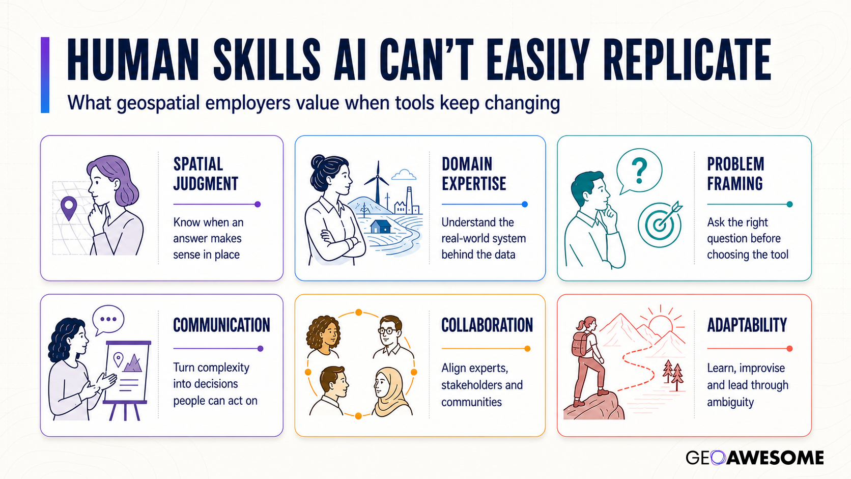
The human edge in GeoAI is not simply technical control. Employers still value spatial judgment, domain expertise, problem framing, communication, collaboration and adaptability when tools keep changing.
Mohamed Ahmed, a GeoAI practitioner and educator, summarized this concern in a LinkedIn discussion about teaching GIS in the AI era: an output that looks right is not necessarily right. He argued that students need stronger spatial foundations because they must ask where data was collected, at what scale, under which assumptions and whether the result makes sense in the specific place being analyzed.
This is practitioner opinion, not experimental evidence. Yet it accurately identifies the professional responsibility that automation does not remove. The easier it becomes to generate an analysis, the more important it becomes to know how to challenge it.
Are universities actually behind?
The answer depends on which part of the curriculum one examines.
A 2026 study in Transactions in GIS analyzed 532 GIS-related courses from 57 professional master’s programs at 44 U.S. universities. It found strong system-wide emphasis on data capture, analytics and modeling. Remote sensing and spatial statistics were prominent, and programming and visualization had substantial representation.
The gaps were revealing. Computing platforms—including cloud services, distributed processing, enterprise deployment and scalable web GIS—appeared less explicitly in course descriptions. Societal and organizational subjects were also less visible. These include law, ethics, governance and the institutional context in which geospatial decisions are made.
The authors caution that course descriptions are imperfect proxies. Programming or cloud skills may be embedded in project courses, and ethics may be taught without appearing in a course title. The GIS&T Body of Knowledge used for comparison can itself lag fast-moving topics such as GeoAI.
Even with those limitations, the research suggests that universities are not simply teaching obsolete desktop cartography. Many programs cover contemporary analytical skills. The deeper problem is unevenness: modern production infrastructure and critical governance competencies may be implicit, optional or dependent on individual instructors.
That is difficult to solve with a single new “AI for GIS” course. A student might learn to fine-tune a model and still leave without knowing how to deploy a reproducible pipeline, estimate its operating cost, audit its geographic error or explain its limitations to a planning department.
A more useful model is emerging
Several recent initiatives point toward a better response.
The Canadian Space Agency and Carleton University are working with more than a dozen industry, government, academic and nonprofit partners to redesign Earth-observation education. Their 2026 ISPRS paper says the gap between graduate skills and market needs is widening as cloud computing, GeoAI and foundation models change remote sensing. The response includes revised university courses, shorter modules, mini-courses and microcredentials informed by both hard- and soft-skill needs.
The significance is not the addition of more technology content alone. The project treats curriculum as something that must be updated continuously with employers and practitioners, rather than revised once every several years.
Research involving YouthMappers participants reaches a complementary conclusion. Students across a global open-mapping network believed project-based, collaborative and humanitarian work strengthened their employability. The study found regional differences in access to training and tools, and recommended partnerships that place experiential, globally connected learning alongside formal courses and internships.
This matters because real geospatial competence is difficult to acquire through isolated exercises. A student learns more about data quality by reconciling inconsistent field observations than by following a perfect tutorial. They learn more about communication by defending an analytical choice to a community partner than by exporting a technically correct map.
The UN-GGIM position paper on the future geospatial information ecosystem pushes the same logic to policy level. It recommends embedding AI, data ethics, semantic integration and algorithmic transparency in geospatial education, while shifting from one-off training toward continuous learning supported by open resources, mentoring and microcredentials. Crucially, it calls for a move from technical training to “knowledge fluency”: teaching people to think spatially across domains and technologies rather than merely operate particular tools.
The entry-level paradox
This may be the most important workforce issue of the AI transition.
Many junior tasks are tedious precisely because they expose people to the imperfections of real data. Digitizing teaches that boundaries are ambiguous. Cleaning addresses reveals that administrative definitions do not align neatly. Comparing imagery teaches the effects of seasonality, shadows and sensor differences. Quality assurance shows how minor upstream decisions propagate into finished products.
Automating this work can improve productivity, but removing it without designing a replacement learning pathway creates a hollow pipeline. Organizations could end up demanding senior judgment from employees who were never given the opportunity to develop it.
The answer is not to preserve repetitive work for its own sake. It is to redesign junior roles around supervised automation, evaluation and progressively more complex decisions. An entry-level analyst should learn how to inspect model output, build tests, document provenance, investigate failure cases and explain uncertainty—not merely accept whatever the system generates.
Employers will also need to distinguish productivity from competence. Someone who can generate ten workflows in a day is not necessarily more valuable than someone who prevents one consequential spatial error.
What a future-ready geospatial curriculum should contain
A credible curriculum for the next decade needs five interlocking layers.
Spatial foundations: coordinate systems, scale, topology, spatial statistics, geodesy, cartography, remote-sensing physics and uncertainty.
Computational practice: Python, SQL, APIs, version control, testing, cloud infrastructure, spatial databases and reproducible data pipelines.
AI literacy: model selection, training data, evaluation, embeddings, foundation models, prompt-based interfaces and automation—but also geographic transferability, hallucination, bias, provenance and cost.
Domain fluency: substantial work in an application area such as climate, mobility, utilities, public health, agriculture, defense or urban planning.
Professional judgment: ethics, law, security, communication, project design, stakeholder engagement and the ability to challenge an automated result.
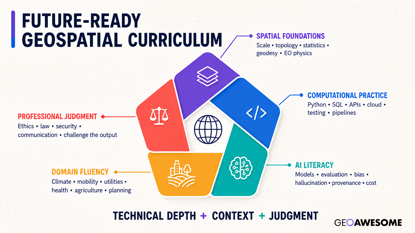
A future curriculum should connect technical depth with domain context and professional judgment.
Not every professional must be expert in every layer. Teams need complementary specialists. But everyone working with automated spatial analysis should understand how the layers interact and where responsibility sits.
AI is raising the bar, not removing it
The strongest interpretation of the geospatial skills gap is not that established professionals have become obsolete or that universities have ignored technology for 15 years. It is that the profession’s center of gravity is shifting.
Production competence remains necessary, but it is no longer sufficient. The differentiating skills are moving upward: from executing tools to designing systems, from creating outputs to validating them, and from delivering maps to shaping decisions.
AI can make geospatial analysis more accessible and more productive. It can also make weak analysis faster, cheaper and more convincing. The workforce that succeeds will therefore not be the one that adopts the most AI. It will be the one that combines automation with geographic judgment—and builds education, junior roles and professional standards capable of sustaining both.


