

Open Cosmos has raised €300 million to expand satellite manufacturing and build out its Earth observation, connectivity and data-intelligence businesses. It is one of the largest recent funding rounds for a European space company, but its real significance is not the size of the cheque. The company is trying to prove that sovereign space infrastructure can be delivered as a repeatable commercial platform rather than as a series of slow, bespoke government programmes.
The round was led by Lightrock, with participation from European investors, two pension funds and the UK’s National Security Strategic Investment Fund. Open Cosmos says the money will expand four products: OpenOrbit for satellite missions, OpenConstellation for shared capacity, ConnectedCosmos for broadband and IoT, and DataCosmos for operational intelligence.
This is a much larger bet than manufacturing more small satellites.
From satellite projects to infrastructure
Open Cosmos says it can manufacture one satellite per day across facilities in the UK, Spain, Portugal and Greece. That describes theoretical capacity, not current output. The company has not disclosed how many spacecraft it expects to deliver annually after the expansion.
There is evidence of a growing business underneath the announcement. The company reports more than $370 million in signed contracts over three and a half years. Its UK group accounts show turnover rising from £6.5 million in 2023 to £45.9 million in 2025, with a £5.7 million operating profit. That supports the growth claim, although contracts are not recognized revenue.
The round therefore finances a transition. Open Cosmos has shown that it can build missions for institutions and regional governments. It must now show that it can industrialize production while operating its own shared infrastructure and selling higher-margin intelligence and connectivity services on top.
Its most distinctive idea is OpenConstellation. Instead of requiring every country or region to finance a standalone fleet, participating customers contribute satellites and share data from the wider network. Portugal’s planned spacecraft, the UK’s Atlantic Constellation pathfinder and regional missions such as the Balearic Islands’ Posidònia satellite illustrate the model.
For smaller countries, the proposition offers tasking influence and locally relevant data without paying for an entire constellation. For Open Cosmos, sharing assets could create recurring revenue and a larger multisensor network.
Sovereignty is creating a market
The financing arrives as European governments redefine space systems as critical infrastructure. Russia’s invasion of Ukraine exposed the military and political value of commercial satellite imagery and connectivity, but also the risk of depending on infrastructure controlled outside Europe.
That has produced a spectrum of sovereign procurement. Governments can buy access to commercial imagery, reserve capacity, acquire dedicated satellites or fund national constellations. Open Cosmos is positioning itself across all four layers, from spacecraft manufacturing to the final intelligence product.
The model sits between traditional prime contractors and pure data companies. Airbus, Thales Alenia Space and OHB remain formidable. Aerospacelab is scaling mass production through IRIS². Planet offers governments dedicated optical constellations. ICEYE reports seven sovereign radar-system customers and raised €450 million in 2026. EnduroSat raised $205 million days after Open Cosmos to expand standardized fleets.
Open Cosmos is less specialized than ICEYE and much smaller than the primes. Its advantage is flexibility: it can combine different payloads, distribute manufacturing across several European countries and offer shared ownership economics. Its risk is that this breadth creates too many businesses to scale simultaneously.
The hard part is the use case
Open Cosmos describes a compelling future in which a satellite detects a forest temperature anomaly, onboard AI classifies a likely fire, inter-satellite links relay the alert, and connectivity services deliver it directly to responders. Similar architectures could support maritime surveillance, flood response, infrastructure monitoring, agriculture and border security.
But these markets do not struggle because imagery is unavailable. They struggle with cloud cover, revisit gaps, false positives, integration and delays between receiving an alert and acting. A 30-minute delivery claim matters only if the satellite can observe the location, classify the event reliably and reach an operational user.
Connectivity brings a different set of difficulties. Open Cosmos used Liechtenstein’s Ka-band filings for ConnectedCosmos and launched initial satellites quickly, but it subsequently sought more time to meet an International Telecommunication Union deployment milestone after India’s PSLV launcher was grounded. The episode shows that sovereignty does not remove dependence on launch providers, spectrum rules, ground infrastructure or component supply chains.
Open Cosmos must also reconcile shared infrastructure with sovereign control. Governments will ask where data is processed, who can retask assets during a crisis, which components come from outside Europe and what happens when participating countries have conflicting priorities. “Sovereign” cannot simply mean that the supplier is European. It requires enforceable control over operations, encryption, access, maintenance and replacement capacity.
What €300 million must prove
The funding gives Open Cosmos enough capital to become a major European satellite company. It does not guarantee that its four-layer platform will become a coherent business.
The indicators to watch are operational rather than promotional: satellites delivered per year, independently measured mission reliability, revenue recognized from the reported contract book, recurring data and connectivity revenue, and named customers using OpenConstellation intelligence in live workflows. The company also needs to demonstrate that its 30-minute delivery target works across representative use cases, not only selected demonstrations.
If Open Cosmos succeeds, Europe gains something it has often lacked: a commercially disciplined company capable of connecting regional manufacturing, shared satellite infrastructure and operational geospatial services. If it struggles, the likely reason will not be an inability to build satellites. It will be the much harder task of turning sovereign ambitions and orbital data into dependable services that governments use every day.



#Business

Next article
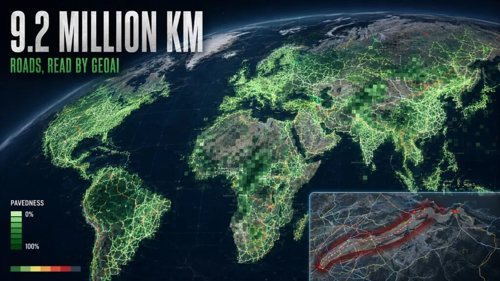
Most global road maps can tell us where a road is. Far fewer can tell us whether it is paved, how wide it is, or whether it might keep a relief convoy moving after a flood.
A new peer-reviewed study in Nature Communications shows how satellite imagery and deep learning can begin to close that gap. Researchers from Heidelberg University and HeiGIT mapped road surface type and estimated width across 9.2 million kilometres of the world’s critical arterial roads.
The result is not simply a more complete road inventory. It is an attempt to turn imagery into infrastructure intelligence.
From road lines to road condition
The team started with OpenStreetMap geometries for motorways, trunk, primary and secondary roads. It then analysed 3 to 4 metre PlanetScope imagery from 2020 and 2024 using a fine-tuned Mask2Former segmentation model.
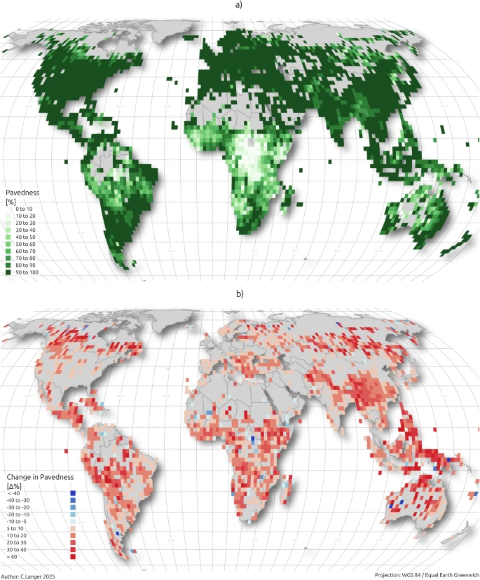
The resulting dataset covers 95.5% of the selected 9.2 million-kilometre network. Nearly half of those roads previously lacked a surface classification. The researchers also found that OpenStreetMap tags for unpaved roads achieved only 26% average global accuracy in their human-validated comparison, often because attributes had not kept pace with development on the ground.
This is an important distinction. OpenStreetMap remains the indispensable geometry layer, while Earth observation provides a way to update physical attributes at scale. The two are complementary rather than competing systems.
A new layer for infrastructure decisions
Road surface data revealed a pronounced urban-rural divide. Urban arterial networks were more than 93% paved across all regions, while rural pavedness in Sub-Saharan Africa averaged 61.4%, compared with 97.2% in Europe and Central Asia.
The researchers also found that changes in pavedness between 2020 and 2024 correlated with human development after accounting for each country’s starting point. That does not prove that paving causes development, but it suggests that frequently updated road-condition maps could complement slower official statistics and coarse proxies such as night-time lights.
The most operational part of the work is a Humanitarian Passability Score. By combining estimated width and surface type, the framework distinguishes high-capacity supply corridors from narrow or weather-sensitive chokepoints.
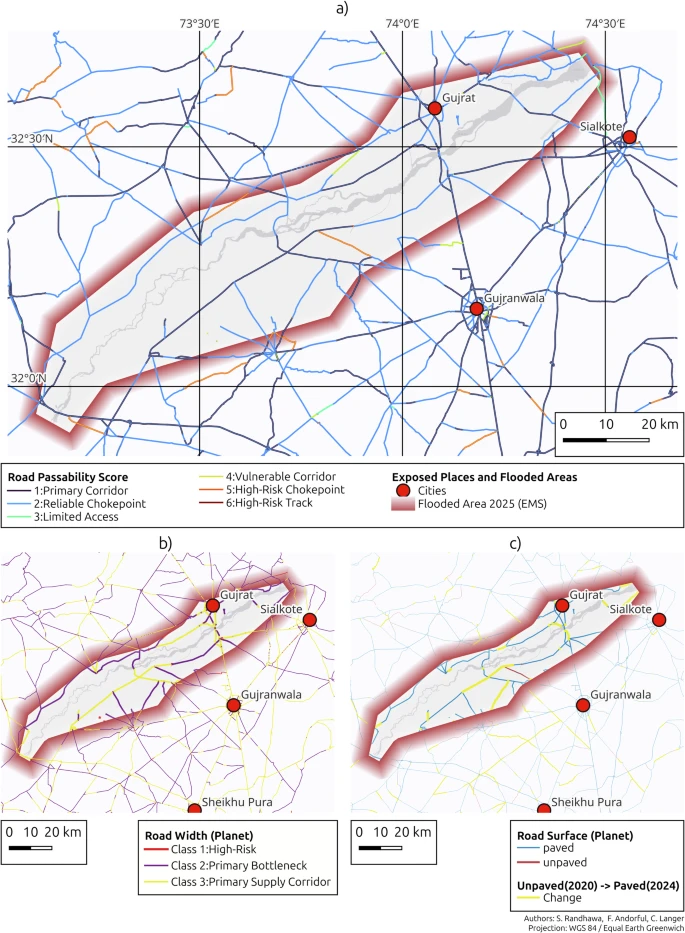
For humanitarian teams, development banks and governments, that is potentially more useful than another global road centreline dataset. It begins to answer whether a mapped route is likely to support the vehicles and loads required during an emergency.
The resolution ceiling still matters
The authors are careful about the limitations. PlanetScope imagery cannot resolve individual lanes, so road width is a first-order estimate. Clouds, shadows, vegetation, moisture and seasonal changes can also create apparent deterioration or improvement where none occurred.
The passability score is not a live declaration that a road is open. It is a structural indicator that would still need recent weather observations, flood data and field verification before operational use.
There is also a licensing distinction. The derived vector dataset is available through the Humanitarian Data Exchange under a non-commercial Creative Commons licence, while the underlying Planet imagery cannot be redistributed.
Still, the strategic direction is clear. GeoAI is moving beyond extracting buildings and road geometry. The next valuable products will describe what infrastructure is made of, how it changes and what it can actually support.


