

Synspective’s Munich Hub Is a Commercial Bet on Europe’s SAR Demand
Europe has plenty of radar coverage. What it does not have is a shortage of companies hoping to sell the next layer of radar-derived intelligence.
Japan’s Synspective is establishing Synspective Europe GmbH in Munich as its commercial base for Europe, the Middle East and Africa. The subsidiary will sell synthetic-aperture radar data and analytical services, support customers and pursue partnerships with government, research and industrial organizations.
The company announced the plan in February 2026, targeting establishment during the first half of the year. Recent industry coverage describes the hub as opening, so this is an execution milestone rather than a newly disclosed strategy.
That execution matters because Europe is one of the world’s most attractive—and difficult—commercial SAR markets.
Local presence is part of the product
A German legal entity gives Synspective direct access to EU procurement, consortium formation and regional funding programs. It also shortens the distance between the satellite operator and customers that care about data governance, security reviews, technical support and long contracting cycles.
Synspective explicitly lists those administrative advantages among the subsidiary’s objectives. The company appointed Iain MacInnes, who previously held senior EMEA roles at Maxar and DigitalGlobe, to lead the business. It is also recruiting sales and technical staff in Munich.
That tells us what the office is designed to do: build a regional pipeline, not operate satellites from Bavaria.
In Earth observation, proximity can be commercially decisive. Infrastructure owners need integration and repeat monitoring rather than isolated scenes. Defence and intelligence buyers prefer suppliers that can participate in local procurement frameworks. European-funded programs may require eligible entities and regional partners.
The satellite may be global, but the route to revenue remains local.
Synspective enters from behind the fleet leader
Synspective says it currently operates five small SAR satellites and aims to exceed 30 by 2030. That is meaningful capacity, but it is not market leadership.
The company’s own August 2025 investor material compared four Synspective satellites with 35 for ICEYE, seven for Umbra, six for Capella and four for Japan’s QPS Research Institute. Fleet counts change quickly, but the benchmark illustrates the competitive gap Synspective must overcome.
ICEYE is the most immediate European reference point. It has a larger fleet, established government relationships and an increasingly integrated model spanning data, sovereign satellite systems and defence partnerships. Free Copernicus Sentinel-1 data sets another benchmark at the broad-coverage end of the market. American operators such as Umbra and Capella compete for high-resolution and tasking-intensive use cases, while European incumbents including e-GEOS bring distribution, processing and institutional relationships.
Synspective has begun addressing that last point through a strategic partnership with e-GEOS announced in May 2026. The logic is sensible: combine an expanding Japanese constellation with a European company already embedded in regional geospatial-intelligence markets.
The question is how Synspective differentiates. More satellites improve revisit, but fleet size alone does not create pricing power. Customers increasingly compare delivery latency, tasking reliability, licensing terms, analytical products and the ability to integrate SAR with other sources.
A government anchor changes the risk profile
Synspective is not approaching Europe as an unproven startup. The European Space Policy Institute reported that the company secured a Japanese Ministry of Defense agreement valued at ¥105.6 billion—approximately €570 million at the cited exchange rate—for SAR imagery and related activities beginning in 2026.
That contract provides something commercial EO companies often struggle to obtain: a large government demand anchor capable of supporting constellation expansion.
It does not guarantee success in Europe. Procurement rules, security priorities and domestic industrial policies differ. European buyers may favor sovereign capacity or local manufacturing, particularly as SAR becomes more closely associated with defence and resilience.
This is where Munich becomes strategically useful. Synspective can join consortia, develop local partnerships and potentially move from selling scenes toward contracted monitoring services. Public discussion around the launch has been enthusiastic about Munich’s growing EO cluster and potential collaboration in maritime awareness. The harder commercial questions—regional staffing, investment, customer commitments and revenue targets—remain unanswered.
The disclosed €25,000 share capital is simply the statutory minimum for a German GmbH and should not be mistaken for the scale of the expansion. Synspective has not said how much it will invest in the subsidiary or announced an anchor EMEA contract alongside the opening.
The market test
The Munich hub will succeed if it lowers the friction between orbit and operational decisions. That means helping a port monitor activity, an insurer assess change, an infrastructure owner track deformation or a government procure persistent surveillance without building the entire processing chain itself.
Synspective’s competitive challenge is therefore not “Can it produce SAR imagery?” It is whether a smaller operator can use analytics, local relationships and targeted partnerships to win customers from larger or more deeply embedded rivals.
Europe is a logical place to test that proposition. It is also an unforgiving one.
Sources: Synspective subsidiary announcement; company filing; GeoConnexion coverage; ESPI February 2026 industry review; Synspective August 2025 financial presentation.
How do you like this article? Read more and subscribe to our monthly newsletter!



#Business
Next article

Traditional land-cover models are fussy creatures. Train one to recognize buildings, roads and trees, then ask it to find swimming pools or solar panels, and it may stare back blankly.
GeoSeg-OV wants to make that problem disappear.
The new research framework explores “open-vocabulary” remote-sensing segmentation: identifying every pixel belonging to a category described in ordinary language, including categories the model did not encounter during training.
In theory, this moves GeoAI closer to a much more flexible workflow. Instead of building and labeling a new training dataset whenever the mapping question changes, an analyst could supply a new vocabulary and let the model search for it.
The difficulty is that Earth rarely looks consistent from above. A building photographed by a drone at 5-centimeter resolution looks very different from one captured by a satellite at 60 centimeters. Geography, climate, sensors, viewing angles and image resolution all create what the researchers call a “geospatial gap.”
GeoSeg-OV’s trick is to separate meaning from shape.
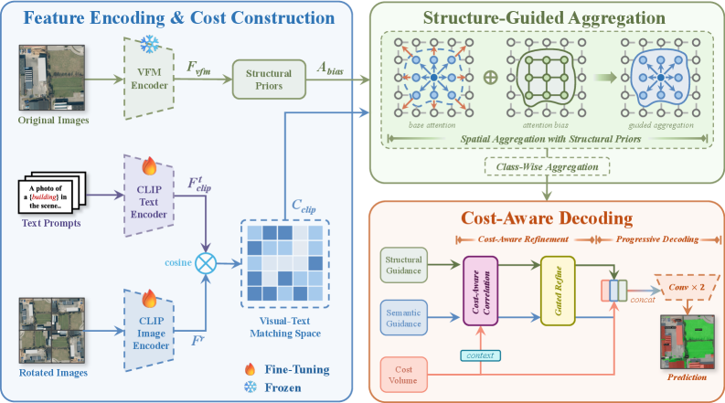
CLIP, a vision-language model, handles the semantic question: does this part of the image resemble the requested category? A second, frozen vision foundation model supplies structural guidance—boundaries, spatial relationships and object shapes—without interfering with that visual-language matching process. The system also examines rotated versions of the imagery because, unlike photographs of cats, satellite images do not come with a universally correct “up.”
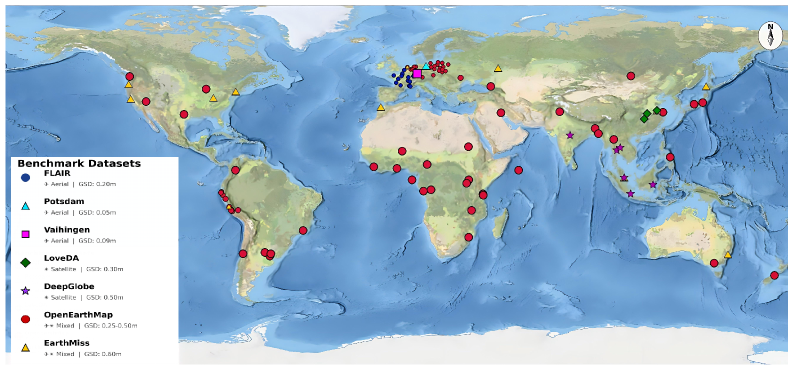
The researchers tested the approach using a new High-Resolution Land Cover benchmark covering seven datasets, more than 90 cities, six continents and imagery with ground resolutions from 5 to 60 centimeters.
According to the GeoSeg-OV preprint, the method improved average mean intersection-over-union by 2.5 and 2.7 percentage points over the strongest previous trainable approaches under two training configurations. It ranked first on five of six external datasets when trained on FLAIR and all six when trained on OpenEarthMap.
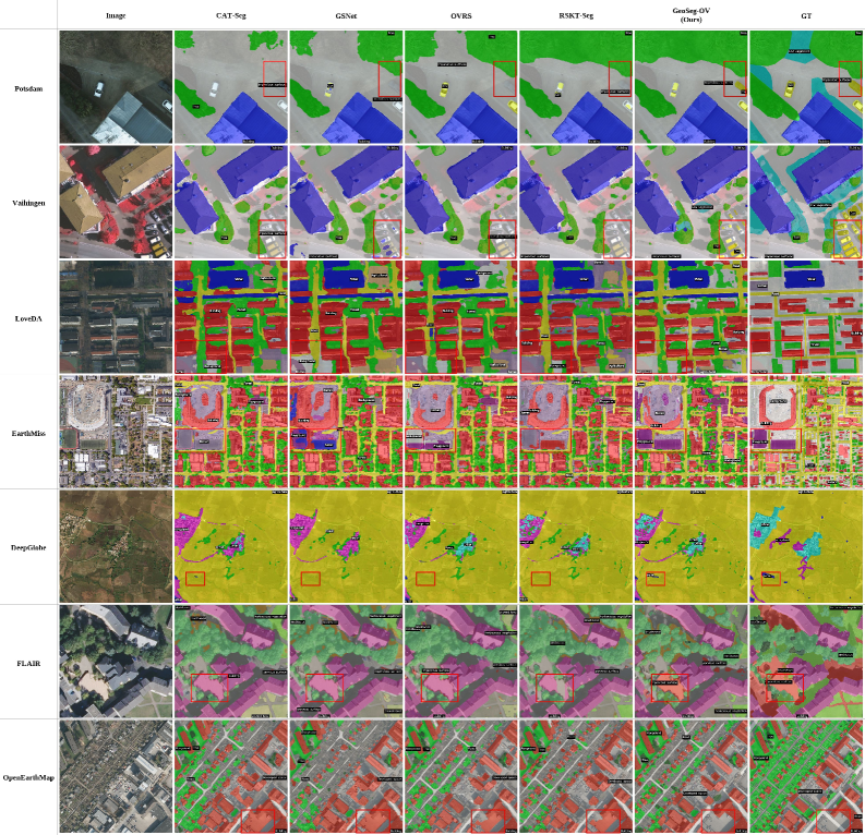
The largest improvements appeared where the geographic or resolution shift was most severe. That matters: a model that performs brilliantly only on imagery resembling its training set is an impressive laboratory experiment, but not yet a global mapping tool.
There are caveats. GeoSeg-OV is a preprint and has not yet passed peer review or independent replication. It is also not computationally weightless. The full configuration used 13.4 GB of GPU memory and took 0.31 seconds per inference iteration on an NVIDIA RTX 4090—slower than several comparison models.
Still, the direction is compelling. Fixed-category classifiers answer questions chosen when the model was trained. Open-vocabulary systems promise to answer questions chosen when the map is needed.
That is a subtle shift, but potentially a huge one. The future GeoAI interface might not begin with “select a classification model.” It may simply ask: What do you want to map today?
The authors have released the code and benchmark on GitHub.
How do you like this piece focused on GeoAI? Read more and subscribe to our monthly newsletter!


