Why Have Scientific Datasets Been So Widely Adopted in Earth Observation and What Role Does Data Quality Play?
Year after year, satellites soar into space, each following their respective orbits, observing our planet from above. As of March 7, 2024, there are 9494 active satellites in various Earth orbits, with 1052 of these dedicated to Earth observation missions.
Of the total satellites currently active, 72% are considered “small satellites, which cover super-microsatellites, microsatellites, and nanosatellites. This increasing availability of Earth observation data means that our eyes in the sky are continuously collecting, storing, and sending data back to Earth.
The sheer volume of EO data being generated, estimated at 20TB per day from the Sentinel satellites alone, poses significant opportunities and challenges. In addition, the combined fleet of Sentinel-1, Sentinel-2, and Sentinel-3 have been widely adopted across industries—particularly for AI uses. Using AI in EO has now evolved from being an opportunity to becoming a necessity. The exponential growth in data volumes has transformed AI into an indispensable tool. The sheer magnitude of information generated by satellites necessitates the use of AI technologies for rapid and precise data processing. Without AI, it would be virtually impossible to efficiently analyze and extract meaningful insights.
This leads us to ask questions such as:
How do we know what kind of data is useful? What exactly is EO data quality? Why have scientific datasets like Sentinel been so widely adopted?
Understanding the definition of data quality and why scientific data is so often used over commercial data is often left unaddressed in the industry—which is why we’re focusing on it in this article.
Before we begin though, it’s important to mention upfront that yes – scientific datasets are free. This is a huge reason for their widespread use. At the same time, scientific datasets are ideal for efficient processing by automated algorithms. We’ll look at this further down in the article.
What is data quality?
When we think about data quality, it’s usually assumed that it refers to the often-mentioned spatial resolution. It is, though, a lot more nuanced than that, with many factors playing a role.
Let’s take a closer look at what we can call the three pillars of data quality:
1. Accuracy
This implies that there are minimal or negligible errors in the data. This could be the radiometric accuracy of satellite data influenced by atmospheric conditions, shadows, and topographic effects.
The spatial accuracy of satellite data is another type to consider. This can be influenced by lens distortion and time synchronization issues, and data processing policies of different providers and that can be improved through ground control point referencing.
2. Completeness
How complete data is can also vary depending on what sort of completeness of data you are considering. Spectral completeness looks at the extent to which a satellite sensor can capture and represent the full range of electromagnetic radiation across different wavelengths or spectral bands. Can we see beyond the range of the human eye?
Coverage completeness in EO data refers to whether a satellite sensor has observed and captured data over the entire area of interest with minimal missing information or spatial gaps. Essentially, how well the Earth’s surface, atmosphere, and other target areas have been captured. Cloud cover is a major factor affecting the completeness and usability of optical satellite data.
Lastly, day/night observation completeness in terms of data quality measures the ability of satellite sensors to capture data effectively regardless of whether it is daytime or nighttime. To achieve day/night observation complements, satellites are equipment with various technologies and strategies such as sensors operating in the visible and near-infrared spectral bands for daytime observations to cover detailed information about coastal features, land cover, and other surface characteristics. Nighttime observations present unique challenges due to the absence of sunlight, however, satellite sensors equipped with thermal infrared and active sensing techniques, such as synthetic aperture radar (SAR), can capture data during nighttime hours.
3. Consistency
Data quality seen through the lens of how consistent it is can point towards characteristics such as the revisit rate, viewing angles, or sun angles. The revisit rate refers to the frequency with which a satellite revisits a particular location on the Earth’s surface. For example, a high revisit rate means that the satellite passes over the same area frequently. This provides more opportunities to capture data and monitor changes over time.
Consistency in revisit rates such as this ensures that data is collected regularly, ensuring the detection of short-term changes, such as natural disasters, land cover dynamics, and vegetation growth.
Viewing angles, also known as incidence angles, refer to the satellite’s ability to observe areas off its direct ground track by adjusting its orientation in space. This is related to the satellite’s “agility” – its ability to modify its attitude to observe scenes outside its ground track. Some satellites, such as monitoring missions, are consistently NADIR-looking, while other agile satellites image at different angles, including some offering oblique image tasking (point-and-shoot imagers).
Sun angles refer to the angle at which sunlight strikes the planet’s surface relative to the observer’s position. Sun angles vary throughout the day and the year as seasons change. This influences illumination conditions and whether shadows are present in satellite imagery.
Consistency in sun angles means that satellite data is collected under similar lighting conditions, ensuring accurate comparisons and analyses across varying periods can be done.
The conversation around consistency needs to include the pushbroom vs point and shoot factors in providing quality. Together with the orbit and hardware, these form the foundation for high-quality data.
Data quality depends on your specific needs
After considering the three pillars of data quality, it’s clear that whether you’re judging data by how accurate, complete, or consistent it is—ultimately the definition depends on your needs.
The definition of ‘high data quality’ for human eyes such as in visual mapping use cases will differ from what computer/AI eyes consider to be high quality when seeing things that can’t be discerned with human eyes.
These data quality requirements for different types of analysis are crucial to consider when asking yourself what high-quality data is.
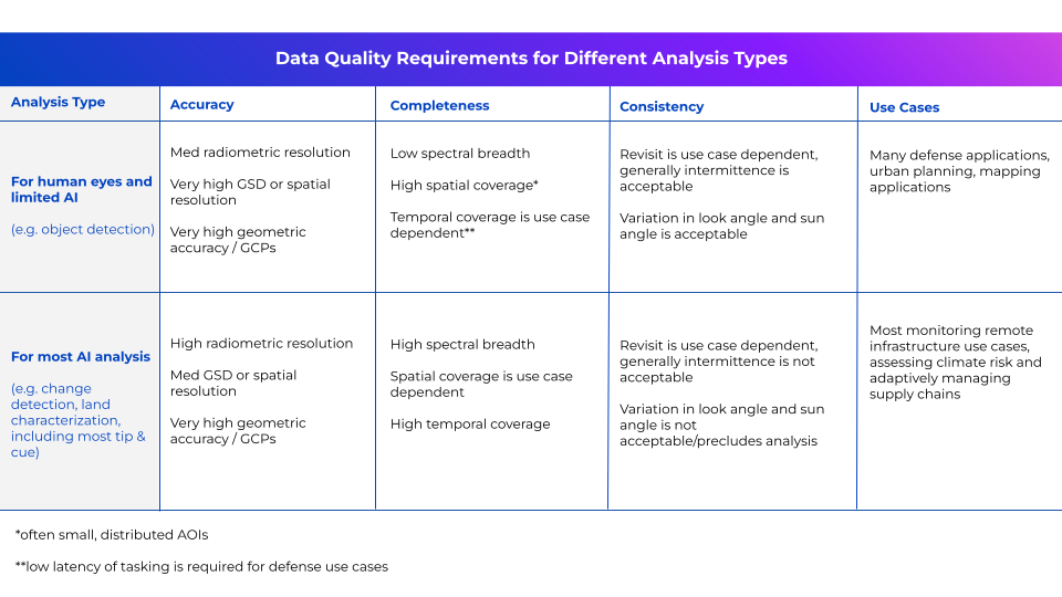 For most commercial data companies, high-quality data is usually seen as point-and-shoot tasking—looking at places at different times of the day with different elevation angles. This makes it difficult for computers to do analytics to extract information.
On the other hand, with many scientific satellites, such as the Sentinel fleet, there is no tasking, but rather a standardized acquisition that makes it not only easier to assess with analytics, but the results of those analytics are then more reliable and interpretable.
This is because the more variables that are controlled for in the measurement and observation, the better the measurement.
Why have scientific datasets been so widely adopted for AI?
The Sentinel fleet
As mentioned above, scientific satellites have standardized acquisition, which makes data access and analysis easier. The Sentinel satellites developed by the European Space Agency (ESA) as part of the Copernicus program, comprise a fleet equipped with different sensors and capabilities to monitor various aspects of the Earth’s environment. For example, Sentinel-1 consists of two C-band SAR satellites (Sentinel-1A and Sentinel-1B) that provide all-weather, day-and-night radar imaging for applications such as climate studies and emergency response. Sentinel-2 comprises a pair of optical imaging satellites (Sentinel-2A and Sentinel-2B) equipped with multispectral sensors that capture high-resolution imagery across 13 spectral bands, including visible and near-infrared. Sentinel-2 data is used for urban planning, water quality assessment, and forestry management.
The Sentinel satellites, as well as its esteemed American counterpart, the Landsat mission, contribute to a wide range of applications and are an invaluable tool for policymakers, scientists, and the public to make informed decisions and address global environmental challenges.
The importance of scientific datasets in AI applications
Satellite data is currently undergoing an AI revolution. Thanks to artificial intelligence and machine learning techniques, we’re able to extract insights much easier, quicker, and more reliably – than ever before. However, with this comes challenges. Let’s consider some of these and how the characteristics of scientific EO datasets meet these.
Deep Learning or Computer Vision:
Deep learning algorithms require large amounts of high-quality data for effective training. The main challenge with using these is the lack of large, labeled datasets for training the algorithms.
This is where scientific datasets shine. Scientific EO data’s consistency and completeness provide a robust training base for these algorithms, leading to more accurate and generalizable models in tasks like object detection, semantic segmentation, and image classification.
Deep learning models are particularly data-hungry. They typically require thousands of labeled images per class to achieve good performance. The vast archives of historical data available from scientific EO missions provide a significant advantage over commercial EO data, which may have limited temporal coverage or focus on specific areas of interest—which inherently creates bias in a neural network.
Anomaly or Change Detection:
Consistent and accurate data allows AI models, particularly change detection, to compare feature representations across time that generalize well to unseen data.
Variations in commercial EO data, such as those arising from different sensors, viewing geometries, or illumination conditions, can lead to models that overfit specific acquisition conditions and perform poorly in any case of multi-temporal analysis. Such variations mean that doing anomaly or change detection on commercial sets can often lead to inaccuracies and can be a lengthy process.
In contrast, the standardized nature of scientific EO data ensures that the features observed in the AI and any changes detected are meaningful and transferable across different locations and time periods.
Clustering:
Unsupervised learning techniques like clustering rely on identifying inherent groupings within the data. Clustering is widely used for analyzing and extracting insights from data so that patterns, structures, and relationships can be identified. A key challenge in applying clustering is dealing with data with high dimensionality, noise, and missing values.
The standardization of scientific EO data means that identifying meaningful clusters representing natural phenomena is easier than with commercial datasets. With its variations in acquisition parameters, commercial data inconsistencies can lead to clusters that are artifacts of these variations rather than true underlying patterns.
For example, a clustering algorithm applied to commercial EO data with varying sun angles might identify clusters that correspond to these sun angle variations instead of actual land cover types.

Commercial adoption of scientific datasets
Scientific datasets like Sentinel have been widely adopted by companies in sectors such as agriculture, insurance, land management, and water resource management. Why is that?
1. Availability and accessibility
Scientific datasets such as the Sentinel satellites provide “free and openly accessible EO data”. Such an open-access model encourages a wider user community to access and derive insights from satellite data. This includes commercial companies looking to innovate in their fields of interest by tapping into large volumes of free and high-quality EO data.
This availability and accessibility means that new opportunities are opening up in the commercial world for satellite data to be used by people who are new to the industry, beyond just experts.
2. Data characteristics and quality
Considering the technologically diverse nature of each of the Sentinel satellite’s sensors, advanced instruments such as the Sea and Land Surface Temperature Radiometer (SLSTR), provide high-quality data that can be costly and tricky to find elsewhere.
Another important data quality characteristic to consider is the ability of active sensors like SAR to provide reliable data regardless of cloud cover or day/night conditions—a key advantage for many commercial applications.
3. Diverse applications
Scientific datasets usually come with an incredibly wide range of potential commercial applications, including forestry, fishing, energy, insurance, urban development, agriculture, and many more.
This combination of EO data with other types of non-space data can lead to innovative commercial user applications and insights. Essentially, companies can use scientific datasets as their reliable and resourceful tool in their product-building toolbox.
4. Cost-effectiveness
When starting a business from scratch or scaling one already grown, cost-effectiveness is an important factor driving the adoption of scientific EO datasets by commercial companies.
Having free and open-access EO data with the click of a button is a game-changer for many businesses today. Scientific datasets such as Sentinel can provide better value for money compared to commercial data procurement, especially when purchased in larger quantities. Satellite data is traditionally known to be notoriously difficult to access, with many hoops to jump through and costs to consider. Scientific datasets, on the other hand, offer a low-risk way to create EO products and services overnight.
Some companies using scientific datasets to make an impact include:
- Orbital Eye uses Sentinel-1 for their CoSMiC-EYE solution which automatically processes all collected satellite data, and its algorithms detect activities that could potentially damage pipelines. The technology uses change detection algorithms to detect third-party interferences in the pipeline corridor—automatically producing a change map.
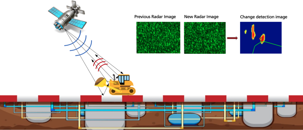
Classical- and AI-based filtering of irrelevant changes (Orbital Eye)
2. Pachama uses ESA’s Sentinel-2 and NASA’s GEDI (Global Ecosystem Dynamics Investigation) lidar for their forest height and carbon mapping. They observe the “greenness” of the forest canopy thanks to Sentinel-2 optical-infrared data, painting a picture of the amount of leafy material and chlorophyll present. The picture is complete when combined with NASA GEDI data, mounted on the International Space Station. GEDI lidar produced a vertical profile of the forest, bringing 3D structural information to enable Pachama to improve the accuracy of their forest carbon mapping.
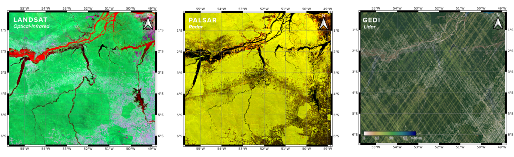
Pachama uses three types of space-borne observations to map canopy height and carbon over large regions (optical-infrared, radar, and lidar). (Pachama)
3. EarthDaily Agro uses ESA’s Sentinel-2 and other data sources to feed their precision agriculture, crop insurance, and commodity trading analytics. By integrating the Sentinel-2 data with other satellite sources like Landsat, EarthDaily Agro gains a comprehensive, high-frequency view of agricultural conditions globally. As a result, they provide timely insights to customers across industries. For crop insurance, EarthDaily Agro leverages Sentinel-2 data to verify planting dates, track crop progress, and forecast yields.
Their cloud-based platform simplifies the process of accessing and integrating Sentinel-2 data for customers creating their own applications and models.
How can we bridge the market gap between scientific datasets and commercial datasets to unlock more AI applications?
1. Recognize where needs are being met and where they aren’t
Earlier, we discussed several use cases where scientific datasets are successfully leveraged to solve pressing global challenges. As for commercial datasets, one well-proven example. Urban planning projects benefit from high spatial resolution data for frequent and detailed monitoring of urban development and infrastructure changes. Comprehensive snapshots of the area, even with just one or two images per year can suffice.
For example, a city might use commercial datasets to monitor the construction progress of new buildings or to document informal settlements. This use case for existing commercial datasets is viable for several reasons: 1) urban areas are more frequently imaged by commercial providers, and 2) the relatively small area under observation means pre-processing demands can be minimal, making human-in-the-loop analysis feasible.
In contrast, scientific datasets, while beneficial, fall short in certain applications like orchard monitoring. Consistent imaging at the same time of day is crucial for orchard management to ensure constant temperature and spectral signatures, which are vital for accurately monitoring tree health and growth.
These high-quality sensors provide good spectral information necessary for assessing vegetation health, detecting diseases, and managing irrigation. However, the infrequent acquisition of these satellites is a significant limitation. Growers, crop insurers, and commodity traders need to monitor critical changes such as flower emergence, pest infestations, and moisture levels, which can occur rapidly and require timely intervention.
The relatively infrequent revisits of scientific datasets may miss these crucial moments, leading to delayed responses and potential yield loss. Additionally, the spatial resolution might not be sufficient to detect small-scale changes in individual trees or rows, which are often essential for precise orchard management.
2. Improve data interoperability between commercial and scientific datasets
One key way to bridge the market gap between scientific and commercial Earth observation datasets is to focus on data interoperability.
Scientific datasets like Sentinel offer high-quality, consistent, and openly accessible data, while commercial datasets often provide more specialized or customized data products tailored to specific industry needs.
By developing standards and protocols that enable seamless integration and exchange of data between these two data ecosystems, businesses can leverage the strengths of both to create more comprehensive and powerful AI applications.
This could involve standards in accessibility like SpatioTemporal Asset Catalog (STAC) and standards in data quality like Analysis Ready Data (ARD) across commercial data providers, as well as greater or improved API accessibility for scientific datasets.
3. Create new commercial satellites with standardized acquisitions
How can the integration of consistent acquisition times and high-frequency data collection improve the accuracy and reliability of AI models in earth observation, and what new applications could this enable?
One company in particular, EarthDaily, posits that the advancements in imaging technology with enhanced spectral breadth and signal-to-noise ratios, combined with scientifically accurate satellite calibration and processing, can revolutionize change detection and AI integration in the EO market, particularly in sectors underserved by existing datasets.
For example, this new dataset could address the aforementioned orchard flower or disease emergence detection problem. Another application is disaster response. Companies can leverage high revisit rates and high spectral resolution data, like existing commercial datasets, for disaster response by focusing on the rapid and detailed monitoring of affected areas.
When the location of a disaster is known, and a large company has a significant contract with various providers, timely acquisition of a tasked dataset becomes feasible. For instance, in the aftermath of a natural disaster such as a hurricane or earthquake, existing commercial datasets can quickly assess the extent of damage to infrastructure, monitor the progression of floodwaters, and identify areas that require immediate humanitarian assistance.
The high revisit rate ensures that changes are captured frequently, allowing responders to track the situation as it evolves and deploy resources more effectively. This frequent and detailed data collection supports better decision-making in real-time, enabling a swift response to mitigate further damage and coordinate relief efforts.
The high spectral resolution also aids in distinguishing between different materials and assessing the impact on vegetation, buildings, and roads, providing comprehensive situational awareness that is crucial for effective disaster response.
However, significant limitations arise when the disaster’s location is unknown, or the issue requires broad-area analysis, ruling out reliance on human-in-the-loop analysis.
This is the case with drought monitoring, pest and disease monitoring, many maritime risk use cases, and more.
With the advent of a new dataset that integrates the consistent acquisition model and data quality of scientific datasets with high-frequency revisit and improved spatial resolution akin to commercial datasets currently available on the market, Earth observation users could monitor broad areas, reliably and efficiently with AI.
Once an area of concern is identified, they could cue the acquisition of one of the many responsive commercial datasets with higher spatial resolution to zoom in on the issue and provide comprehensive situational awareness.
Conclusion
The Sentinel and Landsat missions underscore the pivotal role of scientific datasets in driving innovation and addressing global challenges through AI-enabled analysis.
However, while these datasets offer unparalleled accessibility, global coverage, and consistency, there remains a critical gap in the market concerning the resolution and revisit frequency required for early change detection and dynamic monitoring. Bridging this gap will unlock new opportunities for leveraging EO data in commercial applications, enabling more effective and timely insights into our dynamic planet.
What’s clear though, is that the industry continues to scour terabytes of imagery captured by scientific fleets to meet their and their customers’ needs. Where will the next 5-10 years take us? We look forward to finding out!
This article was produced in collaboration with EarthDaily Analytics and co-authored by Nikita Marwaha Kraetzig and C. Elizabeth Duffy.
Did you like the article? Read more and subscribe to our monthly newsletter!


#Featured


Next article
2024’s Best Offline Map Apps: Ultimate Guide for Travel and Navigation
In today’s world, where connectivity is a constant companion, offline map applications have become an integral tool for travelers and adventurers.
Whether navigating through a foreign city, hiking in remote areas, or preparing for emergencies, offline maps ensure you always know where you are, even without an internet connection.
We’ve compiled the best offline map applications of 2024, comparing their features, usability, and accuracy. We’ll equip you with the knowledge to choose the perfect digital navigator for your adventures, whether you’re behind the wheel, on two wheels, or on foot.
Why Are Offline Maps So Important?
Offline maps are crucial for several reasons, beyond mere convenience:
- Reliability: Offline maps are free from the constraints of cellular networks and Wi-Fi hotspots. They don’t rely on these and are essential when navigating in areas with poor connectivity.
- Cost-Effective: By eliminating the need for data roaming when traveling internationally, offline maps help to reduce charges traditionally associated with using data abroad.
- Battery Efficient: With reduced data fetching, offline maps significantly extend your device’s battery life—a crucial factor for long journeys or remote areas.
- Safety: In emergencies, offline maps provide a reliable fallback, ensuring you can always find your way to safety.
5. Enhanced Exploration: Free from connectivity concerns, with offline maps, you can venture off the beaten path with confidence. Discover hidden gems and forge new experiences.
The Best Offline Maps For Drivers
In a time when connectivity isn’t always guaranteed, offline maps have become essential tools for drivers. Let’s explore the top contenders:
Google Maps: The All-Rounder
Key Features:
- Comprehensive global map coverage
- Offline area downloads for specific regions
- Real-time traffic updates when online
- Intuitive route planning and navigation
Usability:
A household name, Google Maps offers an extremely user-friendly interface that’s familiar to most smartphone users Maps can be downloaded easily by selecting the area you wish to save for offline use.
Accuracy:
Thanks to Google’s extensive mapping data and frequent updates, Google Maps is highly accurate, even in offline mode.

Source: Google Support
Waze: The Crowd-Sourced Navigator
Key Features:
- Real-time, user-generated traffic and road condition updates
- Limited offline capabilities compared to Google Maps, requiring initial connection before driving offline, but still useful
- Community-driven alerts for traffic updates, road hazards, police presence, and more
Usability:
Waze is designed with drivers in mind, providing alternate routes quickly based on current traffic conditions. Its interface is intuitive and driver-friendly.
Accuracy:
While primarily an online tool, Waze’s accuracy shines through its real-time user input, providing up-to-the-minute traffic and road change information.

Source: Waze
HERE WeGo: The Offline Champion
Key Features:
- Extensive offline functionality
- Ability to download entire countries or regions
- Turn-by-turn navigation in offline mode
- Public transport information included
Usability:
HERE WeGo boasts a clean, simple interface that’s easy to navigate. Its robust offline capabilities make it a great choice for international travelers or those venturing into areas with poor connectivity
Accuracy:
Known for its reliability, HERE WeGo offers accurate navigation and a wide range of offline features.
Source: HERE
The Best Offline Maps For Tourists
In today’s digital age, tourists need reliable navigation tools. Here’s a selection of top-tier map apps designed to help you explore during your travels:
Citymapper: Your Urban Exploration Companion
Key Features:
- Focused on urban transportation with detailed public transport information
- Offline maps available for major global cities
- Multimodal route planning (public transport, walking, cycling)
Usability:
Citymapper shines with its intuitive interface, tailored for effortless navigation in unfamiliar urban environments. Its focus on multimodal transport options makes it ideal for city tourists.
Accuracy:
With its covered cities, Citymapper offers highly accurate navigation, providing real-time updates where available online.
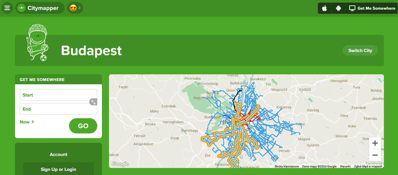
Source: Citymapper
Tripadvisor: More Than Just Reviews
Key Features:
- Offline access to city maps, reviews, and photos
- Information on attractions, restaurants, and hotels
- Downloadable content for 300+ cities globally
Usability:
Known for its travel planning features, TripAdvisor’s app seamlessly integrates its database of reviews and recommendations with offline mapping capabilities making it a handy tool for tourists.
Accuracy:
While primarily known for its user-generated content, TripAdvisor’s offline maps provide accurate location data for points of interest and general navigation.
YT video instruction: How to download offline Tripadvisor maps
MAPS.ME: Global Offline Navigation
Key Features:
- Detailed offline maps covering the entire world
- Rich point of interest (PO) database to discover attractions, restaurants, hotels, and more offline
- Multi-modal navigation providing turn-by-turn directions
- Regular map updates and community-driven improvements
Usability:
MAPS.ME’s intuitive interface caters to both urban explorers and off-the-beaten-path adventurers. The app’s focus on detailed offline functionality makes it exceptionally user-friendly.
Accuracy:
Known for its precision, MAPS.ME leverages OpenStreetMap data, which is updated daily by millions of contributors. This crowdsourced approach ensures that maps remain current and accurate, even for lesser-known locations.

Source: MAPS.ME
The Best Offline Maps For Cyclists
For cyclists, having reliable navigation tools is crucial, especially when venturing into unfamiliar areas or when on long-distance rides. Here are a few of the top-tier offline map apps designed to improve the cycling experience:
Komoot: The Outdoor Enthusiast’s Choice
Key Features:
- Detailed offline maps with elevation data and surface-type information
- Sport-specific route planning optimized for road cycling and mountain biking
- Turn-by-turn voice navigation
- Community-driven highlights and recommendations
Usability:
Komoot offers an intuitive interface focused on route planning, discovery, and sharing. Its offline functionality is robust, allowing cyclists to download entire regions for offline use.
Accuracy:
Highly accurate, particularly for outdoor trails and cycling-specific routes. Komoot’s maps are regularly updated with community input, ensuring up-to-date information
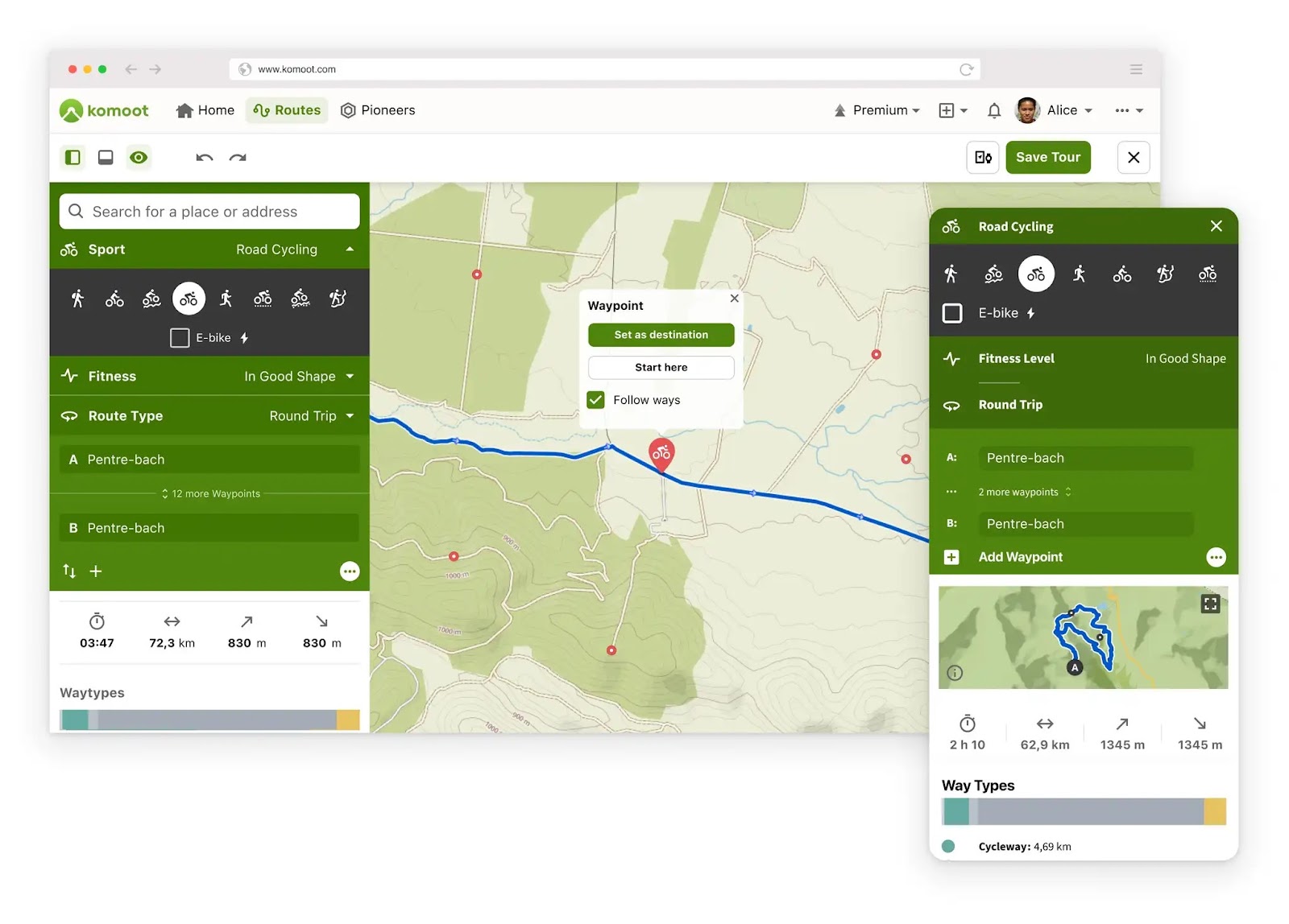
Source: Komoot
Strava: The Athlete’s Guide
Key Features:
- Offline maps integrated with fitness tracking
- Segment challenges and performance analysis
- Route creation and discovery
- Social features for sharing rides and achievements
Popular among athletes, Strava offers route tracking and offline maps for cycling. It integrates with fitness tracking.
Usability:
Popular among athletes, Strava’s Intuitive interface has a strong focus on performance tracking and social sharing of routes and achievements. Offline maps are easily accessible for route navigation.
Accuracy:
Known for its precise route tracking and elevation data, Strava provides accurate and reliable navigation and performance metrics for cyclists.
Source: Strava
Ride with GPS: The Cyclist’s Navigator
Key Features:
- Detailed offline maps with cycling-specific route information
- Turn-by-turn navigation with voice prompts
- Comprehensive elevation profiles
- Custom cue sheets and route planning
Usability:
Designed with cyclists in mind, Ride with GPS offers straightforward route planning and navigation. Its offline capabilities are extensive, catering to long-distance riders.
Accuracy:
Highly accurate, providing detailed elevation data and route information.
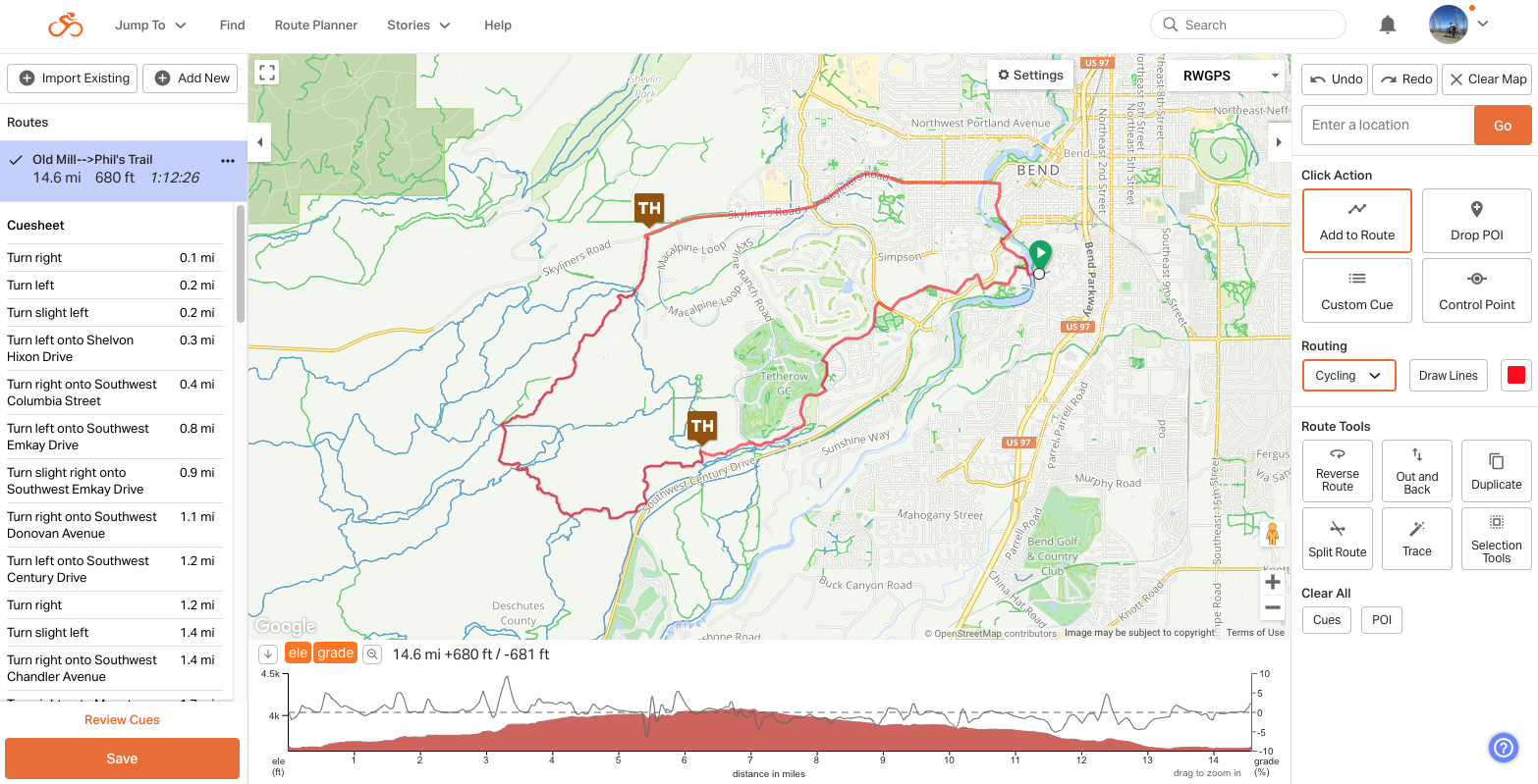
Source: Ride with GPS
The Best Offline Maps For Motorcyclists
For bikers who love to explore the open road, here are a few of the best apps for your off-the-grid adventures:
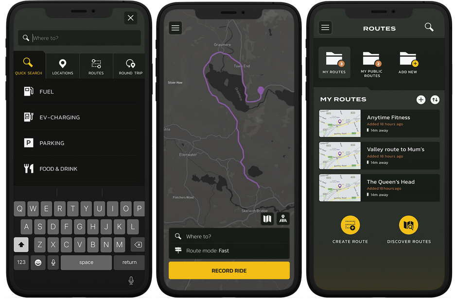
REVER: Route Planning Made Easy
Key Features:
- Detailed offline maps with motorcycle-specific route planning
- Community-shared routes and ride discoveries
- Comprehensive ride tracking and performance metrics
- Weather overlay for intelligent route planning
Usability:
REVER has an intuitive, user-friendly with a focus on scenic routes and ride tracking.
Accuracy:
Highly accurate for road conditions and route planning, benefitting from regular updates and community input
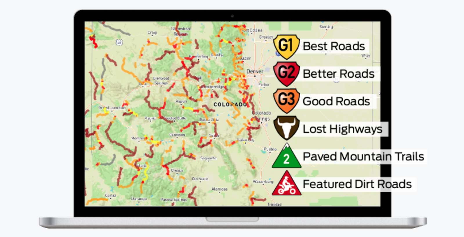
Source: Rever
Scenic: Discover the Road Less Traveled
Key Features:
- Curated scenic routes optimized for motorcycles
- Robust offline map access for remote areas
- Points of interest specific to bikers (e.g motorcycle-friendly stops, viewpoints)
- Route sharing and community recommendations
Usability:
Scenic’s user-friendly design focuses on helping bikers discover and navigate picturesque routes with ease, even without an internet connection.
Accuracy:
Highly accurate with a focus on scenic and enjoyable routes, with regular updates to ensure accuracy
Source: Scenic
The Best Offline Maps For Walkers
Whether you’re exploring urban trails or venturing into remote wilderness, these apps will help you stay on track without an internet connection:
AllTrails: For the Trail Explorer
Key Features:
- Vast library of 400,000 trail maps worldwide
- Detailed offline maps with elevation profiles
- User-generated reviews and condition updates
- Custom route creation and recording capabilities
AllTrails is perfect for hiking and walking, offering detailed offline maps with trail information and user reviews.
Usability:
Perfect for hiking and walking, AllTrails is user-friendly with a focus on trail details, difficulty levels, and reviews. The app is made for both daily walkers and regular hikers.
Accuracy:
Highly precise trail trail maps, enhanced by user-submitted data and regular updates.
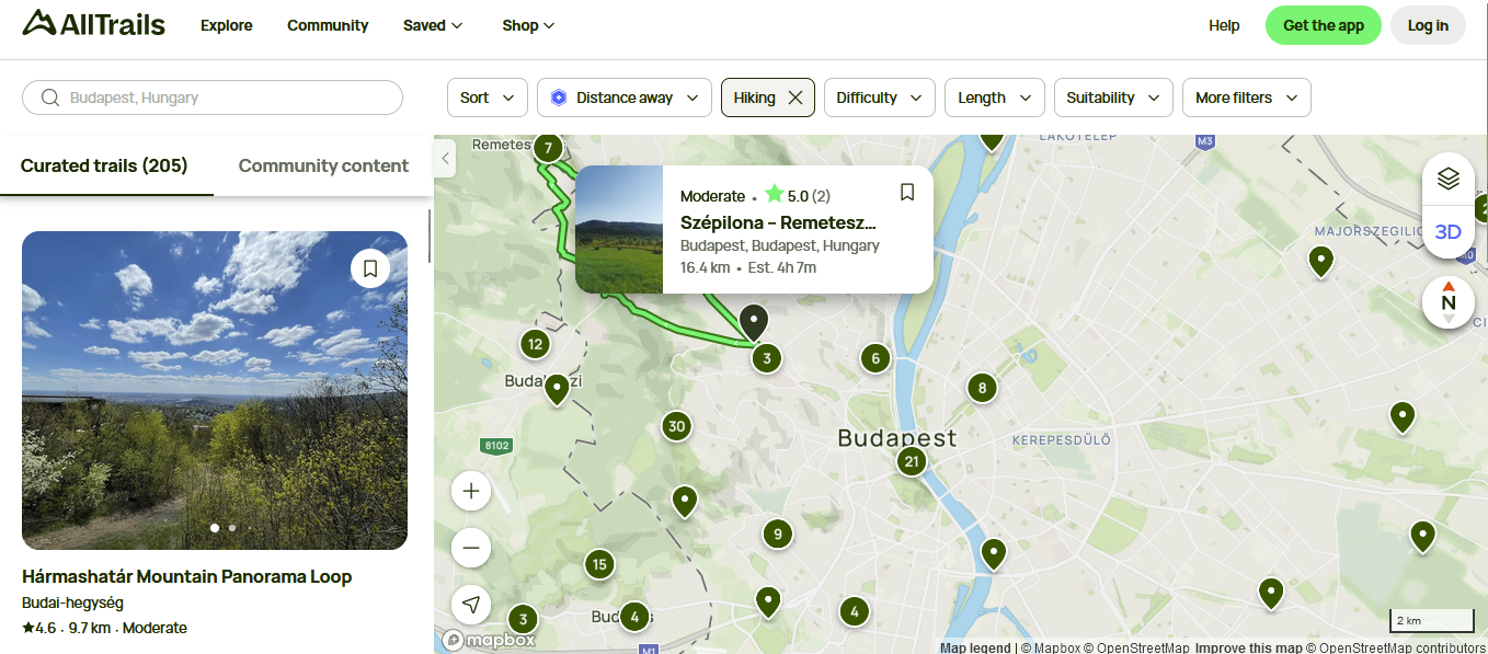
Source: AllTrails
Komoot: The All-Terrain Navigator
Key Features:
- Detailed offline maps for hiking and walking with terrain and surface information
- Sport-specific route planning with turn-by-turn voice navigation
- Personalized route suggestions based on fitness level and preferences
- Community tips, highlights, and route sharing capabilities
Usability:
In addition to cyclists, Komoot is great for walkers and hikers. It’sasy to use with detailed route planning and offline capabilities for both beginners and experienced hikers.
Accuracy:
Accurate with detailed trail and walking route information thanks to OpenStreetMap data and community contributions Komoot’s sport-specific routing ensures accurate suggestions for walkers and hikers.
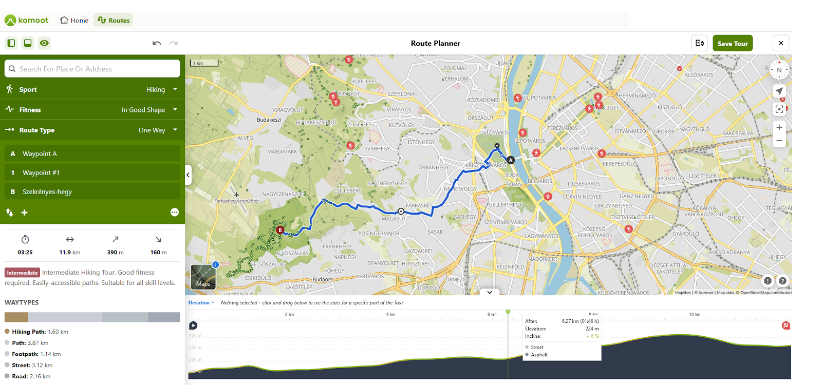
Source: Komoot
MapMyWalk: Fitness Meets Navigation
Key Features:
- Route tracking and offline maps for walking and hiking
- Integration with fitness tracking and goal setting
- Community-shared routes and challenges
- KML export for Google Earth visualization
Usability:
MapMyWalk offers an intuitive interface that combines navigation with comprehensive fitness tracking features. It’s particularly useful if you’re looking to monitor your progress and set fitness goals.
Accuracy:
Accurate for route tracking and distance measurement. The app’s GPS tracking ensures accurate stats for your walks and hikes.
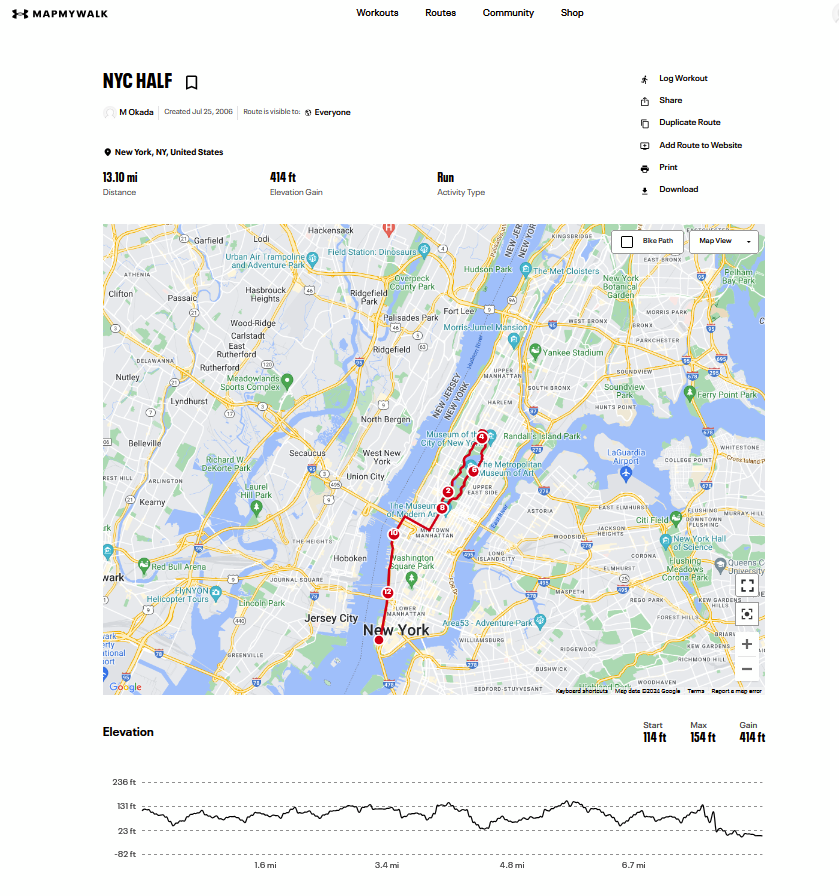
Source: MapMyWalk
KML route in Google Earth
Navigating the Future: Offline Maps for Every Adventure
Offline map applications are essential tools for anyone needing reliable navigation without constant internet access.
Whether you’re a diver, a tourist wandering new streets, a cyclist exploring new trails, a motorcyclist cruising scenic routes, or a walker navigating nature’s paths, there’s an offline map app tailored to your needs.
These digital tools offer more than just directions, they provide peace of mind, enhance safety, and open up new possibilities for exploration.
We hope this guide has helped you to compare features, usability, and accuracy—so you can choose the best app for you.
What apps do you use in your daily life? And what features do you appreciate the most? Tell us in the comments
Read more about navigating apps in Top offline GPS navigation apps to download before your next road-trip.
Did you like the article on Offline Map Apps? Read more and subscribe to our monthly newsletter!

