

The UN Biodiversity Lab – a partnership between the United Nations Development Program (UNDP) and the UN Environment – is an initiative that provides high-quality geospatial data to government representatives of more than 140 countries. The platform offers more than 100 global spatial datasets on biodiversity, protected areas, sustainable development, and human pressure using MapX open-source cloud solution.
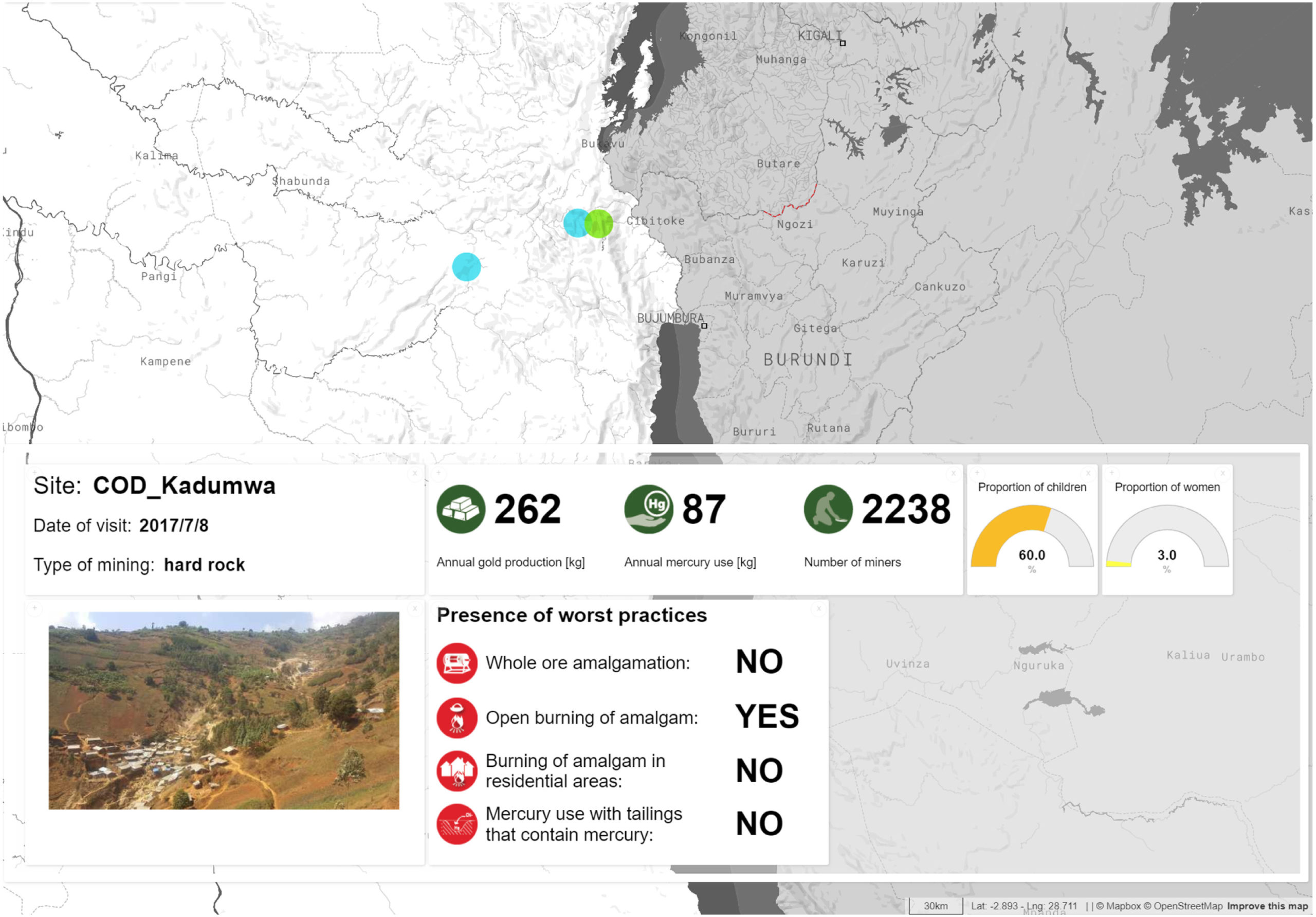
Example of MapX story map with narrative, picture and dynamic map, aiming at improving the understanding of a fieldwork assessment of the consequences of mining actions driving mercury pollution of sediments and water in DRC
What MapX does is that it acts as a bridge between data providers and data users. The mapping dashboard collates spatial data from the UN Environment World Conservation Monitoring Centre, the Global Resource Information Database (GRID-Geneva), NASA, UN agencies, and premier research institutions to ensure that governments across the world have access to the data they need to make key conservation and development decisions.
It should be noted that MapX is the only UN-backed geospatial mapping software that collects and verifies scientific data, brokers knowledge exchange for people in need of spatial solutions to environmental and natural resource challenges, and offers a customizable toolkit for analysis, visualization, and sharing. And it seems to be working.
A June 2019 analysis of 77 ‘Sixth National Reports’ submitted to the UN Biodiversity Convention has revealed that the number of maps in the 6NR reports has doubled and that 30 percent of the participating countries have used UN Biodiversity Lab to produce at least one of their maps.
In Bhutan, for example, MapX helped to bring the hydropower energy and the conservation sector together. With map visualizations laying bare the potential impacts on the ecosystem, planned hydropower projects were downsized and alternatives explored – one of which is to reallocate part of the hydropower energy revenues to targeted upstream land use management programs and ensure regular and reliable water flow and deliver benefits to local communities.
In the Philippines, MapX has allowed policymakers to explore proposed land reclamation projects in Manila Bay as well as the ecosystems that may be lost as a result. Eventually, a moratorium on land reclamation was put out, with arguments from the geospatial analysis.
Meanwhile, Tanzania has been able to ‘nature-proof’ agricultural development when spatial analysis showed that drip irrigation could improve resilience as well as overall food security.
You can explore all these examples and more in this MapX story map.


#Environment


Next article
In a turn of events that the world hoped would never come, war has returned to Europe: February 24 saw the beginning of a terrible and unprovoked invasion of an independent country by Putin’s Russia. In amongst the many horrors to have unfolded since there has been one particularly fascinating development for those of us in the geospatial community—the role played by Google Maps.
Of course, maps and geographic data have been critical elements of warfare for centuries, while Google Maps, as a tool, is used by billions of people around the world each day. Not until now have the two collided quite so dramatically.
Google Maps and its difficult balancing act
Before the conflict even started, Google found itself in an uncomfortable position. Towards the end of 2021, the Kremlin—a longstanding critic of American tech platforms and the freedom inherent in social media—stepped up its campaign against Big Tech. Google were issued with a $100 million fine for failing to bow to Moscow’s demands to remove ‘banned content’.
Russia had been aggravated by Google’s resistance to censorship, as well as its supposed support of Kremlin critics—including hosting a voting tool app created by Putin’s rival Alexei Navalny, which Russia claimed amounted to electoral interference. (It is a common Kremlin tactic to draw a false equivalence between providing services to Putin’s political opponents and interfering with elections.)
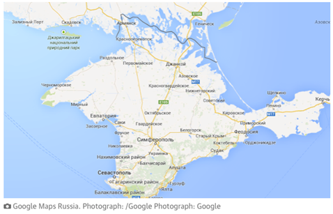
Google’s main concession to these objections was to mark Crimea as Russian territory for those viewing Google Maps in Russia while leaving it as ‘neutral’ for those in Ukraine.
Since the beginning of the war, many big multinational corporations (including Coca-Cola, McDonald’s, Apple, and Meta) have withdrawn operations and services in Russia, and on March 10, Google announced that it would follow suit, pausing all paid services and monetization features in the country, including Play Store and YouTube.
That hasn’t stopped people using its free services, both within Russia and outside it, for strategic purposes—with four of the most interesting uses detailed here.
On Maneuvers
In the early hours of February 24, 2022, researchers in Vermont noticed that user-generated information on Google Maps showed unexpected traffic behavior at the Russian-Ukrainian border. Specifically, a long traffic jam near Belgorod—in the same place that a large Russian military convoy had been located with radar just a day before. The traffic jam indicated a line of many vehicles on the roads—characteristic behavior for a military unit readying for an attack.
User data indicated that the traffic jam then began to move south—in other words, towards Ukraine—and all this before the invasion had been officially declared.
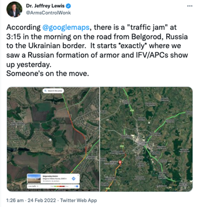
Twitter Traffic Jam on Ukrainian Border Russian Invasion Feb 24 2022
After some time, Google temporarily turned off global access to traffic data in Ukraine, a decision taken with the safety of Ukrainian citizens in mind. After all, if the American university team were able to discern Russian troop movement, it is all but certain that Russian military forces could have used the same method to predict the movements of Ukrainian civilians, which was of particular concern when considering the evacuation of refugees.
Strategic Planning
On February 25, news outlet Kyiv Independent alerted Ukrainian citizens, through a tweet, that ‘some signs have been painted to guide Russian bombers’ and ‘to check for and obscure any markings on the roofs’.
Fears that the Russian military was indeed weaponizing Google Maps appeared to come true when rumors began to spread that the secret service had employed digital markers as well as physical, using the tool to indicate strategic targets. (If changes are made either by a highly-rated guide or by multiple accounts, Google Maps are likely to be updated accordingly.)
One particular story was that the word ‘Edemus’ was used to mark places where rockets and bombs should be targeted—hospitals, schools, kindergartens and other important locations—apparently as some sort of grim joke, given that Edemus is a Ukrainian funeral home company.
Ukraine’s intelligence service did eventually debunk these rumours, but not before Google had responded to a huge campaign from users urging them to look into the issue. According to the company, any new user-generated content added within the borders of the war’s protagonists since the conflict started is being removed, ‘out of an abundance of caution’.
Information campaign by Google Maps
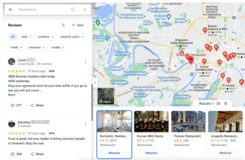
One of the most resourceful uses for Google maps has been attempting to disseminate information to Russian citizens who are largely kept in the dark by the Kremlin’s propaganda machine. On February 28, a tweet from account @Konrad03249040 was posted, which read:
Get involved: find a random shop/cafe/restaurant in Russia in big city on google maps and write in the review what’s really happening in Ukraine. Please spread the idea.
The post was later retweeted by hacktivist collective ‘Anonymous’, (to over 270,000 followers) and subsequently shared on a subreddit, receiving hundreds of upvotes, with plenty of people across the globe acting on the advice, spamming Google and TripAdvisor with fake reviews.
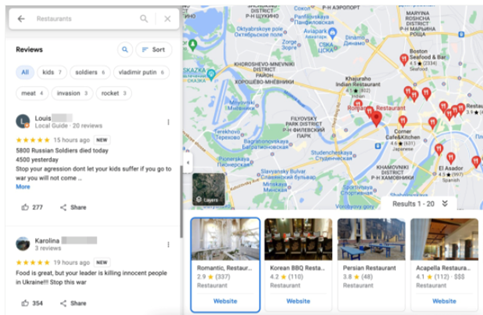
Google Maps Comments Anti Russia Invasion over Ukraine
Google acted quickly to prevent the site being used in this way—although this in itself was controversial—by temporarily blocking the publication of new reviews (or other content) on Google Maps, for locations in Russia, Ukraine and Belarus.
‘Due to a recent increase in contributed content on Google Maps related to the war in Ukraine, we’ve put additional protections in place to monitor and prevent content that violates our policies for Maps,’ a spokesperson said.
Military secrets
Given Russia’s past accusations, it’s perhaps no surprise that Google themselves were accused of acting in a partisan manner. On April 18, a Ukrainian twitter account claiming to represent the armed forces shared a series of images showing Russian military equipment and strategic military locations. The images were accompanied by a message that implied Google had ‘unblurred’ the satellite pictures of these locations.
It’s true that many military installations in Russia are indeed viewable on Google Maps, but Google’s response is that it did not make any alterations to the way satellite images are censored.
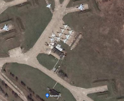
Google Maps Blurring Russian Millitary bases
In fact, Google does blur the maps of some sensitive areas (a French air force base, for example) but not others (Area 51 in Nevada is fully visible!).
Of course, although it makes a nice story, the Ukrainian military has access to intelligence and satellite imagery far beyond anything publicly available on Google, and not subject to any modifications.
Through the fog of war
Maps and other geographical data have always been key to warfare and military strategy, as has technology, and satellite imagery itself is not new. What is new, however, is the democratization of that information.
The wide availability of technology, and more specifically, satellite data, means that the act of gathering (and disseminating) information on active conflicts is no longer restricted to those who possess specialized military equipment, and therefore does not remain exclusively the domain of governments and their militaries. Citizens around the world are able to see, in near-real-time, the maneuvers of military vehicles and personnel, as well as using that technology to communicate with each other.
Where this technology goes next—and what tech giants like Google do to control it—is unknown. What we do know is that in an era of fake news and misinformation from authoritarian regimes, open-access geospatial data perhaps presents one of the best ways to see clearly through the fog of war—and yet, on the other hand, presents still more propaganda for us to decode.
Did you like this post? Read more and subscribe to our monthly newsletter!

