Geo Geek Gift Guide
#Fun #Ideas

The Geo Geek Gift Guide: 10 Unique Ideas for Every Geospatial Enthusiast

The holiday season is here, and it’s the perfect time to surprise the geography and map lovers in your life with something truly special. No matter if you’re looking for a thoughtful gift for a friend, a special treat for a family member, or even something just for yourself, we’ve put together a list of 10 unique ideas that celebrate the wonders of our planet and beyond.

We’ve picked out some great options from small businesses and sustainable initiatives, so you can feel good about your holiday shopping – it’ll bring joy to your loved ones and support good causes around the globe.

Here’s your guide to geo-inspired gifts that are perfect for Christmas and beyond.
The holiday season is here, and it's the perfect time to surprise the geography and map lovers in your life with something truly special. No matter if you're looking for a thoughtful gift for a friend, a special treat for a family member, or even something just for yourself, we've put together a list of 10 unique ideas that celebrate the wonders of our planet and beyond. We've picked out some great options from small businesses and sustainable initiatives, so you can feel good about your holiday shopping - it'll bring joy to your loved ones and support good causes around the globe. The Geo Geek Gift Guide

10 Thoughtful Gifts for Geo Geeks

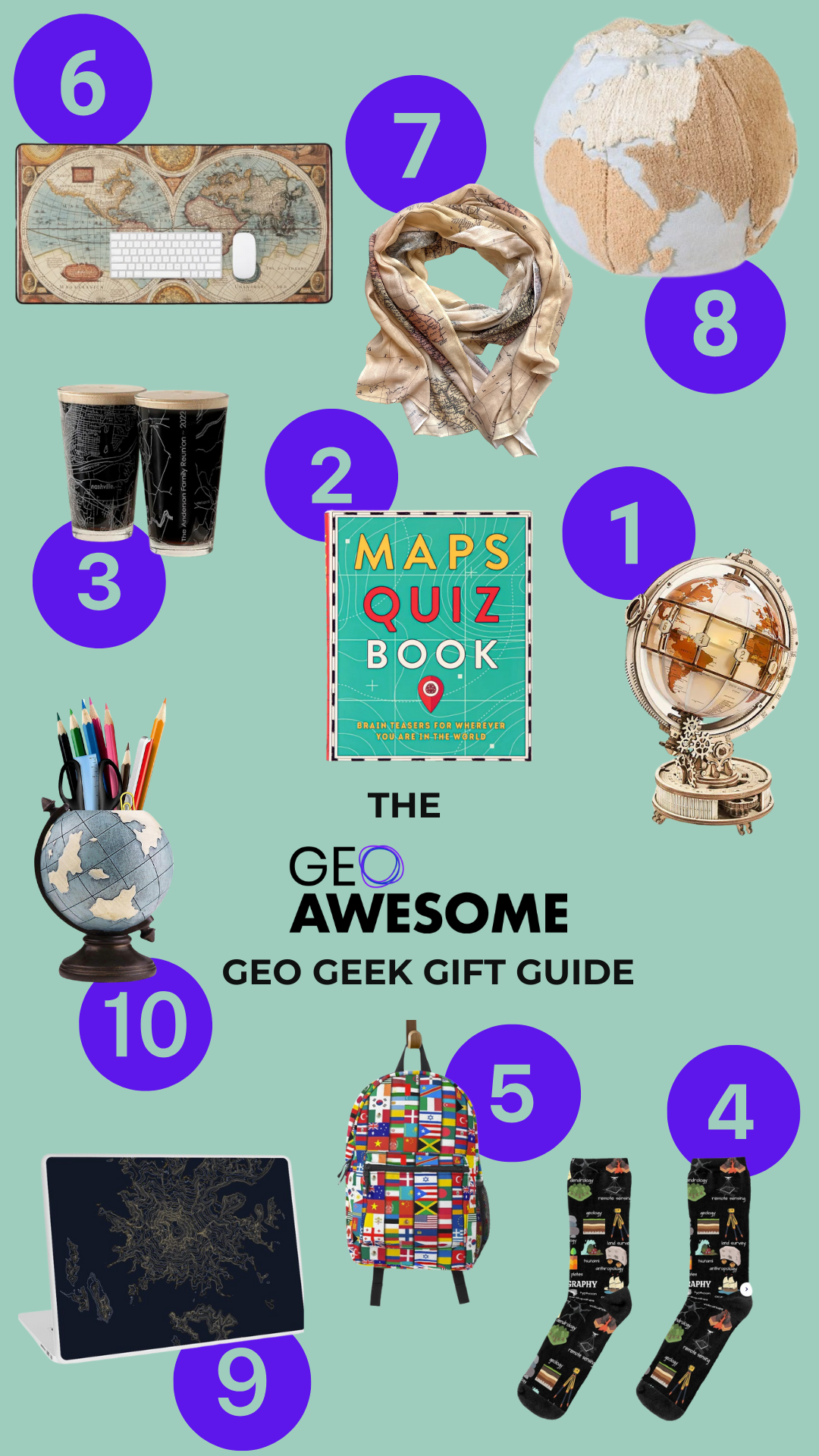
  • Maps Quiz Book$14,50 – Test your geography knowledge with this engaging and brain-teasing quiz book.
  • Geography Mindmap Socks $16,00 – $19,00 – Cozy socks with clever geography-themed designs for map enthusiasts.
  • Vintage Map Scarf $56,50 – A soft and elegant scarf featuring classic map prints for a touch of travel-inspired fashion.
  • Pufa World Map $224,00 – A stunning and detailed wall art piece of the world map for home or office.
  • GIS Word Art Laptop Skin $25,50 – $33,00 – Protect and personalize your laptop with this creative GIS-themed word art skin.
  • Globe Pen Pencil Holder $39,00 – A functional and artistic globe-shaped holder to organize your desk in style.

 Wrap Up Your Holiday Shopping

Make this Christmas special with gifts that inspire, celebrate, and encourage. These geo-themed treasures will make the festive season brighter.

Subscribe to our monthly newsletter for more geospatial stories, tips, and inspiration. Stay connected, inspired, and happy holidays!


Did you like this article? Read more and subscribe to our monthly newsletter!

Say thanks for this article (3)
The community is supported by:
Become a sponsor
#Fun
#Contributing Writers #Environment #Fun #Satellites #Science
Super-Resolution for Satellite Imagery Explained
Sebastian Walczak & Nikita Marwaha Kraetzig 07.18.2024
AWESOME 2
#Environment #Fun #Satellites #Science
Exploring the World of Google Earth Engine Through Time-Series Visualizations
Sebastian Walczak 06.5.2024
AWESOME 2
#Contributing Writers #Featured #Fun #Ideas #People
Share Your Insights: Geoawesome is Looking for Contributing Writers
Nikita Marwaha Kraetzig 01.18.2024
AWESOME 5
Next article
The New Standard in EO - STAC: The Application of STAC API Browser
#Contributing Writers #GeoDev #Ideas #News #Science

The New Standard in EO – STAC: The Application of STAC API Browser

Have you ever attempted to analyze land cover for urban development or environmental change using EO data and found the process to be particularly time-consuming due to the difficulty in identifying the optimal dataset? Remote sensing offers plenty of datasets. Remote sensing offers an extensive and ever-growing collection of datasets, with estimates suggesting there are over thousands of unique datasets available globally. The Global Earth Observation System of Systems (GEOSS) alone aggregates data from over 150 providers, while platforms like Copernicus and Landsat collectively deliver petabytes of open-access data.

However, the process of obtaining and processing this data should be normalized and simplified to ensure broader accessibility and usability, enabling users to focus on deriving insights rather than overcoming technical barriers. The Spatio-Temporal Asset Catalog has the potential to facilitate more expedient work processes.

What is STAC?

The SpatioTemporal Asset Catalog (STAC) is a standard way to access geospatial data. STAC makes it easier for GIS professionals and remote sensing experts to find, share, and analyze satellite imagery, aerial data, and other spatial assets.

STAC creates a common way to organize data about locations. It has a hierarchical structure.

  1. Catalogs: Organize datasets and provide navigational context.
  2. Collections: Group related assets, such as imagery from a satellite over a specific time.
  3. Items: Contain metadata and links to specific data files, like GeoTIFFs or cloud-optimized GeoTIFFs (COGs).

Why is STAC Important?

STAC’s JSON format is compatible with modern web tools and APIs, making it essential for cloud-based geospatial workflows. It lets GIS practitioners focus on analysis, not data preparation.

The Plugin for QGIS

A key example of STAC’s practical utility is the QGIS STAC Browser plugin, which brings the power of STAC to desktop GIS software. This plugin enables users to:

  • Connect to STAC endpoints, including public repositories like AWS Open Data or private catalogs.
  • Search for data using spatial, temporal, and attribute filters.
  • Preview and download assets directly into QGIS for further analysis.

Use Case: Remote Sensing Workflow with STAC and QGIS

Imagine a researcher analyzing urban area using satellite imagery. Traditionally, finding relevant datasets across multiple sources is tedious. With STAC and the QGIS plugin:

1. The researcher connects to a STAC API providing Senitnel imagery, land cover, satellite imagery or DEM data (e.g. for Microsoft Planetary Computer STAC API it’s 124 collections in total!).

2. It’s possible to apply temporal filters to retrieve imagery for a specific period.

3. Scenes can be selected by additional filters, like cloud_coverage for satellite optical imagery, using CQL2_JSON language, e.g.:

{

“op”: “<=”,

“args”: [

{

“property”: “eo:cloud_cover”

},

20

]

}

4. Each dataset has metadata and additional links for resources.

5. Relevant scenes are previewed and loaded into QGIS as COGs, ready for immediate analysis.

Discover instructions of use and installation in this tutorial by Samweli Mwakisambwe, QGIS Core developer.

Here we showcase the exemplary usage of the STAC API by selecting two case studies: detecting urban land use change in Lagos, Nigeria, and assessing mangrove forest loss in Myanmar. Using ESA WorldCover datasets from 2020 and 2021, the STAC API integration in QGIS enables seamless data access and analysis for these diverse contexts. This approach highlights urban expansion in rapidly growing cities and ecosystem degradation in critical mangrove regions, offering insights into land use dynamics. The case studies demonstrate how geospatial tools can support urban planning and environmental conservation efforts. This methodology underscores the potential of STAC-enabled workflows for monitoring land cover changes globally.

This streamlined approach reduces the time spent on data discovery and enhances productivity.

The Future Perspectives

As more geospatial data providers adopt STAC, it is becoming a cornerstone of modern GIS workflows. By fostering interoperability and accessibility, it is paving the way for a more connected and efficient geospatial ecosystem.

For more information, visit stacspec.org.

Our inspiration for this story: Spatial Thoughts

Do you have any comments on the use of STAC? Have you used it? Share your thoughts!


Did you like this article? Read more and subscribe to our monthly newsletter!

Read on
Search