SPOT 6 Satellite successfully launched to the orbit, SPOT 7 on the way
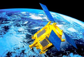
 High resolution (1.5 meters) SPOT 6 Earth observation satellite has been successfully launched to the orbit by a PSLV launcher from the Satish Dhawan Space Center in India., its twin SPOT 7 to join it within the first quarter of 2014.
SPOT 6 is an Earth observation satellite offering optical high-resolution capabilities, 1.5 m resolution having 60-km swath.
SPOT 6 and SPOT 7 are meant to ensure service continuity of SPOT 4 and SPOT 5 satellites, which have been operating since 1998 and 2002 respectively.
It is being operated by Astruim Satellite and exploited by Astruim Services in coordination with the two Pléiades satellites along the same orbit.
Both the ground and space segments have been designed for improved performances compared to previous SPOT missions, especially in term of reactivity -from satellite tasking to product delivery and collection capacity. The constellation SPOT 6 and SPOT 7 will actually provide a daily revisit everywhere on Earth with a total coverage of 6 million sq km per day. The satellites are designed to have a life span of 10 years.
Quoting Eric Beranger, CEO Astrium Services, ” With four satellites phased 90 degrees apart in the same heliosynchronous quasi-polar orbit, we will be able to offer our customers geo-information products in record time, in as little as six hours. With four satellites, we obviously have more freedom in terms of the revisit interval, for better change detection or faster coverage. Users can choose between very-high-resolution data capture at a specific point and high-resolution data capture over a larger area. We can also combine the two, of course. For instance, in case of flooding, SPOT 6 can provide the big picture and Pléiades will bring the focus over the most populated or damaged areas.”
To view the first images acquired by the satellite, follow this link.
And For more information click on the image below and watch the promo video.
Source: Spatial Source.com


