

 CartoDB is the next generation location intelligence and data visualization engine that enables the transformation of location data into insights. CartoDB is building an ecosystem that gives universally accessible technology to connect and map data, create data-driven customized visualizations, and develop location-based data applications.
Talking Maps and Open Source with Andrew Hill
CartoDB has been doing some great work lately, be it their Geoawesome Twitter visualizations of world cups, elections or some cool traffic flow maps. There are an interesting Geo startup that works with Open Source a lot, does a lot of community outreach and mapping. We had the pleasure of talking to Andrew Hill, their Chief Scientist Officer (Startup titles eh 😉 ) about maps, CartoDB and open source and where they are headed next. Read on 🙂
Open Source is at the heart of what CartoDB does, Was it the plan from day one?
Yes, it was CartoDB’s was created to bring location data intelligence to the masses by democratizing access to maps and location data and Open Source provides us the method to built the best software in order to reach our vision.
You had an interesting question “What are the limitations of what we call a map” in your interview to GeoHipster. Many companies have been pushing the envelope there, be it Twitter maps or visualization wearable tech data. What is your vision for maps?
We have built the optimal stack to create maps some of the time while leveraging geospatial capabilities all the time. This puts us in a good position to move and grow with the ever changing definition of the “map”.
Spatial sciences have benefited a lot from “outsider perspectives”. How would you define “Geospatial”? Moving forward do you think we are going to see greater integration with computer science and maps?
I’m 100% certain that the inflow of “geospatial” into computer science is well underway. Geospatial is just the dimension of data that defines location. In reality, so much of the data we are producing already is, or with a little bit of work could be, geospatial. Now more than every before, organizations and individuals are realizing the power and possibility hidden in the geospatial dimension of their data.
Now more than every before, organizations and individuals are realizing the power and possibility hidden in the geospatial dimension of their data.
Much of the work at CartoDB has been about rewriting maps & visualizations with JavaScript. How much is going to change now that WebAssembly is in the works?
Well, any advance on how the web works is going to have a great impact on the way we create and deliver visualizations. A faster web experience will mean a better product and also more possibilities. It is very exciting to see the web finally taking serious care of performance at this level.
Initiatives like Map Academy are going to definitely going to be a help when it comes to getting more people to appreciate the potential of location data. Are we going to see more courses at the Map Academy? How can the Open Source community can help with it?
Dig into some of the CS solutions to web mapping. Not necessarily learning how to code them, but learn how they have been solved. A lot of crazy interesting work has been done that doesn’t feel inherently “geo” on the surface but at the end of the day has changed maps possibly forever.
Learn how to code… at least a little.
You guys do some great work (and geoawesome visualizations) and attract some great talent. How do keep being so awesome?
Thanks for letting us in on the secret 🙂 What do you usual look for in people that you want to hire? A “Secret guide into the CartoDB mindset”, if you may 😉
A lot of times the problems we are trying to solve are at the edge of what defines our tool currently. So we are always drawing people from areas you wouldn’t necessarily expect. But yes, developing awesome things in open source catches our attention for sure! We also have a soft spot for people that have an eye for design in their work and people that engage the community in exciting ways.
Where do you see CartoDB in the next few years? Your vision for 2020!
We are moving fast in a few clear directions. In the first couple years of our existence, we focused on two things. First, building the easiest map editing tool on the web. And second, building a powerful geospatial backend that would solve an existing technical challenge for many businesses. Now we are moving fast to take both of those things to the next level. More client side, more data, more speed, more beauty. At the same time though, one of our biggest challenges is to educate the world on the power and value of geospatial data. We want to help them mobilize their own data to gain insights, make better decisions, and improve the things they are already doing.
We loved the twitter maps during the football world cup and the Indian elections. Do you think real-time twitter map feature is going to be available to the public soon?
Maybe, no plans right now, but we are always looking for ways to make our technology more accessible.
Madrid and New York, where are you headed next?
That’s a good question, but not one we can answer quite yet.
About Andrew Hill
 Andrew Hill is CartoDB’s Chief Science Officer, where he studies new methods for making maps in the CartoDB ecosystem. Andrew has his Ph.D. from the University of Colorado, Boulder, studying under Robert Guralnick. During his time at Boulder, Andrew led research on how automated data pipelines could be used to generate insights for biodiversity sciences. His work merged the natural sciences with data science and engineering.At CartoDB, Andrew leads a team of scientists, educators, and mappers that explore and develop new cartographic and GIS methods for CartoDB users. He has also been known to make far-out maps and instigate lively debates. Outside of CartoDB, Andrew is also an Assistant Professor, a board member of a citizen science non-profit, and an external advisor to a graduate program for mapping and cartography.


#Ideas


Next article
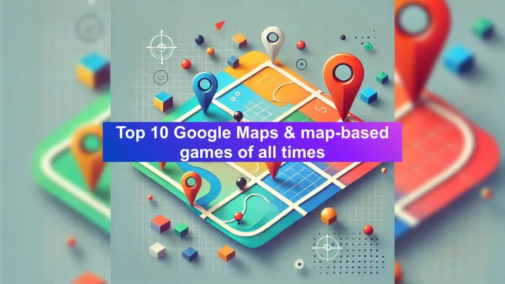

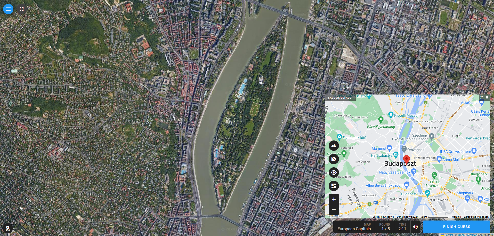
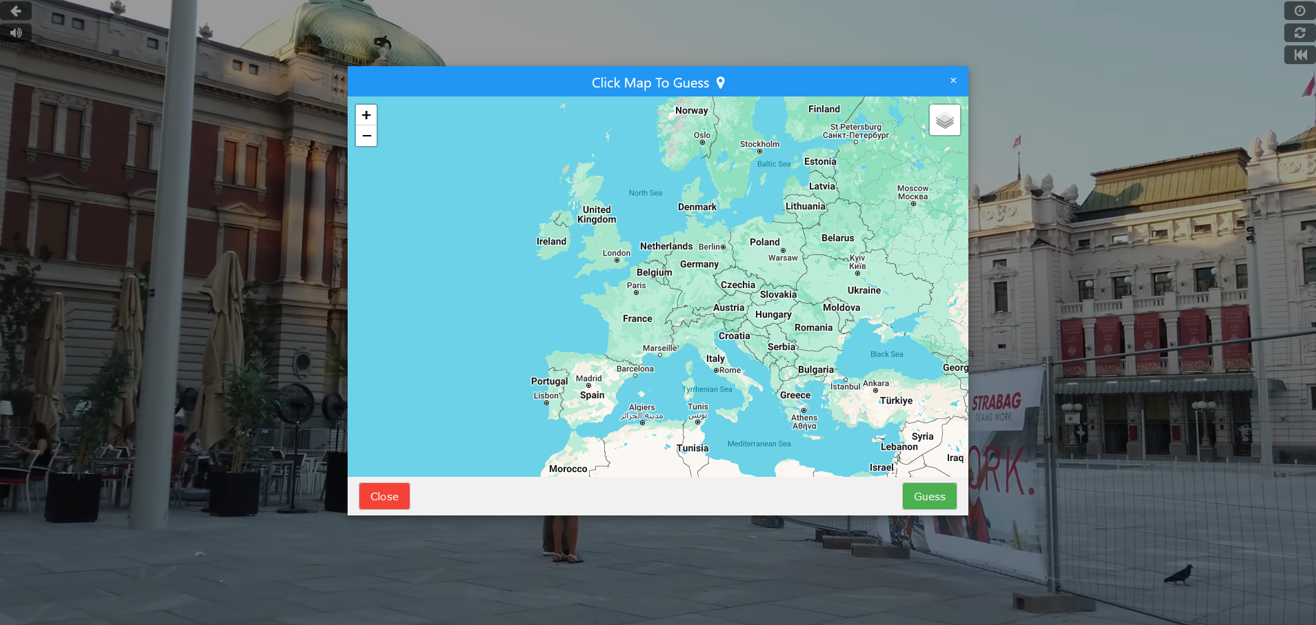
1. GeoGuessr
GeoGuessr is definitely on the top of our list of Top 10 Google Maps games. It started as a small web app that gives you the challenge of guessing the locations of a series of random Street View images. After you’ve made your guess, it reveals the real location, and awards points based on how close you get. It’s so addictive that it gained a lot of attention. On the website we can read that it partnered with brands like BBC, Skoda or The North Face.
[UPDATE] As original GeoGuessr is a paid app, here’s free alternative – OpenGuessr with identical feature as original one.
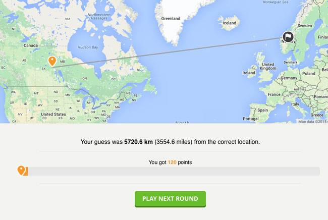
Google Maps games – GeoGuessr
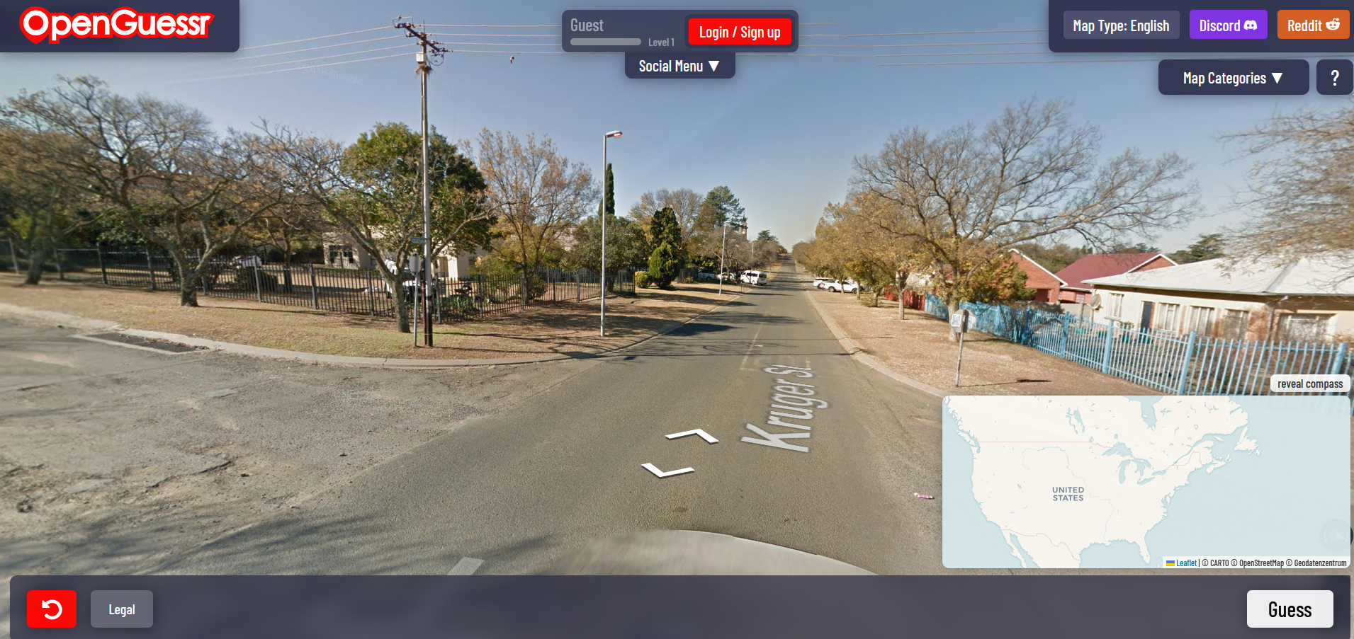
Open GeoGuessr
Also see: NASA has a video game to map coral reefs around the world
2. GeoPuzzle
GeoPuzzle is a geography-based game where players solve puzzles by arranging fragmented maps or geographic images to form a complete picture, honing their spatial reasoning and geographic knowledge in an interactive and entertaining way. With challenges ranging from identifying countries and landmarks to piecing together city layouts, GeoPuzzle offers an engaging experience suitable for players of all ages interested in exploring the world’s geography.
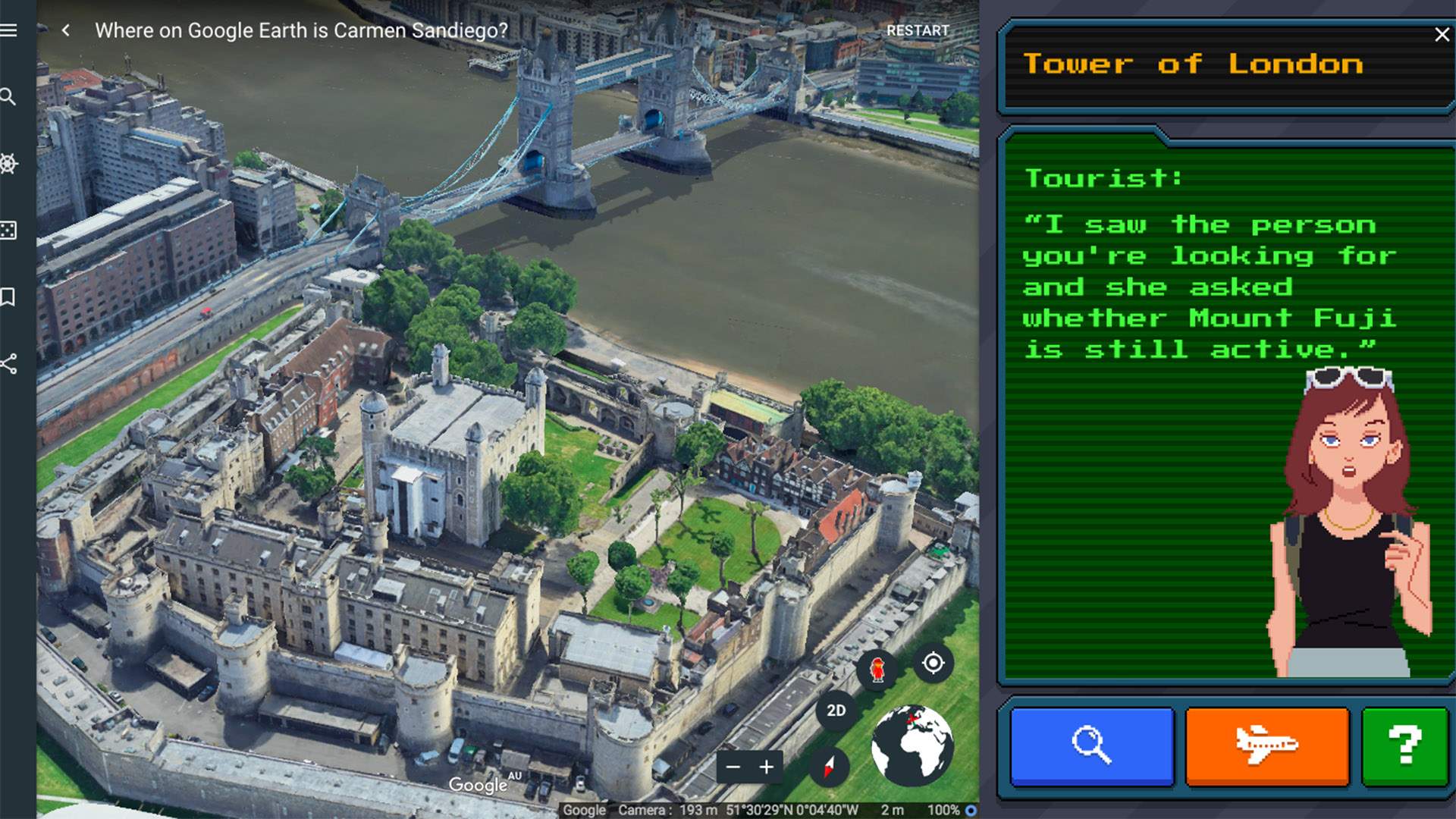
3. Where in the World is Carmen Sandiego?
Where in the World is Carmen Sandiego?: This classic educational game series, based on the popular franchise, incorporates Google Earth imagery in its modern iterations. Players must travel the world to track down the elusive Carmen Sandiego and her henchmen, solving clues and gathering
4. Geostatic
GeoStatic, the thrilling game that challenges your knowledge of global geography! Test your skills by identifying countries, landmarks, and natural wonders, all while racing against the clock. Unlock achievements, compete with friends on global leaderboards, and explore detailed maps with educational insights. Perfect for geography enthusiasts and casual gamers alike!
Suggested: What is contact tracing and why do Apple and Google want to do it?
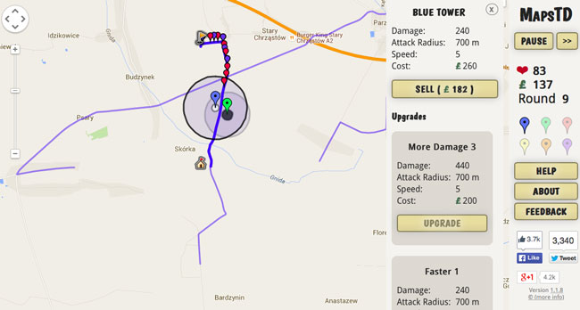
5. MapsTD
MapsTD is a tower defence game that uses Google Maps to generate levels from any location across the world. Your task is to defend your castle from attackers by strategically placing and managing your defense towers. It’s a pretty standard tower defence setup, but the pleasure comes from doing it across real-world streets and locations.
6. Google Maps Cube
Google Maps Cube is a game about Google Maps rather than based on Maps. It has been released as a promotion of G Maps after the launch of Google+ back in 2012. None the less it’s really worth mentioning. The game is about navigating a ball on a 3D Google Maps cube, avoiding the 3D buildings and other obstructions, by rotating the cube. You will play it only once, but you’ll have a lot of fun!
[UPDATE] Google Maps Cube is available to play with the Internet Archive: Wayback Machine
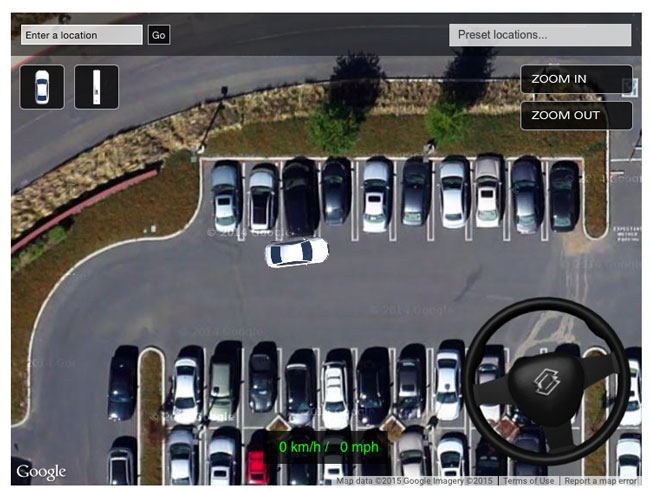
7. Driving Simulator
This 2D Driving Simulator is an experiment rather than an actual game. You can driver around the city with a car or a bus, the only problem is that it does not encounters any obstacles so in practice you can glide over everything on the map. Nonetheless I found it quite entertaining.
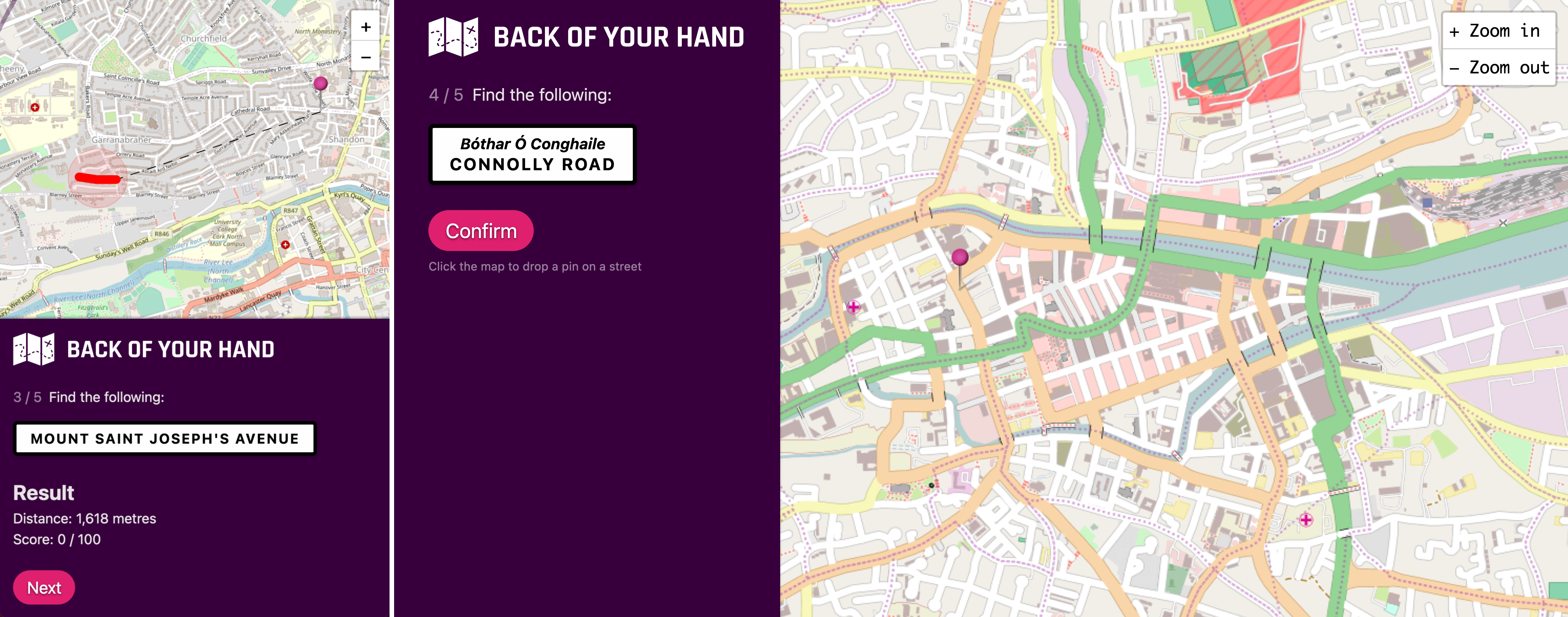
8. Back Of Your Hand
“Back Of Your Hand” is a map-based game that will test your geographical prowess like never before. Inspired by a familial fascination with local landmarks and street names, this game promises to challenge even the most seasoned cartographers. In this game, players are presented with random street names sourced from OpenStreetMap, spanning locations across the globe. Your task? Locate these streets on the interactive map within a time limit. Whether you’re navigating the labyrinthine alleys of Cork City or exploring the bustling streets of Tokyo, each round offers a fresh challenge. Test your skills solo or engage in friendly competition with friends and family using multiple devices. With each round, you’ll sharpen your spatial awareness and expand your knowledge of global geography.
9. City Guesser
City Guesser is one of maps games that strives to provide an exceptional travel and guessing experience. City Guesser launched on August 13th, 2020, and welcomes thousands of geography-enthusiasts each day.
10. StreetComplete
StreetComplete is more of a mapping tool than a game, but it gamifies the process of contributing to OpenStreetMap. Players are presented with simple quests to complete, such as confirming the existence of a certain feature or adding missing information to the map.
Did you like this post on Google Maps games? Read more and subscribe to our monthly newsletter!

