

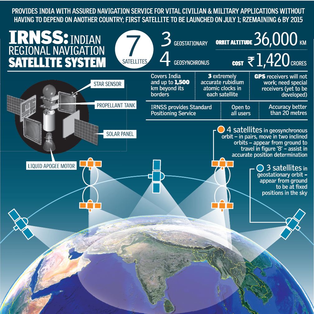
A decade ago, Scientists at the Indian Space Research Organization (ISRO) were starting to explore the possibility of having an Indian alternative to the GPS system, at least at a regional scale. A dream and a vision by the world’s largest democracy to have its own satellite navigation system is now taking shape in the form of ” The Indian Regional Navigation Satellite System (IRNSS) “
The first satellite of the 7 satellite constellation, IRNSS 1A has been launched successfully from Sathish Dawan Space Centre, Sriharikota. It was a perfect launch during the midnight of July 1st! IRNSS 1-A is officially India’s first dedicated Navigation Satellite! ISRO’s Polar Satellite Launch Vehicle, PSLV – 22 successful placed IRNSS 1-A in its orbit, the launch vehicle was previously used for launching Chandrayaan -1 (India’s Moon Mission).
IRNSS is only a regional navigation satellite and will in no way be a direct competitor to the Global Navigation Satellite Systems like GPS or GLONASS. India has already launched its own SBAS system in GAGAN (GPS Aided Geo Augmented Navigation) and the latest regional navigation satellite system is only going to help the GNSS Industry in the country grow. The design of IRNSS allows for an additional 3 satellites to be added to the original 7 satellites that are planned to be set into orbit by the end of 2015. However it would not be possible for the system to be converted into a Global system in the future. With launch failures of GLONASS satellites, it looks like GPS is set to be the standard for the time being, Beidou from China being the only realistic competition that can arise in the future with GALILEO struggling to move forward.
A picture says a thousand words and a documentary tells you the entire story.
If you are interested in having a closer look at the tech specs and other IRNSS information – here’s the link
For a country that became Independent during Midnight, it is rather fitting that its first major step in navigation satellite system should arrive on the midnight of July 1st!
Kudos ISRO! The Indian Regional Navigation Satellite System project is now underway!
Did you like this post? Read more and subscribe to our monthly newsletter!


#


Next article
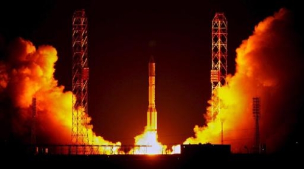


On Tuesday the Russian rocket has crashed seconds after launching from a spaceport in Baikonur, Kazakhstan. This accident creates a question about the future of Russian space program and it’s most known project GLONASS – Russian satellite navigation systems which is a competition to American GPS.
The unmanned Proton-M rocket fell 2.5 kilometers (1.6 miles) from the Baikonur launch site after an emergency shutdown of its engines 17 seconds into its flight. The explosion was so big that it created a 200m diameter crater followed by clouds of dangerous toxic gases.
But from Russian perspective it was more than just crush of the rocket… It was carrying worth $200 mln 3 navigation satellites to be used with Russia’s GLONASS positioning system. But this in not only about a money… even more about the reputation of Russian space industry, which competes not only with US but also with Chinese and European programs which are getting stronger every year.
This Monday one of GLONASS satellite got broken after just 4 years in space. Now 3 other satellites which where about to change the old are missing… The system requires 24 operating satellites with a few extra to increase the quality. Now Russian might be forced to limit the used of the system to its own boundaries.
In 2011 new iPhone had installed microprocessor which was for the first time able to operate not only with GPS but also with GLONASS… Now the reputation of the system will be severely challenged…
Did you like this post? Read more and subscribe to our monthly newsletter!