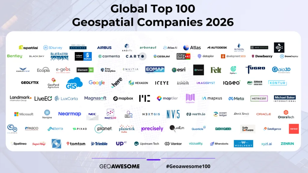

Discover the #Geoawesome100 organizations driving geospatial into the future. For the very first time, this year’s list was driven entirely by the global geospatial community, with nominations and votes cast by members around the world.
The wait is over
We’re thrilled to officially unveil the Global Top 100 Geospatial Companies 2026 — our annual recognition of the most innovative and influential organizations shaping the geospatial industry, marking Geoawesome’s 15th anniversary.
Traditionally, the Geoawesome Top 100 has been curated by panels of international experts representing academia, business, and research. Over the years, our expert panels have set a high standard, producing lists that have helped shape the global conversation about innovation and #geoawesomeness in our industry. For many companies, being part of the list has become both a badge of honor and a form of institutional recognition.
This year, we decided to do something different. For the 2026 edition, we handed the process entirely to the geospatial community, inviting professionals from across the world to help decide which organizations should be recognized. Over 125 professionals signed up to participate and share their inputs on which companies they believe are pushing boundaries, creating value, and moving the industry forward. It’s our first experiment in a purely community-led recognition process — and an important data point as we shape what comes next.
We take seriously the fact that this list is now seen as an authoritative signal of who is shaping the future of geospatial. We see that as both an honor and a responsibility. That is also why we are already planning a community + expert hybrid model for 2027, combining the breadth of community insight with the depth of expert review.
What the 2026 list represents
The Global Top 100 Geospatial Companies — 2026 Edition highlights organizations across the spectrum of our ecosystem: from established industry leaders to fast-growing scale-ups and specialists in areas like Foundation Models, EO analytics, 3D mapping, spatial digital twins, mobility intelligence, climate and sustainability solutions, and more. The list is not a ranking; companies are presented in alphabetical order.
As always, the goal is simple: to offer a trusted, independent reference point that helps practitioners, partners, investors, policymakers, and curious newcomers understand who is doing important work in geospatial right now — and to celebrate the people and teams behind that work.
#Geoawesome100 — 2026 Edition
Listed alphabetically — this is a recognition, not a ranking. Returning companies and new entrants for 2026 are marked next to each name.

























































































A simple list incase the logo wall doesn’t render for whatever reason 🙂
- 1Spatial — Returning
- 3Dsurvey — New for 2026
- AfriGIS — New for 2026
- Airbus Defence and Space — Returning
- Anditi — New for 2026
- Arbonaut — Returning
- Atlas AI — New for 2026
- Atlas.co — New for 2026
- Autodesk — Returning
- Avineon — New for 2026
- Axis Spatial — New for 2026
- Bee Maps — Returning
- Bentley — Returning
- BlackSky — Returning
- Blue Raster — Returning
- Caliper — New for 2026
- Carmenta Geospatial Technologies — Returning
- CARTO — Returning
- Cesium — Returning
- CityData AI — Returning
- dataplor — Returning
- Development Seed — Returning
- Dewberry — New for 2026
- DroneDeploy — Returning
- e-geos — Returning
- Eagleview Technologies — New for 2026
- Ecopia AI — Returning
- Element 84 — New for 2026
- Emu Analytics — Returning
- Envitia — Returning
- EOMAP — Returning
- ESRI — Returning
- Factori Technologies — New for 2026
- Felt — Returning
- FlyPix AI — Returning
- Fugro — Returning
- Gaia3D, Inc. — New for 2026
- Geolytix — Returning
- GeoPard Agriculture — Returning
- GIS Cloud — Returning
- Google — Returning
- HERE Technologies — Returning
- Hexagon — Returning
- ICEYE — Returning
- Iconem — Returning
- Imageryst — Returning
- IQGeo — Returning
- Kokusai Kogyo — New for 2026
- Kontur — New for 2026
- Landmark Information Group — Returning
- LiveEO — Returning
- LuxCarta — Returning
- Magnasoft — New for 2026
- Mapbox — Returning
- Mapcreator — Returning
- MapTiler — Returning
- Mapular — New for 2026
- Mapxus — Returning
- Meta — Returning
- METRICSAT — New for 2026
- Michael Baker International — New for 2026
- Microsoft — Returning
- Navigine — Returning
- Nearmap — Returning
- NEC Software Solutions (formerly Cadcorp) — Returning
- Next Geo — New for 2026
- NextBillion AI — Returning
- NextGIS — New for 2026
- North IO — Returning
- NV5 — New for 2026
- Ocean Ledger — Returning
- Onyx Space — New for 2026
- Oracle — Returning
- OroraTech — Returning
- Oslandia — New for 2026
- PASCO CORPORATION — Returning
- Picterra — Returning
- Pix4D — Returning
- Planet — Returning
- Planetek Italia — Returning
- Precisely — Returning
- Quantum — New for 2026
- Quarticle GmbH — New for 2026
- Regrid — Returning
- Safe Software — Returning
- Satelligence — Returning
- Sensat — New for 2026
- Spatineo — New for 2026
- SuperMap Software — Returning
- SynMax — Returning
- TomTom — Returning
- Trimble — Returning
- UP42 — Returning
- Upstream Tech — New for 2026
- Vantor (formerly Maxar) — Returning
- Vizzuality — Returning
- Wherobots — New for 2026
- Woolpert — Returning
- xyzt — Returning
- ZENRIN — New for 2026
Looking ahead: the 2027 hybrid model
With the 2026 edition, we experimented with a fully community-led process. In 2027, we are moving to a hybrid model that combines community insight with structured expert review.
Here is what that journey will look like:
- The 2027 Global Top 100 Geospatial Companies list will be published on Monday, 1 February 2027, returning to our tradition of releasing the list in late January or early February.
- Nominations for the 2027 list will open on Monday, 14 September 2026, to coincide with and pay homage to INTERGEO 2026 in Munich, which starts on Tuesday, 15 September 2026.
- Nominations will close on Friday, 27 November 2026.
- The wider Geoawesome community and newsletter subscribers will be invited to share their inputs through our November and December 2026 newsletters, helping us shape a strong, diverse shortlist.
- Our expert panel will vote on that shortlist between 14 December 2026 and 15 January 2027, bringing academic, industry, and research perspectives back into the process.
- Companies will be informed about the status of their nominations under embargo on Monday, 25 January 2027, ahead of the public announcement on 1 February.
With this, we aim to preserve what has always made the Geoawesome Top 100 valuable — a thoughtful, independent view of the industry — while opening more doors for community voices to be heard.
Frequently asked questions
Is this list ranked? No. The Global Top 100 Geospatial Companies list is not a ranking. All companies are listed in alphabetical order to avoid implying any hierarchy among them.
How was the 2026 list created? For the 2026 edition, we ran an open community process where geospatial professionals from around the world could sign up to participate. Over 125 community members contributed their inputs, helping us identify the organizations they see as most influential, innovative, and impactful today. The Geoawesome team then consolidated these votes and assembled the final list.
How is this year different from previous editions? In previous years, the list was curated exclusively by expert panels convened by Geoawesome. Those panels brought together leaders from academia, industry, and research to evaluate candidates against a consistent set of criteria. In 2026, for the first time, we shifted to a purely community-led approach, inviting professionals across the ecosystem to directly shape the final list. This year is an experiment in opening up the process, testing how community insight can complement the strong expert tradition that has defined the list so far.
What happens in 2027 – will experts still be involved? Yes. In 2027 we will move to a community + expert hybrid model. The community will help surface candidates and shape the shortlist, while an expert panel will review that shortlist and cast final votes. The aim is to combine the inclusiveness and breadth of community perspective with the rigor and continuity of expert evaluation.
What does being on the list mean for a company? Being included in the Geoawesome Global Top 100 is an acknowledgment that a company is playing a meaningful role in the global geospatial ecosystem — through its technology, products, services, research, or community impact. Over the years, the list has become an institutional reference for innovation and leadership in our space, and we are grateful that the community continues to treat it that way.
How can companies improve their chances of being featured in future editions? There is no single formula, but the companies that appear most consistently tend to combine technological excellence with clear, real-world impact. They contribute to open standards and interoperability, invest in their communities, and help make geospatial more accessible, useful, and trusted. Staying active in the broader Geoawesome community and engaging with calls for input and nominations will also matter more as we move towards the hybrid model for 2027.
Join us in celebrating the 2026 #Geoawesome100
To everyone who participated in the 2026 community process: thank you. This edition would not exist without your time, insight, and passion for geospatial. To the 100 companies on this year’s list: congratulations, and thank you for pushing our industry forward.
If you discover a new favorite company today, or if you see a familiar name you are proud to work with or support, take a moment to share the list, tag the teams behind the work, and celebrate them. Use #Geoawesome100 to help amplify the winners and spread the word about the innovation, collaboration, and creativity that make this community special.




#Featured


Next article

Geospatial Technology at a Legal Crossroads
How June 2026’s regulatory earthquakes are reshaping Europe’s geospatial landscape
Who should read this: This article is meant for professionals operating at the intersection of geospatial technology, legal compliance, and IT strategy; particularly those working within or doing business with the European Union. It is specifically tailored for GIS leaders and technical architects making long-term cloud infrastructure decisions, EU public sector CIOs and procurement teams preparing for emerging sovereignty mandates like CADA, Data Protection Officers (DPOs) assessing the legal risks of EU–U.S. cross-border data transfers, and commercial software vendors; both U.S. cloud providers and EU open-source developers looking to navigate shifting European procurement requirements.
It’s not every day that our sector is concerned about legal issues and what that could mean for the industry. But this is one of those rare occasions that is poised to change things.
Here’s the thing: June 2026 wasn’t just another month. It was a month when the tectonic plates of geospatial technology in Europe shifted significantly. The details are hidden in U.S. Supreme Court judgments, European Commission proposals, and earlier Court of Justice of the European Union (CJEU) jurisprudence—and what is unfolding now will have repercussions for years to come.
But here’s the truth: we’re still figuring out exactly how.
So let’s break this down together. What we know for sure. What we don’t yet. And what we can reasonably infer at this stage.
📋 What We Know
1. The Independence Question: FTC Oversight Under the Spotlight
June 29, 2026 On June 29, 2026, the U.S. Supreme Court issued a 6-3 decision in Trump v. Slaughter (No. 25-332), explicitly overturning the 91-year-old precedent Humphrey’s Executor v. United States (1935).
The Court ruled that “for-cause” removal protections for Federal Trade Commission (FTC) Commissioners are unconstitutional, declaring that because the FTC exercises executive power, its commissioners must be removable by the President at will.
In simple terms: The FTC’s structural independence from the White House has been removed.
Why this matters for geospatial:
The EU-U.S. Data Privacy Framework (DPF) relies on the FTC as a primary administrative enforcement mechanism to police U.S. corporate compliance with GDPR-equivalent protections.
Under GDPR Article 52 and Article 8(3) of the EU Charter of Fundamental Rights, third-country data protections require independent oversight. With FTC Commissioners now removable at will by the Executive, privacy advocacy groups argue that this independence requirement is structurally compromised, exposing the DPF to fresh legal challenges.
2. The Sovereignty Directive: Europe’s Proposed Tech Sovereignty Package
June 3, 2026 On June 3, 2026, the European Commission unveiled its proposed European Technological Sovereignty Package, a comprehensive set of legislative initiatives designed to address Europe’s technological dependencies on non-European suppliers.
At its core is the proposed Cloud and AI Development Act (CADA), which outlines a framework for public procurement built around four proposed assurance levels:
- Level 1: Basic cybersecurity (ISO 27001 equivalent)
- Level 2: Enhanced encryption + independence from third countries + transparency over software supply chain
- Level 3: EU ownership and control + additional criteria such as personnel citizenship requirements
- Level 4: Immunity from third-country control + highest level of European cybersecurity certification + components/products not subject to foreign jurisdiction
The critical point: If enacted in its proposed form, Levels 3 and 4, intended for defense, national security, and critical infrastructure would demand strict immunity from foreign jurisdiction and political interference.
3. The Open Source Push: From Preference to Policy Mandate
The EU Open Source Strategy (part of the same policy package) explicitly directs European public administrations to prioritise open-source software to mitigate proprietary foreign vendor lock-in.
Key objectives:
- Treating open source as a broader governance and industrial policy tool rather than just a software-development model
- Leveraging open source to strengthen tech sovereignty and build a vibrant European open-source ecosystem
- Promoting interoperable digital ecosystems and open standards for public administrations
The message: While proprietary software remains legal and widely used, software with high vendor lock-in faces increasing procurement headwinds in favor of sovereign, open-source alternatives.
4. Free Access to Standards: CJEU Ruling on Harmonised Standards
Building on momentum from the Court of Justice of the European Union’s (CJEU) landmark March 2024 decision in Case C-588/21 P (Public.Resource.Org), the rule that harmonised European standards must be freely accessible without paywalls continues to reshape technical compliance.
The CJEU confirmed that harmonised standards form an integral part of EU law, mandating their free accessibility and challenging traditional paywall models held by standards bodies.
Read: The end of paywall for standards
Why this matters: For geospatial, open standards are increasingly viewed as essential infrastructure. To align with Europe’s digital sovereignty roadmap, technical standards referenced in law must be freely accessible to developers and public bodies alike. Open standards must accompany open source in Europe’s sovereign technology ecosystem.
🤔 What Is Still Unknown
Here’s where the picture gets fuzzy and things are not yet 100% clear:
The DPF Legal Challenge Timeline
Privacy advocates (including noyb) are preparing CJEU challenges against the DPF based on executive oversight changes and surveillance laws. However, the DPF remains valid today.
Will it face:
- Gradual erosion through national Data Protection Authority (DPA) rulings?
- An eventual CJEU invalidation?
CADA Implementation Details
CADA is currently a legislative proposal. How will the European Parliament and Council modify the text during negotiations?
How will criteria be defined in final regulatory technical standards?
- “Foreign jurisdiction”
- “Personnel citizenship”
Harmonised Standards Scope
As the post-March 2024 legal framework continues to settle, how broadly will free accessibility apply across specialised geospatial standards referenced in European regulations?
Market Adaptation
How quickly will commercial geospatial vendors restructure (e.g., establishing fully autonomous EU subsidiaries) to comply with emerging procurement rules?
🔮 What We Can Reasonably Infer at This Stage
Based on these developments, here is where the trend leads:
-
1
Risk Management for Cross-Border Data Transfers
While the DPF remains legally active, the political changes surrounding FTC oversight mean EU organizations processing sensitive geospatial data on U.S. cloud platforms should proactively evaluate fallback data transfer mechanisms (such as Standard Contractual Clauses with supplementary measures) or local storage options.
-
2
Tighter Procurement for Critical Infrastructure
If CADA passes in a form close to its current draft, U.S.-domiciled cloud providers will face steep regulatory hurdles for high-security EU public sector tenders unless they offer fully isolated, EU-controlled sovereign cloud setups.
-
3
Growth in Open Source + Open Standards
The policy push toward open-source software and freely accessible standards will accelerate adoption across EU public administrations and research institutes.
-
4
A Multi-Cloud and Hybrid Architecture Shift
Organizations managing critical geospatial infrastructure will increasingly weigh hybrid setups—combining sovereign EU cloud options for sensitive core data with broader public cloud infrastructure for lower-risk operations.
💬 The Community’s Turn
While policy directions are clear, the real-world operational impacts are still being written.
📍 GIS Professionals in Europe
Is your organization discussing data sovereignty or reviewing cloud providers in response to these proposed rules?
💻 Developers & Vendors
How are you planning for potential procurement changes under CADA proposals?
⚖️ Legal & Policy Experts
What nuance should the geospatial community keep an eye on as these legislative texts move through the EU pipeline?
Let’s connect and keep the conversation going because how the geospatial sector adapts today will shape the ecosystem for years to come.
Geoawesome Analysis | June 2026 Regulatory Developments
A simple list incase the logo wall doesn’t render for whatever reason 🙂
- 1Spatial — Returning
- 3Dsurvey — New for 2026
- AfriGIS — New for 2026
- Airbus Defence and Space — Returning
- Anditi — New for 2026
- Arbonaut — Returning
- Atlas AI — New for 2026
- Atlas.co — New for 2026
- Autodesk — Returning
- Avineon — New for 2026
- Axis Spatial — New for 2026
- Bee Maps — Returning
- Bentley — Returning
- BlackSky — Returning
- Blue Raster — Returning
- Caliper — New for 2026
- Carmenta Geospatial Technologies — Returning
- CARTO — Returning
- Cesium — Returning
- CityData AI — Returning
- dataplor — Returning
- Development Seed — Returning
- Dewberry — New for 2026
- DroneDeploy — Returning
- e-geos — Returning
- Eagleview Technologies — New for 2026
- Ecopia AI — Returning
- Element 84 — New for 2026
- Emu Analytics — Returning
- Envitia — Returning
- EOMAP — Returning
- ESRI — Returning
- Factori Technologies — New for 2026
- Felt — Returning
- FlyPix AI — Returning
- Fugro — Returning
- Gaia3D, Inc. — New for 2026
- Geolytix — Returning
- GeoPard Agriculture — Returning
- GIS Cloud — Returning
- Google — Returning
- HERE Technologies — Returning
- Hexagon — Returning
- ICEYE — Returning
- Iconem — Returning
- Imageryst — Returning
- IQGeo — Returning
- Kokusai Kogyo — New for 2026
- Kontur — New for 2026
- Landmark Information Group — Returning
- LiveEO — Returning
- LuxCarta — Returning
- Magnasoft — New for 2026
- Mapbox — Returning
- Mapcreator — Returning
- MapTiler — Returning
- Mapular — New for 2026
- Mapxus — Returning
- Meta — Returning
- METRICSAT — New for 2026
- Michael Baker International — New for 2026
- Microsoft — Returning
- Navigine — Returning
- Nearmap — Returning
- NEC Software Solutions (formerly Cadcorp) — Returning
- Next Geo — New for 2026
- NextBillion AI — Returning
- NextGIS — New for 2026
- North IO — Returning
- NV5 — New for 2026
- Ocean Ledger — Returning
- Onyx Space — New for 2026
- Oracle — Returning
- OroraTech — Returning
- Oslandia — New for 2026
- PASCO CORPORATION — Returning
- Picterra — Returning
- Pix4D — Returning
- Planet — Returning
- Planetek Italia — Returning
- Precisely — Returning
- Quantum — New for 2026
- Quarticle GmbH — New for 2026
- Regrid — Returning
- Safe Software — Returning
- Satelligence — Returning
- Sensat — New for 2026
- Spatineo — New for 2026
- SuperMap Software — Returning
- SynMax — Returning
- TomTom — Returning
- Trimble — Returning
- UP42 — Returning
- Upstream Tech — New for 2026
- Vantor (formerly Maxar) — Returning
- Vizzuality — Returning
- Wherobots — New for 2026
- Woolpert — Returning
- xyzt — Returning
- ZENRIN — New for 2026
Looking ahead: the 2027 hybrid model
With the 2026 edition, we experimented with a fully community-led process. In 2027, we are moving to a hybrid model that combines community insight with structured expert review.
Here is what that journey will look like:
- The 2027 Global Top 100 Geospatial Companies list will be published on Monday, 1 February 2027, returning to our tradition of releasing the list in late January or early February.
- Nominations for the 2027 list will open on Monday, 14 September 2026, to coincide with and pay homage to INTERGEO 2026 in Munich, which starts on Tuesday, 15 September 2026.
- Nominations will close on Friday, 27 November 2026.
- The wider Geoawesome community and newsletter subscribers will be invited to share their inputs through our November and December 2026 newsletters, helping us shape a strong, diverse shortlist.
- Our expert panel will vote on that shortlist between 14 December 2026 and 15 January 2027, bringing academic, industry, and research perspectives back into the process.
- Companies will be informed about the status of their nominations under embargo on Monday, 25 January 2027, ahead of the public announcement on 1 February.
With this, we aim to preserve what has always made the Geoawesome Top 100 valuable — a thoughtful, independent view of the industry — while opening more doors for community voices to be heard.
Frequently asked questions
Is this list ranked? No. The Global Top 100 Geospatial Companies list is not a ranking. All companies are listed in alphabetical order to avoid implying any hierarchy among them.
How was the 2026 list created? For the 2026 edition, we ran an open community process where geospatial professionals from around the world could sign up to participate. Over 125 community members contributed their inputs, helping us identify the organizations they see as most influential, innovative, and impactful today. The Geoawesome team then consolidated these votes and assembled the final list.
How is this year different from previous editions? In previous years, the list was curated exclusively by expert panels convened by Geoawesome. Those panels brought together leaders from academia, industry, and research to evaluate candidates against a consistent set of criteria. In 2026, for the first time, we shifted to a purely community-led approach, inviting professionals across the ecosystem to directly shape the final list. This year is an experiment in opening up the process, testing how community insight can complement the strong expert tradition that has defined the list so far.
What happens in 2027 – will experts still be involved? Yes. In 2027 we will move to a community + expert hybrid model. The community will help surface candidates and shape the shortlist, while an expert panel will review that shortlist and cast final votes. The aim is to combine the inclusiveness and breadth of community perspective with the rigor and continuity of expert evaluation.
What does being on the list mean for a company? Being included in the Geoawesome Global Top 100 is an acknowledgment that a company is playing a meaningful role in the global geospatial ecosystem — through its technology, products, services, research, or community impact. Over the years, the list has become an institutional reference for innovation and leadership in our space, and we are grateful that the community continues to treat it that way.
How can companies improve their chances of being featured in future editions? There is no single formula, but the companies that appear most consistently tend to combine technological excellence with clear, real-world impact. They contribute to open standards and interoperability, invest in their communities, and help make geospatial more accessible, useful, and trusted. Staying active in the broader Geoawesome community and engaging with calls for input and nominations will also matter more as we move towards the hybrid model for 2027.
Join us in celebrating the 2026 #Geoawesome100
To everyone who participated in the 2026 community process: thank you. This edition would not exist without your time, insight, and passion for geospatial. To the 100 companies on this year’s list: congratulations, and thank you for pushing our industry forward.
If you discover a new favorite company today, or if you see a familiar name you are proud to work with or support, take a moment to share the list, tag the teams behind the work, and celebrate them. Use #Geoawesome100 to help amplify the winners and spread the word about the innovation, collaboration, and creativity that make this community special.


