Current Trends in Geospatial and Remote Sensing Research: A Review of Recent Scientific Literature
Editor’s note: This article was written as part of EO Hub – a journalistic collaboration between UP42 and Geoawesome. Created for policymakers, decision-makers, geospatial experts and enthusiasts alike, EO Hub is a key resource for anyone trying to understand how Earth observation is transforming our world. Read more about EO Hub here.
The EO Hub section of our site is dedicated to highlighting the key trends and use cases within the EO and geospatial sector. But, what if we looked beyond industry and shifted our focus to science? What are researchers coming together to investigate? What areas of interest are being funded, researched, and published across the world?
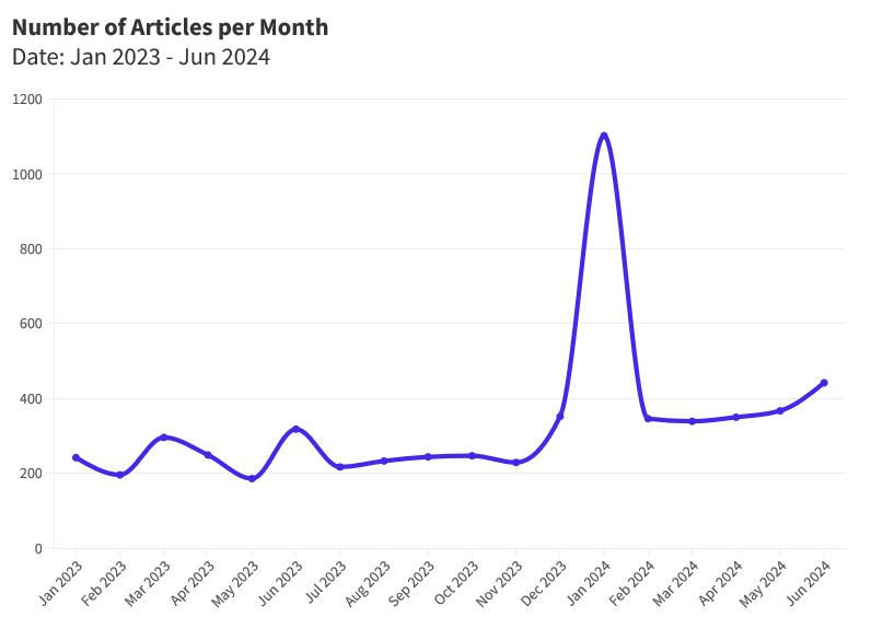
To find out we analyzed 6000 research articles published on the Springer Nature website from January 2023 to June 2024—revealing some intriguing insights.
We used Springer’s API and targeted keywords like “geospatial” and “remote sensing“. By doing so, we discovered key research topics, current trends, and themes, and took note of the countries with the most published articles on specific topics.
So, what topics are researchers looking at? That’s where keywords come in.
Reviewing Research: Why are Keyword Trends So Telling?
Keywords are an excellent marker to describe trends in research areas. They tell us a lot about how the field is developing, inform business decisions, and detect changes in research priorities.
Our review aimed to find the most popular keywords and technologies featured in research paper titles and abstracts. We then visualized the locations of these papers per country on a world map.
At the forefront of this is Springer Nature, one of the leading international scientific publishers. Springer publishes over 200 articles each month focused on remote sensing and geospatial. From satellite imagery techniques to GIS applications and advanced data analysis methods, Springer is a useful resource for researchers, industry professionals, and curious minds alike.
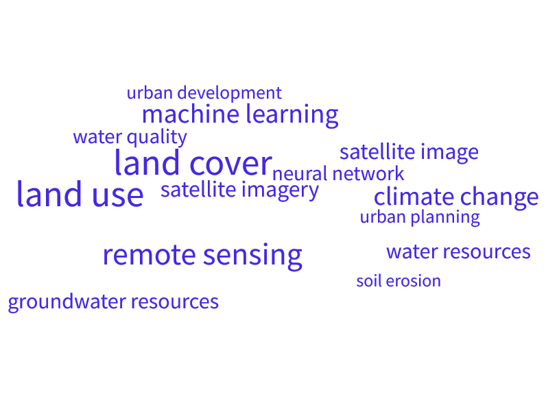
Keywords Shaping the Industry: A Snapshot of Geospatial and Remote Sensing Trends
Top Single Keywords:
The most popular keywords we found were:
-
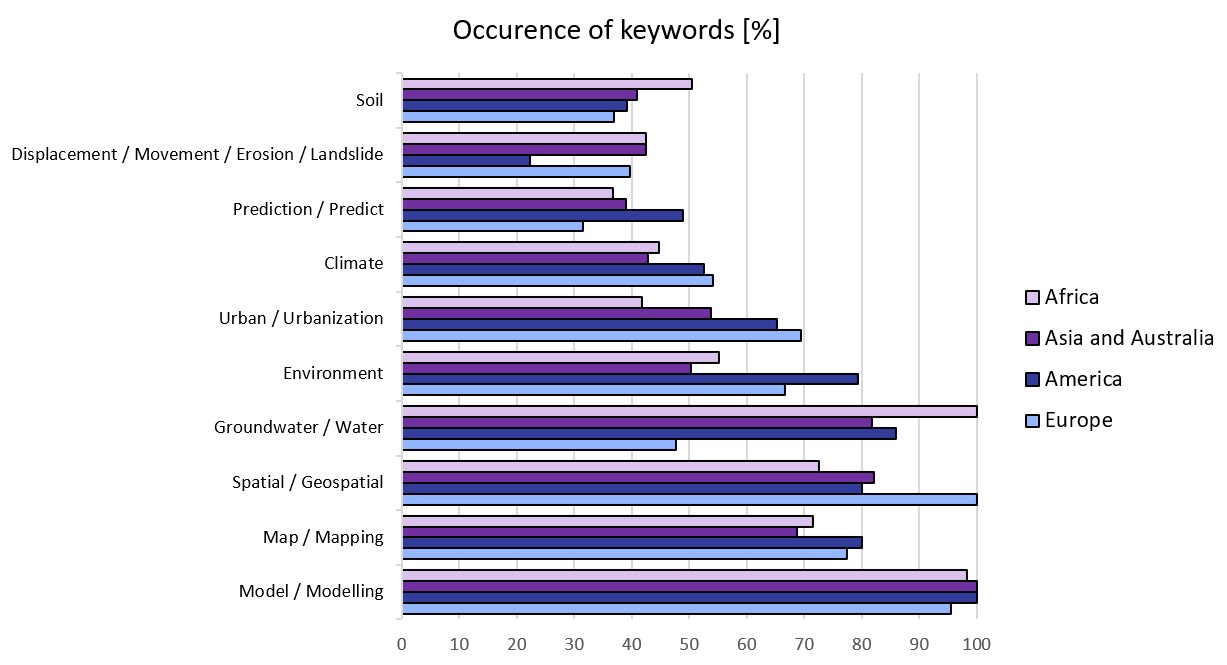
“Predict” and “Prediction”
In recent scientific papers, keywords like “predict” and “prediction” frequently appear in titles and abstracts, highlighting the growing importance of this topic in environmental research. Thanks to tools in remote sensing, earth observation, and geospatial technology, scientists can now accurately predict climate change, weather patterns, natural disasters, and land deformations. This tells us that researchers are heavily focused on future-proofing our world and preparing us for what is yet to come. From the collection of 6000 articles analyzed from the selected timeframe, 1230 were found to include these keywords.
-
“Groundwater” and “Water”
Keywords like “groundwater” and “water” are essential in studying the effects of groundwater pumping in mining areas and changes in water levels due to droughts or floods. For example, in African countries, where water scarcity is a significant concern, sustainable water management is essential to maintain groundwater resources and support communities. Understanding these factors is key to inventing effective strategies for water use and conservation. In our review, a total of 2004 articles featured the specified keywords.
-
“Urban” and “Urbanization”
Why do keywords like “urban” and “urbanization” frequently appear in research papers focused on geospatial and remote sensing? This is because of the growing interest in monitoring and managing city growth and its impacts. These terms often relate to the need for detailed analysis of urban areas (e.g. air quality or urban heat islands). Out of 6000 articles from the studied period, 1349 contained these keywords.
-
“Landslide”, “Erosion, “Soil”, Displacement”, “Movement”
Scientists frequently use keywords like “landslide”, “erosion”, “soil”, “displacement”, and “movement” to study the dynamics of the Earth’s surface and the factors contributing to land instability. These terms are essential for understanding natural hazards, soil degradation, and ground displacement, and critical for risk assessment or disaster management. 328 of the articles mentioned the keyword “landslide”, 361 talked about “erosion”, 1051 included the word “soil”, 63 used “displacement”, and 154 discussed “movement”. In total – almost 2000 mentions!
-
“Model” and “Modeling”
In the context of geospatial and remote sensing research, the keywords “model” and “modeling” are often used to describe the process of creating simulations and predictive tools that analyze spatial data and environmental changes. These terms are crucial for developing and testing hypotheses, and forecasting future conditions. An impressive number of 2931 mentions were detected in our research.
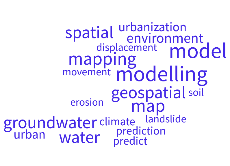
The top single keywords that occurred in the review of scientific literature
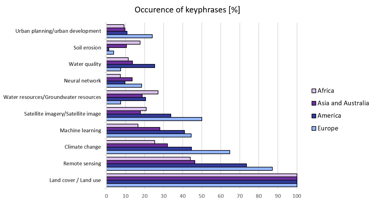
Top Keyword Phrases:
Now that we’ve taken a look at the single keywords currently trending, we wanted to cross-check this with keyword phrases that are shaping the research landscape. While individual keywords offer valuable insights into research trends, examining keyword phrases provides a more nuanced understanding of the current research landscape.
Our review points towards several dominant themes:
-
“Land Cover” and “Land Use”
The phrases “Land cover” and “Land use” appear as primary focus areas, underscoring the role of EO in mapping the Earth’s surface. Many articles address the topic of land use and land cover classification using EO, which supports development and enhances the accuracy of following GIS analyses. As many as 1925 articles contained these keyphrases.
-
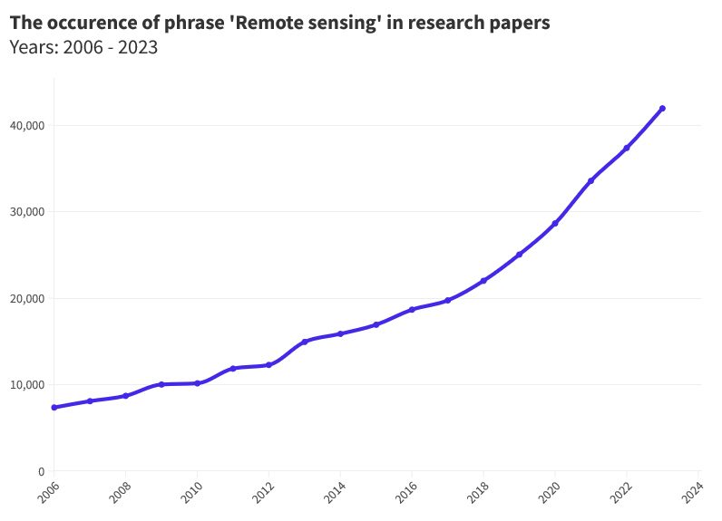
“Remote Sensing”
We found that “Remote sensing” remains a cornerstone phrase, reflecting the continuous evolution of sensor technologies. These advancements enable more accurate and detailed data collection, revolutionizing our ability to monitor and analyze Earth’s systems. If we look at the occurrence of this phrase over the years, there has been over a fivefold increase in frequency of use between 2006 and 2023. “Remote sensing” keyphrase occurred 1203 contained in revised articles.
-
“Climate Change”
The phrase “Climate change” dominates research papers due to its general impact on ecosystems and the need to address its effects. This popularity results from its influence on everything from weather patterns to human health, becoming an interdisciplinary study. This time 763 articles contained this keyphrase.
-
“Machine Learning” and “Neural Network”
The increasing frequency of phrases like “Machine learning” and “Neural network” highlights a growing trend toward AI-driven data analysis in recent years. Computational techniques, boosted by platforms such as UP42, improve the industry’s ability to handle and interpret BIG data. Among the 6,000 articles reviewed from the period in question, 745 contained the mentioned keyphrases.
-
“Water Resources”, “Groundwater Resources” and “Water Quality”
We noticed that keyword phrases such as “Water resources”, “Groundwater resources”, and “Water quality” have remained a high priority in recent years. Water resource management appears to be a significant topic from the perspective of scientists and the volume of research conducted on this subject. Of the 6000 articles examined from the specified period, 618 included these keyphrases.
The top keyword phrases that occurred in the review of scientific literature
Visualizing the Global Footprint of Geospatial Exploration
Now that we’ve explored the kinds of keywords being used in scientific literature, we wanted to know, where are the most scientific articles being produced?
We tried to answer this question by creating choropleth maps on the number of articles published by each country.
To craft these visuals, we were inspired by the Geoawesome article “How to Create Choropleth Map in Excel in Just 3 Minutes”.
Let us know if you’ve created similar maps from your own analysis, we’d love to see them!
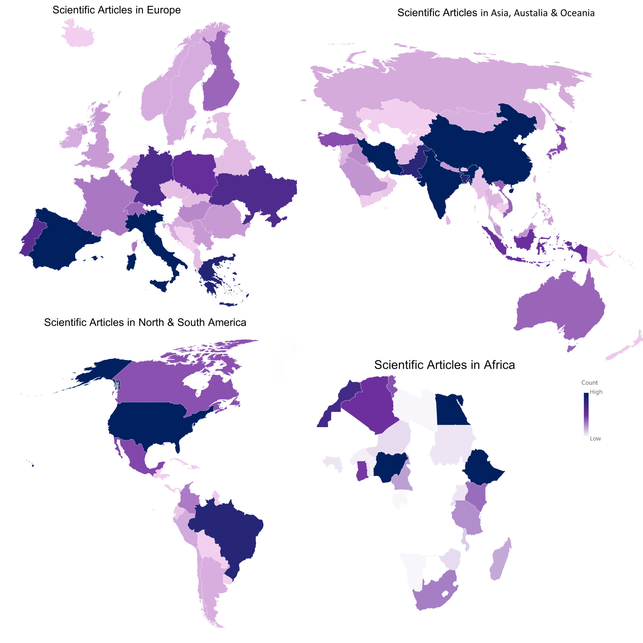
We created choropleth maps on the number of articles published by each country!
Regional Trends: What Do the Choropleth Maps Tell Us?
Research priorities in remote sensing and geospatial sciences demonstrate regional variations, reflecting each continent’s unique challenges, resources, and development trajectories.
For example, European and American countries invest heavily in research related to remote sensing using satellite imagery, artificial intelligence solutions, and climate change.
This continental diversity in research focus not only reflects regional priorities but also highlights the versatility and critical importance of remote sensing and geospatial sciences in addressing a wide array of global challenges.
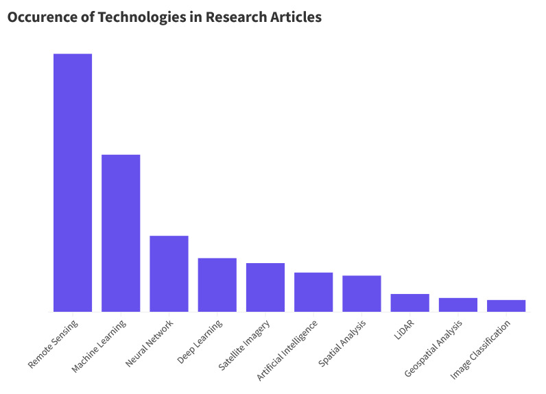
Analyzing Technological Trends
Next, we looked a little further and reviewed the occurrence of keywords related to technologies. From our analysis, it’s clear that remote sensing technology consists of various intermediate techniques, all unified by the common goal of observing and understanding our planet.
AI-based technologies, including machine learning and deep learning, are supporting various industries by improving data processing and interpretation. Remote sensing, integrated with AI, helps in interpreting geospatial data and expanding possibilities across diverse applications.
Geospatial Intelligence: Shaping a Sustainable Future
What did we find? Researchers are spending their time and energy looking into a clear cluster of topics in our ever-changing world.
Our analysis of 6,000 articles from Springer Nature shows that the geospatial and earth observation industry is focused on finding solutions for climate change, rapid urban development, and damaging land changes. It’s safe to say that from our research, researchers believe EO and AI hold the potential to address these major global challenges.
Now, more than ever, the focus is on the relationships between human activities, natural systems, and climate patterns. Our research underscores the geospatial and remote sensing industries’ role in creating a sustainable future, offering smart solutions to pressing global issues.
Are you researching some of the areas mentioned above? Get in touch to share your findings!
Did you like the article? Read more and subscribe to our monthly newsletter!

#Categories
Next article
Making Geospatial More Approachable Through Clear Documentation: Meet UP42’s Documentation Lead, Daria Lutchenko

Editor’s note: This article was written as part of EO Hub – a journalistic collaboration between UP42 and Geoawesome. Created for policymakers, decision-makers, geospatial experts and enthusiasts alike, EO Hub is a key resource for anyone trying to understand how Earth observation is transforming our world. Read more about EO Hub here.
The geospatial industry can seem overwhelming, filled with complex terms and concepts that can often intimidate beginners. Clear and concise documentation is essential for making geospatial technology more approachable. It simplifies complex concepts, allowing users to quickly understand and utilize geospatial tools and data without feeling overwhelmed.
Daria Lutchenko works on this every day. As UP42’s Documentation Lead, her main goal is to explain things clearly, so that “even a beginner feels empowered to explore this beautiful world of geospatial data and the opportunities it presents.” Her words, not ours!
We spoke to Daria to find out more about democratizing access to geospatial data and analytics at UP42, and the role that documentation plays:
Q: Thanks for joining us, Daria! Could you tell us more about your journey to becoming Documentation Lead at UP42? What inspired you to go down the technical writing path?
A: No one ever knows what technical writing is when I tell them I’m a technical writer. For me, it was something I stumbled into by chance. But when I learned more about technical writing, I realized it was something I’d been doing in my head my whole life—like thinking of better ways to structure a board game rulebook, or wondering why they crammed ten sentences into one paragraph instead of splitting or simplifying it. I’ve never had much patience for wading through overly complicated text, so I feel at home making ideas more accessible.
Q: We loved reading your article on the art of documentation in the geospatial industry. How do you believe clear, concise, and consistent documentation makes a difference in the lives of those who use geospatial data? What are the main barriers beginners face when getting started with geospatial technology?
A: Similar to the point I just raised, people have far more important things to do than wander through a jungle of words. Getting to the point as fast as possible can make all the difference in whether people choose your product. The geospatial industry is especially guilty of this because of the sheer complexity of the source material. There’s only so much you can simplify when it comes to satellite specifications, for example. But I still believe it’s our responsibility—those of us who want to attract new people to the industry—to break down that complexity, so that people can use it in their respective work fields.
Q: Why do you think it’s important that geospatial documentation is approachable? What are the potential benefits and real-world impacts?
A: When documentation is easy to navigate and understand, people can focus on solving real-world problems instead of grappling with complex concepts. Clear documentation empowers people to turn to geospatial data for the insights they need in their industries. If we don’t explain how it works first, the adoption itself might never happen. So making it understood is the first step in this process.
Q: How does UP42’s approach to documentation align with its mission of democratizing access to geospatial data and tools?
A: I think of our documentation principles as a continuation of the “democratizing access” approach. You can’t achieve democratization without inclusivity, and that, in part, starts with the documentation—with the terms you use and your approach. Whether you gatekeep, even unintentionally, or proactively try to be approachable and comprehensive in your communication style, it makes a difference. Ultimately, it’s about ensuring that those who want to learn more about geospatial, can do so, regardless of how technical or experienced in the industry they are.
Q: UP42’s mission aligns perfectly with the industry’s need for democratizing access to geospatial data and tools, especially as the field becomes increasingly important in addressing global challenges such as climate change and disaster management. Can you share an example of how UP42’s documentation has simplified a particularly challenging geospatial concept?
A: It was a challenge to explain the differences in processing levels because providers use their own terminology and naming conventions. And at UP42, being positioned between providers and customers, we needed to find a way to create a unified leveling system. We spent some time going through provider manuals and research papers, and discussing our ideas with experienced colleagues. In the end, we came up with a leveling system and introduced matrix tables on our collections’ pages to provide users with an understanding of the processing levels associated with each data product.
Q: How do you address the varying needs of different user groups (such as developers, analysts, and decision-makers) in your documentation? For example, how do you balance providing technical details with maintaining clarity for non-expert users?
A: It’s easy to do with UP42 products because we offer different access options, tailored for different audiences. The API and SDK are designed for developers, while our console—the graphical interface—is intended for decision-makers. The console provides an overview of our products and offerings but is also suited for ordering itself, for those users who don’t need to build ordering pipelines with developer tools. So by following this approach in our documentation, the separation of audience flows comes naturally: we have API and SDK references and tutorials for developers, and console instructions for those using the graphical interface.
Q: We know how important it is to adhere to global English principles so that documentation is accessible and comprehensible to a diverse audience—including non-native English speakers or those unfamiliar with the industry. Are there any other best practices you follow in your documentation to ensure approachability?
A: We’re user advocates above all, so I think the first step would be to adopt this mindset, and everything else will follow. We have a few formalized principles. For example, we don’t just describe what our products can do, but instead explain how they can benefit the reader. I’ve already mentioned the principle of being mindful of people’s time—we achieve this by getting to the important thing fast, starting with the key takeaway. Another principle, a favorite of mine, is “function over form”. Basically, this means that when you’re presented with a choice between something that looks better and something that’s more accurate text-wise, you should always go with the more accurate option. Meaning is always more important than design.
Q: How does UP42 gather feedback on its documentation and incorporate user suggestions for improvement?
A: We regularly meet with the Support team to go over their tickets and find areas for improvement. The idea is to provide answers in the documentation upfront, to reduce support requests. We all suffer from the “curse of knowledge”—when you know the product, it’s hard to imagine what will be unclear to readers—so exercises like this help with getting out of your comfort zone.
Did you like the article on Making Geospatial More Approachable Through Clear Documentation? Read more and subscribe to our monthly newsletter!

