Mobility is one of the most transformative forces in the 21st century, with the potential to radically change our lives and shape the future of our cities. The way we are going to get around our cities is changing with multi-modal transportation being touted as the way of the future. How can cities and other mobility service providers improve the transportation experience without having to worry about building an entire stack of APIs to take care of needs? We spoke to Stephen Smyth, the co-founder and CEO of Coord, to learn more about what it means to build a company that identifies itself as “developer platform for the mobility marketplace”. Read on!
Q: Stephen, let us get straight into it! When did you decide that you wanted to start your own company? And why did you decide to start a mobility company targeting the developers specifically? What’s your “unfair advantage”?
A: I have always been passionate about mobility – I actually began my career in transportation, developing virtual reality visualization and robotics simulation software for BMW in Munich. Subsequently, I worked in both product management and cross-functional leadership roles in digital media, education technology and, most recently, financial technology at lending marketplace Prosper in San Francisco. When the opportunity arose to co-found and lead Coord, it felt like a great combination of my experience in transportation, marketplaces and technology.
I view running a company in the same way that I view building a product. You are iterating and testing things, measuring your performance, and building trust with your market. As a CEO, I’m lucky to have the opportunity to do this not only with customers but also with my team.
We’re building the developer platform for mobility because we believe that developers will be the ones to create the connective tissue between the tech stacks of all the different players in the mobility space. That’s how you deliver a great trip experience in real-time. Our advantage is our team. We have come together from a lot of different backgrounds and experiences to focus on making seamless mobility available to everyone.
Q: Coord identifies itself as a “developer platform for the mobility marketplace”. Does that mean you that are building a full-stack API that developers can use to integrate mobility solutions i.e. getting from A to B (regardless of the transportation mode)? How does Coord differentiate itself from the routing APIs from Google, Mapbox, and others?
A: Yes, that’s exactly right! There are several great products that provide mapping services. We’re providing a layer of bookable mobility options – from curbs to bike-share – which sit on top of a map.
Q: One of the things that caught my attention about Coord was the Curbs API. I hardly realized how important curbs can be for a complete mobility solution before checking it out. In your blog post “building the curb map”, you mentioned that you use OSM and linear referencing to build this map. The blog makes it sound like it’s as easy as 1-2-3 but the engineering challenges must be quite remarkable. Could you tell us more about it? P.S: It is great to see that the data is now open, kudos for that.
A: The system for collecting and processing curb regulations is one of the most exciting and deep pieces of technology at our company. The steps include:
 Figuring out where the curbs are, as we describe in the blog post;
- Finding out what’s on the curb. This involves an app we call “Surveyor”, which lets data collectors use augmented-reality technology to locate different curb assets, like parking signs and fire hydrants, on the curb very accurately. We also ingest city-provided data: some cities already know where their parking signs are and what they say, and most cities know where their parking meters are and how much they charge. We ingest as much public, city-provided data as we can find.
- When we use the Surveyor app, we have to find out what the parking signs say. We have another blog post that discusses how we use computational biology to overcome some of the challenges around parking sign transcription!
- Understanding what the parking signs mean. This involves writing a parser that can read the text of parking signs and break them out into distinct regulations.
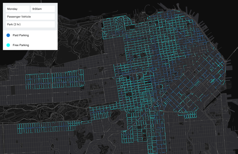
- Understanding how the different rules on the curb relate to each other. (If there’s a “no parking” sign on one side and a “2 hour parking” sign on the other, can you park or not?) We have a rule computation engine that takes in all of the curb asset data as well as the bylaws for each city and state that our API covers and produces the ultimate map of regulations.
Q: Coord’s Bike-sharing API doesn’t just provide a mobility solution for bike-sharing companies like Bikehunt but also takes care of transactions which is a fantastic idea (IMHO). Any plans for extending it to multi-modal transportation as well?
A: We want to support a next generation transportation system that spans across public and private providers. The bundling of these different types of mobility services will be crucial in the evolution of mobility.
Q: Could you tell us more about the tech stack at Coord? What technologies do you use? What programming languages do you guys use?
A: Our API backends are built in Go and run on Google Cloud Platform. Our database is PostgreSQL. One of the most helpful pieces of tech that we use every day is PostGIS — it makes working with geospatial data at production scale unbelievably easy and fun. We also love TypeScript and React for front-end coding.
Q: Coord’s business model revolves around developers using your API for building their apps and NOT selling ads. However, Mobility is an important area for location-based marketing and advertisement and in the era of numerous privacy-related controversies and GDPR – privacy remains a major concern. How do you handle the location data that the users share with you?
A: Most of our APIs don’t strictly require any user location data at all, since they are about infrastructure rather than users. However, we know that all location data has the potential to be sensitive. This is why we make sure that all of our APIs encrypt data both at rest and in motion. Our APIs also don’t allow customers to share user data with each other, so the Coord platform can’t be used to aggregate users’ location history or profiles.
Q: The Mobility market is on the rise today, with millions of euros being invested across the world and a ton of startups working on a wide range of products. Where do you see Coord in 3 years from now? What do you think are going to be your biggest challenges?
A: Three years from now, we want to be helping our demand and supply partners to connect in real-time to deliver millions of seamless trip experiences every month in hundreds of cities worldwide. We want to abstract away the complexity of current transportation systems and create a shared digital layer that enables the public and private sectors to work together to use transportation to make cities more livable.

Stephen and the coord team hailing a cab
Q: As a startup founder, I am sure that there are many things that you must have learned along the way. What was the most interesting feedback that you received so far?
A: Everyone knows that startups are inherently risky. But what you don’t hear as often is how to manage these risks. A seasoned entrepreneur once advised me that this means you should seek to reduce or eliminate risk in all areas of the company except for the one that is core to your idea. In other words if your innovation is a technology, think twice about also offering a new pricing model. Doing both at the same will likely increase adoption risk. If you were right about the appeal of the technical innovation you can come back and innovate pricing later.
Q: You are based in New York. How’s the mobility startup scene there? Are there any local meetups/events that cater to the geo-community? Are there any accelerator programs/venture capitals that focus on geo companies?
A: We love NYC! There’s a great geo meetup called GeoNYC that we’re hoping to speak at in August and another one called Transit Techies that we’re big fans of. Coord also offers developer workshops every two weeks at our offices to give developers time to come in and work on their projects with our support.
Q: Oh and before I forget, How’s life as an Alphabet company? 😉
A: We benefit a great deal from the access to the phenomenal people who work at other Alphabet companies and their partner companies in turn. Their feedback helps us to build a better product faster and get it in front of more developers at organizations big and small.
Q: Okay, this is a tricky one – on a scale of 1 to 10 (10 being the highest), how geoawesome do you feel today? 😉
A: So geoawesome! My team teases me that I don’t favor exclamation marks but in this case, I’ll make an exception.
Q: Any closing remarks for anyone looking to start their own geo-startup?
A: Get involved in the community! The geo community is vibrant in most major cities. The people that attend the meetups and conferences are open to new ideas and well versed in the existing players and ecosystem. They’ll provide you with a great initial sounding board and maybe even become part of your founding team.
If anyone would like to reach you, what would be the best way to do so?
Please email us at partners@coord.co
The Next Geo is supported by Geovation:
 Location is everywhere, and our mission is to expand its use in the UK’s innovation community. So we’re here to help you along your journey to success. Get on board and let’s start with your idea…
Learn more about Geovation and how they can help turn your idea into reality at geovation.uk
About The Next Geo
The Next Geo is all about discovering the people and companies that are changing the geospatial industry – unearthing their stories, discovering their products, understanding their business models and celebrating their success! You can read more about the series and the vision behind it here.
We know it takes a village, and so we are thrilled to have your feedback, suggestions, and any leads you think should be featured on The Next Geo! Share with us, and we’ll share it with the world! You can reach us at info@geoawesomeness.com or via social media 🙂
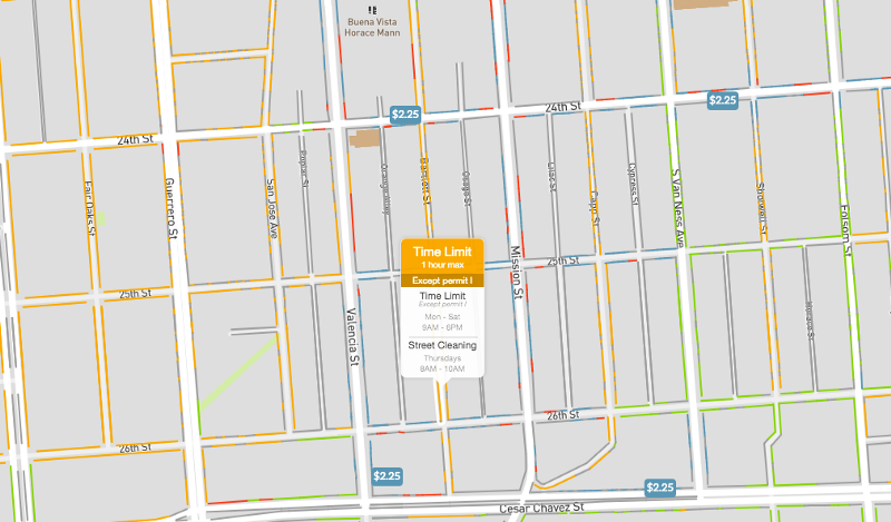

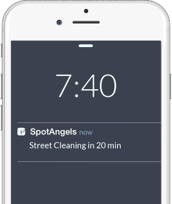 But then comes the part where this smart parking app truly shines. It sends out reminders to help you avoid parking tickets. For example, you will receive a prompt to remove your car before alternate side parking (street cleaning) begins or paid parking times out. Since its launch in 2015, the free app has saved users more than $2 million in parking tickets. So, while municipalities may not have a soft spot for SpotAngels because of all the money it is making them lose, the app’s fans in 25 cities in the United States and Europe sure love it!


