
[First published: July 14, 2017 by Vinithra Rajendran. Major 2026 rewrite: list rebuilt from the live catalogues at Mastersportal and FindAMasters.]
With most autumn-intake decisions landing around now, June is a perfect moment to weigh your options and settle on which university is right for you. By 2026 the geospatial-education landscape had grown well past the point where any single hand-curated list can stay accurate for long. There are now more than 300 active Master’s programmes in GIS alone — and that’s before counting the dedicated Remote Sensing, Earth Observation, Geomatics and Cartography degrees that overlap with the discipline. New programmes launch every academic year; old ones merge or shut down. A list maintained by one author cannot keep up.
For this 2026 edition we did something different. Rather than attempt yet another hand-curated catalogue, we point readers straight at Mastersportal and FindAMasters (the two largest international Master’s-degree aggregators, which actively verify programmes with universities and keep entries current). Below we have included 318 programmes spanning 39 countries — drawn from Mastersportal’s GIS catalogue plus FindAMasters’ GIS and Remote Sensing catalogues. This includes both the dedicated GIS, Remote Sensing, Geomatics & Cartography degrees and the borderline cross-disciplinary programmes that Mastersportal also lists under their GIS catalogue (Geological Sciences, Spatial Planning, Geotechnical Engineering with geospatial components, Quantity & Building Surveying, Geoarchaeology). The authoritative, complete, up-to-date list lives at the aggregator search pages, and that’s where we recommend you start.
Browse the full live catalogues:
- Mastersportal — Master’s in Geographical Information Systems (GIS) — 300+ programmes
- FindAMasters — Master’s in GIS — 50+ programmes
- FindAMasters — Master’s in Remote Sensing — 40 courses
What changed in 2026
The aggregator pages have three big advantages over any static list:
- They’re verified. Both Mastersportal and FindAMasters work directly with universities to keep programme pages, fees, deadlines and course descriptions current.
- They’re searchable and filterable. You can narrow by country, format (online / on-campus / blended), tuition, duration, and start date — the things that actually drive a decision.
- They include the metadata that matters. Tuition fee ranges, application deadlines, English-language test minimums, links to scholarships — all in one place.
What you’ll find below is a curated dataset drawn directly from those catalogues — not the full picture. Use it to get a sense of the categories, geographies and formats on offer, then go to the aggregator pages above to filter for what suits you.
How to read the categories
Programmes in this space sit on a spectrum across three core overlapping classes:
- GIS & Geoinformatics — Analysis-, software-, and application-oriented degrees. This track includes classic GIS coursework, geomatics, traditional surveying, geodesy, and cadastre. It is strongest for urban planning, environmental consultancy, public-sector GIS, infrastructure management, precise engineering positioning, and increasingly spatial data science.
- Remote Sensing & Earth Observation — Satellite, drone, and airborne data acquisition and processing, built on a stronger physics, signal processing, and image-analysis foundation. This track focuses heavily on satellite imagery, photogrammetry, radar/LiDAR technologies, and climate modeling. Career paths lead to EO companies, climate-tech roles, and major space agencies like ESA, NASA, EUMETSAT, DLR, and CNES.
- Mixed / Cross-Disciplinary — Overlapping or cross-functional tracks that blend geospatial technology with separate major fields. This class catches borderline cross-disciplinary master’s degrees (such as Geological Sciences, Spatial/Regional Planning, Geoarchaeology, and Geotechnical Engineering with geospatial components) as well as multi-site Erasmus Mundus joint degrees and dedicated online MGIS tracks that bridge multiple remote learning hubs.
The order in every table below is non-ranked. Best fit depends on what you want to do after graduation, not on any league table.
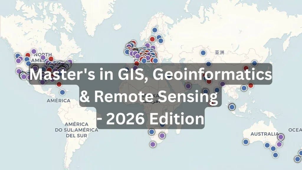
Interactive map
Programme missing or something wrong with the map? Get in touch and we’ll update the map. If you’re a university and want your programme to appear on the aggregator searches above, that’s a conversation with Studyportals or FindAMasters directly.
How to pick a programme
- Does the curriculum actually require programming? In 2026, “GIS without code” essentially means “operating ArcGIS Pro and QGIS as a power user”. That’s still a viable career, but for EO, GeoAI or spatial data science roles you need Python at minimum, with R, SQL/PostGIS, and ideally JavaScript on top. Check the syllabus on the Mastersportal page for explicit programming modules.
- Is there a GeoAI / machine-learning component? Foundation models for Earth observation (Prithvi, Clay, DOFA, SatlasPretrain) are advancing the field. Programmes that include deep learning for raster data, computer vision, or geospatial foundation models will date much better than those without.
- What’s the data and software stack? Esri-centric, open-source-centric, or both? Cloud platforms (Google Earth Engine, AWS Open Data, Microsoft Planetary Computer, Sentinel Hub, Copernicus Data Space Ecosystem)? Hands-on with Sentinel-1/2, Landsat, SAR? Check the programme description before applying.
- Tuition and funding. Mastersportal’s fee filter is genuinely useful here — the catalogue shows tuition in your selected currency, and flags scholarship availability. Programmes in continental Europe (Sweden, Germany, Czechia, Poland) routinely come in at €1,000–4,000/year, while UK and US tuition can be 10–30× that.
- Online or in-person? Online is excellent for working professionals upskilling, but if you’re switching careers into geospatial from scratch, on-campus still wins on lab access, peer learning and recruiter networking — especially for Europe-based EO roles where ESA, EUMETSAT, and major EO employers run on-site recruitment.
Honest caveats
Two caveats worth being explicit about:
First, the dataset above is not exhaustive. It draws from the top of Mastersportal’s worldwide GIS search and reflects the editor’s choice of what to highlight — there are 300+ GIS programmes on Mastersportal alone, plus more on FindAMasters and yet more that aren’t listed on either aggregator (particularly programmes outside the English-speaking world). If your country, language or specialism isn’t represented above, the aggregator searches are the right next step. The scatter map is also not 100% accurate — we did not have the exact coordinates of each faculty, so the points are indicative and meant only for a broad geographic overview.
Second, tuition, deadlines, and curricula change every year. Always verify on the official programme page linked from the Mastersportal entry before applying. The aggregator’s information is current at the time of indexing, but the university itself is the only authoritative source on a given intake’s tuition, deadline, and entry requirements.
Did you find this 2026 update of Master’s in GIS useful? Read more from the EO Hub and subscribe to our monthly newsletter to keep up with how the geospatial degree landscape keeps changing.

#Fun


Next article
For decades, the Earth Observation industry followed a simple rule: if you wanted better imagery, you launched better satellites.
Today, a growing number of companies are asking a different question: how much more value can be extracted from the data already in orbit?
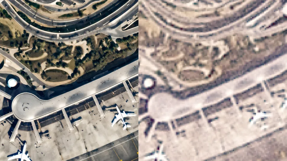
One of them is Stellaria, a UAE-based geospatial startup whose new AI model, Meruem, aims to enhance satellite imagery across optical, SAR, and hyperspectral sensors. Rather than building new satellite sensors, Stellaria is focused on improving the quality and usability of existing imagery through super-resolution technology.
The concept is attracting increasing attention across the industry. As satellite constellations generate more data than ever before, many organizations are discovering that access to imagery is no longer the main challenge. Extracting useful information from that imagery is.
From Agriculture to GeoAI
The story behind Stellaria starts long before the launch of Meruem.
The company’s roots can be traced back to Farmin, a startup founded by Ali AlHammadi in Abu Dhabi in 2019. Initially focused on agriculture, the company explored how satellite data could help farmers improve productivity, water management, and resource efficiency.
While working with satellite imagery, the team encountered a familiar challenge: the available data often lacked the level of detail required for operational decisions.
That challenge led them into AI-powered image enhancement.
What began as an agricultural use case gradually evolved into a broader geospatial intelligence platform serving sectors such as infrastructure, maritime operations, environmental monitoring, and security. Meruem appears to be the result of that journey—a product built on years of experimentation with super-resolution techniques.
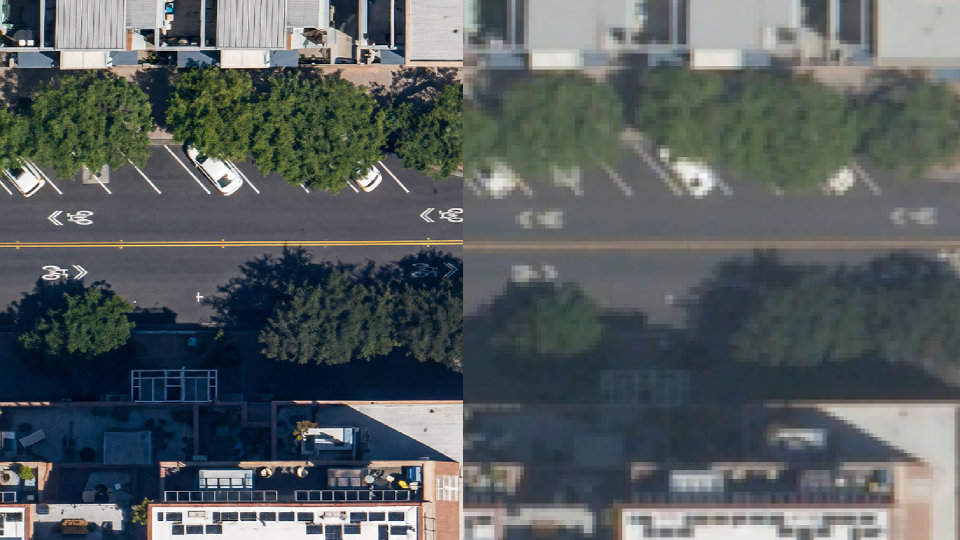
credit: Stellaria
Why Super-Resolution Matters
Earth Observation users often face a trade-off between cost and image quality. Higher-resolution imagery can be expensive, while lower-cost datasets may not provide enough detail for certain applications.
Super-resolution attempts to bridge that gap.
Using AI, these models analyze existing imagery and reconstruct additional detail, creating images that can support more accurate interpretation and analysis. The goal is not simply to create sharper pictures, but to improve the value of downstream workflows.
For mapping teams, that could mean better asset extraction and change detection. For agriculture, more precise field monitoring. For maritime operators, improved situational awareness. For disaster response teams, more useful imagery when higher-resolution data is unavailable.
The real question is not whether the imagery looks better, but whether users can make better decisions because of it.
A Growing Competitive Landscape
Stellaria is entering an increasingly crowded market.
Companies such as Maxar have already demonstrated demand for AI-enhanced imagery through products like HD imagery. Others, including Nara Space and LuxCarta, are developing their own super-resolution capabilities for mapping, GIS, and analytics applications.
What differentiates Stellaria is its ambition to position super-resolution as part of a broader geospatial intelligence platform rather than as a standalone image enhancement service. The company is also pursuing a multi-sensor approach, extending beyond optical imagery into SAR and hyperspectral data.
Whether that differentiation proves meaningful will depend on customer outcomes. Organizations are unlikely to pay for sharper images alone. They will pay if enhanced imagery improves analytics, reduces costs, or enables decisions that were previously impossible.
The Trust Challenge
Like every company working in this space, Stellaria faces a fundamental challenge: trust.
When AI adds detail to an image, users need confidence that the information reflects reality rather than assumptions made by the model.
This is particularly important in sectors such as defence, critical infrastructure, insurance, and government, where decisions can have significant operational or financial consequences.
The broader Earth Observation community is increasingly focused on issues such as transparency, auditability, provenance, and hallucinations. While Stellaria highlights quality-control mechanisms and safeguards within its processing pipeline, independent validation will ultimately matter more than company claims.
The challenge for all super-resolution providers is the same: users need confidence that AI is revealing information rather than inventing it.
A Sign of Where the Industry Is Heading
Regardless of how Meruem performs in the market, its launch reflects a broader trend within Earth Observation.
Some of the most interesting innovation is no longer coming solely from satellite operators. Increasingly, value is being created by companies building software layers on top of existing data sources.
The UAE has invested heavily in space, artificial intelligence, and geospatial technologies over the past decade. Companies like Stellaria represent a new generation of startups emerging from that ecosystem and bringing new ideas to the global market.
Meruem is one example of a much larger shift. Alongside efforts from Maxar, LuxCarta, Nara Space, and others, it reflects a growing belief that the future of Earth Observation will be shaped as much by software as by hardware.
The next phase for the industry is not about collecting more data. It is about making better use of the data we already have.

