
We rely on it daily – whether navigating to a new café, tracking a package, or mapping a field. But how does GPS work, and what exactly is GNSS? Let’s discover the invisible technology that powers modern life.
The Birth of GPS: A Cold War Invention
Although in everyday language, GPS is often used to describe any location-tracking device, in reality, it refers specifically to the American satellite navigation system. The Global Positioning System (GPS) was born out of military necessity during the Cold War. Developed by the U.S. Department of Defense, the system was designed to provide accurate positioning for strategic military operations.
- 1973: GPS concept approved by the DoD.
- 1978–1985: First satellites launched (Block I).
- 1995: Declared fully operational with 24 satellites.
Its design was inspired by earlier satellite navigation experiments like TRANSIT, and has since grown into a globally critical system. Today, it’s freely accessible for civilian use across the world.
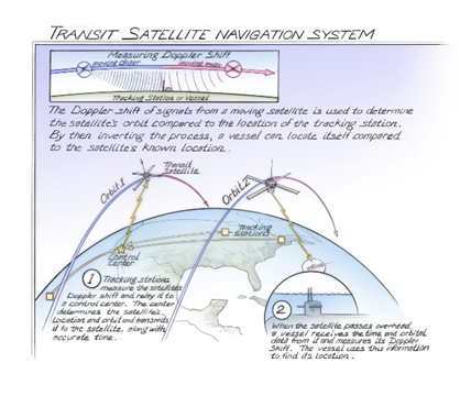
Transit Satellite Navigation System. Source
GNSS: A Constellation of Constellations
GNSS (Global Navigation Satellite Systems) refers to all satellite-based positioning and timing systems, including but not limited to GPS. These systems are the backbone of modern navigation, geospatial applications, and timing services.
Major Global Systems:
- GPS (USA): Operational since 1995, maintained by the U.S. Space Force.
- GLONASS (Russia): Developed in the 1980s; global coverage restored by 2011.
- Galileo (EU): Launched by the European Union; full services expected by 2027.
- BeiDou (China): Began as a regional network in 2000 and achieved full global coverage in 2020.
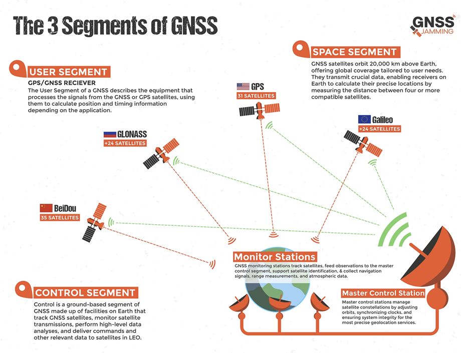
The Three Segments of Each GNSS:
- Space Segment: The satellites orbiting the Earth that broadcast positioning and timing signals.
- Control Segment: The network of ground stations that monitor, maintain, and update the satellites and their signals.
- User Segment: The receivers and devices (from smartphones to surveying instruments) that capture GNSS signals to calculate precise location and time.
Each GNSS operates independently but modern receivers can combine signals from multiple constellations (multi-GNSS) to improve accuracy, reliability, and redundancy for applications on land, sea, air, and even in space.
How GNSS Positioning Works?
Understanding GNSS Signal Processing and Error Correction by Geoawesome
How to Measure the Accuracy of GNSS? – DOP, RTK, and PPP
Raw GNSS signals can be off by several meters, but accuracy can be enhanced dramatically using correction methods:
Main Error Sources:
- Ionospheric and tropospheric delays
- Multipath effects (signals bouncing off surfaces)
- Clock and orbital inaccuracies
Accuracy Enhancement Techniques:
- DOP (Dilution of Precision): Describes satellite geometry; lower values = better accuracy.
- RTK (Real-Time Kinematic): Uses a nearby base station for cm-level accuracy.
- PPP (Precise Point Positioning): Relies on corrections from global services (e.g., IGS).
GNSS – Do It Yourself!
Explore RTKLIB – an open-source GNSS processing suite for post-processing and real-time kinematic positioning.
More Educational Resources:
- GPS.gov – U.S. government’s hub for all things GPS.
- ESA NAVISP – European research program for GNSS innovation.
- https://guide-gnss.com/gnss-map/
- https://network.igs.org/
Further Reading:
- 2006, Global Positioning System Signals, Measurements, and Performance
- Who invented GPS?
- Understanding GPS/GNSS
How do you like this article? Read more and subscribe to our monthly newsletter!


#Ideas

Next article

For decades, the geospatial industry has focused on powerful, data-driven tools for creating maps. But for designers and content creators, the workflow has always been a painful one. They’re often forced to jump between complex GIS software and their preferred design environment, like Adobe, leading to wasted time and frustrating results. Creating beautiful maps for your design projects shouldn’t be a pain.
If you’re a designer or content creator, you’ve probably felt the frustration of trying to get a high-quality, accurate map into your workflow. Getting a map from a GIS tool like QGIS into a design program required a long, tedious process. You had to harvest the data, do all your edits, and then export it in a format that Adobe could hopefully read. Even then, you’d often end up with a map that had messy layers or was just a raster image wrapped in a vector file. So what is the solution? The team at Mapcreator has built a solution with their new Adobe extensions, designed to put the power of true vector maps right at your fingertips.
You don’t have to take us at our word. Check it out yourself and let the community know what you think! You can sign up for a Mapcreator account here and even more good news and a special offer for our community! Use the code GEOAWESOMEMAP to get a 50% discount on the Professional package for one year.
The Problem: A Tricky Workflow
Before Mapcreator’s extensions, creating maps for design and motion graphics was a tedious process. Even with expertise, designers would often find themselves stuck in a cycle of exporting from one tool and importing into another, then spending even more time cleaning up layers that were broken and disorganized. Street names might be broken into single, un-editable characters, and the overall process was anything but seamless. The end goal was to create accurate, beautiful maps without ever leaving the design environment, a challenge that seemed insurmountable.
The Solution: An Extension Built for You
Mapcreator’s Adobe extension was born from a simple observation: users were already downloading maps from Mapcreator and pulling them into Illustrator to make tweaks. The company decided to make that process easier. The extension, available for both Illustrator and After Effects, cuts out the steps of exporting and importing. You can now generate a fully layered, high-quality, and scalable true vector map directly inside your Adobe application.
The core philosophy was simple: rather than building yet another standalone tool, they decided to integrate with the software designers already use. The goal was to remove friction and save time.
Here’s how it works:
- Illustrator: The extension lets you generate a fully layered and editable vector file directly inside Illustrator with just a couple of clicks. It also comes with a free script that “stitches together” broken text on paths, making street and river names easy to edit.
- After Effects: The After Effects extension works similarly, communicating with the Illustrator extension in the background to bring fully editable vector files directly into your composition. This eliminates the tedious step of converting files in Illustrator just to open them in After Effects. You can even apply pre-designed animation templates to specific layers for a quick, professional look.
The result is a map that is truly scalable and ready to be customized to fit your brand or story. Mapcreator’s maps are delivered with a neat, logical layer structure, so you can easily edit entire categories like parks or roads, not just individual paths. This is something the team is particularly proud of, as it’s a feature not commonly found in other tools.
The Genius is in the Details
So, what makes these “true vector” maps so special?
- Flawless Layers: Mapcreator’s vector maps are delivered with a clean, logical layer structure. This means that every park is a park and every capital is a capital, allowing you to easily apply changes to an entire group. This is a massive improvement over maps from other tools that can be split into hundreds of different, disorganized layers.
- True Scalability: Unlike a bitmap wrapped inside an SVG, these maps are true vectors. They can be scaled to any size without losing quality or becoming pixelated.
- Workflow Optimization: For users of After Effects, the extension is a game-changer. It gets the vector file directly into the program without having to go through Illustrator first. This means you can get your story out there faster, which is critical for a large user group like newsrooms where news is constantly breaking. The extension even offers pre-templates for animations, like a fade-in effect on country names, to help you save even more time.
Ready to Solve Your Mapping Problem?
Whether you’re in a newsroom needing a map in seconds or a motion graphics designer looking to streamline your workflow, Mapcreator’s Adobe extensions are designed to help you focus on what really matters: telling your story.
Want to give it a try?
Learn more with these resources

