Pluto, we love you too!

With two days left, things are getting very real. If you are not sure what I am so excited about, it is New Horizon’s Pluto flyby on July 14th. (Still not sure what, feel free to read this earlier post when the satellite was woken up from a long sleep)

As the satellite keeps sending beautiful pictures back to Earth, the heart shape on Pluto was revealed. It is almost like, the mysterious planet is expressing its love and awaiting the visit. This picture taken a mere five million miles from the planet was released earlier this week.

Knock, Knock!

Who is there?

New Horizon

New whohoho!?

We love you, Pluto

Pluto, we love you too!

Image of Pluto

Sputnik Planum, the bright icy region that forms the western half of Pluto’s heart, sits in an ancient impact basin. (NASA/APL/SwRI)

The enigma of Pluto’s heart-shaped Tombaugh Regio, specifically its western section Sputnik Planitia, has potentially been unraveled by researchers who suggest it was formed through the oblique, slow-speed impact of a large celestial body. This groundbreaking understanding not only redefines our comprehension of planetary surface formations but also highlights the unique conditions of the outer solar system where such celestial dynamics unfold.

A little cheesy for scientific world, but hey, who doesn’t like to look at a random heart and that too in a different world!?

Keep tuned for more posts in the upcoming days!

Read more.


Did you like this post about Pluto? Read more and subscribe to our monthly newsletter!

Say thanks for this article (0)
The community is supported by:
Become a sponsor
#
#Business #Environment #Featured #Shipping #Transportation
Achieving Ambitious Climate Goals How Can Marine Geospatial Data Protect Our Oceans While Supporting the Shipping Industry
Nikita Marwaha Kraetzig 11.14.2024
AWESOME 1
#Agriculture #Construction #Energy #Environment #Environmental Protection #Financial Services #GeoDev #Government #Humanitarian #Ideas #Natural Resources #Orthorectification #Satellites #Transportation
Why Orthorectification is Key for Real-World Terrain Mapping and How To Use It
Nikita Marwaha Kraetzig 10.14.2024
AWESOME 2
#News #Science
Current Trends in Geospatial and Remote Sensing Research: A Review of Recent Scientific Literature
Sebastian Walczak & Nikita Marwaha Kraetzig 10.9.2024
AWESOME 6
Next article

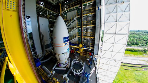
Launch of Sentinel-2A tonight

The first satellite in the two-satellite-mission, Sentinel-2A, is going to be launched this night. The launch from Europe’s Spaceport in Kourou, French Guiana, on 23 June is set for 01:52 GMT (03:52 CEST). A Vega launcher is going to take the satellite into space.

For everybody who is interested in the lunach:

ESA is going to broadcast the event in a webstream that will begin at 01:00 GMT (03:00 CEST) and end at 04:00 GMT (06:00 CEST). A number of the key players in the mission will present on preparing the satellite for launch and discuss its benefits and applications.

The Sentinel-2 mission is part of the Copernicus, a program for terrestrial observations in support of services such as forest monitoring, land cover changes detection, and natural disaster management.

The Sentinel-2 mission consists of optical satellites (Sentinel-2A and Sentinel-2B). The satellites will have a spatial resolution of 10, 20 and 60m, depending on the bands and the field of view, the swath of view will be up to 290km covering the earth from 56°S up to 84°N and will revisit the equator every 5 days under the same conditions. ESA is following an open data policy.

ESA

Launch of Sentinel-2A

VV04


Did you like this post? Read more and subscribe to our monthly newsletter!

Read on
Search