#Business #Featured #Fun #Ideas

Top 100 Geospatial Companies and Ecosystem Map – 2021

The wait is over! We are delighted to announce the list of the Top 100 Geospatial Companies and Startups for 2021.

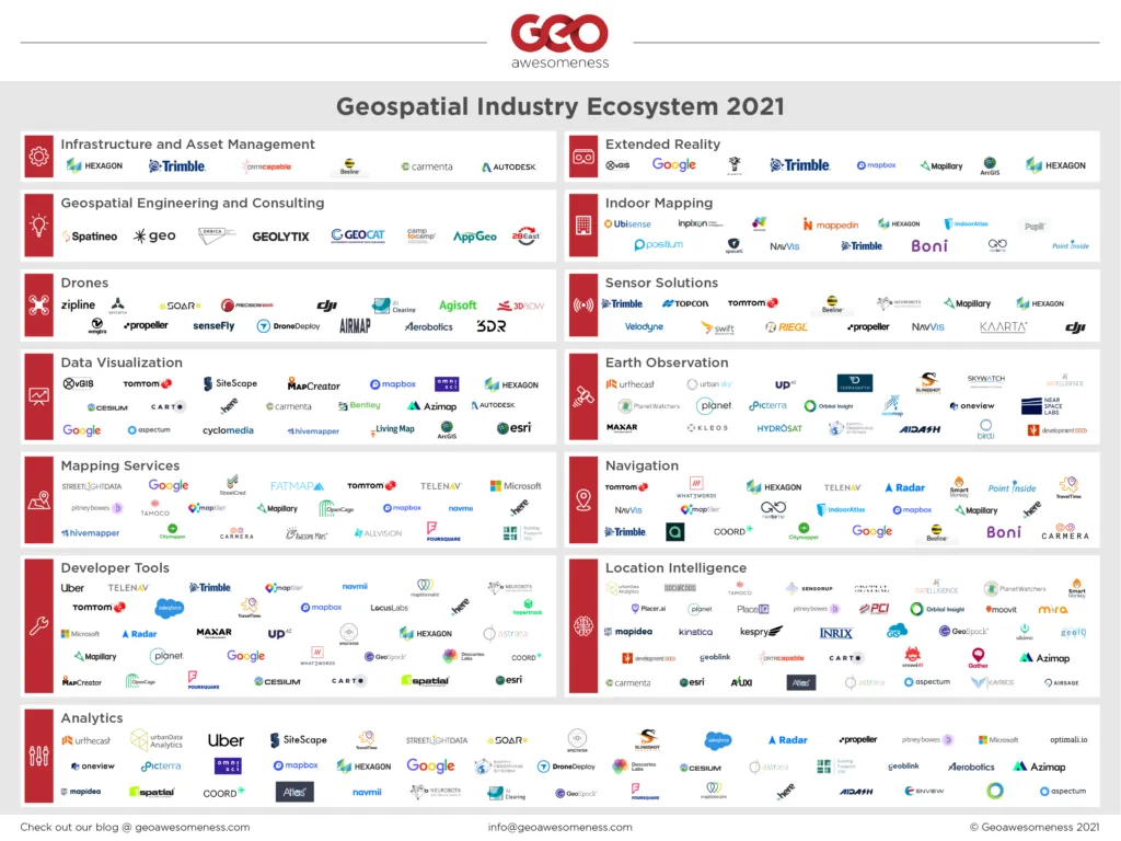
The team has been working on updating the list for the past few months now. We are delighted that together with our list of the top 100 geospatial companies, we are also releasing the first version of the Geospatial companies ecosystem map!
Top 100 Geospatial Companies

We have different file sizes and formats for the ecosystem map. You can send us an email at info@geoawesomeness.com

The primary objective of the list is to celebrate the work of these wonderful companies and create awareness regarding the diversity and range of companies working to make the world a better place through the use of geospatial data and tools.

The first list was published back in 2016 and this year’s list has been compiled by Muthu and Aleks. You will find their contact details below.

If you are interested in networking and staying up to date about the geospatial industry, join us at the geoawesomeness digital meetups.

Muthukumar kumar https://www.linkedin.com/in/muthukumarkumar
Aleksander Buczkowski https://www.linkedin.com/in/aleksanderbuczkowski/


Geoawesomeness Top 100 Geospatial Companies 2021
(listed alphabetically)

No. Company Name Website
1 3DR https://www.3dr.com/
2 Agisoft https://www.agisoft.com/
3 AI Clearing https://www.aiclearing.com/
4 Airmap https://web.archive.org/web/20240227231539/https://www.airmap.com/
5 AngelSwing https://www.angelswing.io/
6 AppGeo https://www.appgeo.com/
7 ArGIS https://www.argis.com/
8 Aspectum https://aspectum.com/
9 Autodesk https://www.autodesk.com/
10 Avuxi https://www.avuxi.com/
11 Awesome Maps https://awesome-maps.com/
12 Azavea https://www.azavea.com/
13 AziMap https://www.azimap.com/
14 Beeline https://beeline.co/
15 Bentley https://www.bentley.com/
16 Bird.i https://www.hibirdi.com/
17 Carmenta https://carmenta.com/en/
18 Carto https://carto.com/
19 Cesium https://cesium.com/
20 CityMapper https://citymapper.com/
21 DataCapable https://datacapable.com/
22 Descartes Labs https://www.descarteslabs.com/
23 Development Seed https://developmentseed.org/
24 DroneDeploy https://www.dronedeploy.com/
25 Enview https://www.crunchbase.com/organization/enview
26 EOS Data Analytics https://eos.com/
27 Esri https://www.esri.com/en-us/home
28 Estimote https://estimote.com/
29 Foursquare https://foursquare.com/
30 Gather https://gatherhub.org/
31 Geolytix https://geolytix.co.uk/
32 GIS Cloud https://www.giscloud.com/
33 Google https://www.google.com/
34 Here https://www.here.com/en
35 Hexagon https://hexagon.com/
36 Hivemapper https://hivemapper.com/
37 Inpixon https://www.inpixon.com/
38 Kaarta
39 Kayrros https://www.kayrros.com/
40 LocusLabs https://locuslabs.com/
41 Mapbox https://www.mapbox.com/
42 Mapcreator https://mapcreator.io/
43 Mapidea https://www.mapidea.com/
44 Mapillary https://www.mapillary.com/
45 Mappedin https://www.mappedin.com/
46 Mapsimise https://mapsimise.com/
47 MapTiler https://www.maptiler.com/
48 Maptionnaire https://maptionnaire.com/
49 Maxar https://www.maxar.com/
50 Microsoft https://www.microsoft.com/en-us/maps
51 Mira https://mira.co/
52 Nearmap https://www.nearmap.com
53 NextNav https://nextnav.com/
54 Niantic https://nianticlabs.com/
55 OmniSci https://www.omnisci.com/
56 OpenCage https://opencagedata.com/
57 Optimali.io https://www.optimali.io/
58 Orbital Insight https://orbitalinsight.com/
59 PCI Geomatics http://www.pcigeomatics.com/
60 Picterra https://picterra.ch/
61 Pix4D https://www.pix4d.com/about-us
62 PlaceIQ https://www.placeiq.com/
63 Placer https://www.placer.ai/
64 Planet https://www.planet.com/
65 PlanetWatchers https://www.planetwatchers.com/
66 Propeller Aero https://www.propelleraero.com/
67 Pupil https://pupil.co/
68 Radar https://radar.io/
69 Riegl http://www.riegl.com/
70 Safegraph https://www.safegraph.com/
71 SalesForce https://www.salesforce.com/
72 Satelligence https://satelligence.com
73 SenseFly https://www.sensefly.com/
74 SensorUp https://sensorup.com/
75 SkyCatch https://skycatch.com/
76 Skywatch https://www.skywatch.com/
77 SmartMonkey https://smartmonkey.io/
78 Soar https://soar.earth/index.html
79 SocialCops https://socialcops.com/
80 Spaceti https://www.spaceti.com/
81 SparkGeo https://sparkgeo.com/
82 Spatial AI https://www.spatial.ai/
83 Specator https://spectator.earth/
84 Swift Navigation https://www.swiftnav.com/
85 Targomo https://www.targomo.com/
86 Tectonix tectonix.com
87 Telenav https://www.telenav.com/
88 TomTom https://www.tomtom.com
89 Topcon Positioning https://www.topconpositioning.com/
90 TravelTime https://traveltime.com/
91 Trimble https://www.trimble.com/
92 Uber https://www.uber.com/
93 Ubisense https://ubisense.com/
94 UP42 https://up42.com/
95 Urban Data Analytics https://urbandataanalytics.com/
96 Urban Sky https://urbansky.space/
97 Urthecast https://www.urthecast.com/
98 vGIS https://www.vgis.io/
99 What3Words https://what3words.com/
100 Wingtra https://wingtra.com/


Update: Duplicate entries were removed and the companies that should have featured in the original list were added on 25th Jan 20:30 CET. 


Did you like this post? Read more and subscribe to our monthly newsletter!

Say thanks for this article (2)
The community is supported by:
Become a sponsor
#Business
#Business #Featured
Demystifying satellite data pricing: A comprehensive guide
Aleks Buczkowski 11.9.2023
AWESOME 7
#Business #Environment
Major milestone achieved towards building a green supply chain with the Supply Chain Data Partnership’s new global location register
Nikita Marwaha Kraetzig 12.8.2023
AWESOME 1
#Business #Contributing Writers #Fun #People
History of GIS | ESRI – A Pioneer in GIS Technology
Sebastian Walczak & Nikita Marwaha Kraetzig 07.26.2024
AWESOME 1
Next article
#Ideas #People

Location, Location, Location – 1st Digital Meetup of 2021!

We are back with our first Geoawesomeness Digital Meetup for 2021! We are delighted to partner with our friends over at TravelTime platform to talk about how we can use transport and travel time data to choose the right home, office, or retail location.

Choosing where to live, work or open a new business means having the right location data at your fingertips. With transport and travel time data, we can get a more complete picture of the best areas to relocate to or invest in. Join us for this discussion as we explore how you can use transport and travel time data to gain unique insights and make better, more informed decisions on property and real estate.

About Geoawesomeness Digital Meetup

The main objective for us to host these meetups is to bring together the geospatial community to talk about the latest and greatest in the geospatial sector. Think of these events as an open-source project aimed at enabling conversations and cross-industry cooperation. Each event has at least one speaker from the industry that is using geospatial data and tools to solve problems.

In 2020, we hosted 8 meetups in total and we had a blast doing it. More than 3000 GeoGeeks from all over the world attended the events so if you are looking for (virtual) opportunities to network with the geospatial community, the Geoawesomeness Digital Meetup is the place to be!

The event is hosted by Muthu and Aleks. You will find their contact details below.

Muthukumar kumar https://www.linkedin.com/in/muthukumarkumar muthu@geoawesomeness.com
Aleksander Buczkowski https://www.linkedin.com/in/aleksanderbuczkowski/ aleks@geoawesomeness.com
Read on
Search