#Business

Tagg GPS Plus pet tracker monitors location and temperature of your dog

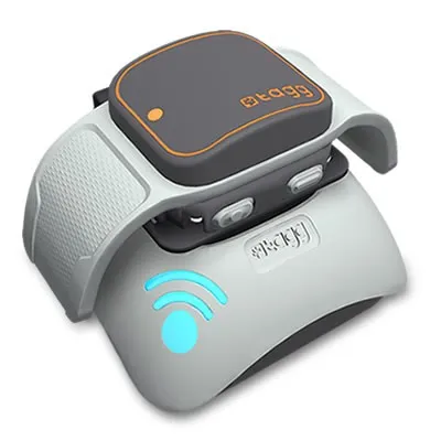
Tagg-GPS-Plus-Pet-Tracker-dockingstation-rtIf you’re a nervous pet owner Tagg has launched something for you, a new version of its popular location-enabled GPS collar. With its first generation device launched in 2012 Tagg set the standard in pet trackers market. The new version keeps the core features of the original intact while improving some of its shortcomings.

Essentially Tagg’s pet tracker looks like a slightly more elaborate dog collar. Using a companion app, you can look at where your pet is and set up safe zones with a simple geofencing tools. If your pet leaves the designated safe zone, you’ll instantly get an alert. The data are transferred using a GSM module in the device via Verizon cellular network.

But that’s not all. There’s also an accelerometer, which keeps track of fitness stats for your pet, much like fitness trackers and smartwatches do for us. Additionally the new generation of the device features an ambient temperature sensor which can alert you if your pet is experiencing unhealthy levels of heat or cold.  Another improvement is a battery life. The first generation of Tagg last 3-4 days on one charge. Tagg says the new device should only need to be charged two or three times a month, which is a big improvement.

In addition Tagg is also partnering with home monitoring company Alarm.com. This means that your home automation system will be able to respond to your pet’s activity e.g. control A/C system.

The device is priced at $119.95 + around $8/per month for Verizon’s GSM connection.

Say thanks for this article (0)
The community is supported by:
Become a sponsor
#Business
#Business #Fun #Ideas #Science
Next Generation Map Navigation: Is It Based on AR Smart Glasses?
Nianhua Liu 07.19.2024
AWESOME 2
#Business #Contributing Writers #Fun #People
History of GIS | ESRI – A Pioneer in GIS Technology
Sebastian Walczak & Nikita Marwaha Kraetzig 07.26.2024
AWESOME 1
#Business #Featured #GeoDev
Geo Addressing Decoded Part 2: Beyond Coordinates – Exploring the Depth and Impact of Geo Addressing
Aleks Buczkowski 05.2.2024
AWESOME 4
Next article
#Business #Featured

CES 2015: The Spatial Connection

The International CES 2015 (Consumer Electronics Show), one of the most anticipated tech events in the world or as some would like to call it, “the biggest tech show of the year”, concluded a day ago. Thousands of companies showcased a staggering number of new and exciting products. In some sense, it was the “christmas market” of the consumer electronics world!

But what does a consumer electronics event, however celebrated, got to do with the next-gen developments in the Spatial industry? Well, everything! 

The Spatial industry has been a niche one for a long time but things are certainly changing. If Google’s entry in the mapping industry back in 2005 with Google Maps was any indication, the CES 2015 most certainly a sign of the exciting times ahead for the Spatial Industry.

CES 2015: The Spatial Connection

Be it Self-driving cars or UAVs or Wearables that were showcased at the CES 2015, they all have a Spatial connection. While it would be almost impossible to cover all the cool gadgets and cars that were showcased at CES this year, some of the most notable devices/cars (with a spatial connection) were

The Self-driving cars of tomorrow require high precision maps and highly accurate positioning and maps are the bastion of the Spatial industry. Wearables like Fitness trackers and SmartWatches usually have a GPS besides other sensors that can aid in providing location information. UAVs have already proved their worth as great tools for mapping (Read more).

Look at any Geospatial company that has been successful in the last 5 years and you will find that they have transformed a lot. TomTom has its line of fitness trackers, HERE is working on Connected Cars, ESRI and CartoDB on Location Analytics and Big Data while Trimble and Hexagon have focussed on conglomeration of different Spatial solutions.

CES 2015 showed us a glimpse of what the future holds for the Spatial industry. The GIS profession is evolving and at a rapid pace. We could either choose to restrict ourselves to visualization of the location data or start expanding our horizons to include data analytics and IoT for the next-gen Spatial applications.

Read on
Search