Really How Big is the Idea of Big Data? Passionate About Big Data? Must See Video Here!
I am pretty sure that some folks like me who are passionate about Big Data, would find this video very interesting.
Really, how big is the idea of Big Data?, nicely articulated in this video.
Have fun watching!
Source:EMC Big Ideas

#GeoDev


Next article
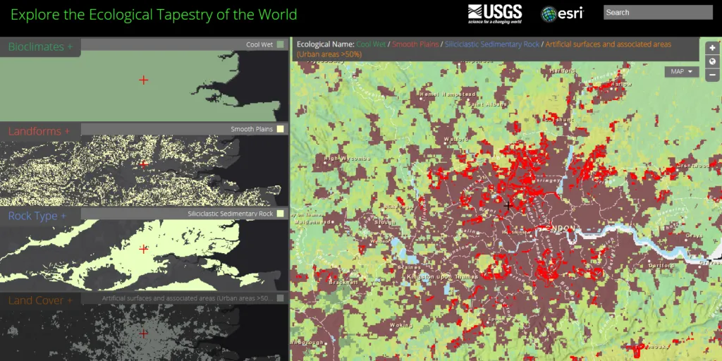


ESRI and the US Geological Survey (USGS) and Esri developed the most detailed global ecological land units map in the world. The map shows raster data of a resolution 250m and it’s fully interactive. It allows for viewing 5 different layers of data in 5 separate windows which is a little bit different approach than typical GIS layers overlay but in practice it works really well. Randy Vaughan, ESRI’s Manager of Content Engineering commented:
The globe was divided in cells (Ecological Facets) at a base resolution of 250 meters. The Facets were then characterized (attributed) with four input layers that drive ecological processes: bioclimate, landform, lithology, and land cover parameters. The layers chosen were the best available in terms of accuracy, currency, and global coverage. The result was a global raster data layer with 47,650 unique combinations of the four input layers. The Facets were then aggregated into 3,923 ecological land units (ELUs).
Esri says the purpose of the map is to provide web-based data for land managers, scientists, conservationists, developers, and the public to use for global, regional, and landscape analysis and accounting” and I must admit that we like it a lot!.
source: ESRI

