Quantum Geospatial: Beyond The Limits of Big Data

For years, geospatial systems have followed a simple idea: collect more data and decisions will improve. Cities now use sensors, phones, cameras, and satellites to build digital twins that simulate how urban systems behave. At small scales, this works well. But when we try to model entire cities, the system starts to break down.
The problem is no longer collecting data. It is processing it fast enough to make useful decisions.
Classical computers solve problems step by step. To optimize something like traffic, they evaluate one route, then another, then another. This works for a small area, but as cities grow, the number of possible paths increases extremely fast. Research on large urban systems shows how complexity increases as more components are modeled together. When moving from individual systems to entire cities, the number of interactions between transport, infrastructure, and environmental factors grows rapidly, making real-time analysis significantly harder for classical approaches.
Because of this, most systems rely on shortcuts. These heuristics find good enough answers, but not always the best ones. In traffic systems, this can create cascading problems. A route that looks efficient for one driver may create congestion when thousands follow it. Work on large-scale mobility systems highlights a key difficulty: optimizing routes for many vehicles at the same time without shifting congestion from one part of the network to another.
Another challenge is complexity. City systems depend on many factors at once, including weather, time of day, events, and infrastructure changes. Classical systems struggle to link these variables together. Research on high-dimensional geospatial modeling shows how quickly these interactions become difficult to compute. As the number of variables increases, the system must consider many more combinations at once, which significantly increases computational cost and makes real-time processing challenging.
Even when solutions exist, they are expensive. Large-scale optimization systems require significant computing power and energy. Advances like high-speed route optimization methods improve performance by up to two orders of magnitude, but they do not remove the underlying scaling problem. Similar challenges arise in broader discussions of geospatial big-data systems and route optimization at scale.
A simple way to understand this is to think of a maze. A classical computer tries to solve it by exploring one path at a time. That works when the maze is small. But for a city, there are too many paths to explore.
This article looks at what happens when we try a different approach. It explains how quantum computing changes the way problems are represented, where it may help in geospatial systems such as optimization and pattern detection, and why the future is likely to be a mix of classical and quantum methods rather than a full replacement.
A Different Approach: Quantum Computation
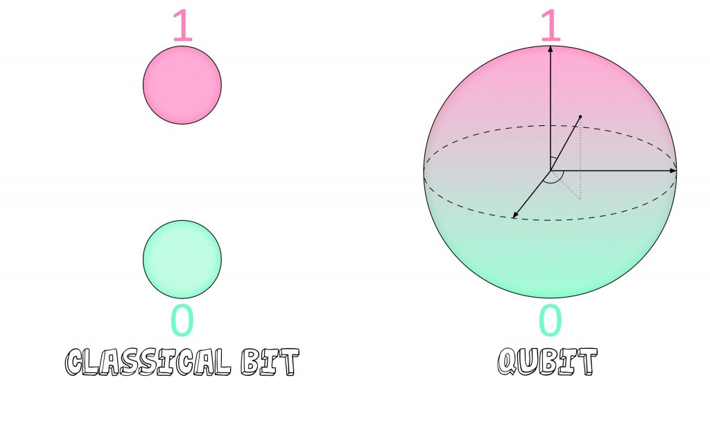
Quantum computing changes how problems are represented rather than just speeding them up. Instead of bits that are either 0 or 1, it uses qubits, which can exist in multiple states at once. This idea, called superposition, allows the system to encode many possible solutions simultaneously rather than checking them one by one. IBM’s overview of quantum computing describes how this shifts computation from step-by-step search to working with probability distributions.
Source: Fermilab
This matters for geospatial problems because many of them involve exploring large solution spaces. Instead of evaluating each route or configuration separately, quantum systems reshape the search so that better solutions become more likely. In simple terms, it is less about trying every path and more about guiding the system toward good ones.
Two additional properties make this possible. Entanglement links variables together so changes in one part of a system affect another, which is useful for modeling connected urban systems. Interference helps amplify better solutions while reducing weaker ones. Comparisons of quantum vs classical computation explain how this differs from traditional trial-and-error approaches.
These ideas are already being explored in real scenarios. Experiments show how quantum methods can be applied to routing problems, though still at a limited scale.
Quantum systems are still early and technically challenging. They require specialized hardware and are often accessed through cloud platforms rather than owned directly. But they introduce a different way of thinking about computation, one that is especially relevant for problems where the number of possibilities becomes too large for classical systems to handle efficiently.
Optimization at Scale
Optimization means finding the best way to do something, like routing vehicles through a city. This becomes difficult when thousands of vehicles are involved, because the number of possible routes grows very quickly.
Early experiments show how quantum methods can help. Work like Volkswagen’s traffic optimization project explored routing for large fleets, where each vehicle is assigned a different path instead of sending everyone through the same “fast” route. This helps reduce congestion rather than shifting it. Volkswagen’s Lisbon quantum shuttle experiment, a real-world trial, demonstrated this idea at smaller scale, where buses were dynamically routed based on city-wide traffic conditions.
Similar ideas are being explored in logistics. Studies on quantum approaches for logistics optimization and industry work like DHL’s technology-driven delivery systems show how routing, fuel use, and delivery efficiency can be improved by better optimization methods.
These systems are still early, but the direction is clear. Instead of optimizing one vehicle at a time, the system treats the entire city or network as a connected problem and finds more balanced solutions.
High-Dimensional Data and Pattern Detection
Modern satellites capture far more than standard images. Hyperspectral data includes hundreds of spectral bands, forming what are often called data cubes. These allow detection of subtle patterns such as vegetation health or water quality. Research on quantum machine learning for Earth observation data highlights how complex these datasets can become. Hyperspectral imagery can contain hundreds of spectral bands per pixel, creating high-dimensional data where patterns depend on correlations across many layers rather than a single image.
The challenge is scale. Processing these high-dimensional datasets is computationally expensive, and classical systems often struggle to extract patterns efficiently. Work on quantum models for satellite imagery analysis explores how quantum approaches may handle these feature spaces differently.
One advantage is pattern detection. Instead of relying on large labeled datasets, some quantum approaches aim to identify structures with fewer examples. Quantum methods for hyperspectral analysis suggest that subtle signals, which may be missed by classical models, can be captured more effectively.
These methods are still experimental, but they point toward faster analysis of large geospatial datasets and improved detection of small or complex changes, especially in environmental monitoring scenarios.
The Current Reality: Hybrid Systems
Quantum computing is still in an early stage. Today’s systems, often described as noisy intermediate-scale quantum (NISQ) devices, are sensitive and not fully reliable on their own.
Because of this, most real use cases follow a hybrid approach. Classical systems handle data processing, storage, and user interaction, while only the hardest optimization tasks are sent to quantum hardware. For instance, the AWS Braket platform shows how both systems can work together rather than replacing each other.
This setup allows gradual adoption. PennyLane, the tool for hybrid quantum models, and frameworks such as Qiskit let developers experiment with quantum methods alongside classical systems. It also lowers the barrier to entry. Cloud-based access means organizations can test quantum approaches without building their own hardware.
In practice, quantum computing is not replacing geospatial systems. It is becoming a supporting layer for problems that are difficult for classical methods alone.
Developing Practical Intuition
Quantum computing is not needed for every problem. For small tasks, classical systems are still faster, cheaper, and more reliable.
It becomes relevant when there is a clear computational bottleneck. This usually appears in problems with large search spaces, high-dimensional data, or strict time constraints. Discussions on quantum advantage in complex systems highlight where classical methods begin to struggle.
Typical signals include:
- very large optimization problems (e.g., routing at city scale)
- datasets with many layers (e.g., hyperspectral imager)
- situations where approximate solutions are not sufficient
- strong interactions between many variables
In these cases, hybrid or quantum-inspired methods may offer an advantage. Insights from advanced quantum-enabled geospatial analysis show that these approaches are explored through hybrid workflows, focusing on optimization and high-dimensional problems. The key takeaway is that quantum methods are being used selectively, not as full replacements for classical systems.
A practical starting point is not full quantum adoption, but preparation. This includes structuring data, identifying bottlenecks, and experimenting with hybrid methods so integration becomes easier as the technology matures.
Geospatial systems are moving beyond collecting data toward understanding complex systems in real time. Classical methods took us far, but they struggle as scale and complexity increase.
Quantum approaches introduce a different way to handle these challenges. Not by replacing existing systems, but by extending what is possible in optimization and high-dimensional analysis.
The change is happening slowly, but it’s important. It includes geospatial analysis like routing through cities and remote sensing detection of changes in the environment. The goal is not just to compute faster, but to make better decisions.
The future of geospatial intelligence will not be defined by a single technology. It will be shaped by how classical and quantum systems work together to understand and manage the world more effectively.
Did you like this article? Read more and subscribe to our monthly newsletter!

#Contributing Writers
Next article


With the world’s major economies still heavily reliant on fossil fuels, and the net zero targets set by the Paris agreement of 2015 still a pipe dream, our planet is on the brink of devastating climate change. Despite concerted efforts of global governments and grass-roots activists, most companies are failing to decarbonise at the necessary rate, and many of them will still be producing significant volumes of greenhouse gases by 2050.
One solution which has increasingly been used by companies to compensate for this lack of progress is carbon offsetting—an appealing solution by which companies can plot a route to net zero not by reducing their own footprint, but through funding projects that sequester carbon or reduce overall global emissions.
However, in recent years, trust in the carbon offsetting market has been massively eroded, with details emerging about bogus projects or exaggerated claims. Is there a way to ensure that carbon offsetting projects are really doing what they claim to do, or is the whole system fundamentally flawed? Satellites may provide an answer…
Carbon offsetting and the carbon market
First, a quick summary of the carbon market, which has two main elements. The first is the regulatory carbon permit system, whereby large-scale polluters like power plants, factories, and other industrial infrastructure properties are incentivised financially to reduce their carbon emissions. The other is carbon offsetting—which is often voluntary—in which polluters compensate for their emissions, rather than reducing them.
The carbon market operates on a system known as ‘cap and trade’. Through cap-and-trade, governments set a cap on the level of emissions permissible by large polluters, and this cap is divided into a number of carbon permits—effectively forming an allowance to emit a specific amount of greenhouse gases (GHGs). Permits are priced by metric tonne of CO2, and can be bought directly from the government, or traded between companies if they are over their limit or have a surplus of credits. Each year, the cap on total emissions gets lower, and individual permits get more expensive. The world’s largest and longest-running cap-and-trade system is the European Union Emissions Trading System (EU ETS), which started in 2005.
Carbon offsetting is another way for companies to contribute to a global reduction in emissions, but instead of directly reducing their own, they compensate for them through investing in projects that reduce or sequester GHGs. Carbon offsetting can be part of the carbon market if the relevant regulatory system permits the use of ‘carbon credits’ as a means to offset excess emissions. In these cases, one carbon credit is treated as equivalent to one tonne of CO2 under the cap-and-trade system.
How does carbon offsetting work?
The story of carbon offsetting began in 1989, when the company Applied Energy Services financed an agriforest in Guatemala to ‘offset’ the building of a coal-fired power station. Today, businesses can buy carbon credits from projects that involve renewable energy generation, reforestation or afforestation (establishing a forest on land not previously forested), carbon capture and storage etc. Carbon offsetting by businesses is voluntary—and they often do it to meet their own sustainability targets or to raise their environmental credentials—but it has also been common for offsetting credits to be permitted in cap-and-trade systems, subject to varying rules.
Unfortunately, businesses have tended to hide behind carbon credits while making little effort to reduce actual emissions, leading to understandable accusations of greenwashing and an overall loss of trust in the concept of offsetting. Even more alarmingly, carbon offsetting projects have often been misleading and failed to deliver on their promises. Earlier this year, a stinging report into the carbon standards organization Verra, issuer of the Verified Carbon Standard (VCS), indicated that as little as 10% of its offsetting projects produce the emissions reductions they claim—while some projects are entirely fraudulent, producing no reduction at all.
In this context, it’s not surprising that the EU ETS has not permitted the use of international offset credits in its carbon market since 2020. However, as part of the agreement signed at COP26, polluters will be able to continue offsetting emissions, subject to certain criteria, and predictions are that this market could be worth $200 billion by 2050.
Whether it’s part of a cap-and-trade system or the voluntary market, it is crucial to ensure carbon offsetting projects are effective and genuine. As such, projects are required to adhere to principles of Additionality (must lead to a new and measurable reduction in emissions that would not have otherwise occurred), Permanence (must have long-term durability) and Verification (by an independent and accredited organization). Aside from the now-discredited VCS, independent standards include the Gold Standard, and the Climate Community and Biodiversity Standards (CCBS).
It is vital that carbon offsetting projects adhere to these principles—not just to ensure they contribute to the overall goal of reducing greenhouse gas emissions, but also to increase credibility and rebuild trust.
Satellite data monitoring offsetting
Many reforestation or carbon sequestering projects are located in remote or hard-to-reach areas, which presents a challenge for measuring their success. Here, satellites have significant advantages over aerial or drone monitoring, not to mention conventional in-person measurement, all of which are costly and time-consuming. Using SAR and multispectral data, combined with vegetation indices, biomass and carbon stocks can be estimated with a high degree of accuracy. Frequent revisits can confirm project permanence, and high-resolution imagery enables analysts to view activity in both the project area and control areas, to ensure additionality.
There are now several companies turning to satellite data to verify the success of carbon offset projects. One such company is Pachama, which uses three types of satellite imagery—optical-infrared, radar, and lidar—in combination with artificial intelligence to monitor and verify the effectiveness of forest-based projects. They also provide a platform for businesses to discover and invest in high-quality carbon offset projects that meet strict additionality, permanence, and verification criteria.
British company Sylvera specializes in providing independent, data-driven assessments of carbon offset forestry projects using satellite data and advanced analytics. Sylvera’s platform offers project ratings that help businesses identify high-impact projects. Tel Aviv-based Albo Climate is another company using machine-learning algorithms and multispectral data to measure ‘above ground biomass’ (AGB) carbon stocks.
One of the most interesting companies in this sector is CarbonStack, increasing transparency through innovative use of two technologies. The company supports afforestation projects, using blockchain technology to make a publicly accessible ledger of activities, and also utilising satellite observation for forest monitoring. CarbonStack has been using imagery from the Pléaides Neo constellation, whose 30cm resolution enables the company to identify individual trees. The companies monitored 50,000 trees planted across Europe in 2022—and provided significant time and cost savings when compared with drone or aerial photography.
Monitoring by satellite has another big benefit. As high-resolution satellites can measure carbon sequestration in areas as small as 10m2, they present an opportunity for small landowners to take part—and share some of that $200 billion market. This means that offsetting can benefit everyone, not just the multinational corporations or NGOs.
Satellite data = transparency = trust
It’s probably an uncomfortable truth, but one we should acknowledge, that for many industries, fully decarbonising may never be possible. Therefore, offsetting GHG emissions—authentically and verifiably—will have to be part of any net zero solution. To do this, we need transparency and trust.
By using remote sensing data and other technologies to assess, evaluate, and authenticate projects, companies like those above are generating a higher degree of transparency in carbon offsetting projects, and thereby going some way to restoring trust in the sector. This, in turn, makes it a more reliable tool for addressing climate change.
Satellite imagery has a rich history when it comes to protecting our planet—it was of course the iconic ‘Earthrise’ photo of Earth rising over the moon’s horizon, taken during the Apollo 8 mission in 1968, which served as a catalyst for the environmental movement. The trend looks set to continue: by ensuring the authenticity of carbon offsetting projects, satellites can play a major role in our transition towards net zero.
Did you like this post? Follow us on our social media channels!
Read more and subscribe to our monthly newsletter!

