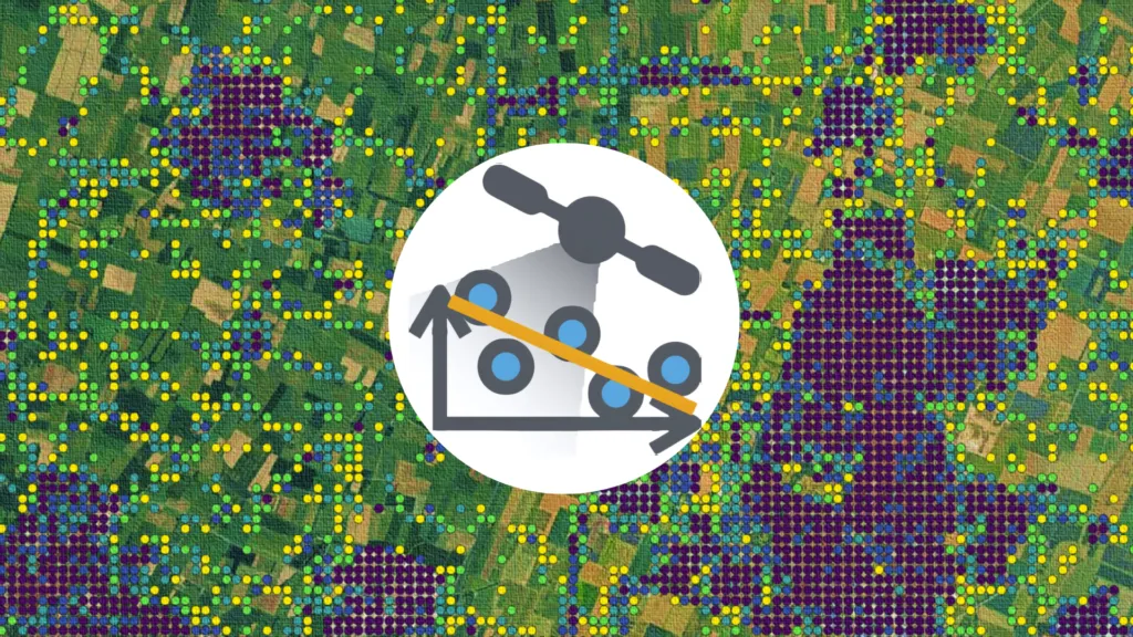
In the ever-changing world of geospatial technology, being able to analyze and visualize synthetic aperture radar (SAR) data is crucial for understanding surface deformations and structural movements.
That’s where InSAR Explorer comes in. It’s a cool QGIS plugin that makes analyzing interferometric SAR (InSAR) time series data a breeze. With its set of features and simple interface, this plugin is useful for researchers and engineers as it allows users to dynamically visualize and analyze time series data from InSAR, making it easier to monitor ground displacement over time.
Dynamic Visualization of Time Series Data
InSAR Explorer Origins
InSAR Explorer’s main strength is its ability to show time series data dynamically for any selected InSAR point on the map. The author of this tool, Mahmud Haghighi, is a prominent figure in the field of remote sensing and geoinformation. He is particularly known for his contributions to SAR technology. As the author of InSAR, Haghighi’s commitment to enhancing the accessibility and usability of advanced geospatial analysis techniques has helped the scientific community better understand Earth’s dynamic processes.
Using InSAR Explorer
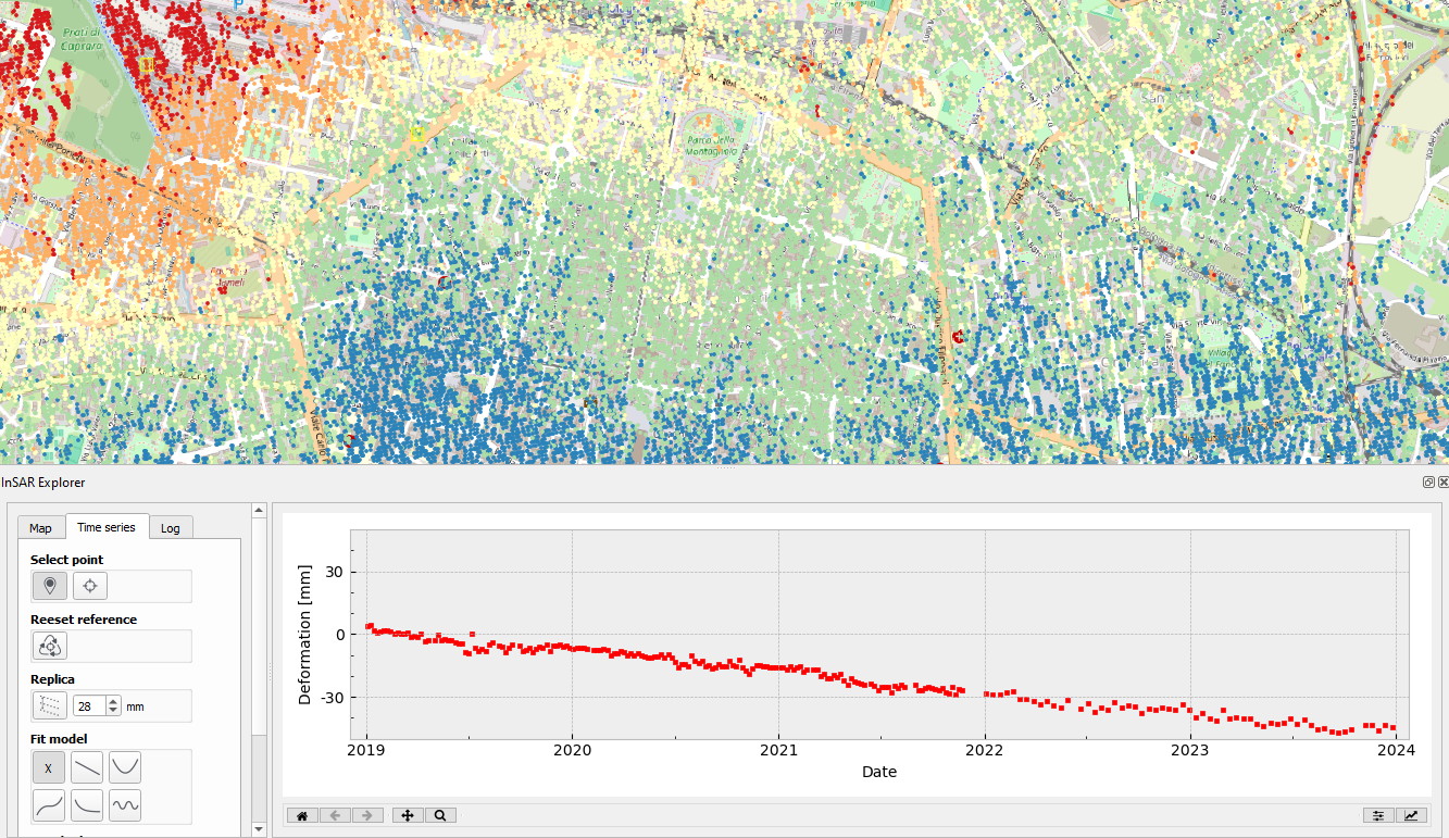
Once you’ve loaded an InSAR vector layer in QGIS, you can interactively select specific points and check out the area’s deformation history over time. This feature is key for keeping an eye on gradual surface displacements caused by natural or human-made processes, like tectonic activity, mining subsidence, or urban infrastructure settling.
The time series visualization feature lets users quickly spot patterns, anomalies, and trends, making it easier to figure out the extent and nature of surface deformations. It’s a pretty intuitive way to explore how SAR data changes over time, so you can get meaningful insights without having to do a lot of coding or data manipulation.
By simplifying the process of interpreting InSAR data, InSAR Explorer encourages creative applications in fields such as disaster management, urban development, and environmental monitoring – from users of all backgrounds.
Visualization of Time Series Data with InSAR Explorer
Setting a Referencing Point: A Key to Accurate Analysis
One of the best things about InSAR Explorer is that it lets you set a referencing point for the analysis.
In InSAR studies, picking an appropriate reference point is key because it acts as the baseline against which all the other measurements are compared. The reference point usually shows a stable spot that’s thought to be free of deformation, which makes sure that the measurements of relative movement are on point and meaningful.
For example, in a case study involving urban subsidence monitoring, it’s possible to select a stable building foundation as the reference point. By comparing deformation measurements relative to this fixed location, we can accurately assess areas of sinking ground and estimate its severity. InSAR Explorer streamlines this process, allowing usto set and modify the reference point with ease, thereby improving the precision of our analysis.
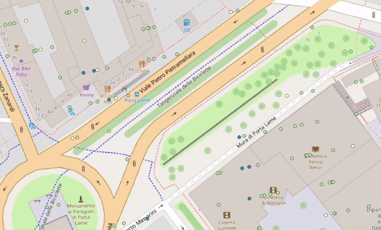
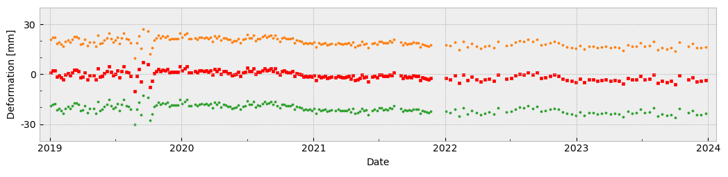
Plotting Replicas: Enhancing Data Comparison
InSAR Explorer allows users to plot replicas of time series data for comparative analysis. This feature is really useful when you need to evaluate multiple points or datasets at the same time. By plotting replicas, users can compare deformation patterns across different regions, identify correlations, and detect potential causative factors.
For example, in a landslide risk assessment project, researchers could select multiple points along the landslide-prone area and plot their time series replicas. This comparison helps us understand how far the displacement is and how it’s changing over time, which is essential for devising effective disaster risk reduction strategies. By making this complex analysis straightfoward and accessible, InSAR Explorer empowers individuals and organizations to proactively address environmental challenges and enhance community safety.
Model Fitting: Interpreting Deformation Trends
InSAR Explorer’s model fitting feature is a pretty powerful analytical tool.
It allows users to fit mathematical models to the observed time series data. You can use models like linear, polynomial, or seasonal fits to interpret underlying trends and predict future deformations.
For example, in a dam monitoring project, engineers can use model fitting to determine whether observed subsidence follows a linear pattern due to long-term settlement or exhibits seasonal variations linked to water levels.
The model fitting feature provides a clear visualization of the relationship between time and displacement, making it easier to identify deviations from expected behavior and assess the stability of the structure.
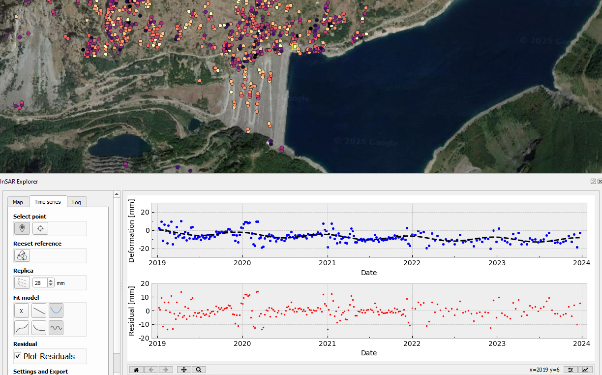
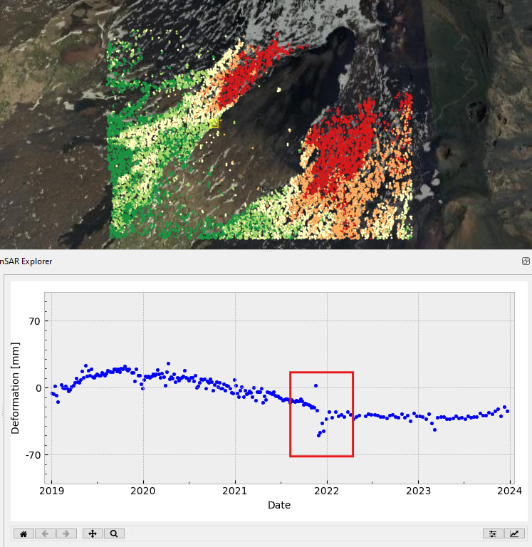
Plotting Residuals: Detecting Anomalies
InSAR Explorer offers another great feature that allows you to plot residuals, which represent the differences between the observed time series data and the fitted model.
This analysis is crucial for detecting anomalies in the data, which could mean there’s something unexpected occurring or there is a mistake in the data.
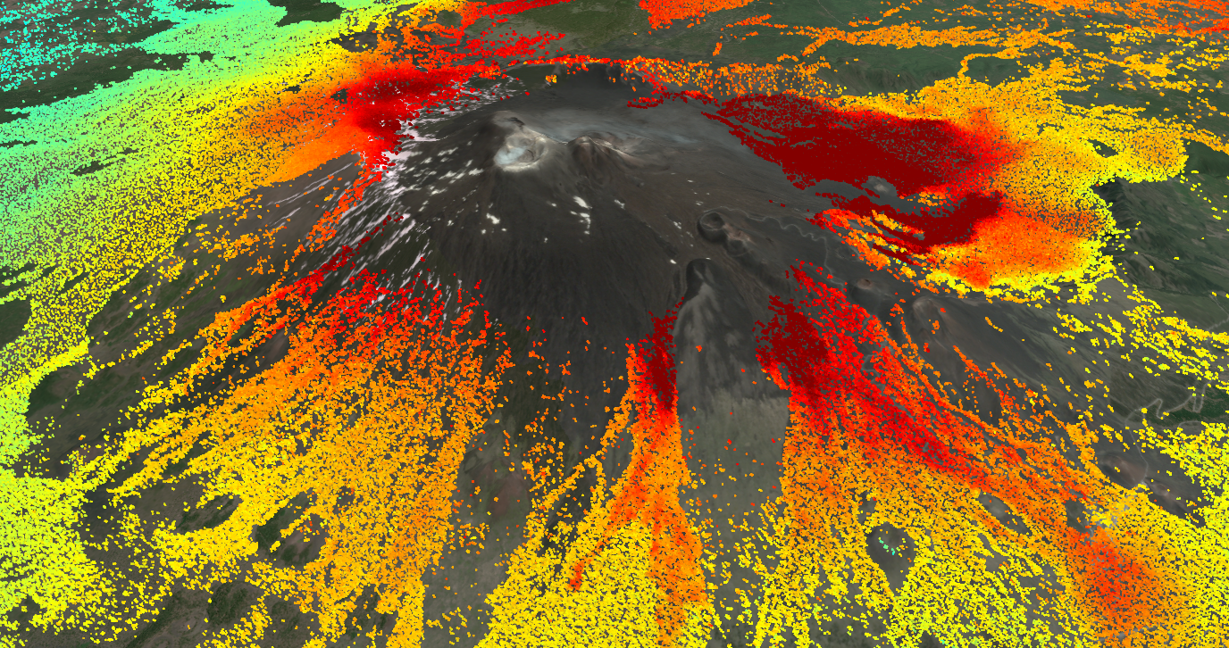
Let’s look at a case study on volcanic monitoring. By plotting residuals, scientists can easily spot sudden spikes in deformation that deviate from the expected trend. These spikes could signal increased volcanic activity or magma movement. This early warning system is essential for assessing risks and preparing for potential disasters.
Seamless Integration with Popular SAR Tools
InSAR Explorer is designed to work well with leading InSAR data processing tools, including SARvey, MintPy, MiaplPy, GMTSAR, and EGMS. This makes it easy to import time series data from different sources and formats, which makes the workflow smoother and reduces the need for manual data conversion.
The plugin supports both vector and raster data structures, so you can work with shapefiles, geopackages, or grd files, depending on the output format of your chosen processing tool. This flexibility makes InSAR Explorer a valuable asset for projects of all sizes and complexities.
Conclusion: Empowering InSAR Analysis with Intuitive Tools
InSAR Explorer is more than just a visualization tool—it is a comprehensive solution for exploring and interpreting InSAR time series data. By offering dynamic visualization, reference point setting, model fitting, and residual analysis, the plugin empowers users to uncover valuable insights into surface deformations and structural changes.
Whether monitoring urban infrastructure, assessing landslide risks, or studying environmental phenomena, InSAR Explorer is an indispensable tool for geospatial professionals. With its seamless integration into QGIS and compatibility with major SAR processing tools, it is set to play a pivotal role in advancing InSAR analysis and promoting data-driven decision-making in diverse applications.
If you’re ready to elevate your InSAR analysis capabilities, give InSAR Explorer a try – and unlock the full potential of SAR data in your projects.

Read more and subscribe to our monthly newsletter!


#Contributing Writers


Next article
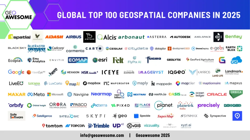

The wait is over! We are excited to officially unveil the Global Top 100 Geospatial Companies 2025 list—our annual ranking of the most innovative and influential companies shaping the geospatial industry.
This list, meticulously curated by a panel of industry experts for the 7th time, highlights the organizations leading the way in GIS, Earth Observation, AI-powered analytics, location intelligence, and more.
The Global Top 100 Geospatial Companies 2025 serves as a key resource for professionals, investors, and decision-makers looking to understand the evolving landscape of geospatial technology. From startups disrupting the market to established giants setting new benchmarks, this list reflects the diversity and dynamism of our industry.
Join us in celebrating these trailblazers who are shaping the future of geospatial technology and transforming our understanding of the world in this 2024 edition
The 2025 expert committee, a distinguished group of experts, brought together a diverse range of expertise and insights to curate the Global Top 100 Geo list. This year’s committee included:
- Sives Govender, Research Group Leader, CSIR, South Africa and Co- founder and coordinator of Environmental Information System-Africa
- Siau Yong, Director, GeoSpatial and Data & Chief Data Officer, Singapore Land Authority
- Osamu Ochiai, Senior Engineer, Manager for Satellite Applications and Operation Center at Japan Aerospace Exploration Agency
- Justyna Redelkiewicz, Head of Section Entrepreneurship and Environment at the European Union Agency for Space Programme (EUSPA)
- Chiara Solimini, Space Downstream Market Officer at the European Union Agency for Space Programme (EUSPA)
- Peter Rabley, CEO at Open Geospatial Consortium (OGC)
- Denise McKenzie, Manging Partner at PLACE Trust
- Dr. Nadine Alameh, Executive Director of the Taylor Geospatial Institute
- Paloma Merodio, VP at National Institute of Statistics and Geography of Mexico (INEGI)
and
- Aleksander Buczkowski and Muthukumar Kumar for Geoawesome
In the coming weeks, we will be sharing more analysis about the Geospatial industry and the ecosystem via our newsletter. Sign up to stay informed!
Sign up to our newsletter to stay updated
#GlobalTop100Geo 2025 Edition

AND here are the Global Top 100 Geospatial Companies of 2024 listed alphabetically.
| Previous Editions | Company name | Website |
| Part of 2022, 2023 and 2024 lists | 1Spatial | www.1spatial.com |
| Part of 2024 list | Agronomeye | www.agronomeye.com.au |
| Part of 2023 and 2024 lists | AIDASH | https://www.aidash.com/ |
| Part of 2022, 2023 and 2024 lists | Airbus Defence and Space | https://space-solutions.airbus.com |
| New entrant | Airteam Aerial Intelligence GmbH | https://airteam.ai/ |
| Part of 2022, 2023 and 2024 lists | Alcis Holdings Ltd | https://www.alcis.org/ |
| New entrant | Arbonaut | https://www.arbonaut.com |
| Part of 2022, 2023 and 2024 lists | ASTERRA | https://asterra.io/ |
| Part of 2019, 2021, 2022, 2023 and 2024 lists | Autodesk | https://www.autodesk.com |
| New entrant | Axelspace Corporation | https://www.axelspace.com/ |
| New entrant | Bee Maps (by HiveMapper) | https://beemaps.com |
| Part of 2019, 2021, 2022, 2023 and 2024 lists | Bentley | https://www.bentley.com/en |
| New entrant | BlackSky | blacksky.com |
| Part of 2023 and 2024 lists | Blue Raster | https://www.blueraster.com/ |
| Part of 2023 and 2024 lists | Cadcorp | https://www.cadcorp.com |
| Part of 2022 and 2024 list | Carmenta Geospatial Technologies | https://www.carmenta.com/ |
| Part of 2019, 2021, 2022, 2023 and 2024 lists | CARTO | https://carto.com/ |
| Part of 2021, 2022, 2023 and 2024 lists | Cesium | https://cesium.com/ |
| Part of 2023 and 2024 lists | CITYDATA | https://citydata.ai |
| New entrant | dataplor | https://www.dataplor.com/ |
| Part of 2019, 2021, 2022, 2023 and 2024 lists | Development Seed | developmentseed.org |
| Part of 2019, 2021, 2022, 2023 and 2024 lists | DroneDeploy | DroneDeploy.com |
| Part of 2024 list | e-geos | https://www.e-geos.it/en/ |
| Part of 2024 list | Earth Blox | https://www.earthblox.io/ |
| Part of 2022, 2023 and 2024 lists | Ecopia AI | https://www.ecopiatech.com/ |
| Part of 2022, 2023 and 2024 lists | Emu Analytics | www.emu-analytics.com |
| Part of 2023 and 2024 lists | Envitia Ltd | www.envitia.com |
| Part of 2023 and 2024 lists | EOMAP | eomap.com |
| Part of 2019, 2021, 2022, 2023 and 2024 lists | ESRI | www.esri.com |
| Part of 2024 list | Felt | http://felt.com/ |
| New entrant | FlyPix AI | https://flypix.ai/ |
| Part of 2023 and 2024 lists | Fugro | www.fugro.com |
| New entrant | Geolytix | https://geolytix.com/ |
| New entrant | GeoPard Agriculture | https://geopard.tech |
| New entrant | GeoWGS84 | https://www.geowgs84.com/ |
| Part of 2019, 2021, 2022, 2023 and 2024 lists | GIS Cloud | www.giscloud.com |
| Part of 2019, 2021, 2022, 2023 and 2024 lists | https://www.google.com/ | |
| New entrant | HawkEye 360 | he360.com |
| Part of 2019, 2021, 2022, 2023 and 2024 lists | HERE Technologies | https://www.here.com/ |
| Part of 2019, 2021, 2022, 2023 and 2024 lists | Hexagon | Hexagon.com |
| New entrant | HSR.health | https://www.hsr.health |
| Part of 2023 and 2024 lists | ICEYE | https://www.iceye.com |
| New entrant | Iconem | https://iconem.com/ |
| New entrant | Imageryst | https://www.imageryst.com/ |
| Part of 2024 list | IQGeo | https://www.iqgeo.com/ |
| Part of 2024 list | Kayrros | www.kayrros.com |
| New entrant | Land Life | https://landlifecompany.com/ |
| New entrant | Landmark Information Group | https://www.landmark.co.uk/ |
| Part of 2022, 2023 and 2024 lists | LiveEO | http://live-eo.com/ |
| Part of 2023 and 2024 lists | Locana | www.locana.co |
| Part of 2022 and 2024 list | LuxCarta | https://luxcarta.com |
| New entrant | MapAI | https://mapai.net/ |
| Part of 2019, 2021, 2022, 2023 and 2024 lists | Mapbox | https://www.mapbox.com/ |
| Part of 2021, 2022, 2023 and 2024 lists | Mapcreator | mapcreator.io |
| Part of 2023 and 2024 lists | Mapxus | https://www.mapxus.com/ |
| Part of 2024 list | Maply | https://maply.com |
| Part of 2021, 2022, 2023 and 2024 lists | Mappedin | www.mappedin.com |
| Part of 2019, 2021, 2022, 2023 and 2024 lists | MapTiler | https://maptiler.com |
| Part of 2019, 2021, 2022, 2023 and 2024 lists | Maptionnaire | https://maptionnaire.com/ |
| Part of 2022, 2023 and 2024 lists | Maxar Technologies | https://www.maxar.com |
| Part of 2019, 2021, 2022, 2023 and 2024 lists | Meta | https://www.meta.com/de/en/ |
| Part of 2021, 2022, 2023 and 2024 lists | Microsoft | https://www.microsoft.com/en-us/maps |
| New entrant | Navigine | https://navigine.com/ |
| Part of 2021, 2022, 2023 and 2024 lists | Nearmap | https://www.nearmap.com/us/en |
| Part of 2024 list | NextBillion.ai Pte Ltd | https://nextbillion.ai/ |
| Part of 2021, 2022 and 2024 list | NextNav | https://nextnav.com/ |
| Part of 2024 list | North.io GmbH | https://www.north.io |
| New entrant | Oasis City Lab | https://oasiscitylab.eu |
| New entrant | Ocean Ledger | https://www.ocean-ledger.com/ |
| Part of 2024 list | Oracle | http://www.oracle.com |
| Part of 2023 and 2024 lists | Orbica | https://orbica.world/?g=o |
| Part of 2023 and 2024 lists | Orbify | https://orbify.com |
| Part of 2019, 2021, 2022, 2023 and 2024 lists | Orbital Insight | https://orbitalinsight.com/ |
| New entrant | OroraTech | https://ororatech.com/ |
| Part of 2022, 2023 and 2024 lists | PASCO CORPORATION | https://www.pasco.co.jp/eng/ |
| Part of 2021, 2022, 2023 and 2024 lists | Picterra | www.picterra.ch |
| Part of 2019, 2021, 2022, 2023 and 2024 lists | Pix4D | https://www.pix4d.com/about-us |
| Part of 2022, 2023 and 2024 lists | PLACE | https://www.thisisplace.org |
| Part of 2019, 2021, 2022, 2023 and 2024 lists | Planet | https://www.planet.com/ |
| New entrant | Planetek Italia | https://www.planetek.it/ |
| Part of 2024 list | Precisely | https://www.precisely.com |
| Part of 2022, 2023 and 2024 lists | Regrid | https://regrid.com |
| Part of 2023 and 2024 lists | Safe Software | www.safe.com |
| Part of 2019, 2021, 2022, 2023 and 2024 lists | Satelligence | www.satelligence.com |
| Part of 2022 and 2024 list | Satellogic | www.satellogic.com |
| Part of 2024 list | SkyFi | https://www.skyfi.com/ |
| Part of 2019, 2021, 2022, 2023 and 2024 lists | Sparkgeo | www.sparkgeo.com |
| Part of 2024 list | Speckle | https://speckle.systems/ |
| Part of 2024 list | SuperMap Software Co., Ltd. | https://www.supermap.com/en-us/ |
| Part of 2023 and 2024 lists | SynMax | https://www.synmax.com/ |
| Part of 2022, 2023 and 2024 lists | Synspective Inc. | https://synspective.com/ |
| Part of 2024 list | Textomap | https://www.textomap.com/ |
| Part of 2019, 2021, 2022, 2023 and 2024 lists | TomTom | https://www.tomtom.com/ |
| Part of 2021, 2022, 2023 and 2024 lists | Topcon Positioning | https://www.topconpositioning.com/ |
| Part of 2019, 2021, 2022, 2023 and 2024 lists | Trimble | https://www.trimble.com/ |
| Part of 2021, 2022, 2023 and 2024 lists | UP42 | www.up42.com |
| Part of 2024 list | vGIS Inc. | https://www.vGIS.io |
| New entrant | Vizzuality | https://vizzuality.com |
| New entrant | Woolpert, Inc. | https://www.woolpert.com |
| Part of 2022, 2023 and 2024 lists | xyzt.ai | www.xyzt.ai |
Frequently Asked Questions (FAQs)
Q1. How was the list created?
Our selection process was meticulous. We reviewed over 1000 companies (up from 800 last year), narrowing them down to a shortlist of 261 based on past listees (2019, 2021, 2022, 2023 and 2024), expert recommendations, and nominated companies. A distinguished expert committee then voted on the shortlisted companies. The final Global Top 100 Geospatial Companies 2025 list reflects the collective judgment and consensus of these experts.
Q2. Is the list ranked?
No, the list is not a ranking. Companies are listed alphabetically to equally recognize all 100 leading geospatial companies without implying any hierarchy.
Q3. Who was part of the expert committee?
The 2025 expert committee, a distinguished group of experts, brought together a diverse range of expertise and insights to curate the Global Top 100 Geo list. This year’s committee included:
- Sives Govender, Research Group Leader, CSIR, South Africa and Co- founder and coordinator of Environmental Information System-Africa
- Siau Yong, Director, GeoSpatial and Data & Chief Data Officer, Singapore Land Authority
- Osamu Ochiai, Senior Engineer, Manager for Satellite Applications and Operation Center at Japan Aerospace Exploration Agency
- Justyna Redelkiewicz, Head of Section Entrepreneurship and Environment at the European Union Agency for Space Programme (EUSPA)
- Chiara Solimini, Space Downstream Market Officer at the European Union Agency for Space Programme (EUSPA)
- Peter Rabley, CEO at Open Geospatial Consortium (OGC)
- Denise McKenzie, Manging Partner at PLACE Trust
- Dr. Nadine Alameh, Executive Director of the Taylor Geospatial Institute
- Paloma Merodio, VP at National Institute of Statistics and Geography of Mexico (INEGI)
and
- Aleksander Buczkowski and Muthukumar Kumar for Geoawesome
Q4. What information did the expert committee consider?
Geoawesome announced an open call for nominations on October 1, 2024. Companies voluntarily provided insights through a structured questionnaire, detailing their vision, operations, and impact. The committee also relied on their extensive industry experience and independent research to make informed decisions.
Q5. What was new in the nomination process this year?
For the 2025 edition, we introduced key enhancements to improve the nomination process:
? Enhanced Focus on Core Competencies – We placed a stronger emphasis on core geospatial competencies and emerging industry trends shaping the future.
? Streamlined Nomination Process – The nomination form was simplified, removing basic company data fields and reducing the total number of questions to make the process more efficient.
Q6. What were the selection criteria?
There were no rigid selection criteria imposed on the expert panel. Each expert applied their unique perspective to assess the companies, ensuring a broad and well-rounded evaluation. As in past years, our expert panel will review all nominations and decide the final list. The nomination phase focused on the following aspects:
- Product and Impact on the Industry
- Innovation and Technological Advancement
- Contribution to the Community
- Commitment to Diversity, Equity, and Inclusion (DEI)
- Environmental, Social, and Governance (ESG) Practices
Q7. My company deserves to be on the list! How can I improve my chances?
We understand your passion, and we acknowledge that many deserving companies couldn’t be included due to space constraints. The best way to improve your chances for next year’s list is to nominate your company when the 2026 nominations open. The details companies share during the nomination process play a crucial role in helping our experts understand their impact. If you would like to take a look at the questions for the 2025 nomination, check out our google doc.
? Want to stay updated? Sign up to our newsletter to get notified when nominations open.
Q8. I have feedback or further questions. Whom should I contact?
We value your feedback and are happy to address any questions! You can reach out to Muthu at muthu@geoawesome.com.
We encourage you to share this announcement and participate in the discussion on social media using the hashtag #GlobalTop100Geo. Let’s celebrate the organizations that are making a difference in the geospatial world!
#GlobalTop100Geo 2024 Edition
Looking for the previous edition? Here you go!

