#Featured #GeoDev #Ideas

LandScan USA ambient population data is now free for public use

As America starts to lift coronavirus shelter-in-place restrictions, Oak Ridge National Laboratory (ORNL) has made its high-resolution population distribution database, LandScan USA, open and free for public use. Accurate population estimates are imperative for epidemiological prediction of disease progression and modeling the consequent stresses on healthcare infrastructure and economic activities.
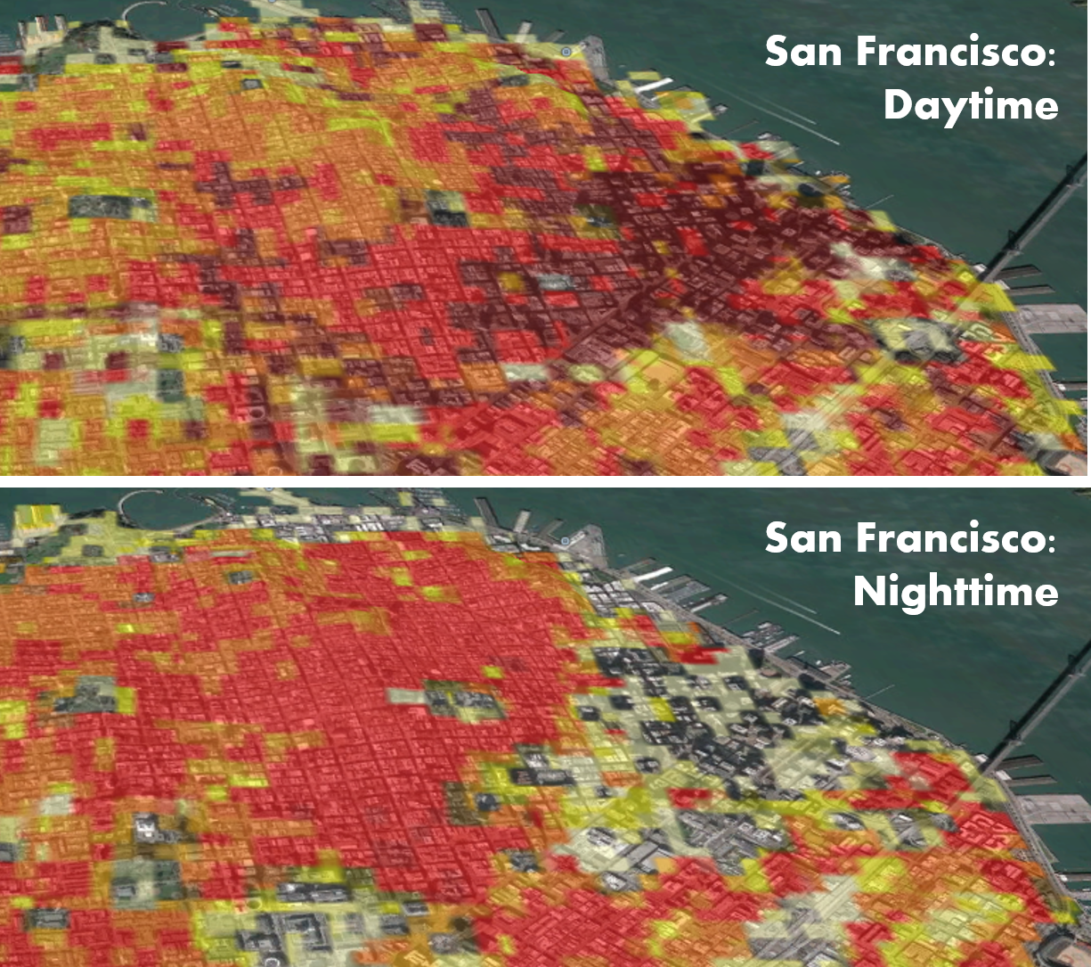
LandScan data free

Courtesy: Oak Ridge National Laboratory/US Dept of Energy

LandScan is widely known as the gold standard of population and mapping data in the US because it captures both daytime and nighttime activity of the population. Most national censuses count populations by measuring where people reside rather than where they work or travel frequently. But LandScan provides a 24-hour average of where people are located, rather than just recording where people sleep at night.

Ambient population data is critical to understand the population density in cities like Philadelphia, New York City, and Boston where a huge wave of out-of-city commuters arrives every day to work. This is especially true in today’s times when states are planning to reopen economic activities even as the coronavirus pandemic continues to upend life as we know it.

Also see: International space agencies plan hackathon to tackle COVID-19 pandemic

Emergency agencies routinely rely on LandScan data to coordinate disaster response and recovery. And according to ORNL, the model’s level of detail is already proving to be a valuable tool for researchers tracking the spread of COVID-19.

Budhu Bhaduri, director of ORNL’s National Security Emerging Technologies Division, says, “Our goal is to provide improved situational awareness and insight into what is happening in different regions of the country and how different areas and populations are responding and reacting to conditions and interventions.”

LandScan data is available at a resolution of about 90 meters or 300 feet for the Continental United States, Hawaii, and Alaska. To access the data, you can visit the GeoPlatform online portal which has been made available through the US Department of Homeland Security’s Homeland Infrastructure Foundation-Level Data program.

Note: The data is a Geodatabase raster, which means QGIS users would likely need to use the arcgisbinding package or get a GeoTiff version from an ArcGIS user.

Say thanks for this article (0)
The community is supported by:
Become a sponsor
#Featured
#Business #Featured
Global Top 100 Geospatial Companies – 2024 Edition
Avatar for Muthukumar Kumar
Muthukumar Kumar 01.31.2024
AWESOME 10
#Business #Featured
Introducing Planet Insights Platform: Easier, Faster, and More Cost-Effective Insights
Avatar for Sponsored Article
Sponsored Article 06.14.2024
AWESOME 1
#Featured #People
Create a More Inclusive and Diverse Geospatial Community with Akama Fund and Esri’s Geospatial Student Accelerator Scheme
Nikita Marwaha Kraetzig 03.13.2024
AWESOME 2
Next article
#Business #Featured #Ideas

Tom Cruise, NASA’s movie shoot in space: What we know so far

Love him or hate him, you cannot deny Tom Cruise has continuously pushed the envelope of action stunt work by a leading Hollywood actor. Be it scaling the tallest building in the world for Ghost Protocol, being the first actor to ever perform a HALO jump in Fallout, or holding his breath underwater for an insane six minutes for Rogue Nation, Cruise really works hard to earn his Mission: Impossible franchise paycheck.

And now, for his next jaw-dropping feat, Cruise wants to shoot a feature film aboard the International Space Station (ISS). If his stunt history is anything to go by, it wouldn’t be surprising to see Cruise hang off the ISS to conduct a spacewalk – though no details of this upcoming adventure are available yet.

What we do know is that NASA has validated a scoop reported by Deadline, which claimed that Cruise is working with NASA and Elon Musk’s SpaceX to shoot an action film in outer space. “It’s not a Mission: Impossible film and no studio is in the mix at this stage… But this is real, albeit in the early stages of liftoff,” the report read.

In a tweet earlier today, NASA Administrator Jim Bridenstine confirmed that the US space agency is indeed collaborating with the 57-year-old actor to shoot a film aboard the ISS. “We need popular media to inspire a new generation of engineers and scientists to make NASA’s ambitious plans a reality,” Bridenstine said.

Even though NASA did not mention what role SpaceX would be playing in this arrangement, it is safe to assume that Cruise would ride to the ISS in the SpaceX Crew Dragon capsule. “Should be a lot of fun!,” is what Musk said in reply to Bridenstine’s tweet.

This exciting news could not have come at a more opportune time since later this month, NASA astronauts Robert Behnken and Douglas Hurley will be the first crew to fly in the Crew Dragon capsule. NASA and SpaceX have zeroed down on May 27 as the date for the historic first astronaut launch aboard a private spacecraft from US soil.

Read on
Search