

Managing geospatial infrastructure at scale is not an easy task. As the demand for high-performance, cloud-native GIS solutions grows, automation becomes essential. This article explores how Quarticle leverages a Kubernetes (K8s) operator to streamline GeoServer Cloud management, integrating Helm templates, ArgoCD, and Vault to enhance scalability, reliability, and operational efficiency.
Why build a K8s operator for GeoServer?
Managing GeoServer instances can be time-consuming, particularly in large-scale deployments. Quarticle’s K8s operator was designed to address these challenges by focusing on:
- Automation and efficiency: Automate GeoServer workflows for smoother integration into larger data pipelines.
- Reliability through declarative configurations: Ensuring consistent performance with Kubernetes Custom Resource Definitions (CRDs) and Helm templates.
- Scalability and modernization: Transforming legacy systems into self-healing, cloud-native applications while enabling independent scaling.
K8s Operator as a piece of data management pipeline
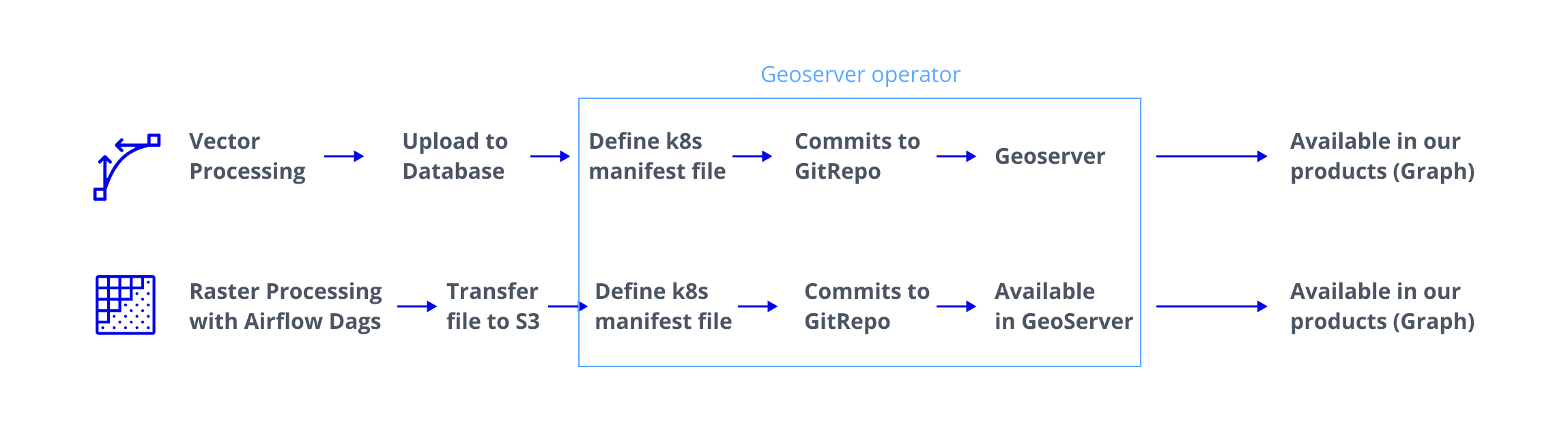
How it works: The actual workflow
The K8s operator simplifies complex operations through a streamlined workflow:
- Triggering updates: The user commits Custom Resource Definitions or updated values files to a Git repository.
- Deployment automation: Helm templates deploy the updated configurations.
- Operator action: The K8s operator reacts to create, update, or delete events and interacts with the GeoServer REST API.
- Reconciliation: The operator maintains the desired state by continuously aligning Kubernetes and GeoServer objects.
Architecture overview
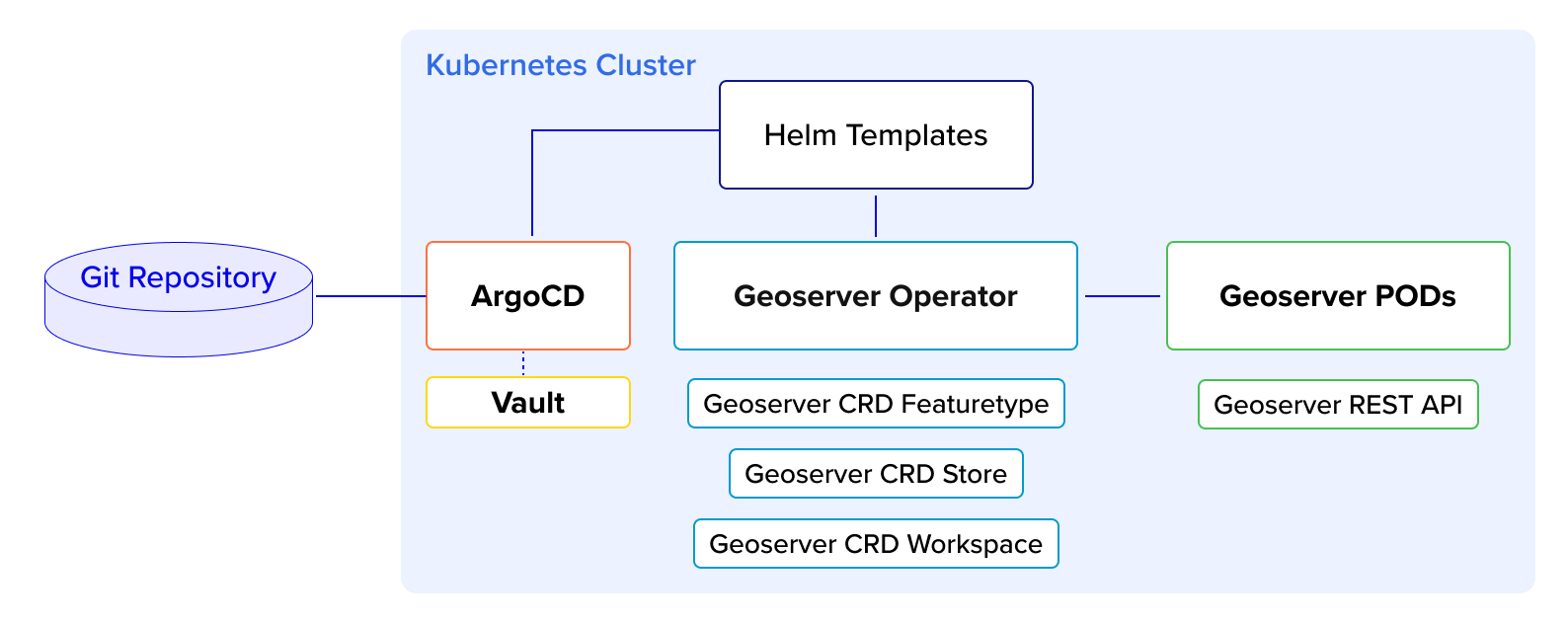
To further enhance efficiency, Quarticle integrates ArgoCD into the workflow:
- GitOps-driven deployments: Changes in the Git repository automatically trigger updates in GeoServer.
- Real-time updates: Continuous deployment ensures the system always aligns with source control, minimizing downtime and manual intervention.
Key challenges addressed
Quarticle’s implementation also tackles common hurdles in automating GeoServer, such as:
- Object lifecycle synchronization to maintain consistency across Kubernetes and GeoServer: Maintaining consistency between Kubernetes and GeoServer objects is critical for operational reliability, preventing data discrepancies that could disrupt workflows.
- Managing dependencies and integrating external resources: Advanced tools and methodologies simplify the inclusion of external resources, making workflows more modular and adaptable.
Quarticle solutions are fully OGC-compliant, ensuring seamless interoperability with open geospatial standards. This guarantees that organizations can integrate our tools effortlessly into existing GIS workflows while maintaining compatibility with industry-wide data exchange protocols. (OGC compliance enables better data sharing, ensures long-term sustainability, and aligns with best practices for geospatial system interoperability.)
Combining Kubernetes, Helm, ArgoCD, and Vault creates a robust framework for managing GeoServer resources with high reliability. As GeoServer Cloud development progresses, Quarticle remains committed to expanding support for additional objects and workflows, contributing to the broader GeoServer ecosystem.
About Quarticle
Quarticle is a technology-driven company specializing in cloud-native GIS solutions that enable organizations to process, analyze, and interpret geospatial data efficiently. Our high-performance, scalable, and secure solutions are built with open-source technologies, ensuring full interoperability and no vendor lock-in. We also offer expert GIS consulting, covering geodata engineering, software development, and DevOps, to help clients integrate and optimize geospatial systems within their existing infrastructure.
Partner with us
We’re looking for tech partners and innovators who share our passion for scalability, automation, and cloud-native geospatial solutions. If you’re interested in pushing the boundaries of GIS and cloud-native technology, let’s connect. Drop us a message at contact@quarticle.ro or visit www.quarticle.ro.

#GeoDev


Next article
How Earth Observation is Transforming Wildfire Monitoring and Management
Editor’s Note: This article is part of Geoawesome’s ongoing effort to raise awareness and foster dialogue within the geospatial sector. As an independent voice in the community and as a source of market intelligence, we see it as our mission to share insights that inform, inspire, and spark collaboration. We’d love to hear your thoughts—reach us anytime at info@geoawesome.com.
Wildfires are among the most devastating natural disasters, threatening ecosystems, human lives, and property. With climate change accelerating the frequency and severity of these events, timely and accurate monitoring has become critical. Earth observation technologies are at the forefront of this effort. These technologies provide invaluable data for early detection, real-time tracking, and post-fire assessment. This in-depth paper will present the impact of satellite-based EO on wildfire management, highlighting stakeholders, significant advancements, and the expanding role of AI in forest fire mitigation.
Key Players, Data Providers and End-Users in Wildfire Monitoring
Notable Developments and News
Advancements in AI Integration
Artificial Intelligence is revolutionizing wildfire management by processing vast datasets to forecast risks and fire behavior. In California, AI algorithms now analyze meteorological data, vegetation moisture levels, and historical fire patterns to predict fire paths in seconds. These forecasts are becoming critical tools for firefighters and emergency managers.
Read more: The Guardian – How AI is Revolutionising Firefighting
Global Efforts in Satellite Deployment
In September 2024, Sentinel-2C was launched by Arianespace as part of the Copernicus program. The new satellite enhances monitoring of forests, urban expansion, and environmental emergencies, including wildfires. It adds to the world’s largest environmental monitoring program, reinforcing Europe’s EO capabilities.
Challenges in Early Detection
Despite the progress in EO and AI, early detection alone cannot prevent fires from becoming uncontrollable. Rapid fire spread due to wind and extreme heat remains a significant challenge. As Wired reported, even with faster detection, the combination of climate extremes and fuel buildup can overwhelm response efforts, underlining the need for integrated fire strategies.
CO2 Emissions from Wildfires
Wildfires are now a major source of greenhouse gases. In 2024, fires contributed to a record increase in global CO2 levels. The Guardian highlighted the role of fires in driving climate change, creating a feedback loop that could lead to more frequent fires in the future.
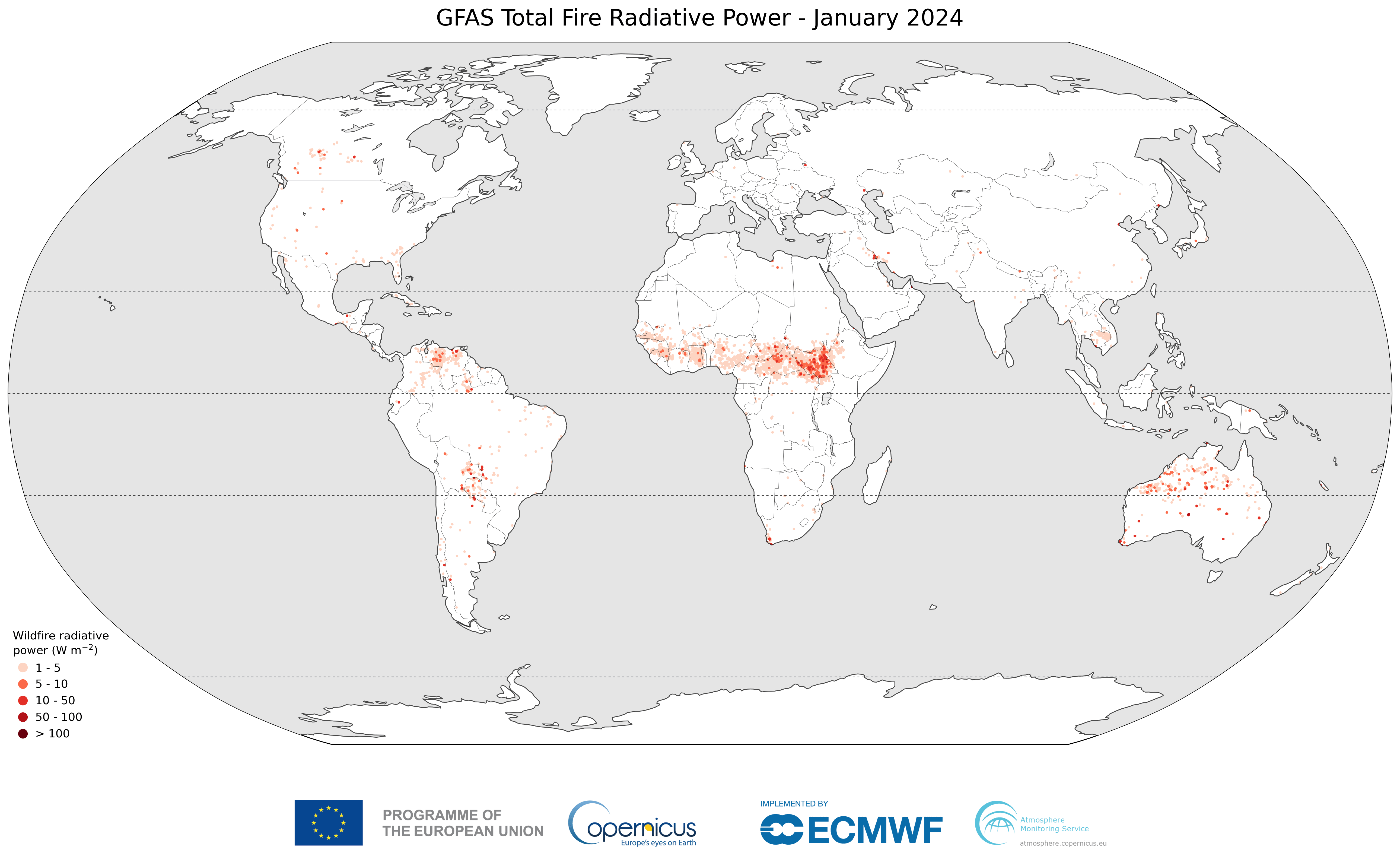
Regional Highlights: The Americas
The Copernicus Atmosphere Monitoring Service noted that the Americas experienced exceptional wildfire activity in 2024. Drought conditions and extreme weather were key contributors. EO data has been essential in understanding these patterns and coordinating international response efforts.
Wildfires in the United States
According to the latest NOAA report, wildfire activity in the U.S. continues to trend upwards, with longer fire seasons and increased burn areas. Real-time satellite mapping and weather forecasting are now critical components of federal and state fire response strategies.
Maps and Products for Wildfire Monitoring
- US Wildfire Activity Web Map (Esri): A dynamic map showing current fire locations, perimeters, and updates.
- FIRMS Fire Map: Real-time satellite data for active fires.
- Esri Disaster Response Program: A suite of tools and support for organizations managing wildfire and disaster response efforts.
Looking Ahead
The future of wildfire monitoring depends on better satellite coverage, smarter AI tools, and easier access to fire data. New technologies and community efforts like Earth Fire Alliance are helping people around the world detect and respond to fires more effectively.
However, challenges remain. Investment in resilient infrastructure, interdisciplinary cooperation, and public engagement are essential to translate EO data into effective action.
How do you see the role of EO evolving in wildfire response? Are there local efforts or technologies that deserve more attention? Send me an email at sebastian@geoawesome.com and join the conversation.
Do you like this article? Read more and subscribe to our monthly newsletter!

