#Business #Featured #People

Jobs in Geo – Week 12

At Geoawesomeness, we’re working on creating an interactive job portal for companies to submit jobs and for job-seekers to look for jobs in the geospatial industry.

For the past two months so, we’ve been sharing jobs on our LinkedIn and in weekly blog posts. While it certainly is not our final product, it allowed us to get some quick feedback and share some awesome jobs submitted by companies while we develop and test the job portal. We hope that you enjoy this selection of Geoawesome jobs!


Featured Job: 3d Mapping Algorithms Engineer at Hivemapper

?San Francisco, USA

Hivemapper builds living, evolving 3d maps of the world. As we improve our technologies in speed, accuracy, information content, flexibility, and many other ways we consistently develop and deploy state of the art algorithms to solve these problems. In this role, you will collaborate with teammates across the company to design, develop, test, and deploy sophisticated solutions to a wide variety of challenging problems.

The ideal candidate for this role not only has strong technical implementation skills, but a demonstrated fluency in flexible mathematical and algorithmic thinking. This role exists in both standard and senior forms depending on the experience of the applicant.


You can read more about how Hivemapper aims to replace static satellite-based maps.


Quality Assurance Engineer Intern at understand.ai
?Karlsruhe, Germany
https://understandai-jobs.personio.de/job/86382


Community Manager at Safe Software

?Surrey, Canada
https://www.safe.com/careers/community-manager/


UX Researcher at Google Maps

?Sydney, Australia
https://tinyurl.com/y2bv5ren


Here are the positions that we have previously posted, some on our LinkedIn:


If you see any positions that would be interesting for our community, you can also submit a job using the online form for us to review and include in our list!

Are there any specific things you’d like to see in our job portal? Feel free to get in touch.

Want to get your dose of Jobs in Geo directly to your inbox? Subscribe to our jobs newsletter here.

Say thanks for this article (0)
The community is supported by:
Become a sponsor
#Business
#Business #Featured #GeoDev
Geo Addressing Decoded, Part 3: Diving into the Key Features of Precisely’s Geo Addressing System
Aleks Buczkowski 06.29.2024
AWESOME 4
#Business #Events
SatSummit 2024 Reflections: The evolving landscape of Earth Observation
Avatar for Florian Fichtner
Florian Fichtner 05.22.2024
AWESOME 9
#Business #Contributing Writers #Fun #People
History of GIS | ESRI – A Pioneer in GIS Technology
Sebastian Walczak & Nikita Marwaha Kraetzig 07.26.2024
AWESOME 1
Next article
#Business #Featured

Google Maps AR navigation review: Early users share their experience

Using Google Maps for walking directions is arguably more difficult than following the magical blue dot while driving a vehicle. Though the Google Maps app shows a cone of view indicator to tell you which way you’re facing, it’s not uncommon to find that the blue dot itself has got your location wrong – especially in ‘urban canyons’.

In fact, if you go by the study released by location data company PlaceIQ, the average variance of smartphone positioning in a city is roughly 93 feet – varying from a low of 1-meter inaccuracy to a whopping high of 204 meters!

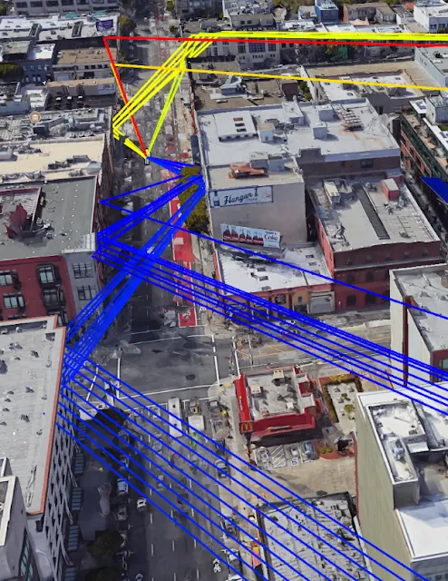
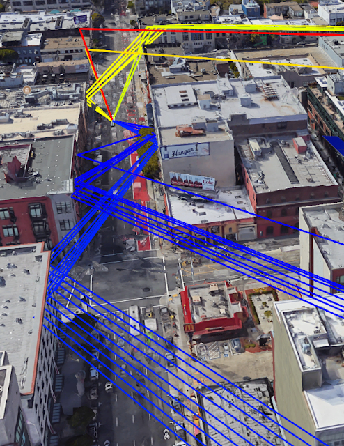
GPS signals bouncing off facades in an urban environment. Image courtesy: Google

So, when Google Maps made augmented reality-powered navigation available to all Local Guides Level 5 and above for testing earlier this month, we were quite stoked. First announced at its I/O Developer conference in May 2018, this nifty new feature uses your smartphone camera as a sensor and combines Visual Positioning Service (VPS), Street View, and machine learning technologies to identify your position and orientation more accurately than ever.

Simply put, Google Maps is giving you the ability to overlay walking directions over real-world environments. And it looks something like this:

Also noteworthy is the emphasis the company has put on the safety of the users. For example, the app prompts you to hold the phone down when you’re walking straight, lest you bump into lamp posts or other people! If you ignore this instruction, the screen would automatically become dim – not a bad thing for a functionality that could actually prove to be a serial battery-drainer.

However, the strain on the phone’s battery is not the only limitation of this new technology. Google has its work cut out to make AR-enhanced walking directions work everywhere, such as in low light conditions, snowstorms, or heavy rains. Which is why it would be sometime before the feature is released to the public at large. But those who are helping Google test the technology have been raving about the resourcefulness of AR-powered navigation.

Are you among the lucky few who have access to AR Walking Navigation in Google Maps? We would love to hear what you think about the feature in the comments!

Read on
Search