
Satellite imagery is an essential component that OpenStreetMap mappers use every day to improve the ever-growing wiki world map. And things just got a lot better for OSM with DigitalGlobe’s new satellite imagery service for OpenStreetMap that makes two new global satellite imagery layers directly available inside OpenStreetMap’s ID Editor.
The two new layers i.e. DigitalGlobe-Premium and DigitalGlobe-Standard are going to help OSM mappers easily identify and trace ever-evolving human-made features across the world and aid them in their quest to expand OpenStreetMap.
Previously, OSM mappers were able to use Bing and Mapbox Satellite imagery layers for tracking features.
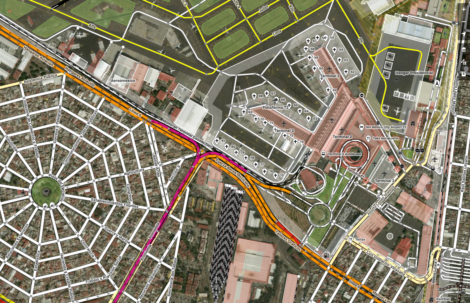
Mexico City, Mexico. Imagery (c) DigitalGlobe. Map (c) OpenStreetMap contributors
A bit more info regarding the two Satellite imagery layers, as listed on the OpenStreetMap Wiki page regarding the satellite imagery service
- DigitalGlobe-Premium is a mosaic composed of DigitalGlobe basemap with select regions filled with +Vivid or custom area of interest imagery, 50cm resolution or better, and refreshed more frequently with ongoing updates
- DigitalGlobe-Standard is a curated set of imagery covering 86% of the earth’s landmass, with 30-60cm or resolution where available, backfilled by Landsat. Average age is 2.31 years, with some areas updated 2x year.
Why is this important?
OpenStreetMap relies upon the hundreds of thousands of users who edit the map – adding & deleting roads, buildings, places and a lot of other human-made structures. More often than not, this is a process that involves satellite imagery serving as a background canvas that the mappers can use to trace. Having accurate, high-resolution and up-to-date satellite imagery inside OpenStreetMap editors makes this a lot easier for the community to keep OSM updated and accurate. (Related: Google Maps vs OpenStreetMap).


#Ideas


Next article


Recently I had a pleasure to talk to guys from TerraLoupe – startup that does an amazing with geo data and AI. Take a look our conversation.
Could you tell me what is TerraLoupe? What’s your story?
TerraLoupe is a young people and technology driven AI company. Our core competence is the automatic recognition of objects in geo images and the full digitalization of the outdoor environment via deep learning.
Manuela Rasthofer, CEO, Sebastian Gerke, CTO, and Christian Schaub, COO, founded the company on the premise that understanding geo image data could fundamentally improve decision making. Before, Manuela has worked in the defence industry and had experiences in global sales. Thus, she came along the idea to combine geo images with artificial intelligence technologies. Sebastian was researching in the field of image recognition at the Fraunhofer Institut in Berlin. Christian worked several years in the consulting sector and beside that also in Israel and was very experienced in start-up business cases. Together they formed a balanced team of three persons with each having a different skill set.
How did you manage to grow over these years? From starting point what did you achieve?
TerraLoupe grew through a three step process. First, TerraLoupe invested in the development of its algorithms and technology. Second, TerraLoupe delivered their first pilot projects to leading DAX companies. Third, TerraLoupe is building up a scalable product via platform for its target customers.
What is your business model? Where do you aim to sell your products? Who is your client?
TerraLoupe’s technology provides object recognition in aerial images via machine learning/ deep learning. TerraLoupe offers digital and automatic information of our environment especially in the domains of houses, roads, vegetation and rails. We are developing the next geo search & information engine for business.
We aim to sell our product to the industry. We currently mainly target the automotive, insurance and energy sector.
It will be a tricky question, but could explain to us what are aerial images and who provide them?
Aerial images are usually taken by airplane or drones and provide an aerial perspective on the earth. Aerial images are taken by governmental institution or private flight companies. These airplanes have certain cameras with which they take the images.
The automotive industry has strong players like Here and TomTom. How do you plan to cope with them?
We do not want to cope with Here or TomTom rather we would like to provide them our service or cooperate with them. We provide a technology that is specialized on object detection of geo images, in particular, aerial images. This is a technology that neither Here nor TomTom provides and we settle down in niches.
Data from Aerial Images are slightly less accurate than Data from fully equipped cars with sensors but provide way more feedback. Do you plan any cooperation?
Aerial images do provide a bigger scope and a very high resolution up to three cm. Thus, images from fully equipped cars are not explicitly more accurate, but provide a different angle. In order to involve every angle it could be useful to implement terrestrial images. So yes, we are interested in cooperations and are already in discussions.
Providing data for insurance companies is a groundbreaking idea! Do you think your product can change the industry from inside?
We believe that our data has the potential to make value estimation in insurance more precise and accurate. Thus, we think we can change parts of this industry from inside.
Big Data, Deep Learning, Artificial Intelligence. Could you explain to us how your application understands geo image data?
We use deep learning – more precisely neural networks – to analyze our geo images. We do that for a huge amount of data so that Big Data can derived.
I am assuming that you have a strong team behind it all?
Yes, we have a very strong, international and interdisciplinary team. We see each other not only as colleagues but also as friends who enjoy to take up new challenges and tasks.
Do you focus on EMEA only? Do you plan to expand your business to other regions?
For now, we focus on EMEA but we look forward to go abroad to the US and China soon. We have won the German Accelerator and are looking forward go to Silicon Valley this year. Furthermore, we look forward to open our US office next year.
And the last question. Do you have any advice for our readers who just entered gee business industry?
We would recommend them to work with companies who use the newest technologies in order to scale their business idea or business model. We noticed that much of the industry can be renewed and many companies use processes and data that is slow or not as accurate and useful as possible.

