Harnessing UAV Technology to Support Municipal Solid Waste Management

The Relevance of MSW
Municipal Solid Waste (MSW) management poses a challenge in many countries, especially in regions with insufficient waste management infrastructure.
According to a UN Report 2018, several regions in Africa are identified as critical hotspots for waste mismanagement. In 2012, only 55% of MSW was collected across the continent, and 4% was recycled, despite the fact that 70–80% of the waste was recyclable.
The lack of formal waste collection and management systems can lead to waste accumulation in illegal dumpsites. This can contribute to environmental pollution, including the contamination of drinking water sources, soil degradation that impacts agricultural productivity, and the creation of unsanitary conditions that potentially facilitate the spread of infectious diseases. Beyond this, the accumulation of MSW along riverbanks can increase the risk of flooding by obstructing water flow, altering natural drainage pathways, trapping sediment, and blocking drainage infrastructure.
These combined challenges directly impact several United Nations Sustainable Development Goals (SDGs), particularly those related to good health and well-being (Goal 3), clean water and sanitation (Goal 6), life below water (Goal 14), and life on land (Goal 15).
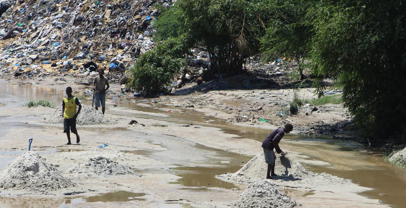
Figure 1: Illegal Municipal Solid Waste piles in the Msimbazi River Delta are causing regular flooding after heavy rainfall and contributing to environmental pollution. © Wikipedia Commons
Unmanned Aerial Vehicles (UAVs) for MSW Dumpsite Detection
Accurate knowledge of the location of MSW, including illegal dumpsites, is crucial for optimizing waste disposal and recycling efforts. The integration of UAVs with pre-trained neural networks for object detection presents a promising solution for mapping waste distribution in urban areas. UAVs offer high-resolution aerial imagery that surpasses the resolution of openly accessible satellite data, enabling the identification of both large and small waste piles with greater precision.
Case Study: Dar es Salaam, Tanzania
A team of geoinformatics researchers from the University of Heidelberg and HeiGIT, in collaboration with OpenData Development Tanzania, proposed a workflow utilizing UAVs to monitor Municipal Solid Waste (MSW). This workflow was tested in Dar es Salaam, Tanzania, with a specific focus on the Msimbazi River area, one of the most polluted riverbeds in eastern Africa. Dar es Salaam, home to approximately 5.3 million people, has around 27% of its population residing in the wider Msimbazi delta.
This region was chosen due to its significant contribution of waste to the Indian Ocean and its frequent flooding, exacerbated by clogged drainage systems caused by MSW. The research team trained an object detection algorithm on UAV imagery for MSW detection, which can be downloaded and fine-tuned for application in other areas (cf. UAV-Assisted Municipal Solid Waste Monitoring for Informed Disposal Decisions [Research Data] ). The model was evaluated using a crowdsourced, locally labeled MSW dataset to leverage regional expertise. The trained model achieved an F1-score of 0.92 for 1,289 MSW instance, indicating high accuracy.
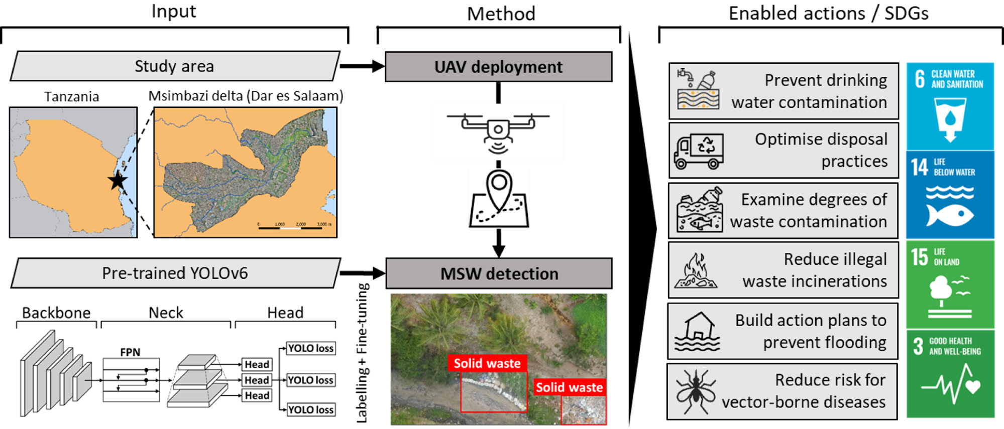
Figure 2: Workflow of harnessing commercial UAV technology to support MSW management.
Discussion of the Proposed Workflow for MSW Detection Using UAV Imagery
While the proposed workflow for MSW detection using UAV imagery has demonstrated promising results, several challenges remain that could be addressed in future studies. One major challenge is the indistinct and ambiguous boundaries that characterize MSW piles, complicating the accuracy of object detection. Enhancements could likely be achieved by applying image classification or segmentation techniques to small UAV imagery tiles to improve detection accuracy. Common False Positives (FP) in the object detection on MSW piles included “reflections in water” and “drying clothes”, while typical True Negatives (TN) referred to “rubble piles” and “courtyard mosaics”.
To improve model performance, the four object classes could be incorporated into the labeling process as separate categories. Indoor MSW or MSW beneath tree canopies and shelters was completely missed by the proposed method (Figure 3). A comparative study with openly accessible satellite imagery highlighted the importance of high-resolution UAV imagery for precise MSW mapping (Figure 4). However, satellite imagery could still be useful for large-scale assessments prior to planning more targeted UAV missions, which are often associated with higher labor costs and regulatory constraints. When applying the pre-trained model on UAV imagery in different contexts, cultural factors related to waste should be considered. For instance, in some regions, discarded car tires serve a functional purpose, while in others, they are classified as waste. This emphasizes the value of crowdsourced labeling tools such as MapSwipe, which enable local communities to contribute their knowledge to the labeling process, ensuring greater accuracy.
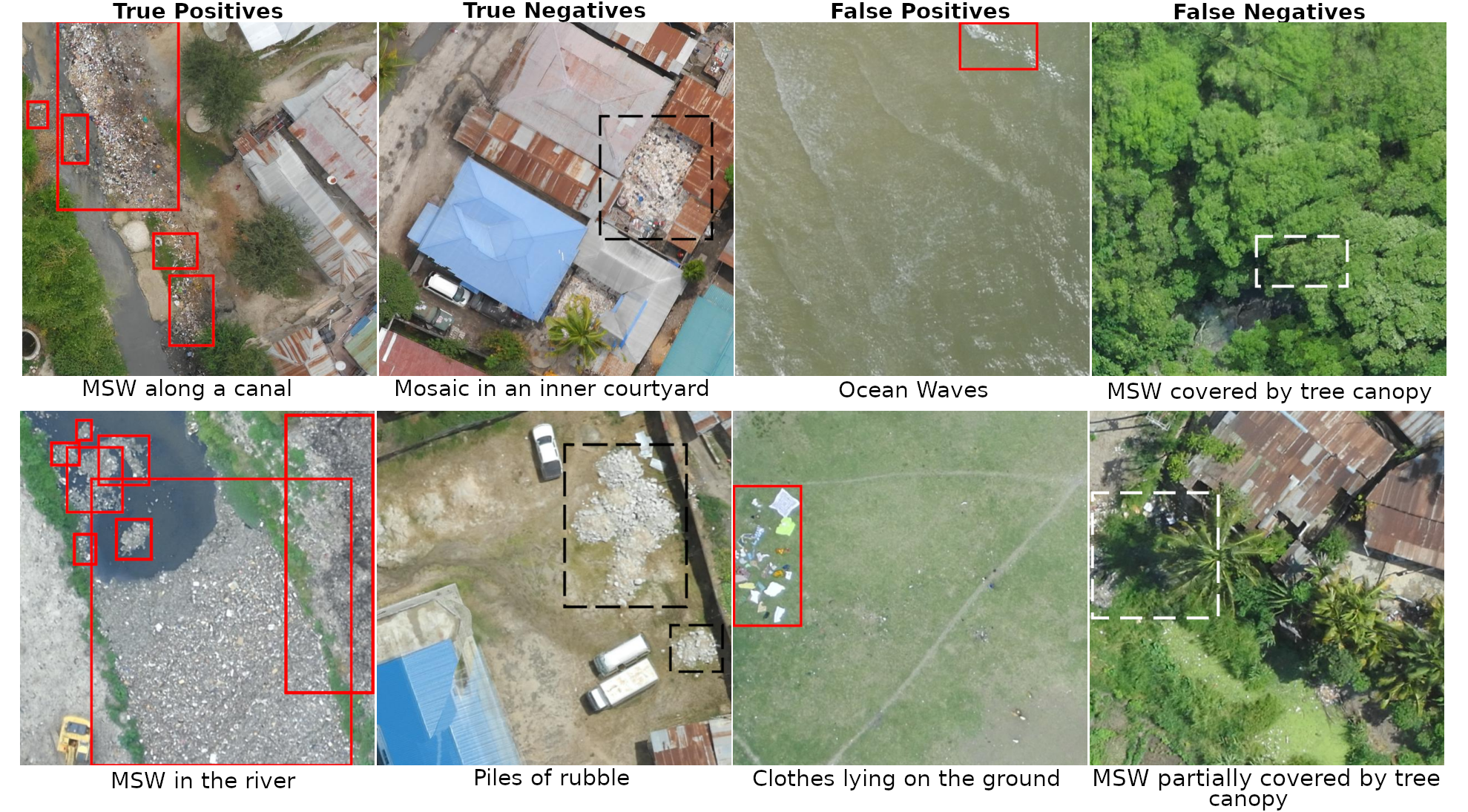
Figure 3: Examples of True Positives, True Negatives, False Positives, and False Negatives predicted by the proposed model. Detected waste piles were indicated by red bounding boxes.
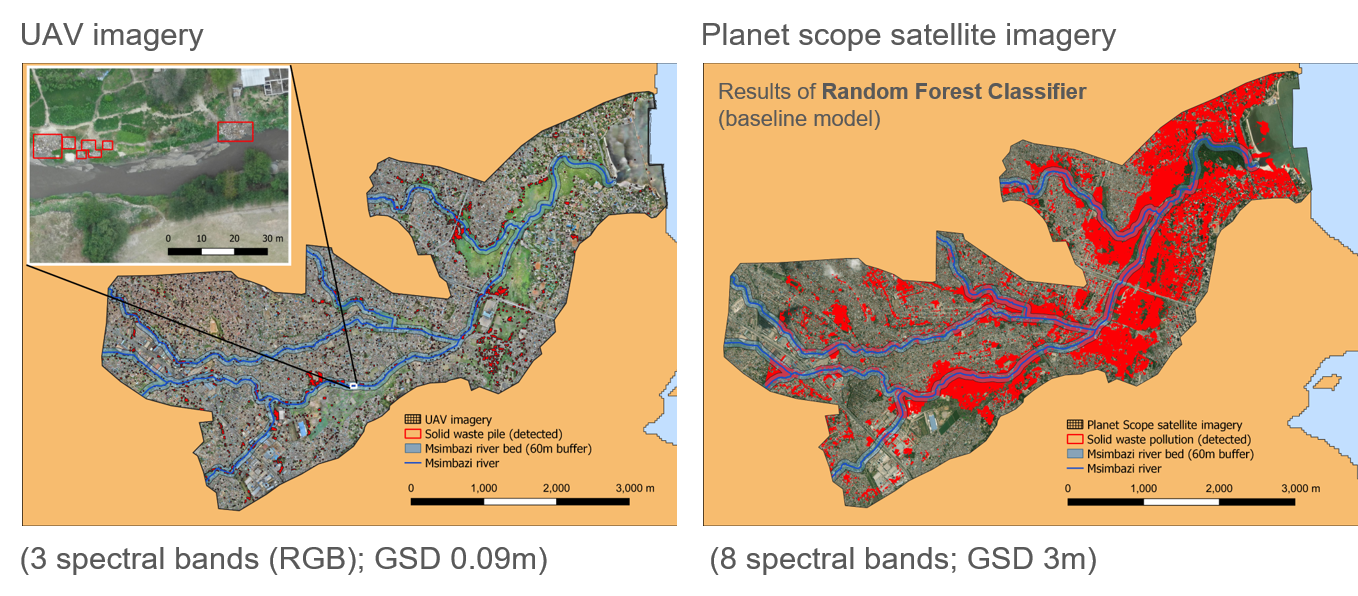
Figure 4: Left – Detected MSW piles along the Msimbazi delta in Dar es Salaam. Right – Satellite imagery based MSW pile detections for the Msimbazi delta utilizing UAV imagery based MSW detections as training and testing labels for rough evaluation of satellite imagery as a useful tool to map MSW piles.
By publishing the pre-trained MSW detection model (cf. UAV-Assisted Municipal Solid Waste Monitoring for Informed Disposal Decisions [Research Data] ), organizations such as OpenMap Development Tanzania (OMDTZ) can support local MSW management in Dar es Salaam, Tanzania, without relying on costly software. OMDTZ can regularly collect UAV imagery and apply the pre-trained MSW detection algorithms to generate up-to-date MSW contamination maps.
These maps can guide municipal decision-making, helping to prioritize waste collection efforts and identify optimal locations for establishing new official dumpsites that adhere to environmental regulations, ultimately reducing risks related to flooding and disease outbreaks.
This article was guest written by Steffen Knoblauch (Heidelberg University), Levi Szamek (Heidelberg University & HeiGIT), and Lisa Shkredova (HeiGIT).
Did you like the article? Read more and subscribe to our monthly newsletter!
#Contributing Writers

Next article


We are thrilled to announce that Geoawesome is expanding its collaboration with Montgomery Group, the organizers of Geo Connect Asia (GCA).
Building on the success of last year’s partnership, where we covered the event as official media partners and launched the Asian Leadership Series, we’re taking things to greater heights in 2025!
For the first time ever, Geoawesome is directly involved in shaping a conference agenda. At this year’s Geo Connect Asia 2025, we’ll be debuting the APAC Earth Observation (EO) Forum— a dedicated platform exploring the future of EO in Asia.
Rupert Owen on the partnership with Geoawesome – “I am delighted to be working with Geoawesome in broadening the reach, understanding and potential of geospatial based solutions in new markets. The true value of partnership is in exploring new ways of building communities through co-operation and establishing new platforms, starting with the launch APAC EO Forum this year. We value the expertise and drive that Geoawesome brings to Geo Connect Asia and especially welcome partners who can bring alive conversations in tune with the ambitions of the communities we are embracing.”
Introducing the APAC EO Forum
Scheduled for April 10, 2025, the APAC EO Forum will be one of several co-located events at Geo Connect Asia 2025, alongside Digital Construction Asia, Drones & Uncrewed Asia, and Marine & Hydro Asia. This forum will bring together industry leaders, researchers, startups, and policymakers to discuss how EO technologies are transforming industries, including insurance, climate resilience, disaster response, and sustainable development.
Key Highlights
- Expert-led panel discussions and keynotes from leading EO professionals
Real-world case studies showcasing the impact of EO across multiple sectors
Networking opportunities with key industry stakeholders
Members of the Geoawesome team, Muthu and Aleks, will be attending in person and look forward to connecting with geospatial professionals from across the region.

Exclusive Discount for Geoawesome Readers
We are delighted to offer our readers a exclusive 15% discount on a 2 Days Conference Pass for Geo Connect Asia 2025. If you are interested in attending, make sure to secure your spot soon.
Register here: Geo Connect Asia Registration
Sponsorship & Speaking Opportunities
A limited number of sponsorship and sponsored speaking opportunities are still available. Are you looking to position your brand at the forefront of the geospatial and Earth Observation industry? Then this is an excellent opportunity to engage with a highly relevant audience.
For event and media inquiries, please contact:
Rupert Owen
Co-founder & Director, Montgomery Group
Rupert.Owen@montgomerygroup.com
We look forward to welcoming you to Geo Connect Asia 2025 and delving into insightful discussions at the APAC Earth Observation Forum.

