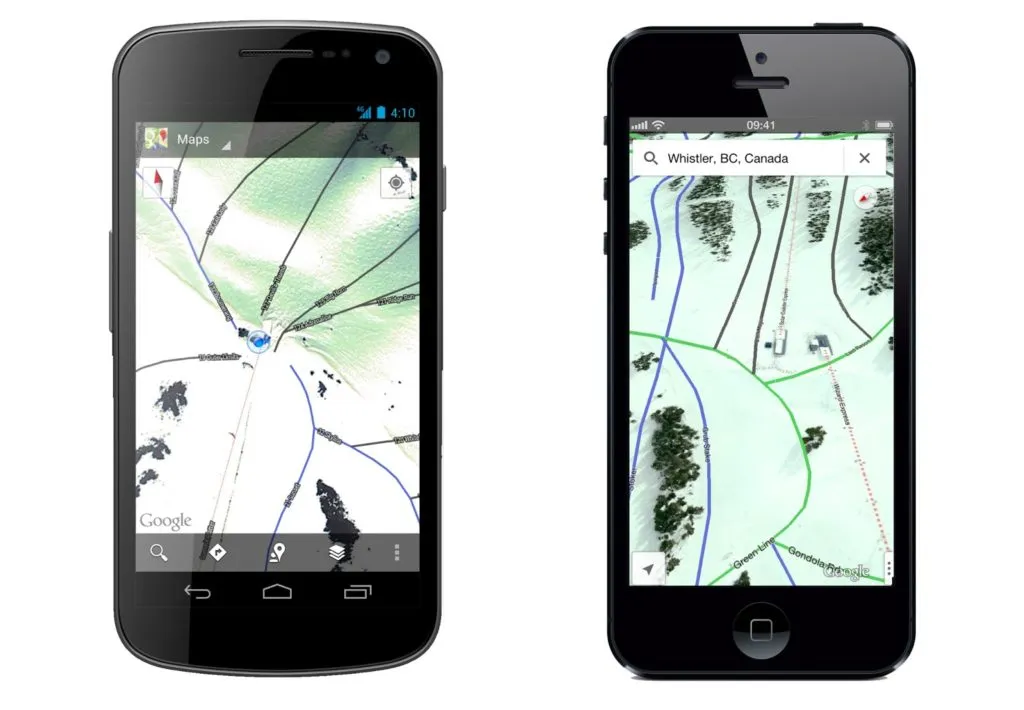

Those who have met me personally know that it’s a great news for me as I’m a total skiing freak. The Google Maps mobile app just got trail maps for 38 ski mountains in the U.S. and Canada. Even though I live in Europe it still makes me smile as it shows the trend. Google team please do a similar project in Europe!!!
Both Android and iPhone users will get precise maps of slopes with routes and ski lifts. Selected slopes are also available in Street View mode. It can be especially useful in a resorts and mountains that you’re visiting however it will not bring any value to freeride skiers. It seems that the routes are topologically linked together to some extend. Does it mean that we will see in a near future slope navigation? Personally I don’t see such a need, when you are on the top of the mountain, there is only one direction: down;).

Here you have the full list of slope maps now available:
|
|
Hopefully it will expand fast.

#Ideas

Next article
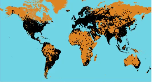

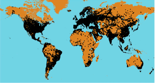
Cellular telephone coverage based on data collected by users of an Android
application from September 2009 to August 2012 (data provided by opensignal.com)
Cellular phones or Mobile phones have become indispensable in todays age and society. SMS and Mobile Internet made them tools of social networking and information sharing.
Cell phones went scientific with Smart phones becoming sensors for crowd sourcing of environmental data.
Now Imagine Cell phone towers acting as rainfall gauges! A team of researchers from the Royal Netherlands Meteorological Institute and Wageningen University, Netherlands have published a paper – ” Country-wide rainfall maps from cellular communication networks” on using cell phone signals to build rainfall maps.
We all know that Network operators use microwaves to link cellular towers & mobile phones together. When it rains, the signal received at the next tower down the line are weakened by reflection off raindrops. A phenomenon that is referred to as rainfall induced attenuation.
How is this going to help?
The answer lies in the abstract of the paper. From the abstract “Accurate and timely surface precipitation measurements are crucial for water resources management, agriculture, weather prediction, climate research, as well as ground validation of satellite-based precipitation estimates. However, the majority of the land surface of the earth lacks such data, and in many parts of the world the density of surface precipitation gauging networks is even rapidly declining.”
The technique is to record the signal strength of microwave transmissions of each cellular tower from the neighboring tower. Since the distance and signal strength at the transmitting tower are known, it can be easily modeled and any difference in signal strength is a pretty good indicator of attenuation.
Using data provided by T-Mobile, Aart Overeem and his team have developed an algorithm to measure the differences and predict the rainfall level.
In the paper, one can see that the team succeeded in their efforts. They mapped rainfall between June and September 2011 and found that readings derived from cell phone tower data tended to agree with those from the traditional rainfall gauges and radar.
This could really solve the power of having accurate measure of rainfall in different parts of the world. WIth decreasing number of rainfall gauges, meteorologists across the world were having issues predicting and quantifying rainfall in remote locations and locations that were in between 2 rainfall gauges. This innovative idea can help solve that issue and help measure rainfall with much better accuracy.
Cell Phone Towers are the new age rainfall gauges.

