Google DeepMind’s AlphaEarth Pushes GeoAI to New Frontiers in Planetary Mapping

Google’s new Google Earth AI initiative, which I recently covered here, is a major step forward in making geospatial AI practical for business, government, and research. One of its most powerful components is AlphaEarth Foundations – an AI model from Google DeepMind that works like a “virtual satellite” for the entire planet.
In simple terms, AlphaEarth takes in massive amounts of data from satellites, radar, climate sensors, and elevation maps, then blends it all into one consistent, ready-to-use digital map of Earth. Instead of having to collect, clean, and combine data from many different sources yourself, you get a unified, highly detailed, and regularly updated view of the planet – already analyzed and ready to integrate into your work. For businesses, this could mean faster insights, lower costs, and fewer technical headaches when working with Earth observation data.
What is AlphaEarth Foundations?
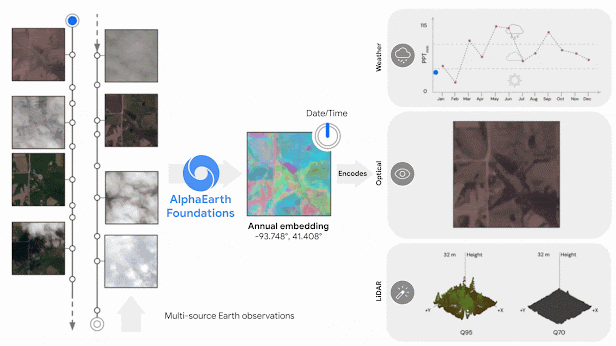
AlphaEarth is essentially an AI-generated digital twin of Earth’s surface. It ingests a wide variety of data – optical satellite imagery, radar scans, LiDAR-based elevation models, climate readings, and more – and compresses it into a single representation (“embedding”) that computers can easily analyze.
The model divides the planet into 10×10 meter cells, each containing a compact summary of what’s there, updated annually (with the potential for more frequent updates). This solves two persistent problems in geospatial analytics:
-
Data overload: Too much raw imagery and sensor data can overwhelm organizations.
-
Data inconsistency: Neighboring areas might be mapped at different resolutions or at different times, making comparison difficult.
AlphaEarth’s approach automatically fuses and standardizes the data, creating a consistent, apples-to-apples view of the planet. It also stores information 16× more efficiently than comparable systems, making large-scale analysis more affordable.
Benchmark tests showed AlphaEarth to be the most accurate among AI mapping systems tested, with 24% lower error rates on average – even when trained with limited labeled data. Over 50 pilot partners, including the UN FAO and Stanford, reported that it required significantly less human input while producing more accurate results.
From Petabytes to Practical Insights
AlphaEarth is already being made partially available through Google Earth Engine as an annual global dataset. Early uses include:
-
Mapping uncharted ecosystems – helping conservation projects classify and prioritize restoration efforts.
-
Agriculture and land use monitoring – enabling near real-time tracking of deforestation and crop changes.
-
Urban and infrastructure planning – providing cloud-free, consistent mapping for planners and developers anywhere in the world.
Google has also hinted at pairing AlphaEarth with its Gemini AI reasoning engine, which could allow analysts to ask complex “where and why” questions in plain language and get detailed, data-backed reports.
Why This Matters for Enterprises and Investors
For enterprises, AlphaEarth is a geospatial foundation model – a ready-made intelligence layer to build new applications on. Much like how large language models underpin many AI text tools, AlphaEarth could power a new generation of location-based analytics in insurance, agriculture, forestry, finance, and beyond.
Key benefits for organizations include:
-
Faster go-to-market for geospatial products (no need to build your own global AI model).
-
Lower skill barrier – deep geospatial expertise is baked into the model.
-
Scalability – consistent global coverage means solutions can be deployed anywhere without major re-engineering.
The result could be a democratization of geospatial intelligence, where even small agencies or consultancies can access analysis quality that previously required large research teams.
Of course, challenges remain: organizations will need to understand the model’s outputs, address potential AI “black box” concerns, and integrate results into existing systems. Still, with its combination of scale, consistency, and efficiency, AlphaEarth is poised to become a central asset in the emerging GeoAI ecosystem.
Bottom line
AlphaEarth Foundations, as part of Google Earth AI, is more than a research breakthrough – it’s a practical tool that could redefine how businesses, governments, and NGOs map, monitor, and make decisions about our changing planet.
Did you like the article? Subscribe to our monthly newsletter!


#GeoAI

Next article

AI is advancing at an unprecedented rate, and its transformative power is reshaping nearly every sector, including our own. From predictive analytics to automated feature extraction, Artificial Intelligence is fundamentally changing how we collect, process, and understand geospatial data.
For many, the constant influx of news about these technological breakthroughs can feel overwhelming. The desire for a deeper understanding and expert-led discussion on the topic has never been greater.
That’s why Geoawesome is thrilled to announce a new series of digital events designed to help our community navigate this exciting landscape. Starting in September, this five-part series will bring together leading experts to deep-dive into the critical topics defining the future of AI & Geospatial (or GeoAI, if you prefer).
Each one-hour event will focus on a different, cutting-edge topic, featuring a presentation followed by an interactive Q&A session. To foster a collaborative environment, we will also organize breakout rooms at the end of each session for you to network, exchange ideas, and document your questions for future events.
This series is made possible with the generous support of our friends at Kili Technology, who share our passion for fostering trusted information and innovation in the geospatial industry.
Join us as we explore:
- Foundational Models: The new building blocks for GeoAI. (Monday 29th September, 2025)
- AI & Geospatial in the Financial Sector: The impact of AI on corporate reporting, ESG, and investment. (Watch the full webinar on demand)
- Integrity, Trust, and Provenance: Ensuring the reliability and ethics of AI-driven geospatial data. (Monday 13th October, 2025)
- Collaboration & GeoAI for Good: Leveraging GeoAI for humanitarian and environmental applications. (Monday 3rd November, 2025)
- State of the Industry: A look at the key trends and future direction of GeoAI. (Monday 1st December, 2025)
Do you have expertise in one of these areas and are interested in speaking? Or do you have specific questions you’d like to see addressed? Please reach out to muthu@geoawesome.com.
We hope to see you there! To stay informed about registration links and new details as they are released, be sure to sign up for our newsletter.
Further reading

