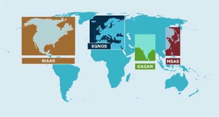
The GPS aided geo-augmented navigation (GAGAN), jointly developed by the Indian Space Research Organization and the Airports Authority of India (AAI) is now operational and can be used by the aviation industry. The Directorate General of Civil Aviation (DGCA) in India certified GAGAN for use on the 30th of December, 2013 (Source: The Hindu).
What does this mean?
Although GAGAN signals were available for few months now, the corrections that were being sent by the system was considered not fit for safety-of-life operations i.e. for aircraft navigation, etc. With the DGCA certifying GAGAN, one could use the SBAS corrections with full confidence.
All aircrafts flying over the Indian airspace and adjacent areas will be able to make use of the SBAS corrections. The availability of GAGAN in fully operational mode will help bridge the gap between the European and Japanese SBAS services EGNOS and MSAS respectively. For the civil aviation industry this means increased fuel savings (thanks to much more accurate navigation), improved vertical guidance at runways, fewer ground aids for take-off and landing which reduces the workload of flight crew and the Air traffic controllers.
On a personal level, if you have a SBAS capable GNSS receiver, you can easily use the SBAS services from GAGAN by setting your SBAS channel in the receiver to track PRN 127 and 128 provided the receiver is near the coverage area. (more information: SBAS fundamentals)
An update on the Indian Regional Navigation Satellite System (IRNSS): ISRO is set to launch IRNSS-1B, IRNSS-1C and IRNSS-1D later this year. ISRO had already IRNSS-1A last year. IRNSS a constellation of 7 satellites, will function as a regional navigation system and is expected to be operational by 2016.


