#Business #Ideas

Foursquare Shows Completely Fresh Approach And It Directly Competes With Yelp

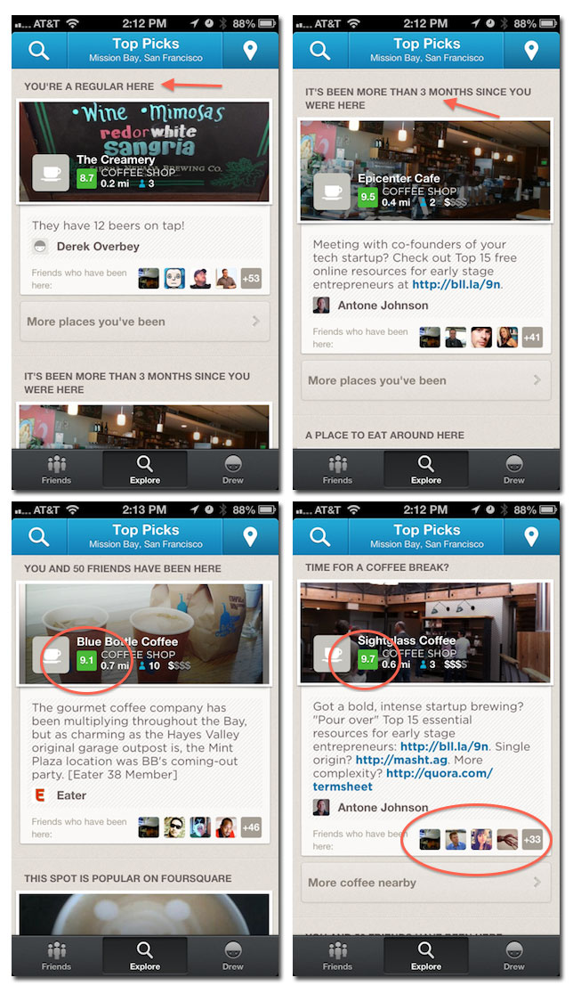
Last week Foursquare launched some new features making a better use of billions of checkins collected over the years. It shows you a list of places to go based on where you and your friends actually like to go. Until now, the Explore tab in the app sent you to a mix of places suggested by friends and their actions, along with what was close by. Now, there is a heavy focus on the places you’ve been to, but haven’t been back to in a while. It also adds a rating system between 1-10 based on interesting information everyone has pumped into the system.

Actually now 4sq directly enters the territory of Yelp. Basically it was Yelp’s model and apparently 4sq noticed some probability it that approach. Over the past few months, Foursquare has been working to become more of a local search engine than just a check-in social network.They have started with launching the ‘Explore’ feature, and then opening it to the even non-4sq users.

But actually the Yelp is not sleeping. In August they ‘ve started the new feature including a news feed of sorts that shows friends’ activity on the site, including comments, check-ins, photos, and tips. They’ve also added in-app menus. The competition is always good… as it’s the best motivator for the development. Foursquare is surely looking for new areas to monetize their business. Although Foursquare is worth over $700 million according to their fourth round valuation, they’re business model is not sustainable. Yelp is worth twice as much, and I would look here for a source of  Fousquare’s decision to go into this direction.

source: Techcrunch

Say thanks for this article (0)
The community is supported by:
Become a sponsor
#Business
#Business #Events
SatSummit 2024 Reflections: The evolving landscape of Earth Observation
Avatar for Florian Fichtner
Florian Fichtner 05.22.2024
AWESOME 9
#Business #Featured
Introducing Planet Insights Platform: Easier, Faster, and More Cost-Effective Insights
Avatar for Sponsored Article
Sponsored Article 06.14.2024
AWESOME 1
#Business #Featured
Call for nominations: Global Top 100 Geospatial Companies 2025 Edition
Avatar for Muthukumar Kumar
Muthukumar Kumar 10.1.2024
AWESOME 1
Next article
#Business #Ideas

Create, Edit and Visualize GIS Data From Within the Google Earth Environment with GRGlobe

GRGlobe is an awesome new app for GeoGeeks from the Science Applications International Corporation (SAIC) . It is a  commercial software solution to create, edit, and visualize GIS data natively within  a Google Earth environment.  Intended uses and users of GRGlobe include: government, defense, emergency response, law enforcement, energy, environmental, utility, education, land management, forestry.

According to SAIC, the features provides the following capabilities to users:

  •  Create, edit, and visualize GIS data natively on the Google Earth plug-in
  • Display data as organized GIS layers and view via a table of contents
  • Categorize feature data and visualize unique themed symbology based upon feature attributes
  • Open layer attribute table to select one or more features and view associated information
  • Edit feature attribute data
    • Attribute editing tool allows for layer editing and adding new attribute fields
    • Attach one or more linked files from multiple data formats (or folders) to any point, line, or polygon feature
  • Query attributes to locate feature data
  • Support for common coordinate systems and formats (DD, DM, DMS, UTM, MGRS, XY, and WKT)
  • Provide structure to data that enables GIS functionality
  • Easily import points, lines, or polygons from coordinates in multiple file formats:
    • KML
    • Esri® ArcGIS® shapefile and geodatabase (personal, file, enterprise ArcSDE®) data
    • Excel spreadsheet
    • Database (Access®, Oracle®, SQL® Server, etc.)
    • Delimited text
    • Semi-structured copy/pasted text
  • Export wizard creates products from specified layers and attribute data into popular formats:
    • Microsoft PowerPoint®
    • KML
    • GIS data (shapefile, geodatabase)
    • Excel® spreadsheet
    • Delimited text
  • Create, edit, and delete points, lines, and polygons with interactive point-and-click and coordinate-based tools
  • Add data from popular formats including:
    • Shapefile and feature class
    • KML data
    • Georeferenced raster data

And the benefits includes:

  • Combine and share data between multiple platforms
  • Fast, flexible interface
  • Quickly create, edit, import, and export data
  • Leverage your existing enterprise globe server for map and layer display
  • Create complete PowerPoint presentations from data layers and associated attributes, including imagery
  • Familiar interfaces and workflows designed from existing GeoRover software products

You can get a free trial version here and try it out now. Enjoy!

Source: blog.gisuser.com and www.saic.com

Read on
Search