Location Based Services : Expected Trends and Technological Advancements
Location data is a vital part of the mobile experience and enables some of the most widely used mobile apps, which can be used for geo-social networking, navigation and travel, retail and real estate searches, and mobile marketing and advertising. Whether used for locating friends in the area, finding the nearest restaurant or advertising deals to shoppers who are in the neighbourhood, location-based services (LBS) grant users access to relevant, up-to-date information about their surroundings and allow businesses to provide current updates to their customers. All these features offer a dynamic user experience, providing a new level of convenience that changes the way businesses interact with customers and other enterprises.
How it evolved?
The first two stages in the evolution of commercial location services have been location enhanced applications (such as local information like closest pizza) and location-based applications (such as navigation) in which location is intrinsic to the application. In former, location arguably makes the application better (but it could stand by itself) and the latter represents applications that only make sense with location. The advancement in Hybrid location technologies had brought about major improvements in accuracy, reliability and the services that can be delivered. Due to these advances, LBS were increasingly being deployed in mission-critical applications such as guiding emergency services directly to a caller.
Past trends and statistics through which the LBS travelled
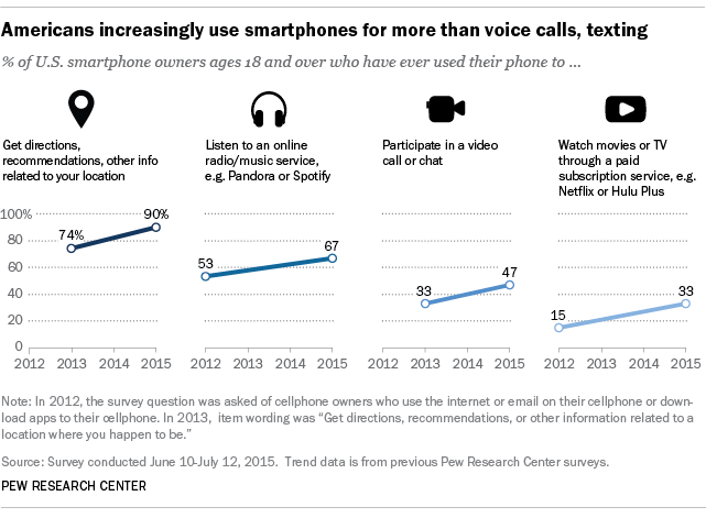
Among the smartphone activities measured, getting location-based information is the most universal task. Nine-in-ten smartphone owners use their phone to get directions, recommendations or other information related to their location, up from 74% in 2013.
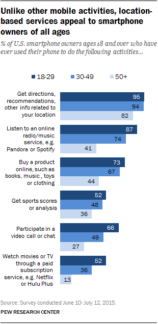
 Younger adults are especially likely to reach for their phone for something other than calling and texting. Getting location-based information is the one activity measured that is common across all age groups, however.
Realizing the technological future of LBS
In terms of technology the demand is for Indoor LBS and vertical positioning. A lot of startups are working on this area by the fusion of wireless sensors, geo-magnetic field and beacons which will be complementing the GPS.
Usage and application of the LBS will experience a major shift, creating a better environment empowered by Artificial Intelligence. Driverless cars enhanced with LBS and AI will create a huge impact on transportation infrastructure. Augmented reality is yet another arena where the real and the virtual world are combined to deliver a broad range of application. The relevancy of such applications will be highly dependent on the location data.
The future may also experience the integration of Indoor and Outdoor LBS, which will facilitate a seamless M2M (machine to machine) communication. A wild imagination would be your car’s LBS communication with the heater at home and turning it on 10 minutes before you reach home to create a suitable environment when you reach home. Emergency cases, rescue operation and disaster management will receive limelight LBS in near future.
Status of locational privacy
All the location based applications to become a reality will force on compromising one’s privacy. Asif Khan, Founder & President LBMA at the Location World Confernce, Hydrebad highlighted that 6 years ago only 12-15% of the people at USA were comfortable with sharing the location data and now in 2017 it has increased to 60% . The reason for giving up on privacy is attributed to the relevancy of the information associated with LBS.
An infographic, made from the extensive research conducted by Skyhook found that 83% percent of app users say location is crucial to their app experiences, but nearly 40% are hesitant to share their location.
The investments on location based marketing and services in 2017
According LBMA 2017 Global Location Trends Report, in a survey of “500 marketing decision makers,” 25% of marketing budgets are spent on location-based marketing and over 50% of brands are using location data to target customers. This represents billions of dollars. Location is an increasingly critical element of digital marketing for brands and enterprises. The key findings of the report is as follows:
– Company usage of location-based marketing is on the rise in most countries € 5 percent increase in the US from 2016 to 2017, 6 percent in Canada, 7 percent in the UK, and 3 percent in Singapore. Only Germany saw a 3 percent decrease in location-based marketing usage.
– Executives agree LBM is an important business issue and its importance will increase in 2017.
– Social Location Services and Location Based Advertising were the top areas of interest in 2016 and will continue to be so in 2017.
– Location-Based technology will increasingly be used for customer service and other non-marketing initiatives.
Trends and statistics of LBS in future
A report by technavio highlights that the LBS market will witness tremendous growth and will post a staggering CAGR (Compound annual Growth rate) of more than 43% in 2020. The number of deployments of local area networks and home area networks such as Wi-Fi and WLAN has been increasing globally, which is one the significant factors driving this market’s growth. The adoption of VPNs by business organizations enables them to provide indoor LBS on their premises.
The increasing popularity of cloud-based big data analytics is one of the upcoming trends gaining traction in the market. Big data analytics provide enriching insights on consumer buying patterns so that the retailers can increase their sales volume and enhance customer search experiences. Location-as-a-Service companies, such as GeoSpice, use big data analytics to offer cloud-based web services and mobile LBS, which can integrate real-time location information and data analytics.
The past analysis shows that the retail companies have dominated the Indoor LBS than other segments such as hospitals, airport, government agencies, public security and etc., Indoor LBS providers offer coupons and discounts through push and pull marketing technologies. These services also provide social information such as ratings and reviews, product videos, and recommended products, thereby improving the overall shopping experience. Additionally, location-based marketing is extensively used across different industries to send product or service promotional messages based on user location. Many companies use location-based apps for targeted advertisements to reach potential consumers in real time, which will aid in this segment’s growth over the next four years.
It’s just the beginning of the AI with LBS odyssey!


