Why Orthorectification is Key for Real-World Terrain Mapping and How To Use It

Editor’s note: This article was written as part of EO Hub – a journalistic collaboration between UP42 and Geoawesome. Created for policymakers, decision-makers, geospatial experts and enthusiasts alike, EO Hub is a key resource for anyone trying to understand how Earth observation is transforming our world. Read more about EO Hub here.
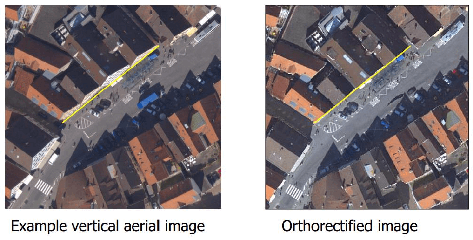
Imagine you’ve taken a photo while standing at a slight angle. Everything would look slightly tilted and not quite as it appears in reality. Think of orthorectification as a process similar to straightening the picture.
In the geospatial realm, orthorectification ensures that everything is accurately represented. Just as you would straighten your photo, orthorectification corrects distortions so that every point in the image corresponds precisely to its real-world location.
In this article, we’ll take a closer look at the reasons why orthorectification is so key to real-world terrain mapping: what is it, why does it matter, and how can you use it?
What is Orthorectification?
Orthorectification is an essential process in creating accurate maps of the planet’s surface.
It corrects distortions in satellite and aerial imagery that are caused by a myriad of factors, such as the angle of the camera (sensor tilt), variations in terrain elevation, and the curvature of the Earth.
Orthorectification acts like a digital straightening tool—it adjusts the image so that everything is correctly aligned, as though the image was taken directly from above (at nadir).
What causes distortions in imagery?
All remotely sensed images of Earth contain a level of geometric distortion. These are inherent in the acquisition geometry, determined by the design of the observing unit and of the observed unit.
Usually, distortions are seen to arise from:
- The observing unit or “observer” – e.g. sensor tilt, the motion of the platform, etc.
- The observed object or “observed” – e.g. the Earth’s surface, rotation, atmosphere, etc.
In general, we see more pronounced distortions in aerial imagery when compared to satellite platforms, which operate from relatively stable orbits and higher altitudes. Either way, removing or reducing image distortions is important before using the imagery to make measurements, create maps, or extract information.
How Does Orthorectification Work?
Orthorectification of an image is a pretty mathematically rigorous transformation of an original image into an orthogonal projection, complete with the elimination of distortions. Orthogonal projections then provide us with the ability and opportunity to create orthophoto images, orthophoto maps, orthophotoplans, and other orthorectified images and products.
To achieve this, orthorectification uses the following inputs:
- Digital Elevation Models (DEMs): These are representations of terrain elevations that help to correct for height variations.
- Rational Polynomial Coefficients (RPCs): These mathematical models describe the relationship between image pixels and geographic coordinates, guiding how to adjust the image.
- Ground Control Points (GCPs): These are known locations on the ground with precise coordinates that improve accuracy during the correction process.
In addition to the above, it’s important to have an awareness of the distortions present in imagery. Understanding distortions such as sensor tilt, when the camera isn’t pointing straight down, and elevation variations, such as mountains or valleys, helps to know which features may be skewed or misrepresented.
Steps for Orthorectification
Now let’s walk through the steps to perform orthorectification:
- Gather Required Data
-
-
- Start by collecting all necessary data, including your datasets, raw satellite or aerial imagery, RPC files, a DEM, and any available GCPs. Having everything organized will make the process smoother.
-
- Select Software
-
-
- Choose GIS software that supports orthorectification processes. Popular options include ArcGIS or specialized tools like ERDAS Imagine. Each has its own strengths, so pick one that fits your project needs.
-
- Input Data
-
-
- Load your raw image into the software along with the RPC file and DEM. This step is where you set up everything for the correction process.
-
- Apply Orthorectification Algorithm
-
-
- Here’s the fun part! Apply orthorectification algorithms:
- For basic correction: if you’re working with just RPCs and a DEM, you can start by using these to adjust your image.
- For enhanced accuracy: if you have GCPs available, incorporate them into your correction process. This will significantly improve the accuracy of your final product.
-
- Validate Results
-
-
- Once you’ve applied corrections, it’s crucial to validate your results. Compare your orthorectified image against known reference images or datasets to ensure accuracy. This step helps catch any errors before you move forward.
-
- Export the Orthorectified Image
-
- Finally, when you’re satisfied with the corrections and validations, save your orthorectified image for further use in mapping or analysis. This image is now ready to be integrated into GIS applications or shared with stakeholders.

What is Real-World Terrain Mapping?
Terrain maps are graphical representations of the Earth’s surface. They depict the physical features of an area and use contour lines to illustrate changes in elevation and outline the shape and characteristics of the land.
From hills and valleys to water bodies and forests, terrain maps focus on the landscape’s shape and elevation. The wealth of information within terrain maps means they’re useful for navigation, urban planning, infrastructure, land use, and much more.
How Does Orthorectification Help with Real-world Terrain Mapping?
As we know now, the orthorectification of satellite and aerial imagery helps to piece together a more accurate picture of the planet. It is an essential step towards creating reliable maps and conducting precise measurements.
Here’s how orthorectification contributes to this:
- Correcting Distortions: This is crucial for creating reliable maps where features like roads, buildings, roofs, and natural landscapes are correctly positioned.
- Uniform Scale: One of the key benefits of orthorectification is that it provides a constant scale throughout the image. This means distances can be measured accurately without the need for field checks. For example, when helping urban planners assess land for development, they can rely on precise measurements from orthorectified images.
- Integration with GIS: This integration allows for the combination of various datasets, such as land use data or environmental information, enabling more comprehensive analyses and terrain map creation.
- Enhanced Visualization: Orthorectified images serve as effective background layers in GIS applications, providing a clear visual context for analysis results. This clarity helps users interpret complex spatial data more easily, making it valuable for decision-making processes in fields such as environmental monitoring and disaster management.
- Up-to-Date Data for Rapid Response: In situations like natural disasters, having up-to-date orthorectified imagery allows emergency responders to assess damage quickly and efficiently.
- Precision in Environmental Monitoring: Orthorectified images are essential for tracking changes in land cover, deforestation, and other ecological phenomena with high precision.
In general, orthorectification not only enhances visual clarity but also ensures that measurements taken from these images are precise and useful for various real-world applications.
How Can We Use Orthorectification?
Use cases: Orthoimagery Applications
Orthorectified imagery has an incredibly wide range of applications, from precision agriculture and urban planning to disaster response and environmental monitoring. Its versatile nature makes it a useful resource across different sectors.
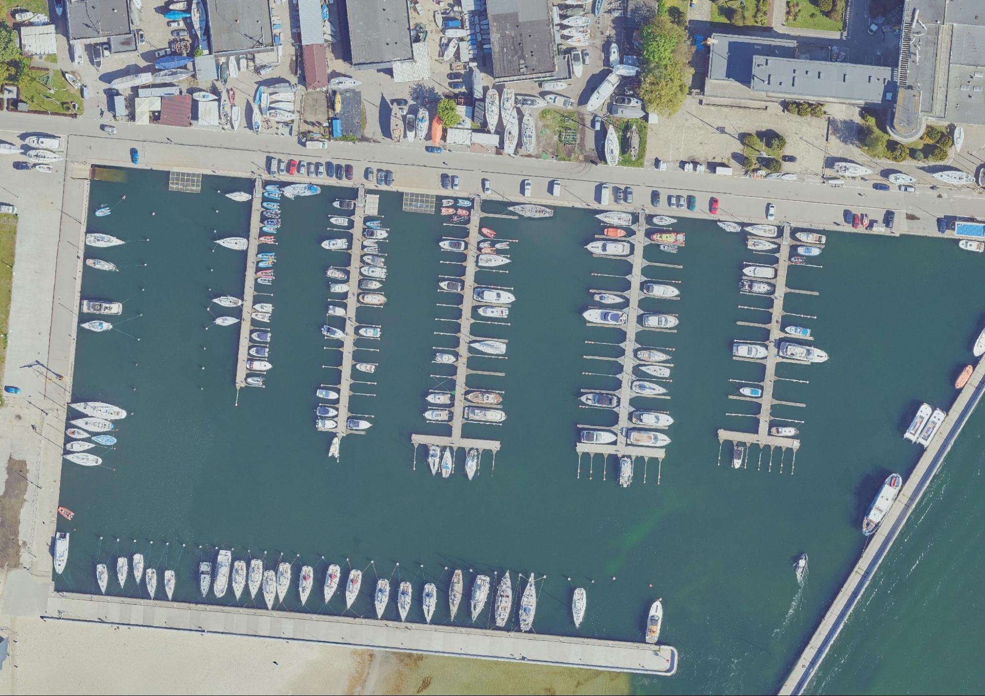
Below are some visuals illustrating the before and after effects of orthorectification. You can see the difference it makes when applied to use cases including vessel, shoreline, construction, and traffic monitoring.
Before and after images: Orthoimages vs. Orthorectified True Ortho
Orthorectification in urban areas corrects distortions, ensuring that buildings, roofs, and other objects appear in their true geographical positions. In the after image (visual below), it’s noticeable that the building’s roofs are in the correct position. This example comes from Żory city center in Poland.
Mapping parcels and elements within them ensures that property boundaries, buildings, and infrastructure are accurately represented in their true positions on the Earth’s surface. This precision allows for reliable measurements, with accuracy up to centimetres, and spatial analysis of the parcel’s components, such as building footprints, vegetation, and utility lines, without distortion or misalignment.
In this example, we’ve looked at Jasna Góra fortress in Częstochowa, Poland. When mapping high towers and fortresses, like here, orthorectification ensures that these tall and complex structures are accurately positioned on the map without distortion due to elevation or sensor angle.
In mapping industrial pipes and chimneys, orthorectification ensures that these tall and linear structures are accurately positioned in relation to the ground, correcting any distortions caused by their height or the angle of image capture. In this case is important to project the accurate position of these engineering facilities.
Vessels monitoring
Case study: Gdynia, Poland
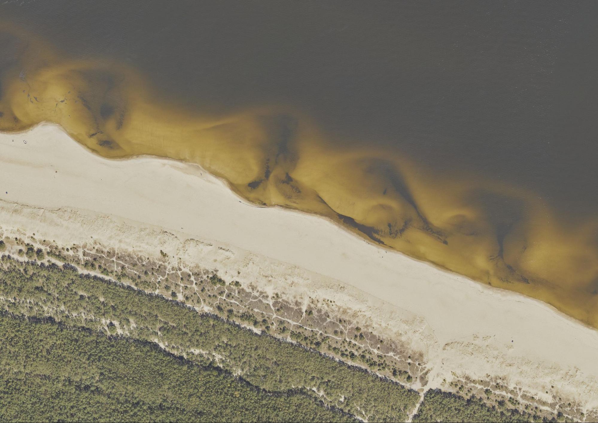
Shoreline monitoring:
Case study: Shoreline near Gdańsk, Poland
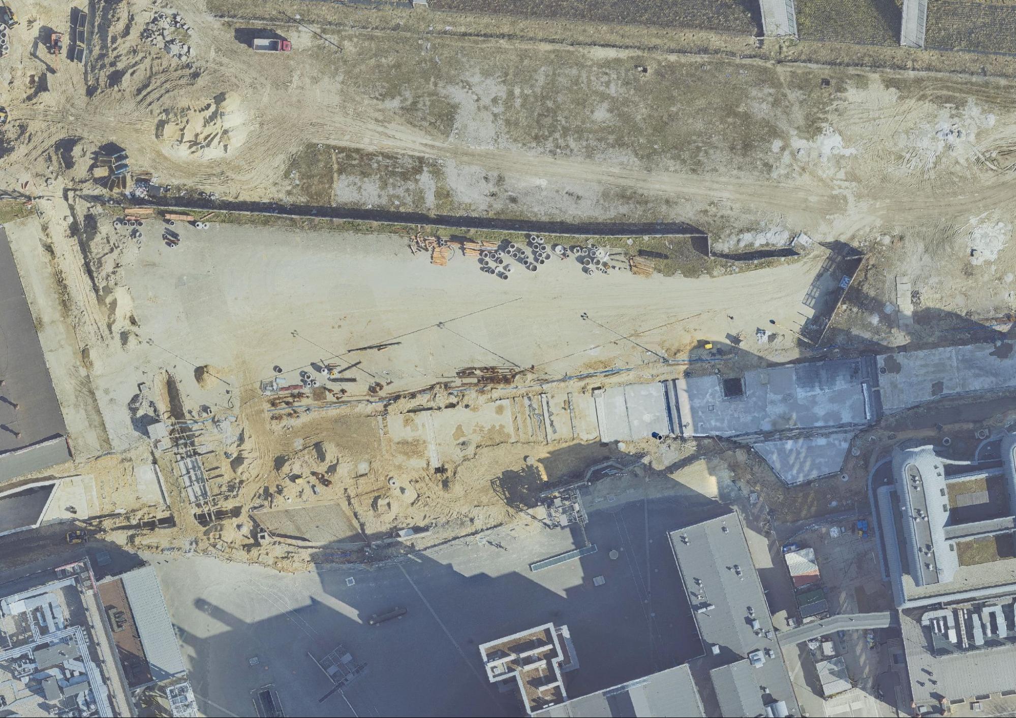
Construction monitoring:
Case study: Łódź, Poland
Car traffic monitoring:
Case study: Częstochowa, Poland
Orthoimages repository
In summary, orthorectification removes sensor/satellite motion and terrain-related geometric distortions to obtain map-suitable images. By correcting distortions, we ensure a uniform scale. This facilitates GIS integration and provides enhanced visualization.
Orthorectification plays a key role in effective real-world terrain mapping across various applications—from urban planning to environmental monitoring and disaster response.
Want to perform orthorectification yourself? Check out UP42’s practical guide.
Did you like the article? Read more and subscribe to our monthly newsletter!

#Categories
Next article
How Drone Data Helps to Monitor and Reverse Deforestation While Empowering Local Communities
Editor’s note: This article was written as part of EO Hub – a journalistic collaboration between UP42 and Geoawesome. Created for policymakers, decision-makers, geospatial experts and enthusiasts alike, EO Hub is a key resource for anyone trying to understand how Earth observation is transforming our world. Read more about EO Hub here.
Earth lost nearly a football pitch of carbon-absorbing rainforest every 5 seconds in 2022, according to the World Resources Institute (WRI). Deforestation has most acutely affected tropical rainforests, with 9.3 million hectares lost each year between 2015 and 2020—mostly due to human activities like agriculture, logging, and mining.
These alarming annual deforestation rates have severe impacts on biodiversity, greenhouse gas emissions, and local communities. It strips the livelihoods of many forest-dependent communities that rely on forests for shelter, income, and food.
How can technology support those impacted?
In this article, we’ll look at traditional and modern methods of monitoring deforestation, and how these can be utilized to reverse it and empower local communities in the process. Drones, specifically, have the potential to keep a close eye on forests, deforestation, and conservation efforts.
Why does deforestation happen?
Deforestation, the large-scale removal of forest areas, stands as one of the most pressing environmental challenges of our time.
Since 1990, over 420 million hectares of forest have been lost due to human activities. The devastating scale of deforestation is hard to comprehend. Approximately 2,400 trees are cut down each minute. Such a rapid rate of loss means that by 2030, there may be only 10% of the world’s rainforests left.
It sounds bleak and it is. As a society, we grapple with the balance between growth and sustainability.
So, why does deforestation happen? Where will we go from here?
Deforestation is primarily driven by activities that prioritize short-term economic gains over long-term ecological sustainability. At the forefront of these drivers is agricultural expansion, with vast tracts of forest being cleared to make way for cattle ranches and crop fields. This is in response to the ever-growing global demand for food and livestock products.
Alongside agriculture, the timber industry continues to exert significant pressure on forests worldwide. While not the primary cause, logging for timber and paper products still contributes to forest loss, with illegal logging a significant issue in areas of the Amazon, Central America, and Southeast Asia.
Wildfires, both natural and human-caused, can result in significant forest loss. 75% of tropical rainforests have lost the ability to properly recover from wildfires and drought.
Urbanization also plays a large role, as cities expand outward, encroaching upon forests to accommodate growing populations and infrastructure needs. The construction of roads, dams, and mines, as well as this urban expansion, contribute to around 15% of deforestation.
With urbanization expected to increase, how can we better protect our forests?
This complex interplay of economic, social, and demographic factors has resulted in a relentless assault on the world’s forests, threatening biodiversity, disrupting climate patterns, and jeopardizing the livelihoods of communities that depend on these ecosystems.
Grim findings from recent research indicate that the Amazon rainforest has now shifted from being a carbon sink to a net carbon source. This means it emits more carbon dioxide than it absorbs, releasing approximately 1 billion tonnes of CO2 per year.
This critical tipping point is a wake-up call for us all. It indicates the urgent need to reduce global emissions and protect the remaining forests.
What are the impacts of deforestation?
Deforestation has multifaceted impacts on the environment, biodiversity, climate, and society as a whole. Addressing these requires a combination of policy measures, sustainable practices, reforestation efforts, and community engagement:
- Loss of biodiversity: Forests are home to a vast array of plant and animal species. Deforestation destroys habitats and pushes many species towards extinction. 70% of the planet’s land animals and plants live in forests, and many cannot survive deforestation.
- Climate change: Forests act as carbon sinks. When destroyed, they release stored carbon dioxide into the atmosphere, contributing to global warming and becoming carbon sources (like the aforementioned Amazon). Deforestation accounts for about 10% of anthropogenic carbon emissions.
- Soil erosion and degradation: Soil has a unique relationship with the trees they support. Tree roots bind with and anchor to soil—maintaining soil integrity and providing stability. Without this protection due to deforestation, soil erodes quickly, leading to soil degradation.
- Disrupted water cycles: Forests play a crucial role in the water cycle through transpiration. A large tree can transpire up to 100 gallons (378 liters) of water per day. Deforestation alters rainfall patterns, potentially leading to droughts in some areas and flooding in others. For example, deforestation has been associated with a 25% decrease in rainfall in Texas. Meanwhile, in the Brazilian Amazon, deforested areas experience 4-5 more dry months per year compared to forested areas.
- Impact on indigenous communities: Many indigenous communities rely on forests for their livelihoods, food, and cultural practices. Deforestation threatens their way of life. For example, indigenous people occupy 404 million hectares in Latin America, with 237 million hectares in the Amazon Basin. Deforestation activities, such as farming, logging, and mining, encroach on these lands, displacing communities and disrupting their traditional ways of life.
- Increased risk of disease: Forest fragmentation due to deforestation can lead to greater contact between wildlife and humans, potentially increasing the risk of zoonotic disease transmission. A study in Nature found that forest fragmentation in Africa increased human exposure to the Ebola virus by 15%. Also, research shows that about 31% of emerging infectious disease events are linked to land-use changes, including deforestation.
- Economic losses: As well as the impacts on the environment, people, and biodiversity, the bottom line is also affected by deforestation. Although not as widely discussed, deforestation and forest degradation result in global economic losses of around $4.5 trillion a year, according to the World Bank.
Monitoring deforestation
Now that we’ve looked at why deforestation takes place and what the impacts are, let’s shift focus to what we can do about it. Monitoring deforestation is an important first step towards managing and mitigating it.
Traditional monitoring methods
Traditional deforestation monitoring methods typically relied on a combination of ground-based surveys, aerial photography, and manual interpretation of imagery. These approaches offered detailed, localized insights into forest composition and health but are often time-consuming and resource-intensive.
While still valuable, traditional methods often have limitations in scale and efficiency:
- Ground surveys:
- Involves field teams physically traversing forest areas to collect data
- Provides detailed, localized information on forest composition and health
- Limited in coverage and time-intensive
- Aerial photography:
- Uses aircraft to capture high-resolution images of forest areas
- Offers better coverage than ground surveys but is still limited in scale
- Requires significant resources for frequent monitoring
- Manual interpretation:
- Experts analyze images or field data to identify deforestation patterns
- Highly accurate but often time-consuming and subjective
Modern monitoring methods
Modern deforestation monitoring has evolved in recent years, thanks to the latest geospatial technologies and data analysis techniques. We can now detect, quantify, and respond to forest cover changes across vast areas with incredible temporal resolution.
- Multispectral and hyperspectral satellites:
Satellite remote sensing utilizes multispectral and hyperspectral imagery from platforms like Landsat, Sentinel, and commercial satellites for large-scale, frequent monitoring. Remote sensing enables global-scale observations with diverse data sources available through platforms like UP42.
- LiDAR and SAR technologies:
LiDAR provides 3D data on forest structure and canopy height, while SAR penetrates cloud cover for consistent monitoring in tropical regions. Both techniques are effective for detecting subtle changes in forest structure and can be deployed via satellite, aircraft, or drones.
- Machine learning and AI-driven analysis:
Machine learning techniques automate the processing of large volumes of satellite imagery using algorithms like random forests and deep learning networks to detect deforestation patterns with high accuracy. For example, random forest algorithms have achieved up to 93% accuracy in identifying deforestation in the Amazon, and deep learning networks have demonstrated accuracy rates as high as 97% across diverse forest landscapes.
- Time series analysis and big data analytics:
This approach utilizes historical satellite data to track forest changes over time, enabling the detection of gradual degradation and seasonal variations. Time series integrates multiple data sources and leverages cloud computing for comprehensive analysis. For example, using time series analysis, researchers have been able to detect deforestation trends with an accuracy of over 90%, providing critical insights into forest dynamics.
- Near real-time monitoring systems:
These systems combine frequent satellite observations with rapid data processing to enable quick detection and response to deforestation events. Examples include Global Forest Watch and FORMA. Global Forest Watch can detect forest disturbances as small as 30×30 meters within days of occurrence, covering over 80% of the world’s tropical forests. The FORMA (Forest Monitoring for Action) system processes daily MODIS satellite imagery to provide alerts of likely forest-clearing activities within 48 hours, achieving up to 90% accuracy in some tropical regions.
- Drones and participatory GIS:
Drones offer high-resolution imagery for targeted areas, while Participatory GIS (PGIS) combines GIS with local knowledge and community engagement in data collection. Studies show that drone-based monitoring can detect small-scale deforestation with up to 96% accuracy, while PGIS approaches have improved mapping accuracy by 15-20% in some regions by incorporating local expertise. These methods fill the gap between satellite and ground-based observations and integrate local knowledge with remote sensing data.
We’ll explore the concept of PGIS and how it empowers local communities, further on in this article.
First, let’s move on from monitoring deforestation and look at how deforestation can be reversed.
What does reversing deforestation mean?
While deforestation is an enormous issue that needs limiting through things like economic incentives for conservation, the establishment of protected areas, and supply chain transparency – unfortunately a no-deforestation world isn’t quite here yet. One of the most effective methods to tackle deforestation is to reverse it.
Reversing deforestation involves a comprehensive set of actions aimed at restoring forest ecosystems that have been degraded or completely cleared.
For those of us in the geospatial, space, and GIS fields, this process is not just about planting trees but encompasses a multi-faceted approach that brings in both advanced technologies and spatial data to achieve sustainable outcomes.
Leveraging drone data: Effective deforestation monitoring and restoration
Traditional methods of monitoring deforestation are an excellent way to have boots on the ground. However, they can be time-consuming, limited in coverage, and expensive.
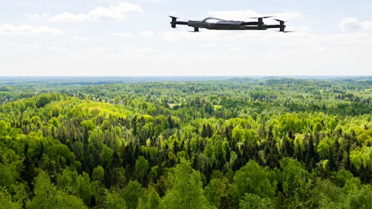
Satellites and drones bring an often more efficient and cost-effective method of monitoring deforestation over large areas.
Drones provide high-resolution, frequently updated imagery that complements traditional satellite-based remote sensing. Daniel Zuleta, postdoctoral researcher with the Forest Global Earth Observatory (ForestGEO), has said a single drone can cover an area in a few days that would take a team a year on foot. Drone-based monitoring can cover areas up to 400 hectares per day, enabling rapid assessment of large forest regions.
They offer unprecedented spatial and temporal resolution, enabling the detection of small-scale forest disturbances and the creation of detailed 3D forest structure models using photogrammetry and LiDAR. High-resolution drone imagery can detect individual trees, with some studies achieving 85-95% accuracy in tree species identification.
Reversing deforestation requires concrete actions beyond commitments by companies across the globe. Drone technology can be used to not only detect deforestation but also verify images taken by local communities on the ground, ensuring no deforestation has happened.
Empowering communities: Drone data for local forest conservation
As mentioned earlier, Participatory GIS (PGIS) plays a crucial role in empowering local communities to monitor and reverse deforestation using drone data.
This approach combines modern geospatial technologies with local knowledge and community engagement, creating a powerful tool for forest conservation.
Here’s a look at how PGIS empowers communities in this context using drone data:
- Community-led data collection and analysis
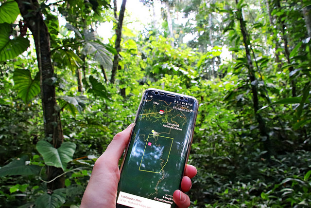
Participatory GIS enables local communities to actively engage in collecting and analyzing drone data. For example, in Peru’s Loreto region, nearly 80 native communities used drones and smartphones to monitor their territories, resulting in a 52% reduction in deforestation in the first year of implementation. This hands-on involvement fosters a sense of ownership and responsibility for forest monitoring.
- Real-time monitoring and rapid response
Drones enable frequent and detailed surveys of forest areas, allowing communities to detect and respond to deforestation activities quickly. In the Gran Chaco region of Paraguay, drone data collected by GLOBHE and analyzed by GainForest’s AI algorithms provides near real-time updates on forest status, enabling quick responses to threats. As a result, the use of drone data and smart AI tools is helping to reverse deforestation and empower local communities in Paraguay.
- Integration of local knowledge with high-tech solutions
PGIS allows communities to combine their traditional ecological knowledge with drone imagery and GIS analysis. This integration creates more comprehensive and contextually rich maps that reflect both the physical landscape and the cultural significance of different forest areas, leading to more effective conservation strategies.
- Evidence-based advocacy and decision-making
The high-resolution imagery and maps produced through drone-assisted PGIS provide communities with powerful visual evidence of forest changes. This data can be used in negotiations with authorities, in legal proceedings to protect forest rights, and to inform local decision-making processes. For instance, the NFTrees initiative in Paraguay uses drone data to create transparent, constantly updated proof-of-impact certificates for conservation efforts.
- Empowerment through technology transfer and collaboration
By learning to use drones and GIS tools, community members gain valuable technical skills. This knowledge transfer can lead to increased employment opportunities and a greater voice in forest management decisions. The collaboration between local communities, technology providers like GLOBHE, and organizations like GainForest illustrates how this empowerment can lead to more effective forest protection strategies.
Collaboration for community: UP42 & GLOBHE
In 2023, UP42 and GLOBHE teamed up to use drone data for monitoring and reversing deforestation while empowering local communities.
Here’s how it works: GLOBHE connects local drone operators with organizations that need high-quality images of hard-to-reach areas all over the world. Then, UP42’s geospatial platform provides access to this data, while enabling its processing and analysis alongside other Earth observation data sources—to get a really clear picture of what’s happening on the ground.
By bringing together local knowledge with high-tech drone data and analysis, partnerships such as these create a much more detailed and contextually rich understanding of how forests are changing.
This approach not only enhances monitoring capabilities but also provides powerful evidence for advocacy and decision-making in forest conservation efforts.
Looking ahead, combining drone technology with local community engagement through PGIS methods could really shake up how we approach forest conservation. As drone data becomes easier to use and more accessible, it has the potential to transform how local communities monitor, protect, and restore their forests.
It’s important to note though, that drone data as a tool should complement, and not replace, valuable fieldwork done on the ground.
What do you think about all this? How might things change if the people most affected by deforestation had the tools to monitor and protect their own lands? We’d love to hear your thoughts!
Did you like the article? Read more and subscribe to our monthly newsletter!

