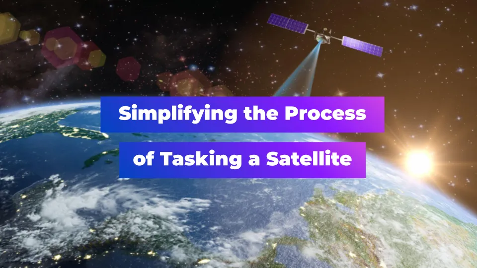
Simplifying the Process of Tasking a Satellite

Editor’s note: This article was written as part of EO Hub – a journalistic collaboration between UP42 and Geoawesome. Created for policymakers, decision-makers, geospatial experts and enthusiasts alike, EO Hub is a key resource for anyone trying to understand how Earth observation is transforming our world. Read more about EO Hub here.
If you let your imagination run, the scope of projects that are possible in the world of geospatial data is limitless. Our beautiful earth is an intricate canvas of complexity and satellite imagery offers us a unique vantage point, a lens through which we can reshape our understanding and interactions with the world around us. However, the sad reality is that countless projects, brimming with potential, don’t see the light of day because of apparent resource constraints and bureaucratic processes that stifle creativity and narrow the scope of what is perceived as viable.
One of the major offenders here is satellite tasking — the act of requesting the specific imagery that you need over your Area of Interest (AOI). Despite commercial satellites already covering the majority of the globe, it’s not necessarily a simple process to get the up-to-date satellite imagery that you need. Many users struggle with understanding the potential cost, evaluating the project’s feasibility, and getting the level of control that they need to optimize their financial investment.
In this article, we’ll discuss some of these challenges more specifically and then paint a picture of where the industry needs to go in order to liberate users from the roadblocks they face.
Confronting the Challenges of Satellite Tasking
If you’ve ever gone through the process of satellite tasking, you will likely have experienced some of these obstacles:
- Complex process. A typical satellite tasking exercise is not exactly the seamless experience you might expect given the sophistication of the technology itself. It can often require multiple back-and-forth email exchanges with providers and other partners to clarify the brief, negotiate the pricing, and obtain the results. The process is often opaque and it can be really frustrating to deal with — especially if your project is time-sensitive (which almost all projects are, to some extent). The industry would benefit greatly from improved workflows and more transparent satellite tasking — and it would significantly increase the scope of work that was possible.
- Lack of flexibility and accessibility. Compounding the complexity is the lack of aggregated data networks which means it can be difficult to access and request highly specific and precise satellite imagery. Consequently, many users find themselves ordering more data than they require because they need to fit into the specific offerings that a single provider can deliver. This increases the cost and results in a lot of wastage — all of which serves to stifle potential projects of all types. Users need more flexibility and precision in terms of their satellite tasking and we have the ability to deliver that — if we can transform the way that requests are submitted and actioned across the industry.
- Opaque pricing. When you’re dealing with individual satellite imagery providers the question of price can be a very delicate dance. As a user, you often don’t have much bargaining power so evaluating what a particular project is going to cost and how to craft your brief that fits into your budget is exceedingly difficult. This lack of transparency is a major hurdle for many projects and it could be wholly avoided if users had a better sense of the drivers and considerations when it comes to pricing satellite imagery. As an industry, we need better controls here and aggregation of resources so that we can cultivate a healthier marketplace overall. This will not only reduce prices for users (due to healthy competition) but it will speed up feasibility studies, reducing the wasted time and money spent on proposals, quotes, and pilots that were never going to be affordable in the first place.
- A need for faster delivery to enable real-time insights. It’s completely cliché at this point to talk about how fast the world is changing, but it’s a serious challenge that affects the vast majority of geospatial projects. In order to complete accurate and timely analysis that can deliver actionable insights, users need to be able to get their imagery quickly and efficiently. Unfortunately, the current processes don’t deliver this and you can often be waiting days or weeks for your data — which completely eliminates your ability to make near real-time decisions. The industry needs more reliable timelines and smoother tasking procedures so that we can utilize the most up-to-date information possible. Just that one change alone would radically change what is possible with this technology and open things up to a wide range of new possibilities.
These four barriers to entry have a significant impact on how satellite imagery is used across many different industries and users are crying out for solutions. If the industry can make meaningful steps toward solving some of these challenges, it can be a catalyst for innovation and it can revitalize projects that were previously discarded because of the tedious, expensive, and complicated procurement process.
Where are the Green Shoots?
It’s safe to say that there are a lot of people in the industry who have recognized the challenges and who are working to create solutions that can streamline the tasking process and make it easier for everyone involved. One example of this comes from the team at UP42, who have built a platform that aggregates many of the top satellite imagery providers and then serves up an easy-to-use interface for users to interact with. By opening access like this, users have complete flexibility when it comes to pricing, data types, and other parameters — because they can compare providers against each other and find the best fit for them. But, perhaps more importantly, the platform makes satellite imagery more accessible than ever – turning a tedious process into one that feels like a natural extension of many of the best GIS software solutions out there.
Transitioning to a more modern GUI (and away from email exchanges) and integrating providers to allow for more advanced tasking seems inevitable at this point if you look at the way that technology has advanced in other industries. But another positive step forward in geospatial data specifically is the ability to combine different types of sensors and data so that a user can access a more holistic dataset for their needs. What this looks like in practice is a user being able to integrate data from multiple providers into one data pipeline, including their own proprietary data if they wish.
For example, UP42 allows a user to define their specific AOI and then gather different types of data in one place. This optimization goes a long way toward enabling more nuanced and sophisticated geospatial use cases, and it greatly accelerates the speed of available analysis.
Additionally, UP42 unveiled a new tasking ordering flow that addresses the industry challenge of opaque pricing. A lack of clarity, combined with long waiting times for tasking quotes, can disrupt projects and budget planning. Now, users have a broad overview of all the different providers, collections they offer, resolution, minimum order restrictions, and cost beforehand.
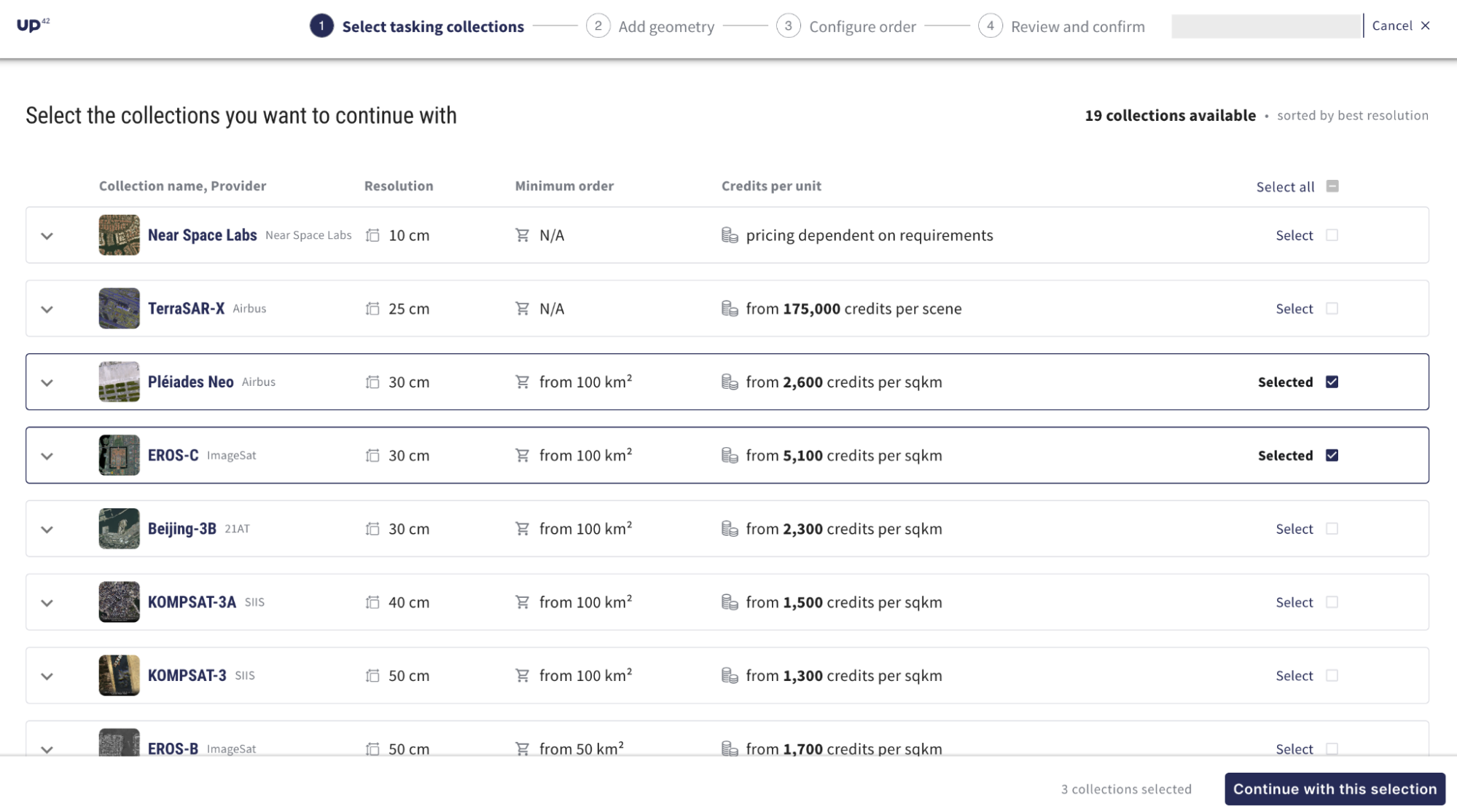
Gone are the days of endless emails for tasking orders. Hassle-free tasking with UP42 streamlines the entire process with a single, integrated solution. You can place tasking orders, get instant price estimates, and then download imagery into your workflow on the platform. By reducing the complexity in this way, it’s now possible to better focus on the task at hand. The team has written detailed documentation about tasking, including how to make the most of the wealth of data sources available on their marketplace and platform to analyze and innovate.
With more effective analysis comes better results and more meaningful change across a wide range of use cases. In fact, it feels like the efficiencies being achieved through some of these modern platforms might just be the unlock that can dramatically increase the utility of the wonderful satellite data that providers are gathering. Of course, more still needs to be done here to truly achieve the potential that modern satellite tasking has for us, but it’s good to see that there are companies out there who are building solutions that stride toward this future.
We’ve already seen major improvements in areas such as data storage, privacy protection, data quality, collaboration, and more — but this feels like the next frontier. As a community, we need to continue lobbying for improvements to satellite tasking because it is one of the major pain points that we all feel. By supporting the organizations that are making things easier, we can catalyze wide-scale change to the model of how things are done, and the industry can reap tremendous rewards as a result.
The Future of Satellite Tasking
If we let ourselves dream a little, the future of satellite tasking might resemble the experience of ordering our favorite food on an app. We’d select from a wide range of options, specify exactly what we wanted, have immediate price transparency, and then — with one click — it would be delivered to us. That’s what the future of satellite tasking needs to look like.
Having accurate price estimations, intuitive order processes, and a significant increase in accessibility can make a world of difference to what is possible. And with a combination of technological advances, software integrations, and customer-led innovation – we can definitely get there.
When we do, then the only limit will be our imagination. With a simpler and more effective process, access to satellite imagery ceases to be a barrier and instead becomes an enabler for so many of the exciting projects that we have yet to discover. Let’s get the tools in the hands of our community and watch them change the world.
Did you like this article? Read more and subscribe to our monthly newsletter!


#Sector
Next article
Building Early-Warning and Monitoring Systems to Mitigate the Impact of Climate-Related Emergencies

Editor’s note: This article was written as part of EO Hub – a journalistic collaboration between UP42 and Geoawesome. Created for policymakers, decision-makers, geospatial experts and enthusiasts alike, EO Hub is a key resource for anyone trying to understand how Earth observation is transforming our world. Read more about EO Hub here.
Climate emergencies on the rise
The devastating impacts of climate change are becoming increasingly evident. In 2022 alone, Hurricane Ian, a Category 5 Atlantic hurricane, wreaked havoc across Cuba, Florida, and the Carolinas, causing over $113 billion in damages and claiming at least 161 lives. This storm is the deadliest hurricane to strike Florida since the 1935 Labor Day hurricane and the third-costliest weather disaster on record worldwide, serving as a stark reminder of the growing threat posed by extreme weather events.
Hurricane Ian is just one example of the many ways climate change is impacting our planet. A report by Christian Aid further highlights this grim reality, estimating that the ten largest natural disasters in 2022 caused a staggering $168 billion in economic losses. These disasters also inflict a heavy human toll, particularly in developing countries. Christian Aid’s analysis shows that these 10 events resulted in at least 3,275 deaths and displaced tens of millions of people.
Moreover, The World Meteorological Organization (WMO)’s State of the Global Climate 2023 report highlights record-breaking levels of greenhouse gases, rising temperatures, and worsening ocean conditions. These factors are fueling extreme weather events such as heatwaves, floods, droughts, wildfires, and intense cyclones, causing widespread devastation and economic losses.
The growing importance of real-time early-warning systems
Despite the grim outlook, proactive measures can lessen the impact of climate-related emergencies. One such measure is the development of early warning and monitoring systems that utilize satellite technology. These systems predict, detect, and track the development of extreme weather events, providing communities with crucial lead time to prepare and evacuate.
Early warning information is disseminated through broadcasts, maritime channels, and other radio communication channels, allowing for timely public advisories and preparation. Finally, satellite data plays a vital role in assessing the extent of damage after a climate-related emergency, informing and optimizing relief operations.
According to the United Nations, these systems can yield a tenfold return on investment by preventing deaths and injuries. Recognizing this importance, the UN Secretary-General set an ambitious goal in 2022: to ensure everyone has access to an early warning system by 2027. The urgency for such systems is further underscored by projections from the WHO, which forecast an additional 250,000 deaths annually due to climate change between 2030 and 2050.
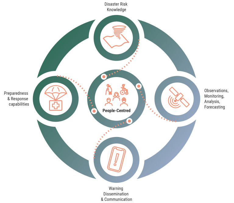
Early warning systems act as the first line of defense by continuously monitoring climate indicators through a network of satellites, ground stations, and sensors. Advanced models then analyze this real-time data to identify potential threats like floods, droughts, or heatwaves — allowing communities to prepare and respond proactively.
For example, early warning systems can monitor the path of cyclones, typhoons, and hurricanes at sea before they make landfall. They can detect hot spots in active volcanoes and monitor volcanic deformation, as well as track the progress of floods in large river basins.
Early warning systems can be classified by the type of hazard they assess (geological, hydrometeorological, biological, etc) and the level they operate at (community, national, regional, global). Satellite data is used across these different types of early warning systems.
The Early Warnings for All initiative is a groundbreaking effort to ensure everyone on Earth is protected from hazardous weather, water, or climate events through life-saving early warning systems by the end of 2027. (Source: World Meteorological Organization)
Wildfires fueled by climate change rage across the globe
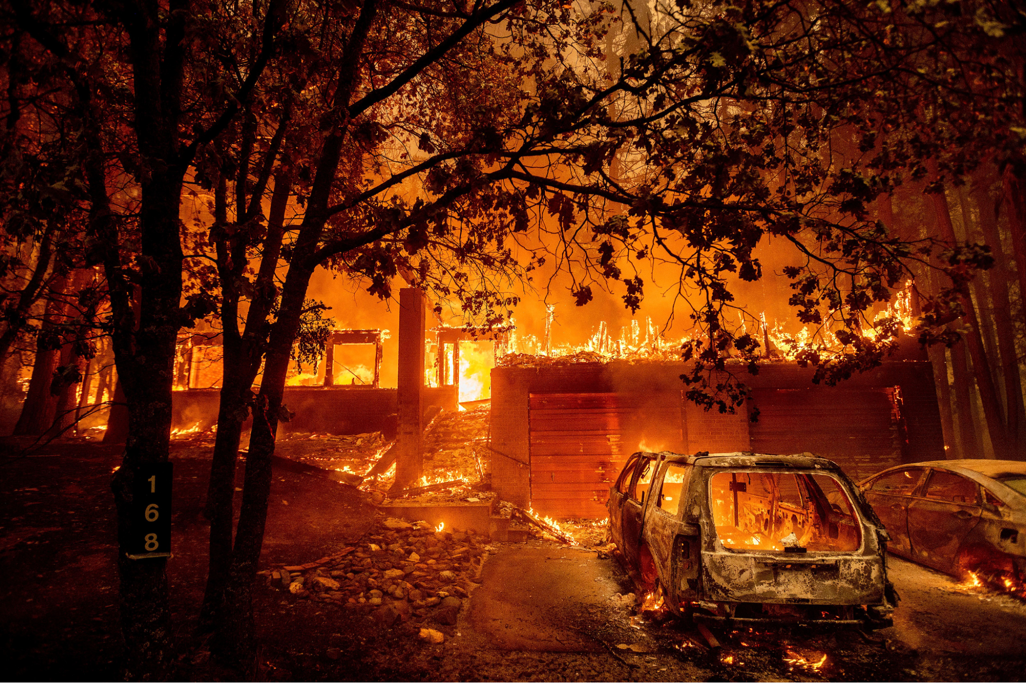
Climate change is fueling a devastating trend of increasingly frequent and severe wildfires around the world. Uncontrolled wildfires, defined as unplanned and unwanted fires burning in natural areas, pose a significant threat to natural ecosystems and human communities. This puts the health and well-being of people across the globe at increasing risk.
California serves as a stark example, with 80% of its most devastating wildfires occurring in the past decade, highlighted by the tragic 2018 Camp Fire, which resulted in 85 fatalities and the destruction of the town of Paradise. Since 2010, the US has witnessed over 50 thousand wildfires each year.
Wildfires aren’t just a US issue. In 2023, Canada shattered wildfire records, with flames consuming over 18 million hectares. It’s been announced that 2023 was Europe’s worst year for wildfires this century and Chile recently battled devastating fires in February 2024 that tragically claimed lives and devastated over 29,000 hectares of land.
Rising temperatures, droughts, and dry conditions create perfect fuel for wildfires. Their unpredictable nature demands reliable risk management tools to protect lives and the environment.
Evolution of wildfire tracking: From traditional methods to satellite imagery
Several traditional methods are still used to track wildfires alongside satellite technology:
- Fire lookouts in towers or on high vantage points scan for smoke plumes visually. This method, however, is limited by the range of human sight and weather conditions.
- Aerial patrols with planes and helicopters can cover larger areas, but they remain expensive and time-consuming.
- Ground teams patrol on foot, providing crucial on-the-ground assessment and fire suppression efforts. However, their reach remains limited.
- Community watch programs rely on residents to report smoke sightings. While valuable for early detection, these programs can be less reliable and lack a comprehensive view.
Satellite imagery revolutionized wildfire management by overcoming these limitations. It provides real-time data and covers most of our planet, making it an indispensable tool for today’s fire response.
Role of thermal satellites in current wildfire early-warning systems
An effective early warning system for wildfires hinges on identifying at-risk areas before flames erupt. This is where satellite technology shines. Thermal satellites, using infrared radiation to measure temperature variations, monitor vast landscapes and detect potential wildfires by identifying high temperatures or moisture-stressed areas.
Notably, thermal imagery is unaffected by smoke but cannot penetrate clouds. The information it provides proves invaluable for pinpointing potential fire zones and tasks like tracking heat islands, monitoring water temperature fluctuations, and assessing soil moisture levels – all crucial aspects of wildfire risk management.
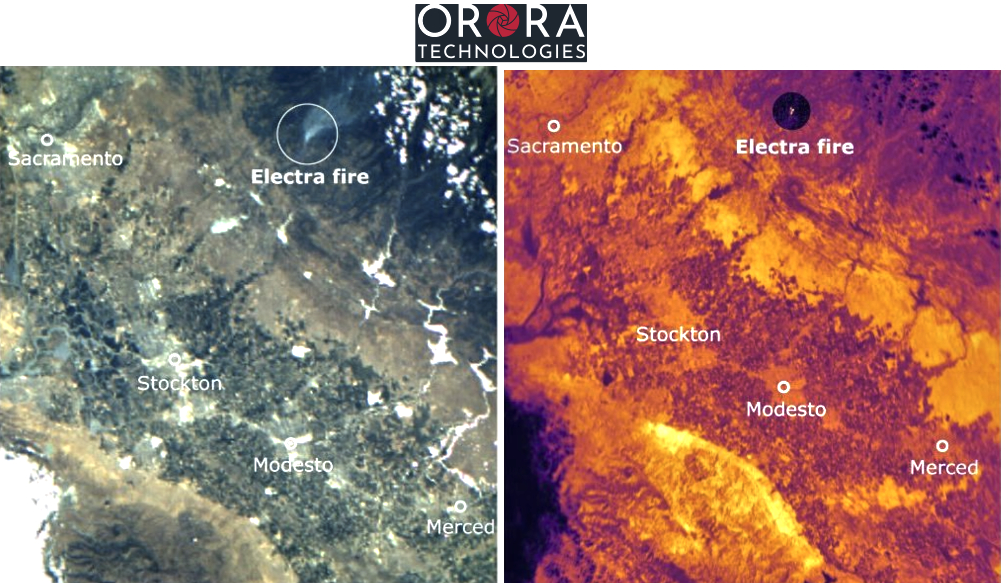
OroraTech’s leading-edge satellite network delivers low-latency, global coverage, near-real-time thermal data products. Recently, the company teamed up with UP42, a geospatial developer platform and marketplace
This partnership brings a thermal-based wildfire solution for real-time detection and monitoring. With OroraTech’s high-resolution thermal data and UP42’s on-demand tasking and archive imagery, it’s possible to easily and quickly create monitoring and early warning systems for at-risk areas.
Furthermore, OroraTech’s tasked data is managed in UP42’s STAC-compatible storage, simplifying the search and management of data for easier processing and integrations.
This innovative system safeguards communities by enabling the detection of fires as small as 4×4 meters and delivering data within 3 minutes, allowing for a swift response and potentially saving millions of dollars per fire.
Building a complete picture of fire behavior using AI
Satellites play a crucial role not only in monitoring wildfires, but also in developing effective response strategies. They provide real-time data on fire spread direction, intensity, estimated size, and burning area, enabling responders to target their efforts and minimize damage to people and property.
However, for truly precise fire behavior prediction, this satellite data needs to be integrated with other critical information. By integrating satellite data with wind, land cover, and slope information, AI models create a comprehensive picture of potential fire behavior, enabling responders to predict fire paths and develop effective response strategies.
By comparing pre-fire and post-fire images, we can create burn severity maps that assess burned vegetation and soil precisely, allowing us to create a clear picture of the fire’s footprint and to track vegetation recovery over time.
Products like OroraTech’s WildFire Solution provide detailed fire origin and spread analysis, high-resolution burn severity maps, and historical fire data to guide restoration efforts, risk mitigation, and future prevention strategies.
Real-life example: Thermal satellites monitoring the Dixie Fire (2021)
The Dixie Fire, which ravaged over a million acres in Northern California in 2021, became the largest single wildfire in the state’s history at the time. Satellites, particularly those equipped with thermal imaging capabilities, were critical in managing this massive blaze.
Throughout the fire’s course, thermal satellite data provided updates every 12 hours on the fire’s perimeter and movement, allowing fire officials to predict the fire’s path and issue timely evacuations for threatened communities.
Strong visuals generated from data empowered incident management to carry out quick and efficient decision-making.
Conclusion on Early-Warning and Monitoring Systems
While climate change brings challenges like wildfires, we have the power to build a more resilient future.
Early warning systems powered by satellites and sensors give communities crucial time to prepare and evacuate. These advanced technologies work alongside individual efforts like having disaster plans and emergency kits to significantly increase preparedness.
By investing in robust and universally accessible EWS, staying informed, and working together, we can create a collaborative society prepared to navigate climate challenges, safeguard vulnerable communities, and empower them to face the future.
Did you like this article about early-warning systems? Read more and subscribe to our monthly newsletter!

