SBAS Interoperability Working Group: Setting up a common standard

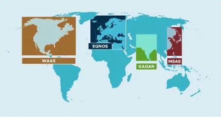
The SBAS (Satellite Based Augmentation System) Interoperability Working Group consisting of more than 30 specialists overseeing the world’s five satellite navigation augmentation systems from United States of America, Russia, European Union, Japan and India gathered at Russia’s Svetloe Space observatory in late june this year, planning for a high-performance future with many more navigation satellites in orbit.

The Satellite Based Augmentation Systems basically complement the Global Navigation Satellite Systems by compensating for certain disadvantages of such Global systems in terms of accuracy, integrity, continuity and availability. SBAS helps improve positioning accuracy by sending real time corrections for Ionospheric errors. In a sense the SBAS works like a Real Time Kinematic (RTK) network by sending corrections to the user thereby helping improve position accuracy.

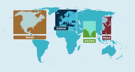
However, the current SBAS do not have any mechanism for interoperability i.e. USA’s WAAS has a different message format when compared to EU’s EGNOS. Interestingly all SBAS utilize GPS as their basic GNSS constellation for which they send corrections to the user on the ground (or to an aircraft).

Current SBAS Constellations

Current SBAS Constellations

The working group is meeting twice an year with the main objective of ensuring that the various systems work together on a standard basis, so that an end user can seamlessly switch from using one system to another. In the current scenario, an aircraft that is flying over Europe can’t utilize GAGAN even if it able to track both – thanks to the different message formats that each SBAS uses but the SBAS Interoperability Working Group is hopeful that this be soon rectified.

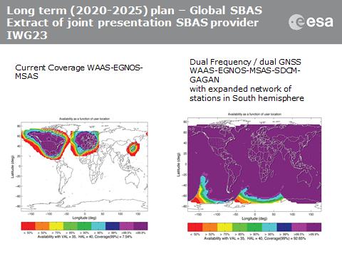
Planned SBAS Coverage. Image Courtesy: ESA

Planned SBAS Coverage. Image Courtesy: ESA

The extended coverage and interoperability will greatly help improve accuracy of positioning worldwide and maybe even help in cooperation between different Global Navigation Satellite Systems!


Did you like this post? Read more and subscribe to our monthly newsletter!

Say thanks for this article (0)
The community is supported by:
Become a sponsor
#
#Agriculture #Energy #Environment #Environmental Protection #ESG #Featured #Humanitarian #Pansharpening #Real Estate #Satellites #Science #Transportation
5 Ways to Use Pansharpening on Satellite Imagery
Nikita Marwaha Kraetzig 10.16.2024
AWESOME 5
#Agriculture #Construction #Energy #Environment #Environmental Protection #Financial Services #GeoDev #Government #Humanitarian #Ideas #Natural Resources #Orthorectification #Satellites #Transportation
Why Orthorectification is Key for Real-World Terrain Mapping and How To Use It
Nikita Marwaha Kraetzig 10.14.2024
AWESOME 2
#Agriculture #Environmental Protection #Geospatial analytics #Geospatial for Good #Orora Technologies #Satellite tasking #Vegetation Management
Building Early-Warning and Monitoring Systems to Mitigate the Impact of Climate-Related Emergencies
Hassan Safieddine 05.15.2024
AWESOME 4
Next article

IRNSS 1-A successfully launched: Indian Regional Navigation Satellite System project begins!

A decade ago, Scientists at the Indian Space Research Organization (ISRO) were starting to explore the possibility of having an Indian alternative to the GPS system, at least at a regional scale. A dream and a vision by the world’s largest democracy to have its own satellite navigation system is now taking shape in the form of ” The Indian Regional Navigation Satellite System (IRNSS) 

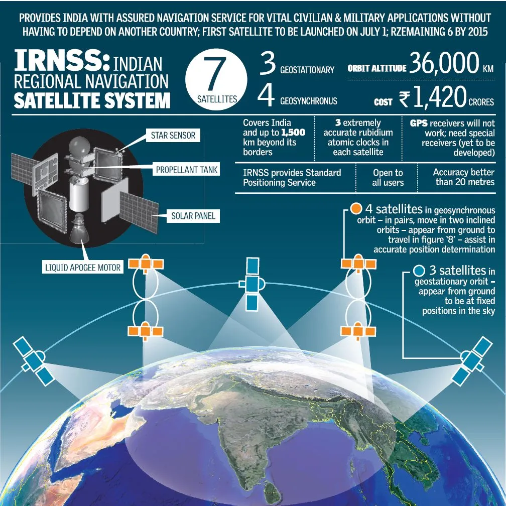
The first satellite of the 7 satellite constellation, IRNSS 1A has been launched successfully from Sathish Dawan Space Centre, Sriharikota. It was a perfect launch during the midnight of July 1st! IRNSS 1-A is officially India’s first dedicated Navigation Satellite! ISRO’s Polar Satellite Launch Vehicle, PSLV – 22 successful placed IRNSS 1-A in its orbit, the launch vehicle was previously used for launching Chandrayaan -1 (India’s Moon Mission).

IRNSS is only a regional navigation satellite and will in no way be a direct competitor to the Global Navigation Satellite Systems like GPS or GLONASS. India has already launched its own SBAS system in GAGAN (GPS Aided Geo Augmented Navigation) and the latest regional navigation satellite system is only going to help the GNSS Industry in the country grow. The design of IRNSS allows for an additional 3 satellites to be added to the original 7 satellites that are planned to be set into orbit by the end of 2015. However it would not be possible for the system to be converted into a Global system in the future. With launch failures of GLONASS satellites, it looks like GPS is set to be the standard for the time being, Beidou from China being the only realistic competition that can arise in the future with GALILEO struggling to move forward.

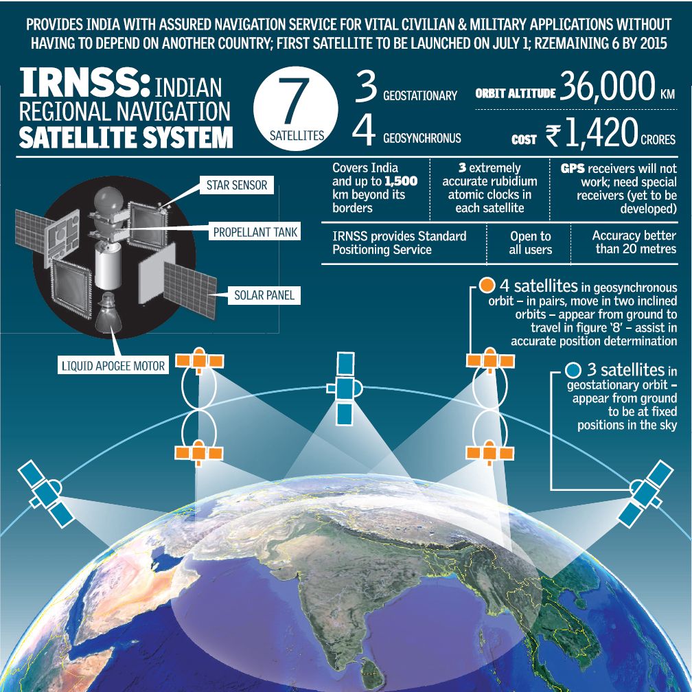
 Inside IIRNSS 1-A

A picture says a thousand words and a documentary tells you the entire story.

If you are interested in having a closer look at the tech specs and other IRNSS information – here’s the link

For a country that became Independent during Midnight, it is rather fitting that its first major step in navigation satellite system should arrive on the midnight of July 1st!

Kudos ISRO! The Indian Regional Navigation Satellite System project is now underway!


Did you like this post? Read more and subscribe to our monthly newsletter!

Read on
Search