Radar images used to map floods
The reflection of radar waves on the surface highly depends on the dielectric properties of the impacted objects. Among other things, the radar wave is reflected by water and objects containing water. Since the radar sensor is always inclined to the side, still water bodies reflect the wave off the sensor forwarding it in the according angle and same direction it came from. Therefore, still water bodies are areas with missing information on reflected waves. They appear as black areas and distinguish themselves from the displayed grey or white remaining land terrain. Hence, radar intensity images are highly eneficial for flood mapping.
Between January 9 and 11 2015 two winter storms passed over Denmark issuing flood warnings for different parts of the country. To map the extent of the flooding, the water management company DHI used radar intensity images from the German space borne satellite TerraSar-X. The advantage of radar images lies in their ability to be independent from weather and light conditions. It is possible to acquire radar images during the night and regardless of the current weather conditions such like heavy wind, massive cloud and rain. – Only heavy rain clouds will reflect radar waves at the X-band, which is used by TerraSar-X. The images were provided by Airbus Defence and Space, which has the commercial distribution of the images.
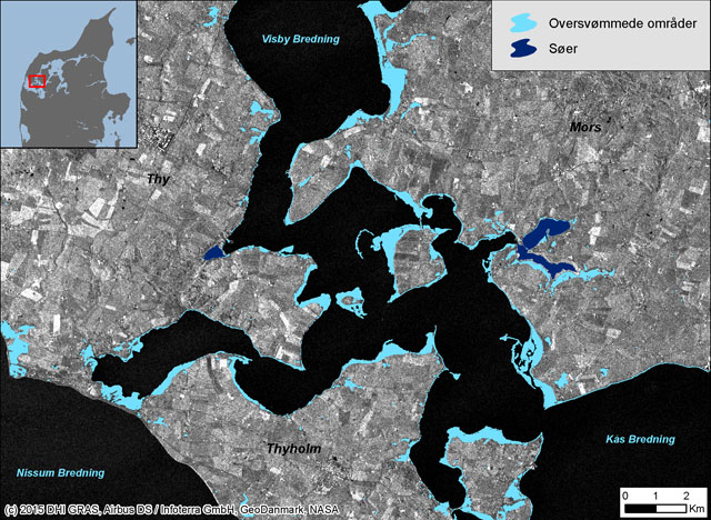
The image below shows flooded areas in Northern Jutland around Limfjorden, Denmark. The flooded areas are indicated by the light blue colour. Oceans appear as dark surfaces (as the waves are also reflected there), whereas the inland areas are displayed as grey or white surfaces.

Flood mapping – Flooded area over Northern Jutland demarked as liht blue surfaces. Source: Geospatial Solutions
Source: Geospatial Solution
Did you like this post about flood mapping? Read more and subscribe to our monthly newsletter!


