NASA’s Aura Satellite: Tracks of Shipping Pollution
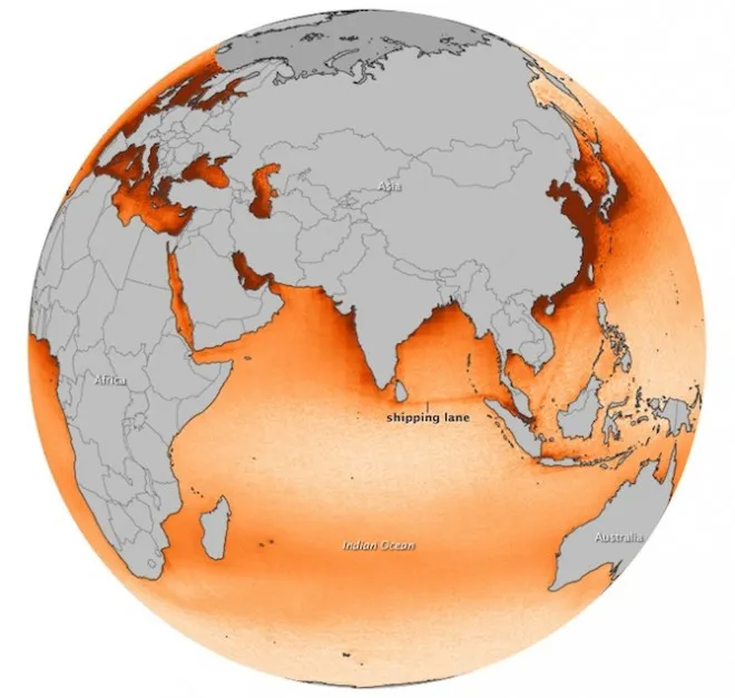
The Ozone Monitoring Instrument on board NASA’s Aura Satellite is capable of tracking the pollution caused by ships in the seas. Satellite imagery released by NASA showing Nitrogen Dioxide (NO2) emission is definitely raising concerns. The extent of pollution is nothing unexpected but surely it is time to look for greener ways to take technology forward. This satellite is a pioneering Earth observation spacecraft launched in 2004. Its primary mission is to study the Earth’s atmosphere, focusing on air quality, climate change, and ozone depletion. Equipped with advanced instruments,
Aura provides valuable data to understand atmospheric composition and its impact on global environmental processes. Beyond its atmospheric studies, it also plays a role in monitoring pollution levels, tracking the movement of greenhouse gases, aerosols, and other pollutants. Its observations contribute to improving air quality forecasts, understanding the ozone layer’s dynamics, and informing policies aimed at protecting the Earth’s environment. Aura’s comprehensive data sets are invaluable for researchers, policymakers, and environmentalists worldwide, fostering a deeper understanding of our planet’s interconnected systems.
Interestingly, regions near to the coast look more polluted. But actually, the high seas are equally polluted but the current offer the possibility of dispersion where as near the coast, human activity only increases pollution.
There is tons of such imagery and analysis from NASA’s satellite. Here’s the link
Did you like this post about NASA’s Satellite? Read more and subscribe to our monthly newsletter!


