Micro-Technology for Navigation, Positioning and Timing
 Our location addiction and expectation to be able to seamlessly navigate from one place to another is something we take for granted. The behaviour of checking google maps for directions has become so common that when I ask for directions in a new city, the person (if he/she is not old) is surprised and invariably has to check the smartphone for directions.
What happens when we are denied the luxury of having a GPS/GNSS. Are other technologies capable of helping us navigate when GPS/GNSS is unable to do so? A few weeks ago, I read an interesting article on what’s next in the field of navigation? Naturally as a Geomatics engineer I was intrigued by the latest technologies that were being developed to substitute GNSS in certain applications. One of the most promising areas for new age navigation is Micro-Technology.
Most defense establishments around the globe are looking to Micro-Technology to help tide over GPS emergencies which by the way look very much possible in the near future. The DARPA (Defense Advanced Research Projects Agency) has an entire team working on such technologies: Micro-Technology for Positioning, Navigation and Timing (Micro-PNT) program. One of the primary goals of the project is to to develop technology for self-contained, chip-scale inertial navigation and precision guidance. Micro-Gryos are very popular in this regard and Northrop Grumman group has come up with a new prototype “micro-Nuclear Magnetic Resonance Gyro (micro-NMRG)” for the MICRO-PNT division of DARPA.
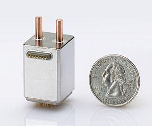 Micro-Nuclear Magnetic Resonance Gyro! Definitely sounds way too complex 😉 The concept behind this complex sounding technology device is spin of an atomic nuclei. Fundamentally, the micro-NMRG technology utilizes the use of the atomic nuclei to detect and measure rotation which in reality helps us locate ourselves and thereby navigate from A to B. The advantage of using such a Gyro in comparison to the one that is routinely being in our smartphones is that the Nuclei based gyro has no moving parts which helps avoid measuring unwanted vibration and acceleration that may be caused to the mechanical parts.
So has it solved our dependence on GPS/GNSS?
Well the answer is no! The Gyro is part of a bigger puzzle that will over a period of time help develop an alternative to GPS/GNSS but in reality the gyro is rather useless without knowing where we are i.e. initial location. GPS/GNSS still happens to be that technology that provides us information to answer the “Where” question in a global scenario.
micro-technology for navigation, positioning and timing: Promising!
Did you like this article? Read more and subscribe to our monthly newsletter!


