Key takeaways from report on the potential of Earth Observation in Africa
A report published by the World Economic Forum (WEF) in collaboration with Digital Earth (DE) Africa explores the potential economic impact of Earth Observation (EO) data in Africa.
Published on January 15th, the report predicts that the impact of DE Africa could surpass $2 billion per year by 2024. It mentions three key areas that will benefit from the information provided by DE Africa: the EO industry, the agricultural sector, and the mining industry.
Here are 3 takeaways from the report.
1. Countries still face challenges of Earth Observation (EO) data availability, quality, and useability preventing them from utilizing its full potential
The lack of actionable data and information on key trends is hampering the progress of new technologies to tackle issues facing Africa.
According to a 2017 report, the adoption of EO globally can contribute to the attainment of 16 Sustainable Development Goals (SDGs).
Specifically, using EO within Africa is directly relevant to the attainment of:
- Zero hunger – SDG 2
- Clean water and sanitation – SDG 6
- Industry, innovation, and infrastructure – SDG 9
- Sustainable cities and communities – SDG 11
- Climate action – SDG 13
- Life below water – SDG 14
- Life on land – SDG 15
Consequently, if EO data were easier to access and use across the continent, countries could overcome several challenges in meeting the needs of their growing populations.
2. DE Africa can ease access to EO data
The Open Data Cube (ODC) is a non-profit, open-source project that provides an innovative and freely accessible solution. It makes it easier to use satellite data to its full potential by:
- Streamlining data distribution management for providers
- Lowering technical barriers for users
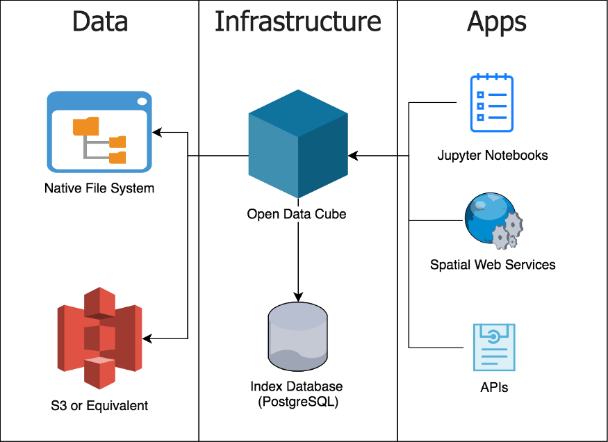
A simple diagram of what makes up an ODC deployment (Source)
Digital Earth Africa, formerly Africa Regional Data Cube, has scaled up ODC technology to the entire African continent.
It is translating EO data into information and services and, as a result, increasing its useability.
In fact, it will be the world’s largest open data cube providing insights into various issues including flooding, droughts, soils, coastal erosion, agriculture, forests and land use land change, water availability and quality, and changes to human settlements.
Leveraging from the lessons and achievements of DE Australia, and the Africa Regional Data Cube, DE Africa will certainly shape the growth of all sectors across the continent.
3. Realisation of the full benefits of EO data depends on the development and adoption of geospatial industry best practices
The report estimates that DE Africa will speed up the growth of Africa’s EO industry by $500 million a year from 2024. (Estimated from GeoBuiz – Geospatial Industry Outlook & Readiness Index, 2018 and 2019)
The estimate assumes that:
- DE Africa will raise the quality of African Data Infrastructure (i.e., availability of EO images in the region), by halving the distance between Africa and Australia (where a similar project is in full force) by 2024.
- DE Africa could stimulate African countries to improve other policy-related indicators. That by 2024 Africa will reproduce the best practices adopted in different areas by the top-performing countries.
Therefore, to unlock the full potential of EO data, countries should adopt the following best practices:
- Have a national geospatial data infrastructure.
- Have an enabling national geospatial policy framework (inclusive of data dissemination and data access). The framework will support the implementation of National Spatial Data Infrastructure, surveying and mapping policies, open data policies for geospatial data and otherwise, and Space policies.
- Build and invest in institutions offering distinctive courses for higher education and research. This will develop a highly knowledgeable and talented pool of human resources for overall user adoption, industry and entrepreneurship, and innovation advancement.
- Have capabilities to integrate geospatial information with applications/hardware and software of varied ecosystems such as IT and Engineering. This will lead to the creation of unique solutions, generating substantial economic and social value.
- Have a vibrant geospatial industry ecosystem. Countries should have dedicated geospatial technology business incubation programs as part of national programs. Additionally, they should have well-diversified representative industry bodies, professional member networks, and institutions. Further, they need a diverse spread of products, services, and solutions categories for various geospatial technology domains.
Eventually, even though DE Africa will improve the geospatial data infrastructure on the continent, in order to unlock the full potential of EO, the African ecosystem of industry sectors and government institutions need to develop the remaining best practices.
Read the full report and share your thoughts with us.
Did you like the article? Read more and subscribe to our monthly newsletter!


