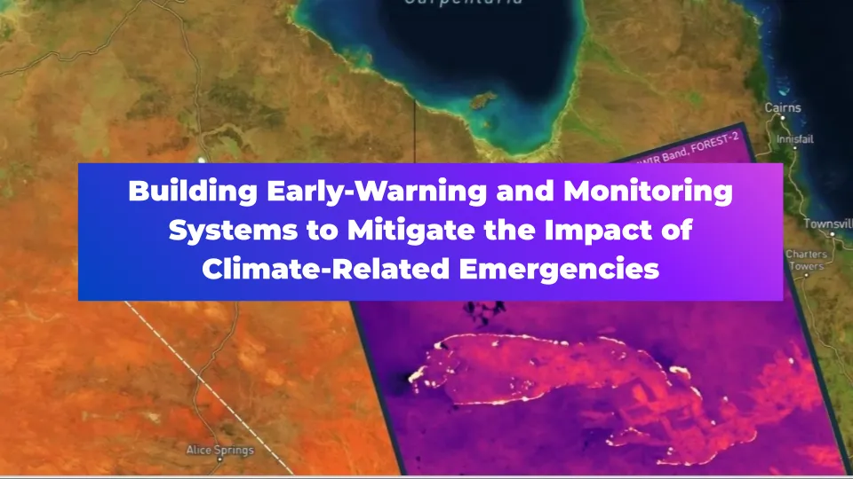
Building Early-Warning and Monitoring Systems to Mitigate the Impact of Climate-Related Emergencies

Editor’s note: This article was written as part of EO Hub – a journalistic collaboration between UP42 and Geoawesome. Created for policymakers, decision-makers, geospatial experts and enthusiasts alike, EO Hub is a key resource for anyone trying to understand how Earth observation is transforming our world. Read more about EO Hub here.
Climate emergencies on the rise
The devastating impacts of climate change are becoming increasingly evident. In 2022 alone, Hurricane Ian, a Category 5 Atlantic hurricane, wreaked havoc across Cuba, Florida, and the Carolinas, causing over $113 billion in damages and claiming at least 161 lives. This storm is the deadliest hurricane to strike Florida since the 1935 Labor Day hurricane and the third-costliest weather disaster on record worldwide, serving as a stark reminder of the growing threat posed by extreme weather events.
Hurricane Ian is just one example of the many ways climate change is impacting our planet. A report by Christian Aid further highlights this grim reality, estimating that the ten largest natural disasters in 2022 caused a staggering $168 billion in economic losses. These disasters also inflict a heavy human toll, particularly in developing countries. Christian Aid’s analysis shows that these 10 events resulted in at least 3,275 deaths and displaced tens of millions of people.
Moreover, The World Meteorological Organization (WMO)’s State of the Global Climate 2023 report highlights record-breaking levels of greenhouse gases, rising temperatures, and worsening ocean conditions. These factors are fueling extreme weather events such as heatwaves, floods, droughts, wildfires, and intense cyclones, causing widespread devastation and economic losses.
The growing importance of real-time early-warning systems
Despite the grim outlook, proactive measures can lessen the impact of climate-related emergencies. One such measure is the development of early warning and monitoring systems that utilize satellite technology. These systems predict, detect, and track the development of extreme weather events, providing communities with crucial lead time to prepare and evacuate.
Early warning information is disseminated through broadcasts, maritime channels, and other radio communication channels, allowing for timely public advisories and preparation. Finally, satellite data plays a vital role in assessing the extent of damage after a climate-related emergency, informing and optimizing relief operations.
According to the United Nations, these systems can yield a tenfold return on investment by preventing deaths and injuries. Recognizing this importance, the UN Secretary-General set an ambitious goal in 2022: to ensure everyone has access to an early warning system by 2027. The urgency for such systems is further underscored by projections from the WHO, which forecast an additional 250,000 deaths annually due to climate change between 2030 and 2050.
Early warning systems act as the first line of defense by continuously monitoring climate indicators through a network of satellites, ground stations, and sensors. Advanced models then analyze this real-time data to identify potential threats like floods, droughts, or heatwaves — allowing communities to prepare and respond proactively.
For example, early warning systems can monitor the path of cyclones, typhoons, and hurricanes at sea before they make landfall. They can detect hot spots in active volcanoes and monitor volcanic deformation, as well as track the progress of floods in large river basins.
Early warning systems can be classified by the type of hazard they assess (geological, hydrometeorological, biological, etc) and the level they operate at (community, national, regional, global). Satellite data is used across these different types of early warning systems.
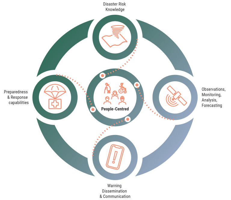
The Early Warnings for All initiative is a groundbreaking effort to ensure everyone on Earth is protected from hazardous weather, water, or climate events through life-saving early warning systems by the end of 2027. (Source: World Meteorological Organization)
Wildfires fueled by climate change rage across the globe
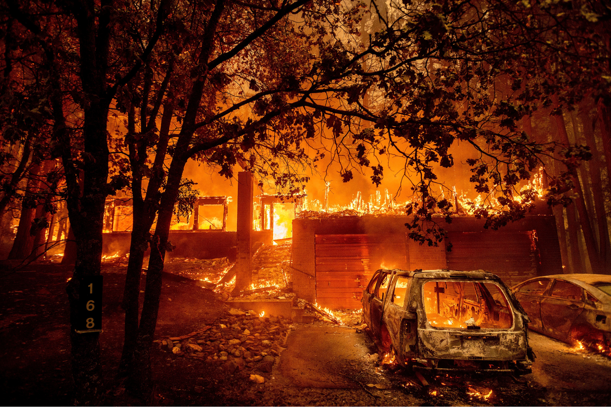
Climate change is fueling a devastating trend of increasingly frequent and severe wildfires around the world. Uncontrolled wildfires, defined as unplanned and unwanted fires burning in natural areas, pose a significant threat to natural ecosystems and human communities. This puts the health and well-being of people across the globe at increasing risk.
California serves as a stark example, with 80% of its most devastating wildfires occurring in the past decade, highlighted by the tragic 2018 Camp Fire, which resulted in 85 fatalities and the destruction of the town of Paradise. Since 2010, the US has witnessed over 50 thousand wildfires each year.
Wildfires aren’t just a US issue. In 2023, Canada shattered wildfire records, with flames consuming over 18 million hectares. It’s been announced that 2023 was Europe’s worst year for wildfires this century and Chile recently battled devastating fires in February 2024 that tragically claimed lives and devastated over 29,000 hectares of land.
Rising temperatures, droughts, and dry conditions create perfect fuel for wildfires. Their unpredictable nature demands reliable risk management tools to protect lives and the environment.
Evolution of wildfire tracking: From traditional methods to satellite imagery
Several traditional methods are still used to track wildfires alongside satellite technology:
- Fire lookouts in towers or on high vantage points scan for smoke plumes visually. This method, however, is limited by the range of human sight and weather conditions.
- Aerial patrols with planes and helicopters can cover larger areas, but they remain expensive and time-consuming.
- Ground teams patrol on foot, providing crucial on-the-ground assessment and fire suppression efforts. However, their reach remains limited.
- Community watch programs rely on residents to report smoke sightings. While valuable for early detection, these programs can be less reliable and lack a comprehensive view.
Satellite imagery revolutionized wildfire management by overcoming these limitations. It provides real-time data and covers most of our planet, making it an indispensable tool for today’s fire response.
Role of thermal satellites in current wildfire early-warning systems
An effective early warning system for wildfires hinges on identifying at-risk areas before flames erupt. This is where satellite technology shines. Thermal satellites, using infrared radiation to measure temperature variations, monitor vast landscapes and detect potential wildfires by identifying high temperatures or moisture-stressed areas.
Notably, thermal imagery is unaffected by smoke but cannot penetrate clouds. The information it provides proves invaluable for pinpointing potential fire zones and tasks like tracking heat islands, monitoring water temperature fluctuations, and assessing soil moisture levels – all crucial aspects of wildfire risk management.
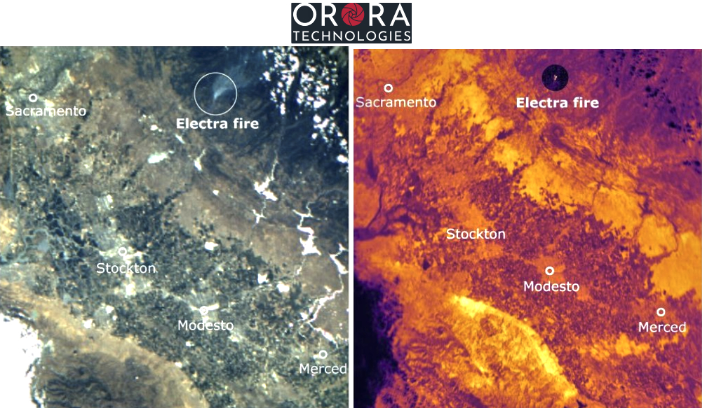
OroraTech’s leading-edge satellite network delivers low-latency, global coverage, near-real-time thermal data products. Recently, the company teamed up with UP42, a geospatial developer platform and marketplace
This partnership brings a thermal-based wildfire solution for real-time detection and monitoring. With OroraTech’s high-resolution thermal data and UP42’s on-demand tasking and archive imagery, it’s possible to easily and quickly create monitoring and early warning systems for at-risk areas.
Furthermore, OroraTech’s tasked data is managed in UP42’s STAC-compatible storage, simplifying the search and management of data for easier processing and integrations.
This innovative system safeguards communities by enabling the detection of fires as small as 4×4 meters and delivering data within 3 minutes, allowing for a swift response and potentially saving millions of dollars per fire.
Building a complete picture of fire behavior using AI
Satellites play a crucial role not only in monitoring wildfires, but also in developing effective response strategies. They provide real-time data on fire spread direction, intensity, estimated size, and burning area, enabling responders to target their efforts and minimize damage to people and property.
However, for truly precise fire behavior prediction, this satellite data needs to be integrated with other critical information. By integrating satellite data with wind, land cover, and slope information, AI models create a comprehensive picture of potential fire behavior, enabling responders to predict fire paths and develop effective response strategies.
By comparing pre-fire and post-fire images, we can create burn severity maps that assess burned vegetation and soil precisely, allowing us to create a clear picture of the fire’s footprint and to track vegetation recovery over time.
Products like OroraTech’s WildFire Solution provide detailed fire origin and spread analysis, high-resolution burn severity maps, and historical fire data to guide restoration efforts, risk mitigation, and future prevention strategies.
Real-life example: Thermal satellites monitoring the Dixie Fire (2021)
The Dixie Fire, which ravaged over a million acres in Northern California in 2021, became the largest single wildfire in the state’s history at the time. Satellites, particularly those equipped with thermal imaging capabilities, were critical in managing this massive blaze.
Throughout the fire’s course, thermal satellite data provided updates every 12 hours on the fire’s perimeter and movement, allowing fire officials to predict the fire’s path and issue timely evacuations for threatened communities.
Strong visuals generated from data empowered incident management to carry out quick and efficient decision-making.
Conclusion on Early-Warning and Monitoring Systems
While climate change brings challenges like wildfires, we have the power to build a more resilient future.
Early warning systems powered by satellites and sensors give communities crucial time to prepare and evacuate. These advanced technologies work alongside individual efforts like having disaster plans and emergency kits to significantly increase preparedness.
By investing in robust and universally accessible EWS, staying informed, and working together, we can create a collaborative society prepared to navigate climate challenges, safeguard vulnerable communities, and empower them to face the future.
Did you like this article about early-warning systems? Read more and subscribe to our monthly newsletter!

#Data source
Next article
Making Sense of Satellite Imagery: How Can We Process Data at Scale?

Editor’s note: This article was written as part of EO Hub – a journalistic collaboration between UP42 and Geoawesome. Created for policymakers, decision-makers, geospatial experts and enthusiasts alike, EO Hub is a key resource for anyone trying to understand how Earth observation is transforming our world. Read more about EO Hub here.
The era of satellite data began some 67 years ago when Sputnik 1, the world’s first artificial satellite, was launched into space. Since then, the technology has come a long way: we’ve seen exponential growth in the number of satellites in orbit, as well as the quantity and quality of data that they transmit. Some estimates suggest that the industry now collects hundreds of terabytes of data every single day — a volume of data that is hard to comprehend.
This data comes in many different formats, types, and resolutions. Whether you’re looking for multispectral data that captures rich information about the Earth’s surface beyond our perception, hyperspectral data that discriminates between materials and substances with precision, or synthetic aperture radar data (SAR) which provides high–resolution images of the Earth’s surface, it is all available to you.
As a result, the types of challenges faced by users have shifted from things like:
Can I find the right data set for my use case?
to
How can I possibly manage the sheer volume of data available?
How do I make sense of it all?
Managing the complexity and scale of the data is the key bottleneck today — and that’s what we’re going to explore in this article.
How Can We Process So Much Data and Make Sense of It?
Having more data is definitely better than less, but the quantity means nothing if you aren’t able to extract the insights that you need. The act of processing, analyzing, and commenting on key data is what truly moves the needle, and it’s important to keep that in mind so that you don’t get lost in the deep blue ocean of available satellite data. There needs to be a sharp focus on analytics at scale: finding a way to trawl through all the information available and use technology to identify the information that matters.
Typically, your analytics capability is going to be directly linked to the amount of processing power that you have available. Working with satellite imagery can be incredibly computationally expensive, especially at higher resolutions, and so your available firepower can make a marked difference to the quality of output and cost–effectiveness of the process. For many users, doing this alone is not feasible, and this is where data platforms can be so powerful. For example, UP42 is a platform that simplifies access to geospatial data and processing. They connect to major satellite data providers and have a variety of tools and integrations on top of that data to help users process their data. This means that you can log in and immediately gain access to a suite of solutions that are not limited by your own technology or access to computing. You’re given the keys to the kingdom and it’s up to you to make it count.
These sorts of platforms are doing a lot of work to democratize access so that anyone can leverage best–in–class data for their unique projects. It gives users a significant head start as they can immediately leverage ARD capabilities such as pansharpening or orthorectification as well as analytics algorithms like change detection, anomaly detection, and object identification without having to build the capabilities themselves. These algorithms are built to wade through large amounts of data and clarify the signal from the noise. It makes it so much easier to spot trends, unearth patterns, and make predictions about the future state of something that you care about.
Additionally, shared utilities like these also open the doors for new forms of collaboration that weren’t previously feasible. When we can all work on the same data and lean on a standard set of analytical tools, we can truly bring the ecosystem together and make progress on shared visions of the future. Unlocking this is critical for the development of the ecosystem and, realistically, it is the only scalable way that we can actually make sense of the petabytes of data that we have at our disposal.
How Can These Findings Be Used?
Once you’ve extracted the key insights from your data, then the fun part begins because you can start to use that information to inform real–world projects and ideas. We’ve seen (and featured) a wide range of different use cases on this blog and we’re constantly amazed at the creativity that we see from the community as they work to transform analytics into action.
Some examples of use cases include observing urban growth and commenting on the societal and economic impacts thereof, identifying land use which can be important in legal proceedings, monitoring deforestation, measuring ice thickness for both safety standards and climate change tracking, and time–series studies that can help to predict things like drought forecasts in the short and medium term.
All of these use cases have large swaths of understanding to be unlocked and they represent significant opportunities to make social, economic, and environmental progress towards the goals that matter to us. Organizations of all kinds are learning to leverage this data to get a more holistic perspective on the world and their place in it, so that their decisions are backed by real physical data that is grounded in reality.
By using platforms like UP42, organizations don’t have to be specialists in satellite imagery to achieve these results. The processing tools are already built and ready to be used, which pulls back the curtains and allows for more people to work with the satellite data that is being collected. Additionally, they don’t have to have the processing power that was previously needed to do this sort of work. This saves a lot of time, money, and resources that can be better spent on interpreting the results and making forward–looking decisions.
Another positive by–product is how it creates a unique sandbox for talent and skill development. Giving this level of access and computational power to people who are starting their careers allows them to upskill much faster and more effectively than was previously possible. By merging these capabilities with the emerging fields of machine learning, data science, and other geospatial niches, we can nurture a new generation of geospatial practitioners because the underlying infrastructure is already there and ready to be built on.
Essentially, the commoditization of satellite data and the relevant processing and analytics tools opens the floodgates for an entirely new era of use cases to be realized. If you can think it up, there’s a good chance that you can do it – and that is incredibly exciting for the future of the industry. We’re moving to a place where the wrangling of petabytes of data is being done for us and we can focus on the practical implications of the insights we gain.
It’s Time For You to Carry the Torch
We’ve transitioned into a new era here where the bottleneck is not accessibility to data, but being able to make sense of it all. Analyzing geospatial data has historically been incredibly time–consuming, expensive, and complex. But with modern platforms like UP42, these pain points have been wiped away. The algorithms, processing capabilities, and access to data allow anyone to extract meaningful knowledge from a rapidly scaling database, helping them to discover specific insights sooner and more reliably.
On a meta–level, these sorts of platforms make it easier than ever to engage in continuous learning, stay abreast of industry developments, and leverage new types of satellite data as it emerges. The skills themselves can be developed by using real–world scenarios and users will be well–positioned to the impact that any new technology has in the years to come.
It feels like this industry is in the beginning of an exponential expansion and, quite frankly, there has never been a better time to be involved. The tools will only get better, the data sets will only get bigger, and the opportunities for solving some of the world’s biggest problems will only become clearer. It’s time for you to carry the torch and use these tools to make your mark on the world, wherever you happen to be. Approach the data with curiosity, creativity, and a commitment to responsible use – and the potential becomes limitless.
Did you like the article on satellite data processing? Read more and subscribe to our monthly newsletter!

