
The default rule when it comes to location data seems to be to visualise it on a map. Does it have to be this way? Is this even the most useful way to utilise location data, inform the users and enable them to make informed decisions? Or it is simply “Death by pushpins”!
Death by pushpins seems to be the favourite method to showcase location data but does it bring value to the end user?
The first time I ever heard the expression “Death by pushpins” was about a week ago during a really engaging conversation with Michael Groves on a wide variety of topics including geospatial design. Mike was referring to the rather famous talk by Tom Timms on the subject titled “Death by pushpins” (brilliant isn’t it!). I didn’t have the pleasure of attending that talk but it certainly seems to strike a chord with the recent conversation on Twitter started by Jeff Siarto and Daniel O’donohue. Years have passed since Tom’s talk but it still seems relevant in today’s there is an app for it era.
All geospatial apps start with a big map—the Google Maps pattern. But why? Does your UI have the same user needs as Google? Are users interacting the same way with the same expectations?
Likely not. We could make geospatial tools more approachable if we didn't start with a map.
— Jeff Siarto (@jsiarto) March 10, 2022
How are B2C companies handling UX and location data?
In his tweet, Jeff labels the phenomenon of starting with a big map “the google maps pattern”. Interestingly google maps and other similar B2C apps and websites that we use on a regular basis seem to be handling it rather well.
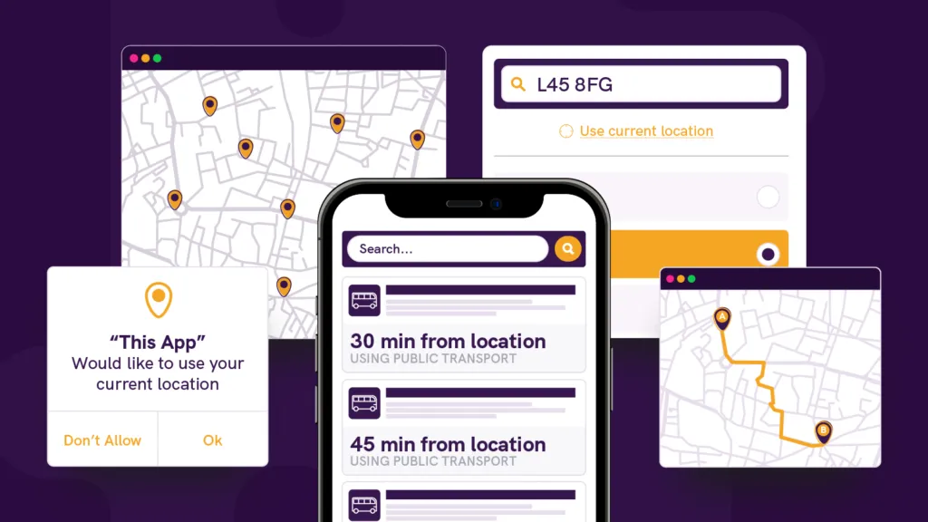
Look under the hood of the apps that you use on a regular basis and you’re bound to find location data. The cool thing is that you hardly ever realise that you are interacting with location data in the sense that we, geospatial people, might interact with it on a regular basis.
The other hand, I was booking a hotel room in Munich and the main factor for me was ‘how many minutes do I need with public transportation to reach the center of the city’ and even though I’ve lived several years in the city, I hardly benefitted from looking at the actual location of the hotel. In the end, the app that provided me this information was the one with the superior UX.
Its fascinating to think that location data and analytics can only be used for making business decision e.g. where to open the next McDonald’s but also to give your app/website a competitive advantage through the user experience. It seems to have the ability to drive higher conversions and signups, maximise the time users spend in an app and create customer satisfaction.
Would you agree with this statement or do you think it’s an oversimplification?
Using Location Data to Create Amazing User Experiences Online
If all this sounded interesting to you and you’d like to learn more about the topic and exchange your opinions with the rest of the community, Join us on 5th April for our event #24 to see real world use cases of how location data is used to deliver amazing user experiences and achieve business goals.
Register here.


#Featured


Next article
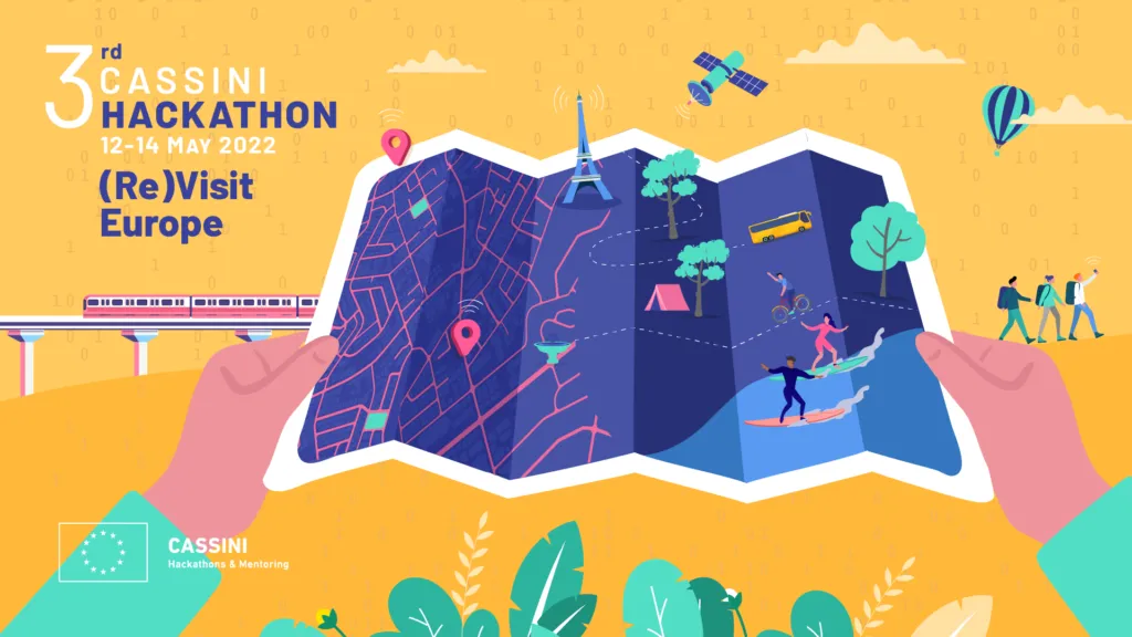

The third CASSINI hackathon is finally happening on May 12-14, 2022. This time the theme of the event is (Re)Visit Europe. The participants will help improve the tourism sector’s resilience, sustainability, and digitalisation. The EU and regional and national governments need your help to revitalise tourism and create new ways to access European destinations!
Your team will need to focus on developing ideas based on at least one of the following technologies:
- geospatial information from Copernicus Earth Observation data and its services
- positioning technologies from Galileo & EGNOS
- emerging digital technologies (e.g. machine learning, augmented/virtual reality or blockchain)
What are the challenges to be solved?
Each hacking team will need to select one of three challenges. The challenges require them to design products, devices or services with a specific goal:
Challenge #1: Finding sustainable destinations. Where to go and how to get there?
Design products, devices or services that reduce the carbon footprint of tourism travel. If you choose this challenge, you’ll be encouraged to dive into carbon footprint measurement of travel, understanding travel patterns between cities/countries, alternative destinations and modes of transport, online travel agents and other intermediaries and new, disruptive travel concepts.
Challenge #2: Experiencing cities and cultures. What to visit and who to meet?
Design products, devices or services that offer tourists a unique and sustainable experience of our cities and cultural heritage. If you choose this challenge, you’ll be encouraged to explore crowd management and slow tourism, personal recommendations and itineraries, social recognition and social media, state-of-the-art, virtual travel experiences and support local businesses and communities.
Challenge #3: Exploring nature with care. What outdoor activities to do?
Design products, devices or services that can help offer tourists a unique and sustainable opportunity to explore our nature. If you choose this challenge, you’ll be encouraged to focus on tourist information about the environmental state, conservation of local wildlife and biodiversity, generation of (new) routes, points of interest and activities, social recognition and social media and support local businesses and communities.
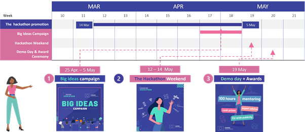
Where, when and how to participate?
Local organisers will host all ten events delivered in a Hybrid off-site and on-side mode simultaneously in Austria, Denmark, France, Greece, Hungary, Italy, Netherlands, Norway, Poland, Portugal. Participation requirements include living in an EU member state, Switzerland, Norway or Iceland. You should register your team by the 5th of May..
Here is the timeline:
Is it worth it?
Hackathons are a great way to push your creative mind to develop extraordinary ideas in a short time. It’s just three days that can change your life and accelerate your career. You don’t need to be a great developer or geospatial expert. You get plenty of support from the experts during the event, but you need a solid drive to create great products or services that are enabled by space technologies. The hackathon is open to anyone with a passion for entrepreneurship, tourism, and EU space technologies.
Don’t wait up! Register your team here: https://hackathons.cassini.eu/

